Hikes on California’s Central Coast
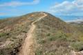
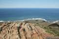
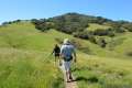
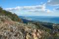
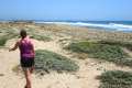
The Central Coast possesses some of the most scenic hiking in California, especially for those who enjoy ocean views. Numerous small parks protect the area’s green spaces and many are free to the public.
Highlights of California’s Central Coast


Hiking California’s Central Coast
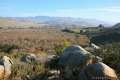
Los Padres National Forest is the major protective body on the Central Coast, preserving mountain ranges that span across Monterey, San Luis Obispo, Santa Barbara, and Ventura counties. The highest peak in the national forest, Mount Pinos, rises to 8,831 feet. Twenty miles to the south is the tallest waterfall, Rose Valley Falls.
An Adventure Pass ($5 per day or $30 per year) is required to access some trails in the approximately two million acre of land protected by Los Padres National Forest. Adventure Passes for Los Padres National Forest are valid for other national forests in Southern California as well, like Angeles National Forest, Cleveland National Forest and San Bernardino National Forest. Passes may be purchased within the park and at various local retailers. Those without a pass may still enjoy several free entry points that are located outside the national forest boundary. An “America the Beautiful” National Parks and Federal Recreational Lands Pass can also be used in lieu of an adventure pass.
Most of the trails listed below do not require any pass or permit. San Luis Obispo is a particularly great area for hikers, with a high number of free and scenic trails. While it is inland from the ocean, Pinnacles National Park is also included in this region. Take a trip to the Central Coast today!
Central Coast Hiking
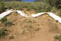
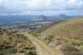
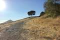
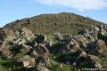
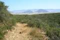
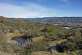
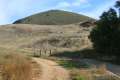
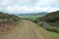
This collection of trails in the Central Coast region of California between Monterey County and Ventura County lists hikes from west to east and north to south. The table may also be sorted alphabetically or by distance to help you pick your next hike. Each trail links to its own report complete with photos, GPS maps, elevation profiles, directions, and all the other information needed to locate and enjoy these hikes.
Trail | Description | Distance | Location |
|---|---|---|---|
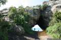
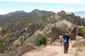 005 005 | High Peaks - Balconies Cave Loop This big loop ventures between the east and west sides of Pinnacles National Park, crossing through the High Peaks and Balconies Cave. | 9 miles 1,575 feet | 36.495027, -121.173052 |
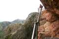 010 010 | High Peaks - Condor Gulch Loop This loop forges a route through the High Peaks in Pinnacles National Park to offer panoramic views on an incredible trek. | 5.3 - 6 miles 1,325 feet | 36.4785, -121.1838 |
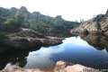 013 013 | Bear Gulch Reservoir This out and back hike takes a fun course through talus caves to reach a reservoir on the east side of Pinnacles National Park. | 1.5 miles 275 feet | 36.4785, -121.1838 |
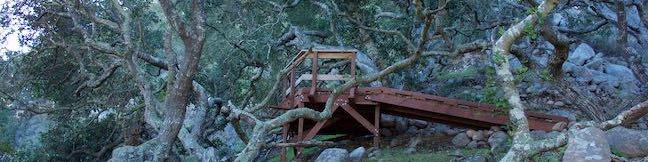
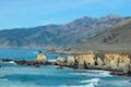
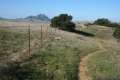
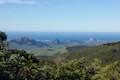
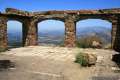
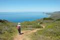 017 017 | Ridge Trail - Panorama Trail - Bluff Trail Loop This loop in Andrew Molera State Park crosses a coastal ridge, bluff, and beach that are packed with amazing Big Sur views. | 8.7 miles 1,100 feet | 36.287409, -121.8441 |
 020 020 | Pfeiffer Falls and Valley View This out and back trek is like two hikes in one, reaching a waterfall in a canyon of redwoods and a vista point overlooking the Big Sur River Valley. | 2.4 miles 550 feet | 36.25066, -121.7858 |
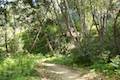 022 022 | Nature Trail - River Path Loop This easy loop explores woodlands along the Big Sur River and a redwood grove that includes the unique and impressive Proboscis Tree. | 0.55 miles 15 feet | 36.250472, -121.781215 |
 025 025 | Big Sur River Gorge This off-trail hike ventures up the Big Sur River on a water-wading boulder-hopping adventure to a crystal clear pool that’s a gorgeous Big Sur swimming hole. | 0.5 50 feet | 36.2464, -121.7721 |
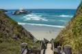
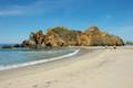 030 030 | Pfeiffer Beach This short walk reaches an absolutely stunning beach that's a classic feature of the Big Sur landscape. | 0.2 miles (or more) 10 feet | 36.2382, -121.81353 |
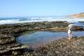
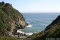 050 050 | Partington Cove This out and back hike visits a tunnel-accessed cove and a secluded beach along the scenic coast of Julia Pfeiffer Burns State Park. | 1.5 miles 270 feet | 36.1770, -121.6937 |
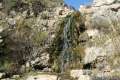
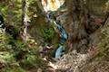 053 053 | Canyon Falls This out and back hike in Julia Pfeiffer Burns State Parkheads inland up McWay Creek past a picnic area in a redwood grove to a lovely little waterfall. | 0.9 miles 225 feet | 36.16014, -121.668523 |
 055 055 | McWay Falls This out and back hike in Julia Pfeiffer Burns State Park looks out on a stunning Big Sur waterfall that pours 80 feet right on to the beach. | 0.6 miles 50 feet | 36.1587, -121.67054 |
 057 057 | Hare Creek Trail, Limekiln Trail, and Falls Trail This out and back hike in Limekiln State Park explores a trio of trails along lovely streams in redwood-lined canyons, reaching Limekiln Falls and historic lime kilns. | 2.65 miles 250 feet | 36.010436, -121.518588 |
 060 060 | Pacific Valley Bluff Trail This short out and back hike extends from Highway One to an ocean bluff with fantastic views of the Big Sur Coast. | 1.1 miles 50 feet | 35.932648, -121.468927 |
 063 063 | Sand Dollar Beach This short hike to Big Sur's longest beach passes two scenic overlooks on the way to the sand. | 0.5 miles (or more) 125 feet | 35.921639, -121.466913 |
 065 065 | Jade Cove and Plaskett Rock Point This loop across ocean bluff visits a prominent peninsula and a small cove. | 1.5 miles 150 feet | 35.91705, -121.46905 |
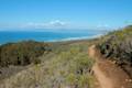
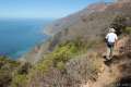 070 070 | Cruickshank Trail This hike into Silver Peak Wilderness starts with bold ocean views and crosses redwood groves to reach Upper Cruickshank Camp at a junction with Buckeye Trail, 2.5 miles from Highway One. | 5 - 9.25 miles 1,150 - 1,925 feet | 35.843073, -121.403025 |
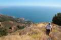 075 075 | Buckeye Trail This hike reaches incredible ocean vistas and trail camps in the Silver Peak Wilderness. Connect Cruickshank Trail and Buckeye Trail for an excellent shuttle hike of 8.25 miles or more. | 6.5 - 9.25 miles 1,450 - 1,925 feet | 35.821754, -121.374454 |
 080 080 | Salmon Creek Falls This out and back hike visits a fine 120-foot waterfall near the start of Salmon Creek Trail. | 0.25 miles 60 feet | 35.816032, -121.356699 |
 075 075 | Piedras Blancas This out and back hike ventures up the coast from the Piedras Blancas Elephant Seal Rookery to Piedras Blancas Light Station. | 3.2 - 4.2 miles 25 feet | 35.664401, -121.262713 |
 085 085 | Moonstone Beach Boardwalk This out and back hike crosses a boardwalk along a charming Cambria beach in Hearst San Simeon State Park. | 2.85 miles 40 feet | 35.568999, -121.105867 |
 086 086 | Bluff Trail (in Fiscalini Ranch Preserve) This easy stroll crosses beautiful undeveloped coastline at the center of Cambria. | 1.85 - 1.9 miles 50 - 80 feet | 35.55613, -121.1024 |
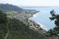
 088 088 | Headlands Trail This gradual lollipop loop in Harmony Headlands State Park crosses a coastal valley to reach picturesque ocean bluffs on the rugged coast between Cayucos and Cambria. | 4.5 miles 135 feet | 35.477783, -120.992263 |
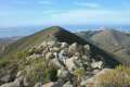
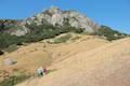
 090 090 | Cerro Alto This semi-loop bags one of the highest peaks in San Luis Obispo County. | 5.35 miles 1,600 feet | 35.424271, -120.738988 |
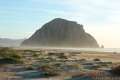 095 095 | Morro Rock via Morro Strand Trail This level stroll starts from Cloisters Park and crosses Morro Strand State Beach to reach Morro Rock. | 1 - 3.5 miles 25 feet | 35.38898, -120.860108 |
 098 098 | Black Hill This out and back hike in Morro Bay State Park summits of one of the Nine Sisters with 360-degree views over Morro Bay. | 0.6 miles 175 feet | 35.358059, -120.833378 |
 100 100 | Turtle Rock This easy out and back hike reaches a short rise between Black Hill and Cerro Cabrillo in Morro Bay State Park. | 2.1 miles 200 feet | 35.346512, -120.825198 |
 115 115 | Cerro Cabrillo This tough out and back hike summits the highest mountain in Morro Bay State Park, a 911-foot member of the Nine Sisters. | 2.5 miles 900 feet | 35.346512, -120.825198 |
 120 120 | Portola Point This loop explores a short hill in Morro Bay State Park just east of Morro Estuary with an easy-to-reach ocean overlook. | 2 miles 315 feet | 35.346512, -120.825198 |
 122 122 | Chumash & Crespi Trails Loop This hike in Morro Bay State Park visits an oak grove and bay views by combining Chumash Trail, Crespi Trail, and Hutash Trail. | 2.9 miles 420 feet | 35.3315, -120.81645 |
 125 125 | Eagle Rock Nature Trail This loop climbs to Eagle Rock Viewpoint in El Chorro Regional Park for an overview of the valley between San Luis Obispo and Morro Bay. | 2.4 miles 450 feet | 35.33567, -120.727234 |
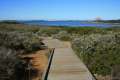 130 130 | Elfin Forest Natural Reserve This easy boardwalk loop explores a pygmy forest on the edge of Morro Bay. | 1 mile 80 feet | 35.331678, -120.82539 |
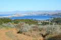 135 135 | Morro Dunes Ecological Reserve This lollipop loop serves up panoramic views over Morro Bay as it climbs from Los Osos to Montaña de Oro State Park. | 2.6 miles 800 feet | 35.308454, -120.843157 |
 140 140 | Los Osos Oaks State Natural Reserve This short hikes explores a pygmy forest of coast live oaks, providing a shady level stroll on overlapping loops. | 0.75 - 1.5 miles 25 feet | 35.306274, -120.813509 |
 145 145 | Hazard Canyon Reef This short hike in Montaña de Oro State Park descends an oceanfront ravine to a rocky shoreline graced with engaging tide pools. | 1 mile 100 feet | 35.285512, -120.881105 |
 145 145 | Hazard Peak via Bloody Nose Trail, Hiedra Trail, and Hazard Peak Trail This hike rises through a eucalyptus grove and views of Morro Bay to a panoramic summit in Montaña de Oro State Park. | 5.55 miles 950 feet | 35.2854, -120.8801 |
 148 148 | South Dune Trail – Bloody Nose Trail – Hiedra Trail – Hazard Peak Trail Loop This four-trail loop through dunes and eucalyptus trees rises to lovely coastal views. | 2.67 miles 310 feet | 35.277106, -120.884546 |
 150 150 | Hazard Peak Trail This out and back hike in Montaña de Oro State Park ascends coastal ridges to a 1,076-foot summit with panoramic views that include a dynamic perspective of Morro Bay. | 6 miles 950 feet | 35.277106, -120.884546 |
 155 155 | Hazard Peak - Islay Creek Loop This Montaña de Oro State Park loop continues beyond Hazard Peak deeper into the Irish Hills before circling back to the coast on Islay Creek Trail. | 9.2 miles 1,00 feet | 35.277106, -120.884546 |
 160 160 | Islay Creek Trail This easy out and back hike in Montaña de Oro State Park follows a wide trail up a coastal canyon flanked by thousand-foot peaks, passing a small waterfall to reach an abandoned barn. | 6 miles 300 feet | 35.276412, -120.885504 |
 164 164 | Reservoir Flats Trail This loop delivers fine ocean and canyon views as it explores the bottom of Islay Creek Canyon in Montaña de Oro State Park. | 2 miles 200 feet | 35.273872, -120.88553 |
 167 167 | Oats Peak This out and back hike reaches a panoramic summit that looks down over Montaña de Oro State Park. | 10.8 miles 1,325 feet | 35.273872, -120.88553 |
 170 170 | Valencia Peak This out and back hike summits a 1,347-foot peak with panoramic views over Montaña de Oro State Park. | 4.5 miles 1,275 feet | 35.272858, -120.888755 |
 180 180 | Bluff Trail (in Montaña de Oro State Park) This out and back hike of around three miles tours tide pools, beaches, and impressive cliffs along a picturesque coastline. | 1 - 5 miles 90 -140 feet | 35.2728, -120.8887 |
 182 182 | Rattlesnake Flats Trail – Badger Trail – Bluff Trail Loop This loop offers a twist on the Bluff Trail, going along and just above the coast of Montaña de Oro State Park. | 1.65 miles 150 feet | 35.272858, -120.888755 |
 188 188 | Coon Creek Trail This out and back hike ventures up a coastal canyon at the south end of Montaña de Oro State Park. | 5 miles 250 feet | 35.257927, -120.886988 |
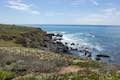
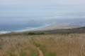
 190 190 | Point Buchon Trail This short scenic loop or longer out-and-back hike explores the beautiful coastline south of Montaña de Oro State Park. | 1.33 - 6.8 miles 75 feet | 35.257964, -120.887483 |
 192 192 | East Cuesta Ridge This wide dirt road offers out and back hikes to the tops of Mount Lowe and Lopez Canyon Trail, offering ocean views over San Luis Obispo and inland views over an evergreen wilderness. | 8.4 - 10.2 miles 1,015 - 1,075 feet | 35.34995, -120.63175 |
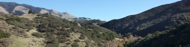
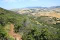
 193 193 | Cuesta Ridge Botanical Area This out and back hike crosses a ridge in the Santa Lucia Mountains with panoramic views over San Luis Obispo, ascending to a grove of Sargent cypress in a botanical area in Los Padres National Forest. | 6 miles 950 feet | 35.347125, -120.63045 |
 195 195 | Stenner Creek Trail to The Eucs This out and back hike goes up Stenner Creek Canyon past a small waterfall and views of Bishop Peak to a collection of freeride bike trails called the Eucs. | 3.7 miles 650 feet | 35.33016, -120.6631 |
 196 196 | Stenner Creek Trail – Red Dog Trail – Poly Canyon Road Loop This loop goes beyond the Eucs atop Stenner Creek Trail to explore grass-covered slopes at the base of the Santa Lucia Mountains. | 4.25 miles 550 feet | 35.33016, -120.6631 |
 200 200 | Poly Canyon Design Village This lollipop loop hike visits an architectural village designed by Cal Poly students at the base of the Santa Lucia Mountains. | 2.5 miles 300 feet | 35.30445, -120.65845 |
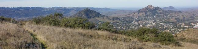
 208 208 | Felsman Loop Trail This loop crosses oak, sagebrush, and grass-covered slopes around the base of Bishop Peak, providing excellent views of that notable rocky summit and its San Luis Obispo surroundings. | 2.7 miles 525 feet | 35.30433, -120.685438 |
 210 210 | Bishop Peak This out and back hike summits the tallest of the Nine Sisters for excellent views over San Luis Obispo. | 3.5 miles 950 feet | 35.30433, -120.685438 |
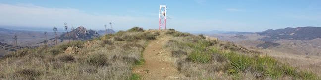
 220 220 | Reservoir Canyon Trail This steep hike passes a waterfall and a collection of junk sculptures en route to a treeless summit overlooking San Luis Obispo. | 5.35 miles 1,350 feet | 35.29097, -120.6280 |
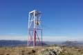 221 221 | Reservoir Canyon Summit Trail This hike ascends to a point on the northwest end of the ridge above Reservoir Canyon, presenting panoramic views over San Luis Obispo from the base of an old tower with a bell that can be rung with a thrown pebble. | 4.1 miles 1,175 feet | 35.29097, -120.6280 |
 222 222 | Reservoir Canyon Trail - Summit Trail Loop This loop ventures up Reservoir Canyon Trail to the summit viewpoint, crosses Ridge Trail to the bell tower, and descends Summit Trail back into Reservoir Canyon. | 5.6 miles 1,350 feet | 35.29097, -120.6280 |
 224 224 | Creek Bypass Trail Loop This short hike connects Summit Trail and Reservoir Canyon Trail with a short trail offering broad canyon views. | 1 mile 150 feet | 35.29097, -120.6280 |
 225 225 | Rinconada Trail & Bell Mountain This hike near Santa Margarita ascends past an old mercury mine and bucolic views to a grassy saddle with a sweeping perspective over the Santa Lucia Mountains. Extend the outing to a nearby summit for even grander vistas. | 3 - 3.25 miles 625 - 865 feet | 35.28995, -120.47485 |
 230 230 | Lemon Grove Loop Trail This easy loop visits a historic lemon grove on the eastern slopes of Cerro San Luis. | 2.2 miles 300 feet | 35.2749, -120.67237 |
 235 235 | Lemon Grove & "M" Trails Loop This outing uses all of the "M" Trail and part of Lemon Grove Loop Trail for a scenic circuit on the east side of Cerro San Luis. | 2.4 miles 560 feet | 35.2749, -120.67237 |
 240 240 | Cerro San Luis This hike summits one of the Nine Sisters just west of downtown San Luis Obispo. | 4 - 5 miles 1,100 feet | 35.2749, -120.67237 |
 250 250 | "M" Trail This spur off the trail up Cerro San Luis leads to a large white "M" installed halfway up the east side of the mountain. | 1.9 miles 560 feet | 35.274897, -120.672369 |
 255 255 | Cerro San Luis from Laguna Lake Park This out and back hike summits one of the Nine Sisters just west of downtown San Luis Obispo. | 5.7 miles 1,150 feet | 35.26521, -120.68274 |
 260 260 | Sydney Street Trail to Murray Hill (Unnamed Hill) This out and back hike climbs a steep rugged trail to a stone seating area at a panoramic summit. | 2.8 miles 1,275 feet | 35.27307, -120.641322 |
 267 267 | Terrace Hill This hike tours a flattened mountaintop in the city of San Luis Obispo that hosts panoramic views of the surroundings. | 0.55 miles 110 feet | 35.2725, -120.64886 |
 270 270 | South Hills Ridge Trail This out and back hike visits the top of a cluster of hills near downtown San Luis Obispo, offering fine views over the city and surroundings. | 1.5 miles 425 feet | 35.2666, -120.66434 |
 280 280 | Morro View in the Irish Hills This out and back hike in Irish Hills Natural Reserve delivers panoramic views over Los Osos Valley and the full chain of Morros. | 3.15 miles 850 feet | 35.262195, -120.71195 |
 290 290 | Froom Creek Trail Loop in the Irish Hills This loop explores a canyon on the east side of the Irish Hills before ascending to a nice view over Laguna Lake, Cerro San Luis, and Bishop Peak. | 3 miles 500 feet | 35.25431, -120.69525 |
 295 295 | Old Prospector Trail Loop in the Irish Hills This lollipop loop hike ventures up a rugged ravine off Froom Canyon to the ruins of an old mine. | 3.4 - 4.4 miles 650 feet | 35.25431, -120.69525 |
 300 300 | Islay Hill This out and back hike summits San Luis Obispo's easternmost Morro. | 1.8 miles 550 feet | 35.243296, -120.627131 |
 308 308 | Johnson Ranch - Irish Hills Connector Trail This scenic point-to-point hike connects Johnson Ranch Open Space with Irish Hills Natural Reserve. | 5 - 10 miles 575 feet | 35.223448, -120.693313 |
 310 310 | Johnson Ranch Loop This loop explores rolling hills in a grassy open space just south of San Luis Obispo. | 2.5 - 3.7 miles 200 feet | 35.223448, -120.693313 |
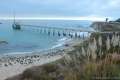
 315 315 | Point San Luis Lighthouse via Pecho Coast Trail This docent-led hike crosses scenic coastal bluffs to reach the historic lighthouse on Point San Luis. | 3.5 miles 300 feet | 35.174146, -120.756013 |
 320 320 | Bob Jones Bike Trail This easy round trip hike or ride follows San Luis Obispo Creek to Avila Beach. | 5 miles 50 feet | 35.185651, -120.703016 |
 330 330 | Sycamore Crest Trail This out and back hike ascends the north slope of Ontario Hill to a scenic ocean view perch. | 1.75 - 3.25 miles 575 feet | 35.186, -120.7146 |
 340 340 | Shell Beach Bluff Trail - Ontario Ridge Trail This loop explores the coast between Shell Beach and Avila Beach, on and below a 700-foot ridge. | 2.8 miles 675 feet | 35.1758, -120.7192 |
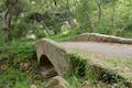
 350 350 | Cave Landing This short out and back hike descends to a natural rock bridge at the end of a headland east of Avila Beach. | 0.5 miles 100 feet | 35.1758, -120.7192 |
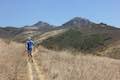
 370 370 | Hi Mountain Trail This short trail goes through many phases as it explores the Santa Lucia Mountains east of Arroyo Grande and combines with part of Hi Mountain Road to form a loop. | 3.25 miles 575 feet | 35.2075, -120.38237 |
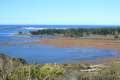
 380 380 | Oso Flaco Lake Trail This hike takes a boardwalk over a coastal lake and across sand dunes to an out-of-the-way beach. | 2 miles or more 25 feet | 35.0288, -120.6171 |
 550 550 | Nojoqui Falls This short out and back hike visits an 80-foot tall fern-lined waterfall. | 0.65 miles 175 feet | 34.528556, -120.172473 |
 550 550 | Gaviota Pass Overlook Loop This loop tours scenic ridges in Gaviota State Park to arrive at a soaring overlook above the Gaviota Tunnel. | 6.5 miles 650 feet | 34.507693, -120.22795 |
 560 560 | Gaviota Peak This loop mounts a 2,458-foot summit two miles from the Pacific and then descends Trespass Trail to explore the wilds of the Santa Ynez Mountains. | 6.5 miles 2,150 feet | 34.5046, -120.2259 |
 570 570 | Gaviota Hot Springs This short hike visits a warm hot springs along the trail to Gaviota Peak. | 1 mile 400 feet | 34.5046, -120.2259 |
 580 580 | Tunnel View and Trespass Trails Loop This loop steals views over the 101 Freeway and the Gaviota Tunnel from Gaviota State Park. | 2.6 miles 600 feet | 34.5046, -120.2259 |
 590 590 | Gaviota Wind Caves This out and back hike just off the 101 Freeway in Gaviota State Park visits wind-carved caves with great ocean views. | 2.5 miles 650 feet | 34.47172, -120.2297 |
 595 595 | Nature Trail in El Capitán State Beach This loop explores a lush sycamore grove bordering El Capitán Creek to approach the rocky shore at the end of El Capitán Point. | 0.35 miles 18 feet | 34.460105, -120.023608 |
 600 600 | Tequepis Trail This out and back hike delivers views of Lake Cachuma as it climbs the Santa Ynez mountains to a saddle overlooking the Pacific. | 8.4 miles 2,300 feet | 34.5525, -119.9565 |
 610 610 | Knapp's Castle This easy hike visits the scenic ruins of an estate home built atop the mountains behind Santa Barbara. | 0.8 miles 50 feet | 34.518155, -119.793234 |
 620 620 | Chumash Painted Cave This very short trail looks in on Native American rock art in the Santa Ynez Mountains. | 0.1 miles 20 feet | 34.50448, -119.78773 |
 630 630 | Lizard’s Mouth This short out and back hike visits a unique rock formation with amazing views over Santa Barbara and the Pacific. | 0.5 miles 25 feet | 34.503055, -119.86569 |
 640 640 | Inspiration Point from San Roque Road This out and back hike up the western side of Jesusita Trail reaches a panoramic perch in the Santa Ynez Mountains overlooking Santa Barbara. | 7.55 miles 1,400 feet | 34.45432, -119.72875 |
 642 642 | Inspiration Point from Tunnel Road This out and back hike combines Tunnel Trail and Jesusita Trail to ascend Mission Canyon to a sweeping viewpoint that looks down over Santa Barbara and up into the Santa Ynez Mountains. | 3.75 miles 825 feet | 34.46492, -119.71272 |
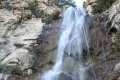 650 650 | Tangerine Falls This out and back hike crosses a lush canyon to a beautiful waterfall on the edge of Los Padres National Forest near Santa Barbara. | 875 feet | 34.45605, -119.6533 |
 660 660 | Montecito Peak This partial loop climbs to a panoramic summit in Los Padres National Forest overlooking Montecito and Santa Barbara. | 7.1 miles 2,450 feet | 34.456058, -119.6533 |
 670 670 | McMenemy Overlook This hike uses four trails to form a loop to a vista point in the Santa Ynez Mountains behind Montecito. | 3.7 miles 1,000 feet | 34.446008, -119.622303 |
 673 673 | Ennisbrook Trail This easy lollipop loop crosses charming stone bridges over San Ysidro Creek to explore a lush oak forest that is flooded by nasturtiums in the spring. | 1.85 miles 150 feet | 34.425482, -119.622238 |
 680 680 | Carpinteria Salt Marsh Nature Park This level out and back hike explores El Estuaro, a vital ecosystem for shorebirds. | 1.2 miles 10 feet | 34.395872, -119.528247 |
 690 690 | Carpinteria Bluffs Trail to Carpinteria Seal Sanctuary Overlook This short hike goes from Carpinteria Bluffs Nature Preserve to a viewing area above a harbor seal rookery, offering beach access and beautiful oceanfront hiking. | 1 - 2 miles 25 - 100 feet | 34.386929, -119.498625 |
 800 800 | Sespe Creek to Willett Hot Springs This out and back hike follows Sespe Creek to a relaxing hot springs. | 19 miles 500 feet | 34.5605, -119.1648 |
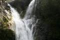
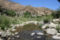
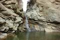
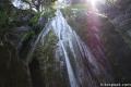 810 810 | Rose Valley Falls This out and back hike leads to the lower tier of a lovely two-tier 300-foot waterfall. | 0.8 miles 150 feet | 34.5317, -119.1829 |
 820 820 | Wheeler Gorge This loop explores the creek and forest on a nature trail around a 70-site campground in Los Padres National Forest. | 0.7 miles 100 feet | 34.518444, -119.271208 |
 823 823 | Horn Canyon Trail This hike in Ojai goes up a canyon in the frontcountry of the Topatopa Mountains and ventures off trail along the soothing waters of Thacher Creek. | 2.9 miles 750 feet | 34.46337, -119.17838 |
 824 824 | Sisar Canyon Trail This hike travels up a canyon to a viewpoint in the Topatopa Mountains between Ojai and Santa Paula. | 5.5 - 6.5 miles 1,125 - 1,200 feet | 34.44338, -119.13567 |
 827 827 | Santa Paula Canyon Trail to the Punchbowl This hike ventures up rugged Santa Paula Canyon to a waterfall and a Punchbowl of pools and cascades in Santa Paula Creek by Big Cone Camp. | 8 miles 800 feet | 34.4262, -119.0894 |
 830 830 | Ocean's Edge and River's Edge Trails Loop This level loop in Emma Wood State Beach borders the Pacific Ocean, the Ventura River, and an estuary flocked by seabirds. | 1.5 mile 25 feet | 34.28057, -119.315346 |
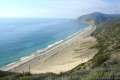
 840 840 | La Jolla Canyon Loop This hike explores Point Mugu State Park on the west end of the Santa Monica Mountains, offering incredible ocean views. | 11.75 miles 1,250 feet | 34.086097, -119.03688 |
 850 850 | Mugu Peak This out and back hike from La Jolla Canyon to the 1,266-foot summit features superb ocean and canyon views. | 6.5 miles 1,250 feet | 34.092697, -119.055712 |
 860 860 | La Jolla Canyon Falls This out and back hike visits a short seasonal waterfall in Point Mugu State Park. | 1.5 miles 250 feet | 34.093047, -119.043134 |
 870 870 | Scenic and Overlook Trails Loop This loop takes in tremendous ocean views above Big Sycamore Canyon in Point Mugu State Park. | 2.7 - 3.5 miles 450 to 550 feet | 34.071305, -119.012668 |
 880 880 | Grotto This out and back hike visits a remote grotto in the Santa Monica Mountains National Recreation Area. | 3 miles 500 feet | 34.109292, -118.937438 |
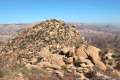
 890 890 | Sandstone Peak This loop summits the tallest peak in the Santa Monica Mountains. | 6.25 miles 1,075 feet | 34.111576, -118.926766 |
 900 900 | Tri Peaks This 1-mile addition to the Sandstone Peak loop adds extra views to the hike. | 7.45 miles 1,075 feet | 34.111576, -118.926766 |
 910 910 | Angel Vista via Rosewood Trail This out and back hike is the most direct route to a panoramic viewpoint overlooking the Conejo Valley. | 4 miles 800 feet | 34.176802, -118.912804 |
 920 920 | Angel Vista via West Los Robles Trail This out and back hike reaches an overlook on the north side of the Santa Monica mountains overlooking Thousand Oaks. | 7.6 miles 800 feet | 34.1719, -118.881 |
 922 922 | Oak Creek Canyon Trail This loop starts with an all-access nature trail with signs in English and Braille before transitioning to a less developed dirt single track, looping through chaparral and oak woodlands in Los Robles Open Space. | 0.8 miles 200 feet | 34.1753, -118.8856 |
 925 925 | Tarantula Hill This out and back hike follows a paved trail to the top of a small, round hill in Thousand Oaks with views across the Conejo Valley into the surrounding mountains. | 1 mile 275 feet | 34.195528, -118.885343 |
 930 930 | Paradise Falls in Wildwood Park This loop visits a 40-foot waterfall in the open spaces of Thousand Oaks. | 2.55 miles 260 feet | 34.2200, -118.9028 |
 940 940 | Lizard Rock To add extra mileage and views to a visit to Paradise Falls in Thousand Oaks, consider placing Lizard Rock on your itinerary. | 4.35 miles 570 feet | 34.2200, -118.9028 |
 950 950 | Rocky Peak This hike climbs to a 2,715-foot summit in Rocky Peak Park in the Santa Susana Mountains between Chatsworth and Simi Valley. | 4.75 miles 1,100 feet | 34.268362, -118.636155 |
 955 955 | China Flat & Simi Peak This hike ventures up rugged ridges to a peaceful oak savanna and a trail to the highest point in the Simi Hills, sporting 360-degree views of surrounding mountain ranges. | 5.45 - 6.2 miles 1,090 feet | 34.19536, -118.77684 |
 960 960 | Cave of Munits and Castle Peak This action-packed two-attraction loop crosses through an impressive cave to climb to a rocky peak with views over the San Fernando Valley. | 2.1 miles 750 feet | 34.195322, -118.658543 |