Gaviota Hot Springs
in Gaviota State Park
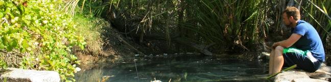
Driving up Highway 101 through the Gaviota Tunnel west of Santa Barbara, you might be unaware that a natural hot springs is less than a mile from the roadway. Gaviota Hot Springs is more warm than it is hot, but the blue sulfery water attracts its share of bathers. The springs are half a mile from the trailhead and only a tenth of a mile off the trail to Gaviota Peak, making it a nice detour if you have tired legs to soak.
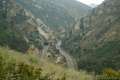
From the trailhead cul-de-sac just off Highway 101 in Gaviota State Park, begin hiking up the wide fire road, which climbs 150 feet over the first quarter mile to a junction with Trespass Trail (an alternate route to Gaviota Peak).
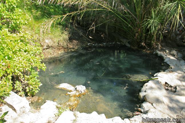
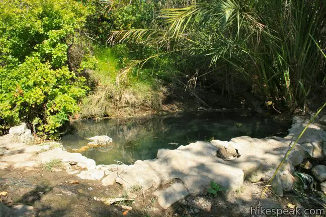
Turn left and continue up the road to the next junction located alongside a creek. This is the water flowing down from the hot springs. Turn right and follow the water to its source. A tenth of a mile up this overgrown single track, you will arrive at Gaviota Hot Springs.
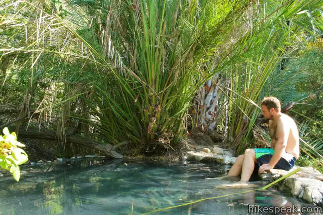
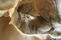
Some time ago, the small springs was built up with cement and separated into pools. Proceed up to the top pool which is deep enough to bathe in, but not to swim. Sulfur bubbles warm the milky blue water. Gaviota Hot Springs is on the small side, and the water would be more inviting if it circulated a bit more, but the springs is definitely worth checking out on the way to (or back from) Gaviota Peak. Done on its own, this is a one mile hike with 400 feet of elevation gain. A $2 fee is charged to park at the trailhead.
Directions to the Trailhead
- From Santa Barbara, drive 30 miles west on Highway 101.
- When the freeway turns inland, pass the Gaviota Rest Area and drive 1.5 miles to the next exit (132) labeled California One (Lompoc / Vandenberg AFB).
- At the top of the ramp, turn right.
- Then make another immediate right on the unnamed Gaviota Park Boundary Road.
- Continue 1/3 of a mile to the cul-de-sac at road's end.
- From Buellton to the north, take the 101 South for 8 miles to the exit for California One.
- Turn left and head across the freeway.
- Then make a right on the frontage road to the trailhead.
Trailhead Location
Trailhead address: Gaviota Park Boundary Road, Goleta, CA 93117
Trailhead coordinates: 34.504598, -120.2259 (34° 30′ 16.55″N 120° 13′ 33.23″W)
View Gaviota State Park in a larger map
Or view a regional map of surrounding Central Coast trails and campgrounds.

 | Gaviota Peak This 6.5-mile loop mounts a 2,458-foot summit two miles from the Pacific and then descends Trespass Trail to explore the wilds of the Santa Ynez Mountains. |
 | Tunnel View and Trespass Trails Loop This 2.6-mile loop steals a view over Highway 101 and the Gaviota Tunnel. |
 | Gaviota Pass Overlook Loop This 6.5-mile loop tours scenic ridges in Gaviota State Park to arrive at a soaring overlook above the Gaviota Tunnel. |
 | Gaviota Wind Caves This 2.5-mile hike just off Highway 101 visits wind-carved caves in Gaviota State Park with great ocean views. |
 | Nojoqui Falls This short 0.65-mile hike visits an 80-foot tall fern-lined waterfall. |
 | More Central Coast Hikes Explore other destinations along the California coast between Ventura and Monterey, including trails in Los Padres National Forest. |
 | Gaviota State Park Campground With 39 sites situated right next to the beach and proximity to many hiking trails, this coastal campground has a lot of appeal. |
 | Refugio State Beach Campground This 67-site campground is a great oceanfront camping destination along the coast west of Santa Barbara, just three miles from El Capitán State Beach. |
 | El Capitán State Beach Campground This 132-site campground offers oceanfront camping along the coast west of Santa Barbara, just three miles from Refugio State Beach. |
Common Questions about Gaviota Hot Springs in Gaviota State Park
- Is the trail open?
- Yes. You should expect to find that Hike to Gaviota Hot Springs is open. There are no recent reports of trail closures. If you discover that the trail is closed, please help your fellow hikers by reporting a closure.
- Do I need a permit for this hike?
- Yes. State Park Fee.
- How much time does this hike take?
- It takes approximately 45 minutes to hike Hike to Gaviota Hot Springs. Individual hiking times vary. Add extra time for breaks and taking in the views.
- How long is this hike?
- The hike to Hike to Gaviota Hot Springs is a 1 mile out and back with 400 feet of elevation change.
- Are dogs allowed on this trail?
- No, dogs are likely not allowed on Hike to Gaviota Hot Springs. The trail is primarily open to hikers.
- Is Hike to Gaviota Hot Springs good for kids?
- Yes, this hike is likely suitable for children. It is relatively short (1 miles) with manageable elevation gain.
- Are there hot springs on this hike?
- Yes, there are hot springs located along Hike to Gaviota Hot Springs.
- What mountain range is this trail in?
- Hike to Gaviota Hot Springs is located in the Santa Ynez Mountains.
- Where is the trailhead located?
- The trailhead for Hike to Gaviota Hot Springs is located in Goleta, CA.
Trailhead Address:
Gaviota Park Boundary Road
Goleta, CA 93117
Trailhead Coordinates:
34.5046, -120.2259 - What are the driving directions to the start of the hike?
To get to the trailhead: From Santa Barbara, drive 30 miles west on Highway 101. When the freeway turns inland, pass the Gaviota Rest Area and drive 1.5 miles to the next exit (132) labeled California One (Lompoc / Vandenberg AFB). At the top of the ramp, turn right. Then make another immediate right on the unnamed Gaviota Park Boundary Road. Continue 1/3 of a mile to the cul-de-sac at road's end.
From Buellton to the north, take the 101 South for 8 miles to the exit for California One. Turn left and head across the freeway. Then make a right on the frontage road to the trailhead.
View custom Google Maps directions from your current location.
- Are there other trails near Hike to Gaviota Hot Springs?
- Yes, you can find other nearby hikes using the Hikespeak Hike Finder Map.

10 Comments on Gaviota Hot Springs in Gaviota State Park
What hikers are saying:
✨ Generated summary of user commentsHikers find these natural hot springs to be a beautiful and worthwhile destination, especially on clear evenings. While the main fire road is well maintained, the final stretch of single-track trail can be overgrown with poison oak. Zoe warns visitors to perform thorough tick checks after their soak, as these pests are known to hide in hairlines and navels. Visitors should also keep dogs away from the water systems to maintain proper etiquette and hygiene.
“The hot springs is totally worth the trek out there.” Jump to comment ↓
Gaviota Hot Springs is a great trail and time for that matter! I was there this past summer and it was nice and hot and the springs were beautiful. I tend to stick to SB trails but I made the trek out there to check it out and it was so awesome! Great day hiking some new trails that I will now forever go back to.
The hot springs is totally worth the trek out there. Short way up the hill and you’re there and on a nice evening, this is the place to be! My local friends showed me this place when I was in town and it was one of the best places I’ve ever been in town! Just beautiful and natural in every way.
This is a short hike. We brought our two little boys – 6 and 3. The fire road is wide and well maintained. The last 1/10th of a mile of single-track from the fire road could use a little work. I’d bring a knife and some gloves next time to clear out some of the poison ivy starting to encroach on the trail up.
Cutting poison oak with a knife and gloves probably isn’t a good idea. You’re likely to get a good case of poison oak that way. Poison oak juice is powerful stuff and can spread around your body like magic.
[…] ascending, we checked out the Gaviota hot springs at the base of the trail. The water was warm to the touch, and the air smelled like sulfur. The […]
Can you bring a dog to the hot springs area?
In my personal opinion, you should not. Unless you will be sure to keep your dog a distance from the pools and do not allow them to urinate/defecate anywhere that is wet (part of the water “system”). It’s not great etiquette to have a dog tied up who may be barking or yipping for you as you are soaking. Signed- A long-time dog owner/hiker
Is this hike suitable for children under 6?
I was here this past weekend 4/1/22 and no this is not an April Fool’s joke. Please beware of ticks attaching to you. I went into the bushes to take off my bathing suit and dry off to get dressed and must have picked up the critter there. I found it in my belly button the next morning when I examined my navel to figure out why I had a burning sensation in my sleep. I didn’t know what I pulling out with tweezers until after I used Google Lens to identify it. I am sending it to a lab for testing to find out what I could have been infected with although I started Doxycycline the very next night as my doctor was concerned with the rash that quickly developed. In most cases, you won’t know they have attached but this sucker got smashed to death in my belly button because I wore tight jeans to dinner that same day.
Have someone help you check for ticks in the hairline, behind your ears and your belly button or groin area where they hide. Ticks carry a multitude of serious diseases including but not limited to Lyme Disease.
I was there last week for the first time. Thru amazing gusts and rain and the trail is demolished! I was not impressed with the main pool as it was not very warm however, all the rain would contribute to the temp.. Unless you wear Muck Boots I bushwacked down the adjacent road when it starts to go up the hill thats when you bushwack down the grassy hill into the trees. You will see a hillbilly settlement down the hill stay to your left, cross the creek and it will lead you back on the road to parking area. Hike -On!