Hikes in Wind Cave National Park

Wind Cave National Park is located in the Black Hills of South Dakota. President Theodore Roosevelt visited the cave in 1903 and created America’s eighth national park, the first to protect a cave. A decade later, a preserve was created next to the park to establish a bison heard. The herd thrived and in 1935, the game preserve became part of Wind Cave National Park. The park has continued to grow and now covers 33,851 acres.

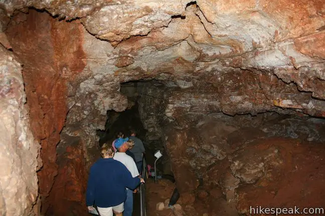
Most of Wind Cave National Park’s wonders are below ground, with rare boxwork cave formations and miles and miles of tunnels (some of which have yet to be explored. Wind Cave National Park has above ground appeal too, with hiking trails and changes to see bison in the wild.

Wind Cave National Park

Hiking Wind Cave National Park

Rankin Ridge Trail
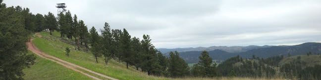
Rankin Ridge Nature Trail in Wind Cave Park
This one-mile loop hits the highest point in the park at a lookout tower with views over the east side of the Black Hills.


hikespeak
Bismarck Lake Campground in Black Hills National Forest
Bismarck Lake is a small, secluded 23-site campground in Black Hills National Forest, less than five miles east of Custer, South Dakota. While some sites offer obstructed views of the lake below, most sites are nestled back in the woods among ponderosa pines and large boulders. A lakeside boardwalk with benches and an elevated seated area leaves from the campground and offers greats spot for enjoying your morning tea or spotting wildlife. ...Read more.
Tagged with · Black Hills · Custer · Tent Camping
By: Published: September 10, 2015 Last updated: April 9, 2026
Rankin Ridge Nature Trail in Wind Cave National Park
Rankin Ridge forms part of the southeast edge of the Black Hills and at 5,013 feet in elevation, it is the highest point in Wind Cave National Park. A lookout tower rises above the ridge top, which can be reached via a 250-foot ascent on a 0.55-mile long single track. Take a wide dirt trail back down the ridge to form a one-mile loop. Although this hike is short, it is not short on rewards. ...Read more.
Distance: 1 mile · Elevation change: 250 feet
By: Published: August 18, 2015 Last updated: April 23, 2026
Crazy Horse Volksmarch in the Black Hills
It is not every day that you can hike to the top of a 563-foot tall granite carving honoring an American legend. Actually, you can only do this hike a few days a year when the active construction on Crazy Horse Memorial is suspended so that the public can get a close look. The hike passes through forests and fields below the work-in-progress memorial and follows the same road used by construction vehicles up to the arm of the monument where you can walk out and stand below the 8-story tall face of Crazy Horse! ...Read more.
Distance: 4.75 miles · Elevation change: 775 feet
By: Published: August 16, 2015 Last updated: December 5, 2025
Cliff Shelf Nature Trail in Badlands National Park
Beneath the natural fortress known as Badlands Wall, Cliff Shelf Nature Trail presents easy access to South Dakota's badlands and has views across the Great Plains. This pleasant half-mile lollipop loop passes through a juniper forest elevated along the Badlands Wall, a 100-mile long ridge spanning across the park. The start of the loop is wheelchair friendly, but steps lead to the highest viewing platform on this wide trail. ...Read more.
Distance: 0.5 miles · Elevation change: 300 feet
By: Published: March 29, 2012 Last updated: April 9, 2026
Notch Trail in Badlands National Park
This trek travels up a badlands canyon to an overlook with massive views over the Great Plains. The hike is 1.33 miles round trip with 125 feet of elevation gain. This hike does not have a boardwalk to follow, just a dirt trail and a steep wooden ladder. Notch Trail also traces a cliff's edge so it is not a good option for hikers with a fear of heights. ...Read more.
Tagged with · Badlands · National Parks
Distance: 1.33 miles · Elevation change: 125 feet
By: Published: March 29, 2012 Last updated: December 5, 2025