Hikes in Ventura County
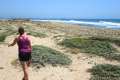
Ventura County is at the south end of the Central Coast of California with beautiful beaches and mountains. Numerous great hikes can be enjoyed by those in the region (or making quick getaways from Los Angeles).
Highlights of Ventura County


Hiking Ventura County
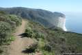
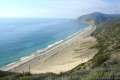
The west end of the Santa Monica Mountains extends into Ventura County, providing plenty of trails around Newbury Park and Thousand Oaks. Strolls along the beach can be found near the city of Ventura. The south end of the county includes parts of the Santa Monica Mountains, Simi Hills, and Santa Susana Mountains, which also extend into Los Angeles County. Beautiful coastal hikes can be found in Point Mugu State Park on the border of Malibu.
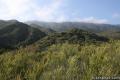
The city of Ojai is inland from the coast and wrapped by lovely green mountains. These are the Topatopa Mountains, protected by Los Padres National Forest, and packed with excellent hiking. Horn Canyon Trail, Sisar Canyon Trail, and Santa Paula Canyon Trail delve into the mountains just east of Ojai.
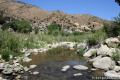
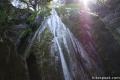
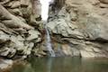
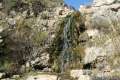
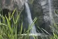
Route 33, Mariposa Highway, heads north of Ojai, offering a scenic drive into the mountains with numerous hairpin turns. Along the way are several places to hike and camp. The largest campground in the area is Wheeler Gorge with seventy sites and a pleasant one-mile loop trail. The tallest waterfall in the Los Padres, the two-tier 300-foot Rose Valley Falls, is located three miles off Route 33 and is easy to get to from the campground. East of the waterfall is Sespe Wilderness, where backpackers can trek to more remote locations, including Willett Hot Springs.
An adventure pass may be required for visits to Los Padres National Forest. Day passes cost $5 and an annual pass is $30. The passes may be purchased within the park, at various local retailers, and online. The passes are valid at other national forests in California as well, like Angeles National Forest.
Ventura Hiking
This collection of trails in Ventura County, California lists the hikes from west to east. The table may also be sorted alphabetically or by distance to help you pick your next hike. Each trail links to its own report complete with directions, photos, GPS maps, elevation profiles, and all the other information needed to locate and enjoy these hikes. You can also view hikes around Ventura County on the Hike Finder Map.
| Trail | Description | Distance | Location |
|---|---|---|---|
 800 800 | Sespe Creek to Willett Hot Springs This out and back hike follows Sespe Creek to a relaxing hot springs. | 19 miles 500 feet | 34.5605, -119.1648 |
 810 810 | Rose Valley Falls This out and back hike leads to the lower tier of a lovely two-tier 300-foot waterfall. | 0.8 miles 150 feet | 34.5317, -119.1829 |
 820 820 | Wheeler Gorge This loop explores the creek and forest on a nature trail around a 70-site campground in Los Padres National Forest. | 0.7 miles 100 feet | 34.518444, -119.271208 |
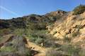
 823 823 | Horn Canyon Trail This hike in Ojai goes up a canyon in the frontcountry of the Topatopa Mountains and ventures off trail along the soothing waters of Thacher Creek. | 2.9 miles 750 feet | 34.46337, -119.17838 |
 824 824 | Sisar Canyon Trail This hike travels up a canyon to a viewpoint in the Topatopa Mountains between Ojai and Santa Paula. | 5.5 - 6.5 miles 1,125 - 1,200 feet | 34.44338, -119.13567 |
 827 827 | Santa Paula Canyon Trail to the Punchbowl This hike ventures up rugged Santa Paula Canyon to a waterfall and a Punchbowl of pools and cascades in Santa Paula Creek by Big Cone Camp. | 8 miles 800 feet | 34.4262, -119.0894 |
 830 830 | Ocean's Edge and River's Edge Trails Loop This level loop in Emma Wood State Beach borders the Pacific Ocean, the Ventura River, and an estuary flocked by seabirds. | 1.5 miles 25 feet | 34.28057, -119.315346 |
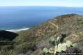 840 840 | La Jolla Canyon Loop This hike explores Point Mugu State Park on the west end of the Santa Monica Mountains, offering incredible ocean views. | 11.75 miles 1,250 feet | 34.086097, -119.03688 |
 850 850 | Mugu Peak This out and back hike from La Jolla Canyon to the 1,266-foot summit features superb ocean and canyon views. | 6.5 miles 1,250 feet | 34.092697, -119.055712 |
 860 860 | La Jolla Canyon Falls This out and back hike visits a short seasonal waterfall in Point Mugu State Park. | 1.5 miles 250 feet | 34.093047, -119.043134 |
 870 870 | Scenic and Overlook Trails Loop This loop takes in tremendous ocean views above Big Sycamore Canyon in Point Mugu State Park. | 2.7 - 3.5 miles 450 to 550 feet | 34.071305, -119.012668 |
 880 880 | Grotto This out and back hike visits a remote grotto in the Santa Monica Mountains National Recreation Area. | 3.5 miles 500 feet | 34.109292, -118.937438 |
 890 890 | Sandstone Peak This loop summits the tallest peak in the Santa Monica Mountains. | 6.25 miles 1,075 feet | 34.111576, -118.926766 |
 900 900 | Tri Peaks This 1-mile addition to the Sandstone Peak loop adds extra views to the hike. | 7.45 miles 1,075 feet | 34.111576, -118.926766 |
 910 910 | Angel Vista via Rosewood Trail This out and back hike is the most direct route to a panoramic viewpoint overlooking the Conejo Valley. | 4 miles 800 feet | 34.1768, -118.9128 |
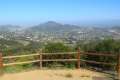 920 920 | Angel Vista via West Los Robles Trail This out and back hike reaches an overlook on the north side of the Santa Monica Mountains with views over Thousand Oaks. | 7.6 miles 800 feet | 34.1719, -118.881 |
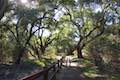 922 922 | Oak Creek Canyon Trail This loop starts with an all-access nature trail with signs in English and Braille before transitioning to a less developed dirt single track, looping through chaparral and oak woodlands in Los Robles Open Space. | 0.8 miles 200 feet | 34.1753, -118.8856 |
 925 925 | Tarantula Hill This out and back hike follows a paved trail to the top of a small, round hill in Thousand Oaks with views across the Conejo Valley into the surrounding mountains. | 1 mile 275 feet | 34.195528, -118.885343 |
 930 930 | Paradise Falls This loop visits a 40-foot waterfall in Wildwood Park, an open space in Thousand Oaks. | 2.55 miles 260 feet | 34.2200, -118.9028 |
 940 940 | Lizard Rock To add extra mileage and views to a visit to Paradise Falls in Thousand Oaks, consider placing Lizard Rock on your itinerary. | 4.35 miles 570 feet | 34.2200, -118.9028 |
 950 950 | Rocky Peak This hike climbs to a 2,715-foot summit in Rocky Peak Park in the Santa Susana Mountains between Chatsworth and Simi Valley. | 4.75 miles 1,100 feet | 34.268362, -118.636155 |
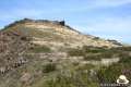
 955 955 | China Flat & Simi Peak This hike ventures up rugged ridges to a peaceful oak savanna and a trail to the highest point in the Simi Hills, sporting 360-degree views of surrounding mountain ranges. | 5.45 - 6.2 miles 1,090 feet | 34.19536, -118.77684 |
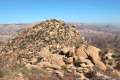
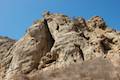 960 960 | Cave of Munits and Castle Peak This action-packed two-attraction loop crosses through an impressive cave to climb to a rocky peak with views over the San Fernando Valley. | 2.1 miles 750 feet | 34.195322, -118.658543 |
Or explore hikes around Ventura County on the Hike Finder Map