Hikes in Calaveras County

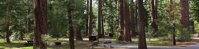
Made famous by one-time resident Mark Twain’s short story, The Notorious Jumping Frog of Calaveras County, this one thousand square mile swath of the sierra foothills has a lot to offer to present day visitors. In addition to the famed jumping frog jubilee and a popular wine-tasting town, Calaveras County has several areas for hiking. Not far from Yosemite National Park on the west side of the Sierra Nevada Mountains, the sparely populated county is covered with rugged subalpine woodlands largely protected by Stanislaus National Forest. Tree lovers can visit Calaveras Big Tree State Park, which was one of California’s earliest state parks, and protects the first grove of giant sequoias discovered by settlers.

Hiking Calaveras County

North Grove Big Trees Trail in Calaveras Big Trees State Park
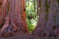
North Grove – Big Trees Trail in Calaveras Big Trees State Park
This easy 1.5-mile loop explores the first giant sequoias discovered by settlers in California in the North Grove of Calaveras Big Trees State Park
Natural Bridge of Calaveras County
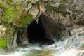
Upper Natural Bridge Trail
This fun 2-mile round trip hike descends into a canyon to a limestone tunnel in a creek (that you can swim through).
hikespeak
Fallen Leaf Lake Moraine Trail Lake Tahoe Basin South Lake Tahoe Hike
What's better than hiking by a lovely creek - maybe hiking by a lovely lake. You can do both on Moraine Trail, visiting Fallen Leaf Lake and Taylor Creek in the Lake Tahoe Basin National Forest Lands near South Lake Tahoe. This easy and level loop is 1.1 miles long, including a short side trail to Fallen Leaf Lake Dam. The mountain-cradled Fallen Leaf Lake is located just south of Lake... Read more.
OK! Add to trails I’ve hiked
OK! Add to trails I want to hike
Tagged with · Free Trails · Lake Tahoe Basin National Forest Lands · Lakes · South Lake Tahoe
Distance: 1.1 miles · Elevation change: 35 feet
By: Published: Last updated: July 26, 2023
Way of the Mono Trail Sierra National Forest Bass Lake View Hike Oakhurst California
Interpretive trails are usually good places to appreciate the finer features of a forest, but they tend to lack grand vistas. This is not the case with Way of the Mono Trail, which rises to a splendid view over Bass Lake, a beauty in the Sierra Nevada Mountains south of Yosemite National Park. Way of the Mono Trail is a 0.6-mile loop with 140 feet of elevation change. Panels along this... Read more.
OK! Add to trails I’ve hiked
OK! Add to trails I want to hike
Tagged with · Bass Lake · Free Trails · Lakes · Morteros · Native American Heritage · Nature Trails · Oakhurst
Distance: 0.6 miles · Elevation change: 140 feet
By: Published: Last updated: June 30, 2021
Chimney Beach Trail Lake Tahoe Nevada Chimney Beach Hike Humboldt-Toiyabe National Forest
Before your visit to Lake Tahoe goes up in smoke, take a hike to Chimney Beach - where a standing-on-its-own fireplace and chimney serve as an unsual landmark for a lovely little cove. The brick chimney is all that's left of an old cabin built in the sand between boulder-strewn points on the east shore of Lake Tahoe. If curiosity about the chimney draws you to Chimney Beach, the beautiful... Read more.
OK! Add to trails I’ve hiked
OK! Add to trails I want to hike
Tagged with · Beaches · Carson City · Free Trails · Ruins · South Lake Tahoe
Distance: 1.1 miles · Elevation change: 215 feet
By: Published: Last updated: July 26, 2023
Cave Rock Trail Lake Tahoe Nevada Overlook Hike
Gaze out from Route 50 as it travels along the southeast side of Lake Tahoe and you'll find nice views of the lakeshore and its surrounding mountains. Seven miles up from the state border in South Lake Tahoe, Nevada Route 50 slips through a tunnel in a tall pointed ridge of volcanic rock. The road itself is scenic, but the sight of Cave Rock should have you speculating how superb things must... Read more.
OK! Add to trails I’ve hiked
OK! Add to trails I want to hike
Tagged with · Free Trails · Glenbrook · South Lake Tahoe · Summits
Distance: 0.9 miles · Elevation change: 165 feet
By: Published: Last updated: July 26, 2023
Columbia Rock Yosemite National Park Columbia Rock Viewpoint Yosemite Falls Trail Hike Yosemite Valley California
Yosemite Valley looks great from the bottom up, the top down, and even the middle out. For this neither-up-nor-down view over Yosemite Valley, visit Columbia Rock, a viewpoint on Yosemite Falls Trail perched about thousand feet up the north wall of Yosemite Valley. The hike from Camp 4 up to Columbia Rock is 2.2 miles round trip with 985 feet of elevation change. Of course, continuing up... Read more.
OK! Add to trails I’ve hiked
OK! Add to trails I want to hike
Tagged with · National Parks · Yosemite Valley
Distance: 2.2 miles · Elevation change: 985 feet
By: Published: Last updated: January 31, 2018