Hikes in Yosemite National Park
Yosemite National Park protects nearly 1,200 square miles of stunning Sierra Nevada wilderness and draws approximately four million visitors each year. Tourists congregate in Yosemite Valley, a seven square mile sector that is undoubtedly one of the most spectacular places on the planet.
Highlights of Yosemite National Park


Yosemite National Park
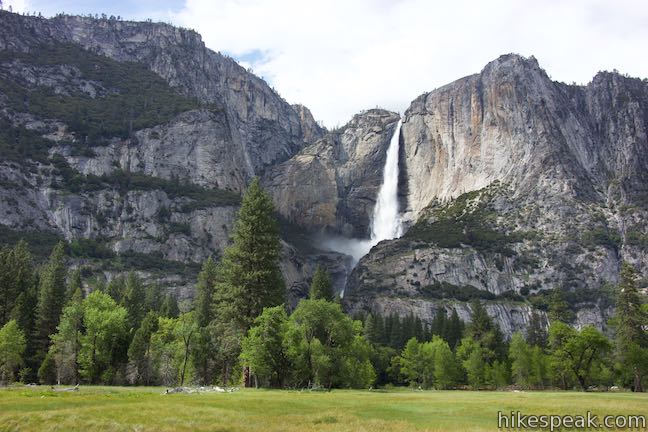
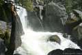
Yosemite Valley is hydrated by some of the tallest waterfalls in the world, including Yosemite Falls, the tallest waterfall in North America at 2,425 feet, and Ribbon Fall, the longest single-drop waterfall in North America with an epic 1,612-foot plunge.
Yosemite Valley is home to unforgettable hikes, including the bucket-list worthy ascent of Half Dome. Beyond Yosemite Valley, a vast backcountry provides endless hiking away from the crowds.
It is difficult to describe Yosemite’s magnificence without firing up the hyperbole generator. The waterfalls and granite domes are striking. Even seemingly average forests and meadows know to be a bit extra beautiful. John Muir, who fought for the park’s creation described Yosemite Valley this way:
It is by far the grandest of all the special temples of Nature I was ever permitted to enter.
Yosemite Valley is a special place.
Yosemite National Park is very accessible. Even without real hiking, the breathtaking views from drive-to overlooks like Tunnel View, Glacier Point, and Washburn Point, along with easy (you can wear sneakers) trails like Happy Isles, Bridalveil Fall Trail, and Lower Yosemite Fall Trail are enough to create a memorable trip itinerary.
The easiest way to get around Yosemite Valley is the free park shuttle. Leave your vehicle at Yosemite Village and use the shuttle loop to move around to different trails and points of interest. It is very important to practice good bear safety at all times inside the park.
Where to stay
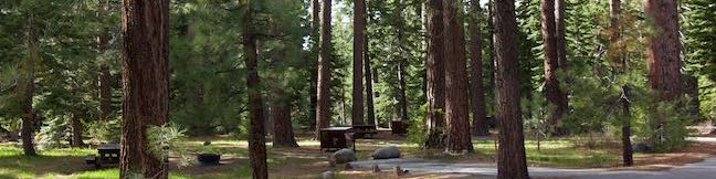
Yosemite National Park has numerous campgrounds as well as hotels and other lodging like Housekeeping Camp.
Yosemite National Park Hiking
This collection of trails and viewpoints in Yosemite National Park lists outings from north to south. The table may also be sorted alphabetically or by distance to help you select your next trek. Each trail or viewpoint links to a full report with photos, maps, directions, and all the other information needed to locate and enjoy these destinations. Below the table is an interactive map, showing the location of each trail and attraction.
| Trail | Description | Distance | Location |
|---|---|---|---|
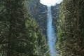
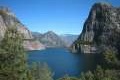 150 150 | Hetch Hetchy Reservoir and Wapama Falls This level hike tours a flooded valley to a thundering waterfall in the northwest corner of the park. | 5 miles 200 feet | 37.946905, -119.787376 |
 160 160 | May Lake This short east hike visits a peaceful alpine lake in the high elevation region of Yosemite north of Yosemite Valley. | 2.4 miles 475 feet | 37.832633, -119.49118 |
 170 170 | Mirror Lake This easy hike visits a relaxing reflective pool on the east end of Yosemite Valley. | 2 to 2.8 miles 100 feet | 37.739208, -119.56015 |
 177 177 | Happy Isles This short, easy hike explores a pair of islands in the Merced River at the east end of Yosemite Valley. | 0.75 miles 50 feet | 37.7324, -119.5598 |
 180 180 | Half Dome This epic hike climbs from Yosemite Valley to the top of the most iconic crest in the Yosemite landscape. | 16 miles 4,800 feet | 37.732567, -119.558282 |
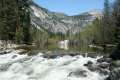
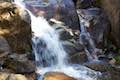
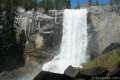 190 190 | The Mist Trail to Vernal Fall and Nevada Fall This exciting trail climbs the Merced River past two of Yosemite's prize waterfalls. | 1.8 to 6.1 miles 400 to 1,925 feet | 37.732567, -119.558282 |
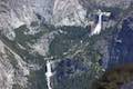
 200 200 | Panorama Trail This hike travels from Glacier Point down to Yosemite Valley in the most scenic way possible, ending with the Mist Trail. | 9.4 miles (one-way) 3,200 feet | 37.727942, -119.573476 |
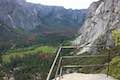
 205 205 | Glacier Point This 7,214-foot overlook towers above Yosemite Valley and provides incredible drive-up views. | 0.5 miles 50 feet | 37.727103, -119.574456 |
 206 206 | Washburn Point This Glacier Point adjacent overlook offers views of Half Dome, Vernal and Nevada Falls, and mountains in the Clark Range. | 0 miles | 37.7204, -119.5730 |
 207 207 | Columbia Rock This hike up the start of Yosemite Falls Trail reaches a perch with a sweeping perspective across Yosemite Valley that. | 2.2 miles 985 feet | 37.7423, -119.6021 |
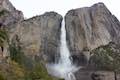 208 208 | Yosemite Falls Trail This hike rises above Columbia Rock to attain unforgettable views of Upper Yosemite Fall. | 3.5 to 7.1 miles 1,210 to 2,715 feet | 37.7423, -119.6021 |
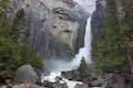 210 210 | Lower Yosemite Fall This electrifying loop delivers visitors to the base of the tallest waterfall in North America. | 1.2 miles 100 feet | 37.745347, -119.594777 |
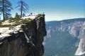 220 220 | Taft Point This out and back hike visits an overlook on the south wall of Yosemite Valley with fascinating rock fissures carved into the exposed granite. | 2 miles 250 feet | 37.7126, -119.586318 |
 230 230 | Bridalveil Fall This easy paved trail visits the base of a 620-foot single-drop waterfall on the south side of Yosemite Valley. | 0.5 miles 50 feet | 37.7168, -119.651 |
 233 233 | Wildcat Falls This short path finds a secluded cascade along El Portal Road near the Arch Rock Entrance of Yosemite National Park. | 0.15 miles 15 feet | 37.7215, -119.7151 |
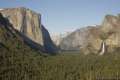 235 235 | Tunnel View Pull the car over at this extraordinary must see viewpoint looking up Yosemite Valley. | 0 miles | 37.715476, -119.67678 |
 240 240 | Chilnualna Falls This out and back hike begins near raucous cascades and ends atop a waterfall. | 8 miles 2,200 feet | 37.54839, -119.63369 |
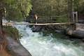 243 243 | Wawona Swinging Bridge This hike leads to a suspension bridge spanning a charming stretch of the South Fork Merced River in the Wawona Area of Yosemite National Park. | 0.8 to 1.4 miles 40 to 70 feet | 37.54637, -119.63015 |
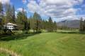 245 245 | Wawona Meadow Loop Trail This gentle hike passes through forest encircling a verdant, mostly-natural meadow near Wawona Hotel at the south end of Yosemite National Park. | 3.9 miles 250 feet | 37.53441, -119.6499 |
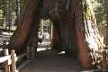 250 250 | Mariposa Grove of Giant Sequoias This hike explores the biggest trees in Yosemite, which can be seen on foot or by tram. | 1.6 to 8 miles 400 to 1,200 feet | 37.501462, -119.610862 |
Or explore hikes around Yosemite National Park on the Hike Finder Map