Best Hikes in Los Angeles
Los Angeles is blessed with something like 300 sunny days a year and an equally impressive number of worthwhile hiking trails. Combine nice weather and a nice trail and you’ll get a pretty nice day.
Hikespeak.com offers trail reports for over 175 hikes in Los Angeles. With so many trails to choose from, you may be asking the question:
What are the best hikes in Los Angeles?
The answer depends on what your interest in seeing and what time of year you are hiking. For example, waterfall hikes are great in the early months of the year by dry out by late summer and fall. The Hollywood Sign is a popular hiking destination year-round.
Have a look at this list of twelve great hikes in Los Angeles that should please the most scrutinizing outdoor enthusiasts. These hikes are listed in alphabetical order with brief descriptions and links to full write-ups.
The list includes the average rating for each hike as judged by the visitors of hikespeak.com. After exploring one of these highly recommended hikes, you can come back and provide a star rating of your own. If you have a favorite hike that you do not see on this list, please share it as a comment below.
As a bonus, you’ll find some deserving honorable mentions at the bottom of this page. For more best-of recommendations, you can check out the top trails in a number of categories on Los-Angeles-Trails.com.
Top Trails in Los Angeles
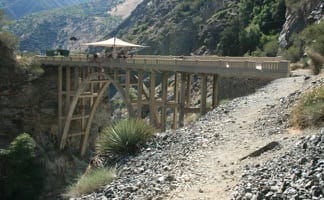

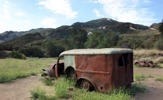
 This adventurous 10-mile round trip hike follows and crosses a river to an abandoned and out-of-place bridge with a unique history.
Wet adventure!
US
Trailhead coordinates: 34.23696, -117.765119 (34° 14′ 13.05″N 117° 45′ 54.42″W)
Park Headquarters: (626)574-1613
Access Fee: $Adventure Pass
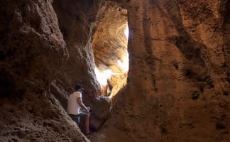
 This 2.1-mile loop features a cave to explore and a summit to top.
Coolest cave!
US
Trailhead coordinates: 34.195322, -118.658543 (34° 11′ 43.15″N 118° 39′ 30.75″W)
Park Headquarters: 805 370-2301
Access Fee: $0
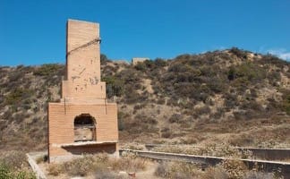
 This 5.8-mile hike visits a historic railway and ruins from a century old resort overlooking Pasadena.
Great ruins, views, and workout!
US
Trailhead coordinates: 34.20405, -118.1306 (34° 12′ 14.58″N 118° 07′ 50.16″W)
Park Headquarters: (626)574-1613
Access Fee: $0
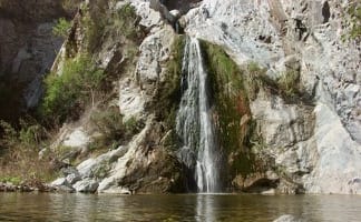
This 3.8-mile out and back visits a 200-foot waterfall that is split into two tiers. The upper tier is 150 feet tall and stunning after a rainstorm.Tallest waterfall!

US
Trailhead coordinates: 34.0261, -118.78 (34° 01′ 33.95″N 118° 46′ 48″W)
Park Headquarters: (323) 221-9944
Parking Fee: $12
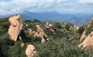
This 4.8-mile round trip hike starts ominously in an active rock quarry, but then progresses up a beautiful canyon to a mesmerizing multi-tiered waterfall.Charming canyon!
US
Trailhead coordinates: 34.15676, -117.92368 (34° 09′ 24.33″N 117° 55′ 25.24″W)
Park Headquarters: (626) 574-1613
Entrance Fee: $0
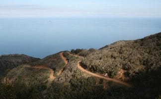
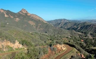
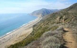
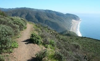 This 11.75-mile hike explores Point Mugu State Park on the west end of the Santa Monica Mountains, offering extraordinary mountain and ocean views.
Great long coastal hike!
US
Trailhead coordinates: 34.086245, -119.03676 (34° 05′ 10.48″N 119° 02′ 12.33″W)
Point Mugu State Park Headquarters: (310) 457-8144
Entrance Fee: $12
 This hike visits the preserved site where the exteriors of the television show MASH were filmed, a 4.75-mile trek in Malibu Creek State Park.
Cinematic scenery!
US
Trailhead coordinates: 34.0964, -118.71673 (34° 05′ 47″N 118° 43′ 00.2″W)
Park Headquarters: (310) 457-8144
Entrance Fee: $12
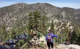
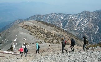 This 11.3-mile hike incorporates the Devil’s Backbone and the Baldy Bowl – Ski Hit Trail into one see-all loop to the summit that towers over the San Gabriels.
Highest summit!
US
Trailhead coordinates: 34.266172, -117.62684 (34° 15′ 58.21″N 117° 37′ 36.62″W)
Park Headquarters: (626)574-1613
Access Fee: $Adventure Pass
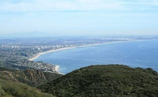
This 6-mile loop delivers the biggest views over the west end of the Santa Monica Mountains.Tallest mountain in the range!
US
Trailhead coordinates: 34.1116, -118.9268 (34° 06′ 41.8″N 118° 55′ 36.5″W)
Circle X Ranger Station in the Santa Monica Mountains National Recreation Area: 805 370-2301
Free parking: $0
This 9.5-mile loop visits two peaceful creeks in sylvan canyons, passing a 60-foot waterfall and plenty of beautiful wilderness.Beautiful canyons and waterfall!
US
Trailhead coordinates: 34.1955, -118.0225 (34° 11′ 43.8″N 118° 01′ 21″W)
Park Headquarters: (626) 574-1613
Access Fee: $Adventure Pass
 This 11.75-mile hike over the ridges above Avalon offers amazing ocean views, in two directions at times, as well as a look at the pristine interior of the island.
Scenic island hike!
US
Trailhead coordinates: 33.3424, -118.32495 (33° 20′ 32.6″N 118° 19′ 29.8″W)
Park Headquarters: (310) 510-2595
Access Fee: $0
 This hike extends a loop over Mount Waterman by dropping across a saddle and ascending Twin Peaks East, a panoramic summit at the center of the San Gabriel Mountains.
You’ll be tired!
US
Trailhead coordinates: 34.3465, -117.921 (34° 20′ 47.39″N 117° 55′ 15.60″W)
Park Headquarters: (626) 574-1613
Access Fee: $Adventure Pass
Honorable Mentions
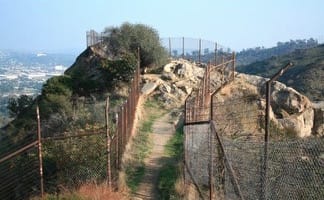
This hive-shaped point on the east side of Griffith Park is reached via a 1.7 to 4-mile round trip hike.Starts by an odd and interesting abandoned zoo!
US
Trailhead coordinates: 34.131, -118.284 (34° 07′ 51.6″N 118° 17′ 02.4″W)
Park Headquarters: (323) 644-2050
Access Fee: $0
This hike starts up Calabasas – Cold Creek Trail, a single track formerly know as the Secret Trail, passing great scenery on the way to the summit.Panoramic!

US
Trailhead coordinates: 34.12637, -118.657407 (34° 07′ 34.93″N 118° 39′ 26.66″W)
Park Headquarters: (323) 221-9944
Access Fee: $0
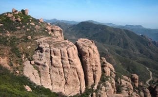
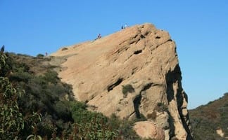 This loop takes Musch Trail and Eagle Springs Fire Road to visit a unique sandstone summit in Topanga State Park.
This rocks!
US
Trailhead coordinates: 34.0933, -118.5874 (34° 05′ 35.87″N 118° 35′ 14.64″W)
Topanga State Park Headquarters: (310) 455-2465
Access Fee: $
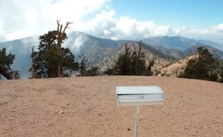 This hike climbs one of the tallest summits in the San Gabriel Mountains and a monument to Lord Baden-Powell, a BSA icon and the founder of the Scout Movement.
High views!
US
Trailhead coordinates: 34.372947, -117.752282 (34° 22′ 22.60″N 117° 45′ 08.21″W)
Park Headquarters: (626) 574-1613
Access Fee: $Adventure Pass
This hike takes the Backbone Trail from Piuma Trailhead in Malibu Creek State Park up to a subtle summit overlooking the Pacific.Canyon and ocean views!
US
Trailhead coordinates: 34.07994, -118.7038 (34° 04′ 47.8″N 118° 42′ 13.7″W)br />Park Headquarters: (310) 457-8144
Entrance Fee: $12
This lollipop loop up Stough Canyon in the Verdugo Mountains passes the ruins of an abandoned camp with views across the San Fernando Valley.Cool ruins!
US
Trailhead coordinates: 34.213328, -118.30705 (34° 12′ 47.98″N 118° 18′ 25.37″W)br />Stough Canyon Nature Center: (818) 238-5440
Entrance Fee: $0
 This hike from Paseo Miramar or Los Liones Drive rewards the effort with views of the Pacific Ocean en route to an overlook perched above Santa Monica Bay.
Oh hey, Santa Monica Bay!
US
Trailhead coordinates: 34.0508, -118.5571 (34° 03′ 02.88″N 118° 33′ 25.56″W)
Topanga State Park Headquarters: (310) 455-2465
Access Fee: $0
 This 7.5-mile hike combines Stunt High Trail and a section of the Backbone Trail to reach the 6th tallest summit in the Santa Monica Mountains.
Lofty Malibu summit!
US
Trailhead coordinates: 34.09505, -118.64855 (34° 05′ 42.2″N 118° 38′ 54.8″W)
Santa Monica Mountains National Recreation Area Headquarters: (805) 370-2301
Access Fee: $0
This 2.7 to 3.5-mile hike takes in tremendous views of the Pacific from a ridge above Big Sycamore Canyon in Point Mugu State Park.Dramatic oceanfront ridge!
US
Trailhead coordinates: 34.071305, -119.012668 (34° 04′ 16.69″N 119° 00′ 45.60″W)
Point Mugu State Park Headquarters: (310) 457-8144
Entrance Fee: $12
This 1.6 to 5.1-mile hike offers spectacular views of the Pacific from a less-visited park between Topanga and Malibu.Amazing coastal views!
US
Trailhead coordinates: 34.059538, -118.616345 (34° 03′ 34.33″N 118° 36′ 58.84″W)
Park Headquarters: (323) 221-9944
Access Fee: $0

My parents are coming to LA in 2 weeks and I want to show them the best it has to offer which includes hikes My parents are mid-50s but they are from the midwest where hiking is fairly flat, so I am worried about big elevation changes / moderate-difficult hikes. I do want a hike with ocean views, is scenic, maybe 1.5-3 miles, that is fairly easy. Any ideas on good spots? I was thinking of doing a test run this weekend somewhere – hoping to find something on west side (malibu, santa monica mountains, etc.)
They may really enjoy the hike to the MASH Site in Malibu Creek State Park. For a level hike on the coast, Malibu Lagoon may be just what you’re looking for.