Hikes in the Sierra Nevada Mountains
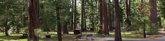
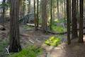
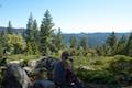
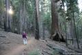
One magnificent mountain range covers much of the center of California, running 400 miles from north to south. Yosemite National Park, Kings Canyon National Park, and Sequoia National Park all lie within the Sierra Nevada Mountains, as well as a patchwork of other state and federally protected lands. This land seems made for hiking, with pristine meadows, giant sequoia forests, clear lakes, gushing rivers, and towering peaks. Choose a trail from the list below and explore the Sierra Nevada Mountains.
Highlights of the Sierra Nevada


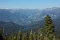
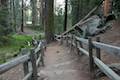
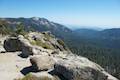
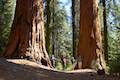
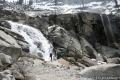
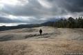
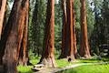
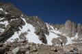
The tallest peaks are located on the east side of the Sierra Nevada Mountains. The highest point in the lower 48 states, Mount Whitney rises to 14,505 feet, and is one a dozen 14ers in the High Sierra. The Sierra Nevada Mountains contain all of the world’s natural groves of giant sequoias, including the world’s largest tree, the General Sherman Tree. North America’s tallest waterfall, Yosemite Falls, is another feature in this incredible mountain range.
Hiking the Sierra Nevada Mountains
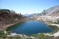
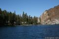
This collection of trails in the Sierra Nevada Mountains lists hikes from north to south and west to east. The table may also be sorted alphabetically or by distance to help you pick your next hike. Each trail links to its own report complete with photos, maps, directions, and all the other information needed to locate and enjoy these trails. An interpretive map is also provided.
| Trail | Description | Distance | Location |
|---|---|---|---|
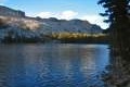
 020 020 | Moraine Trail to Fallen Leaf Lake This short loop sets out from Fallen Leaf Campground in South Lake Tahoe to visit a forest creek and a gorgeous mountain lake. | 1.1 miles 35 feet | 38.92348, -120.0547 |
 050 050 | North Grove - Big Trees Trail This easy loop in Calaveras Big Trees State Park explores the first giant sequoias discovered by settlers in California. | 1.5 miles 25 feet | 38.278071, -120.309392 |
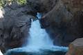
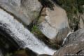
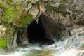 060 060 | Upper Natural Bridge Trail This fun hike visits a limestone tunnel (that you can swim through) in a creek in Calaveras County. | 2 miles 300 feet | 38.052011, -120.471381 |
 070 070 | Dragoon Gulch Trail This loop follows a creek and up a ridge to views over Sonora. | 2.5 325 feet | 37.982397, -120.39055 |
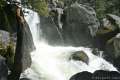
 150 150 | Wapama Falls This level hike tours the reservoir in Hetch Hetchy Valley to a thundering waterfall in the northwest corner of Yosemite National Park. | 5 miles 200 feet | 37.946905, -119.787376 |
 160 160 | May Lake This short east hike visits a peaceful alpine lake in the high elevation region of Yosemite National Park north of Yosemite Valley. | 2.4 miles 475 feet | 37.832633, -119.49118 |
 170 170 | Mirror Lake Park This easy hike reaches a relaxing reflective pool on the east end of Yosemite Valley. | 2 to 2.8 miles 100 feet | 37.739208, -119.56015 |
 177 177 | Happy Isles This short, easy hike explores a pair of islands in the Merced River at the east end of Yosemite Valley. | 0.75 miles 50 feet | 37.7324, -119.5598 |
 180 180 | Half Dome This epic hike climbs from Yosemite Valley to the top of the most iconic crest in the Yosemite Landscape. | 16 miles 4,800 feet | 37.732567, -119.558282 |
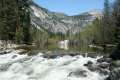
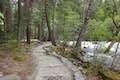
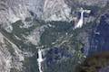
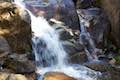
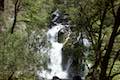
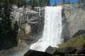 190 190 | Mist Trail This exciting trail climbs the Merced River past Vernal Fall and Nevada Fall, two of the prize waterfalls in Yosemite National Park. | 1.8 to 6.1 miles 400 to 1,925 feet | 37.732567, -119.558282 |
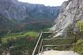
 200 200 | Panorama Trail This hike travels from Glacier Point down to Yosemite Valley in the most scenic way possible, ending with the Mist Trail. | 9.4 miles (one-way) 3,200 feet | 37.727942, -119.573476 |
 205 205 | Glacier Point This 7,214-foot overlook towers above Yosemite Valley and provides incredible drive-up views. | 0.5 miles 50 feet | 37.727103, -119.574456 |
 206 206 | Washburn Point This Glacier Point adjacent overlook offers views of Half Dome, Vernal and Nevada Falls, and mountains in the Clark Range. | 0 miles | 37.7204, -119.5730 |
 207 207 | Columbia Rock This hike up the start of Yosemite Falls Trail reaches a perch with a sweeping perspective across Yosemite Valley. | 2.2 miles 985 feet | 37.7423, -119.6021 |
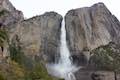 208 208 | Yosemite Falls Trail This hike rises above Columbia Rock to attain unforgettable views of Upper Yosemite Fall. | 3.5 to 7.1 miles 1,210 to 2,715 feet | 37.7423, -119.6021 |
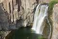
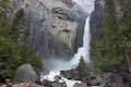 210 210 | Lower Yosemite Fall This electrifying loop in Yosemite Valley delivers visitors to the base of the tallest waterfall in North America. | 1.2 miles 100 feet | 37.745347, -119.594777 |
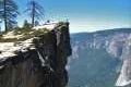 220 220 | Taft Point This out and back hike visits an overlook on the south wall of Yosemite Valley with fascinating rock fissures carved into the exposed granite. | 2 miles 250 feet | 37.7126, -119.586318 |
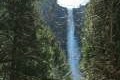 230 230 | Bridalveil Fall This easy paved trail visits the base of a 620-foot single-drop waterfall on the south side of Yosemite Valley. | 0.5 miles 50 feet | 37.7168, -119.651 |
 233 233 | Wildcat Falls This short path finds a secluded cascade along El Portal Road near the Arch Rock Entrance of Yosemite National Park. | 0.15 miles 15 feet | 37.7215, -119.7151 |
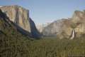 240 240 | Tunnel View Pull the car over at this extraordinary must see viewpoint looking up Yosemite Valley. | 0 miles | 37.715476, -119.67678 |
 250 250 | Chilnualna Falls This out and back hike begins near raucous cascades and ends atop a waterfall in southern Yosemite National Park. | 8 miles 2,200 feet | 37.54839, -119.63369 |
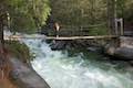 255 255 | Wawona Swinging Bridge This hike leads to a suspension bridge spanning a charming stretch of the South Fork Merced River in the Wawona Area of Yosemite National Park. | 0.8 to 1.4 miles 40 to 70 feet | 37.54637, -119.63015 |
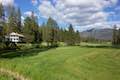 260 260 | Wawona Meadow Loop Trail This gentle hike passes through forest encircling a verdant, mostly-natural meadow near Wawona Hotel at the south end of Yosemite National Park. | 3.9 miles 250 feet | 37.53441, -119.6499 |
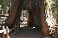 270 270 | Mariposa Grove This hike explores the biggest trees in Yosemite National Park, which can be seen on foot or by tram. | 1.6 to 8 miles 400 to 1,200 feet | 37.501462, -119.610862 |
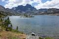
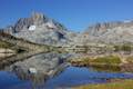 300 300 | Thousand Island Lake This exceptional lake is a true gem of the Sierra, reached via a section of Pacific Crest Trail through Ansel Adams Wilderness near Mammoth Lakes. | 18 miles 1,515 feet | 37.682865, -119.0847 |
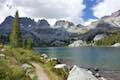
 310 310 | Shadow Lake This hike crosses a picturesque canyon and passes a plunging cascade to visit a mountain lake in Ansel Adams Wilderness near Mammoth Lakes. | 8.5 miles 750 feet | 37.682, -119.086 |
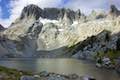
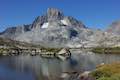
 315 315 | Ediza Lake This hike ventures above Shadow Lake along a creek to a beautiful lake below Mount Ritter and Banner Peak. | 15 miles 1,250 feet | 37.682, -119.086 |
 320 320 | Iceberg Lake This short extension off the trail to Ediza Lake heads to a higher lake in a sublime setting below a ridge of steep spires called the Minarets. | 1 mile (extension) 510 feet | 37.682, -119.086 |
 325 325 | Garnet Lake This beautiful lake along John Muir Trail lies between Shadow Lake and Thousand Island Lake, making it an ideal stop on a backpacking loop. | 17.1 miles 2,070 feet | 37.682, -119.086 |
 330 330 | Ediza Lake - Thousand Island Lake Loop This multi-day trek incorporates sections of John Muir Trail and Pacific Crest Trail to visit a series of stunning Sierra lakes in the Ansel Adams Wilderness of Inyo National Forest. | 25 miles 2,110 feet | 37.682, -119.086 |
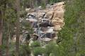 340 340 | Minaret Falls This out and back hike from Devils Postpile National Monument connects with Pacific Crest Trail to reach the base of a waterfall that tumbles and slides down a rocky slope. | 3 miles 125 feet | 37.6299, -119.0847 |
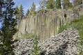 350 350 | Devils Postpile This hike visits the columnar basalt cliff that Devils Postpile National Monument is named after, with top-down and bottom-up views of the impressive formation. The hike can be extended to include Rainbow Falls at the south end of the monument. | 1 to 1.35 miles 40 to 215 feet | 37.6299, -119.0847 |
 360 360 | Rainbow Falls This hike passes the Devils Postpile Formation to reach an attractive 101-foot waterfall with rainbows in its mist. | 5.1 to 5.25 miles 325 to 435 feet | 37.6299, -119.0847 |
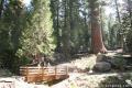
 400 400 | Bull Buck Tree Trail This easy loop leaves from Nelder Grove Campground and leads to a single giant sequoia with an incredibly broad base. | 0.8 miles 120 feet | 37.4301, -119.5831 |
 410 410 | Big Ed Tree Trail This hike is quite short, but visits a tree that is quite big - part of the Nelder Grove of Giant Sequoias in Sierra National Forest. | 0.2 miles 25 feet | 37.4296, -119.58614 |
 420 420 | Shadow of the Giants Trail This nature trail loop visits giants sequoias and imparts wisdom about the great trees and their surroundings. | 1.1 miles 200 feet | 37.4262, -119.5962 |
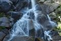
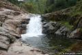
 430 430 | Lewis Creek Trail to Corlieu Falls This hike passes down along a rushing creek to a viewing platform in front of an enthusiastic, cascading waterfall. | 0.8 miles 275 feet | 37.41662, -119.6266 |
 440 440 | Way of the Mono Trail This interpretive trail rises to a granite perch with grand views over Bass Lake and the surrounding Sierra. | 0.6 miles 140 feet | 37.3219, -119.5781 |
 500 500 | Grizzly Falls This stroll at Grizzly Falls Picnic Area reaches the base of an 80-foot waterfall in Sequoia National Forest, located along Generals Highway near the Cedar Grove Area of Kings Canyon National Park. | 0.1 miles 10 feet | 36.802979, -118.743561 |
 510 510 | Roaring River Falls This paved out and back hike reaches a thundering little waterfall on a tributary of the Kings River in Kings Canyon National Park. | 0.3 miles 25 feet | 36.783747, -118.622121 |
 520 520 | Kanawyer Loop Trail This loop is scenic and easy, exploring east from the backcountry gateway at Road's End along both sides of the South Fork Kings River in in Kings Canyon National Park. | 5 miles 125 feet | 36.794663, -118.582941 |
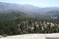
 530 530 | Panoramic Point This short out and back hike reaches an exception overlook with views into Kings Canyon. | 0.5 miles 100 feet | 36.753793, -118.946754 |
 540 540 | North Boundary Trail This lollipop loop hike starts on the trail between Grant Grove and Grant Village and passes the General Grant Tree to reach a 2.75-mile loop through the pine forest north of Grant Grove in Kings Canyon National Park. | 3.55 miles 375 feet | 36.746811, -118.972595 |
 550 550 | General Grant Tree Trail This loop in the Grant Grove in Kings Canyon National Park passes through a Fallen Monarch to reach the General Grant Tree, one of the world's largest sequoias. | 0.8 miles 50 feet | 36.747, -118.973128 |
 560 560 | North Grove Trail This loop explores a quiet grove of sequoias in Kings Canyon National Park near the crowded Grant Grove and can combine with Dead Giant Loop Trail for 3.25-mile hike. | 2 miles 350 feet | 36.747103, -118.974642 |
 570 570 | Dead Giant Loop Trail This loop passes a small meadow and a large dead sequoia to reach Sequoia Lake Overlook and can combine with nearby North Grove Trail for 3.25-mile hike in Kings Canyon National Park | 2.25 miles 300 feet | 36.747103, -118.974642 |
 580 580 | Grant Village to Grant Grove Trail This mile-long trail connects the visitor center at Grant Village in Kings Canyon National Park with the parking lot at Grant Grove, passing through Azalea Campground to reach giant sequoias, including the General Grant Tree. | 2 miles 250 feet | 36.740049, -118.963588 |
 590 590 | Buena Vista Peak This out and back hike reaches a granite summit with 360-degree views over the Redwood Mountain Grove and Kings Canyon. | 2 miles 420 feet | 36.718234, -118.896935 |
 600 600 | Hart Tree and Fallen Goliath Loop This loop on Hart Tree Trail and Redwood Creek Trail passes tranquil streams and interesting sequoias in the Redwood Mountain Grove in Kings Canyon National Park. | 8.3 miles 925 feet | 36.707444, -118.92093 |
 610 610 | Tokopah Falls This gradual out and back hike visits the tallest waterfall in Sequoia National Park. | 4.2 miles 630 feet | 36.6048, -118.7249 |
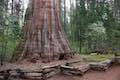
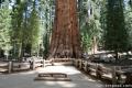 620 620 | General Sherman Tree This paved out at back hike in Sequoia National Park visits the world's biggest tree. | 1 mile 200 feet | 36.5848, -118.74984 |
 640 640 | Congress Loop This easy paved loop in Sequoia National Park visits the fourth and fifth tallest Sequoias in the world (among others). | 2 miles 230 feet | 36.5848, -118.74984 |
 650 650 | Sunset Rock This out and back hike in Sequoia National Park visits a large granite dome with great views to the west. | 2 miles 50 feet | 36.5657, -118.7724 |
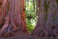
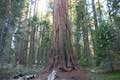
 660 660 | Big Trees Trail This easy, educational, and beautiful loop explores the giant sequoias around Round Meadow in Sequoia National Park. | 1.4 miles 50 feet | 36.564866, -118.773736 |
 670 670 | Beetle Rock This short walk in Sequoia National Park goes from the Giant Forest Museum to Beetle Rock visits a granite dome with great views and stunning sunsets. | 0.25 miles 50 feet | 36.5647, -118.77425 |
 680 680 | Crescent Meadow This level loop in Sequoia National Park visits a Sequoia you can stand inside (Chimney Tree) and another that someone used to live in (Tharp's Log). | 1.6 miles 150 feet | 36.5548, -118.7490 |
 690 690 | Sugar Pine and Bobcat Point Trails Loop This short but diverse loop in Sequoia National Park peaks at Bobcat Point, which presents a fierce perspective of Moro Rock and a massive canyon. | 1.5 miles 250 feet | 36.5548, -118.7490 |
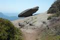 700 700 | Hanging Rock This short out and back hike in Sequoia National Park passes views of Moro Rock en route to a balancing boulder on a canyon rim at the edge of the Giant Forest. | 0.35 miles 100 feet | 36.549128, -118.768186 |
 710 710 | Moro Rock This short out and back hike (with a lot of stairs) sports panoramic views and should be considered a mandatory hike for first time visitors to Sequoia National Park. | 0.6 miles 300 feet | 36.5469, -118.7656 |
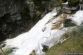 720 720 | Marble Falls This out and back hike takes a flower-lined path up a mountain canyon to a powerful waterfall in Sequoia National Park. | 8 miles 2,150 feet | 36.51785, -118.80115 |
 730 730 | Paradise Creek This short stroll leaves Buckeye Flat Campground to visit the perfect swimming hole for a hot summer day in Sequoia National Park. | 0.5 to 6 miles 75 feet | 36.52185, -118.76352 |
 740 740 | Panther Creek This out and back hike follows the Middle Fork Trail to a 100 foot waterfall into the Middle Fork of Kaweah River in Sequoia National Park. | 6 miles (or farther) 600 feet | 36.52755, -118.7513 |
 750 750 | Hockett Trail This out and back hike descends through sequoias to East Fork Kaweah River and farther into the backcountry of the Mineral King area of Sequoia National Park. | 3 to 5 miles (or farther) 600 feet | 36.46424, -118.6690 |
 760 760 | Monarch Lakes This out and back hike visits a spectacular pair of lakes high above Mineral King Valley in Sequoia National Park. | 9.4 miles 2,500 feet | 36.45305, -118.59665 |
 780 780 | Eagle Lake The out and back hike climbs the west side of Mineral King Valley to a high-elevation lake in Sequoia National Park. | 7.2 miles 2,200 feet | 36.4488, -118.5954 |
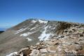
 850 850 | Mount Pickering This 13,485-foot summit in Sequoia National Park rises above Sky Blue Lake to offer sweeping views of the Sierra. | 30 miles 3,500 feet | 36.527133, -118.290875 |
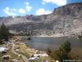
 860 860 | Sky Blue Lake This hike extends beyond Lower Soldier Lake up Miter Basin to a deep blue lake surrounded by 14,000-foot peaks. | 26 miles 2,350 feet | 36.532788, -118.273494 |
 870 870 | Primrose Lake This trek visits a lake off the side of Miter Basin near Sky Blue Lake and below Mount Pickering in Sequoia National Park. | 28 miles 2,350 feet | 36.521144, -118.276173 |
 880 880 | Mount Langley This trek travels past Cottonwood Lakes Trail over New Army Pass to a 14,042-foot summit with towering views of the Sierra. | 22 miles 4,000 feet | 36.4532, -118.1699 |
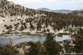
 890 890 | Lower Soldier Lake This 19.2-mile loop crosses Cottonwood Pass and New Army Pass to visit a beautiful lake that is an ideal camping spot for backpackers heading higher and deeper into the Sierra. | 17.6 to 20.8 miles 1,500 to 2,350 feet | 36.503604, -118.269331 |
 900 900 | Cirque Peak This 12,900-foot summit in Inyo National Forest can be reached via off-trail ascents from New Army Pass, Cirque Lake, and Chicken Spring Lake. | 13 to 19 miles 2,900 feet | 36.476732, -118.237023 |
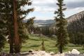
 910 910 | Cottonwood Lakes This scenic trail in Inyo National Forest provides a day hike through a lake-filled basin and access to New Army Pass, a 12,300-foot pass on the border of Sequoia National Park. | 10 to 15 miles 1,400 to 2,350 feet | 36.4532, -118.1699 |
 920 920 | Old Cottonwood Creek Trail This hike in Inyo National Forest follows a secluded trail through mountain meadows to the South Fork Lakes and Cirque Lake. | 8 to 9 miles 1,150 feet | 36.4532, -118.1699 |
 930 930 | Chicken Spring Lake This hike in Inyo National Forest continues past Cottonwood Pass to an alpine lake that makes a nice day hike destination or a good first camp for backpackers. | 8.2 miles 1,330 feet | 36.44834, -118.17065 |
 940 940 | Cottonwood Pass This trail leaves Horseshoe Meadow for an 11,200-foot pass and a junction with the Pacific Crest Trail, with access to Golden Trout Wilderness and Sequoia National Park. | 7 miles 1,200 feet | 36.44834, -118.17065 |
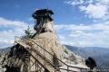 950 950 | Needles Lookout This out and back hike visits a fire tower with unbeatable views over Sequoia National Forest. | 5 miles 500 feet | 36.1198, -118.5084 |
 960 960 | Dome Rock This short out and back hike just off Western Divide Highway in Sequoia National Forest provides a great view of the valley below. | 0.5 miles 75 feet | 36.068, -118.532 |
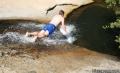 970 970 | Natural Water Slide This out and back hike visits a refreshing natural water slide on the eastern side of the Great Western Divide in Sequoia National Forest. | 1.5 mile 150 feet | 36.02745, -118.5153 |
 980 980 | Trail of 100 Giants This paved loop explores a grove of giant sequoias alongside Western Divide Highway in Sequoia National Forest. | 1.3 miles 80 feet | 35.97733, -118.59399 |