New Zealand
Hello (or Kia Ora)! Hikespeak.com is building a new section full of hiking tracks, campgrounds, lodging, and other outdoor fun in New Zealand. Much of New Zealand’s great outdoors area protected by the Department of Conservation (DOC), including fourteen national parks. Entry to every park in New Zealand is free, and the country is a great destination for hiking. The scenery is incredible and the hiking trails (called walking or tramping tracks) are impeccably maintained.
New Zealand is made up of two large islands, the North Island and the South Island, as well as several smaller islands. Most of the population lives on the North Island, while the grandest mountains, the Southern Alps, run down the South Island. New Zealand’s islands are divided into several regions for governing and tourism. There are nine regions on the North Island and seven regions on the South Island. While not as distinct as states, each region does have some autonomy. Read more about New Zealand’s regions.
Hiking Tracks in New Zealand
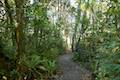
This collection of walking tracks (hiking trails) in New Zealand is listed from north to south and west to east. The table may also be sorted alphabetically or by distance to help you pick your next hike. There is also a search feature, which can be used to quickly isolate the hike you are looking for. Each track links to its own report complete with photos, maps, directions, and all the other information needed to locate and enjoy these hikes.
| Trail | Description | Distance | Location |
|---|---|---|---|
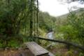
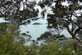 030 030 | Watkin Powell Track This short track crosses through bush to reach a secluded beach in Tauwhara Bay where you can continue walking up the coast. | 0.33 km 20 meters | -35.4919, 174.45937 |
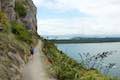 90 90 | Mount Maunganui This trek combines picturesque tracks around the base and up to the summit of a peninsula-topping peak in the Bay of Plenty Region of New Zealand. | 3.4 - 7.3 km 20 - 230 meters | -37.63345, 176.1747 |
 100 100 | Kakepuku Track This trek in Kakepuku Mountain Historic Reserve near Te Awamutu ascends to a 449-meter summit with a lookout tower boasting panoramic views. | 8 km 407 meters | -38.0781, 175.2625 |
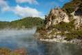
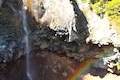
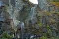
 130 130 | Okere Falls Track This scenic walk through Okere Falls Scenic Reserve has views of multiple waterfalls, cascades, and pools on the Okere River near Rotorua. | 3 km 55 meters | -38.01424, 176.34396 |
 135 135 | Blue Lake This circuit near Rotorua provides a pleasant loop across lakeside beaches and forests, rising to a lookout over Blue Lake and nearby Green Lake. | 6.15 km 40 meters | -38.1875, 176.332 |
 138 138 | Waimangu Volcanic Valley This route descends through a landscape of spectacular geothermal features like Frying Pan Lake, the largest hot spring in the world, and can be paired with Lake Rotomahana Boat Cruise for a memorable geothermal experience in Rotorua. | 4.75 km 115 meters | -38.2857, 176.387 |
 140 140 | Crater Lake This short walk in Rainbow Mountain Scenic Reserve goes to an overlook with views of a turquoise pool below vibrant cliffs. | 1 km 18 meters | -38.3154, 176.3759 |
 142 142 | Kerosene Creek This short walk follows Kerosene Creek down to a hot pool below a crescent-shaped waterfall. Bring your bathing suit and wade into warm, welcoming waters. | 0.33 km 14 meters | -38.33425, 176.38613 |
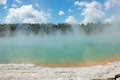 145 145 | Wai-O-Tapu Thermal Wonderland This thermal area full of hot pools, geysers, fumaroles, and mud pots can be explored on three successive loops. | 1.35 - 3.05 km 20 meters | -38.35573, 176.3674 |
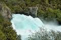 160 160 | Spa Thermal Park - Huka Falls Walkway This walk follows the Waikato River from hot springs at Spa Thermal Park to the rapids and waterfall at Huka Falls in New Zealand's most visited scenic reserve. | 7.3 km 45 meters | -38.6729, 176.08835 |
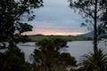
 170 170 | Lake Rotopounamu This lollipop loop visits tranquil beaches on a forest-wrapped lake in Tongariro National Park. | 6.4 km 90 meters | -39.01716, 175.73165 |
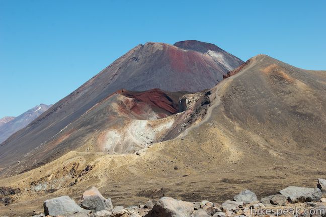
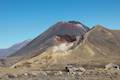 180 180 | Tongariro Alpine Crossing This through-hike ventures across dynamic volcanic landscapes in Tongariro National Park and ranks among the world's greatest day hikes. | 19.4 km 1125 meters | -39.144398, 175.580942 |
 183 183 | Tawhai Falls This out and back return hike visits a short but enticing single-drop waterfall near Whakapapa Village in Tongariro National Park. | 0.8 km 40 meters | -39.175314, 175.5136 |
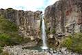 185 185 | Taranaki Falls This loop crosses a variety of volcano-influenced landscapes to reach a beautiful 20-meter tall waterfall in Tongariro National Park. | 6.45 km 115 meters | -39.19955, 175.5429 |
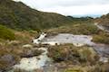 188 188 | Silica Rapids This track leaves from Whakapapa Village in Tongariro National Park and crosses alpine bogs, forests, streams, and ridges of volcanic rock to reach creamy cascades on silica terraces. | 5.15 - 7.15 km 190 meters | -39.2036, 175.54015 |
 195 195 | Mangawhero Falls This short, easy hike leads to a viewpoint for a 25-meter tall waterfall below Mount Ruapehu in Tongariro National Park. | 0.3 km 10 meters | -39.319218, 175.502732 |
 196 196 | Waitonga Falls This out and back return hike reaches Tongariro National Park's tallest waterfall and passes through an alpine wetland that reflect views of Mount Ruapehu. | 4 km 110 meters | -39.32958, 175.49579 |
 198 198 | Rimu Walk This short, level walk explores a Rimu forest along the Mangawhero River near the town of Ohakune at the south end of Tongariro National Park. | 0.8 km 8 meters | -39.39984, 175.41498 |
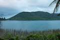
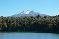 200 200 | Lake Rotokura This out and back return hike reaches a peaceful blue lake that reflects a view of Mount Ruapehu, the tallest mountain on the North Island. | 2 km 75 meters | -39.437782, 175.519195 |
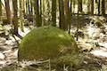 250 250 | Whitecliffs Boulders This walk goes through sheep pastures and down cliffs by the Rangitikei River to a small forest filled with large spherical boulders that are quite unique. | 4.1 km 140 meters | -39.8483, 175.7664 |
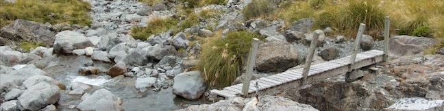
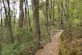
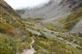 600 600 | Otira Valley Track This out and back return hike ventures up a valley on the north side of Arthur's Pass, finding a footbridge over Otira River and broad views of surrounding mountains. | 3.8 km 125 meters | -42.8986, 171.5587 |
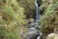
 605 605 | Bealey Chasm Walk This short walk passes through moss-covered beech trees to a bridge over Bealey River where it slips through a ravine. | 0.65 km 12 meters | -42.9192, 171.5584 |
 610 610 | Jacks Hut to Bridal Veil Falls Lookout This hike on Arthur's Pass Walking Track crosses beech forests and alpine shrublands, dropping across a canyon to arrive at a view of Bridal Veil Falls. | 2.5 km 75 meters | -42.9196, 171.5586 |
 615 615 | Arthur's Pass Village to Bridal Veil Falls Lookout This hike up Arthur's Pass Walking Track takes a gradual approach to a viewpoint with a perspective of Bridal Veil Falls and surrounding mountains. | 1.8 km 68 meters | -42.9353, 171.56063 |
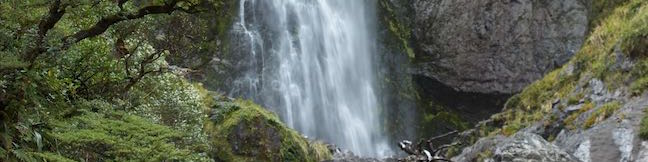
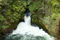
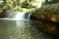
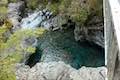
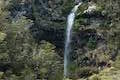
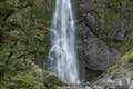 620 620 | Devils Punchbowl Falls This out and back return hike ascends to a viewing platform near the base of an impressive waterfall that should be a top priority for Arthur's Pass National Park visitors. | 2 km 90 meters | -42.9353, 171.56063 |
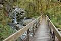
 625 625 | Millennium Walk to Avalanche Creek Waterfall This short walk goes from Arthur's Pass National Park Visitor Centre to a bridge and viewpoint below a waterfall on Avalanche Creek as it approaches Arthur's Pass Village. | 0.5 km 7 meters | -42.942, 171.5626 |
 630 630 | Old Coach Road Walk If you stay overnight at Greyneys Shelter Campground, start the day with this short loop that travels through the forest surrounding the campground along an old roadbed. | 1 - 1.4 km 15 meters | -42.9843, 171.5906 |
 640 640 | Kereru Loop This short loop combines Wooded Gully Track, Kereru Track, and Red Pine Track to slip through forest to a picnic spot next to Wooded Gully Stream in Mount Forest Thomas Conservation Area. | 2.45 km 95 meters | -43.1922, 172.3362 |
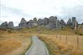 650 650 | Kura Tawhiti / Castle Hill Conservation Area This hike explores a fascinating jumble of limestone boulders close to Arthur's Pass National Park. | 2.6 km 65 meters | -43.23335, 171.7222 |
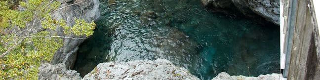
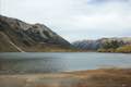
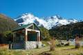
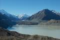 750 750 | Tasman Glacier View & Blue Lakes This pair of tracks form a short two-pronged hike with views of small emerald pools and a large milky lake below Tasman Glacier in Aoraki Mount Cook National Park. | 1.85 km 85 meters | -43.698, 170.16325 |
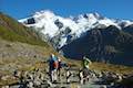
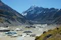 760 760 | Hooker Valley This extraordinary out and back return hike in Aoraki Mount Cook National Park makes its way up a valley surrounded by massive peaks to Hooker Lake, which is filled with icebergs originating from a glacier below Mount Cook. | 11 km 20 meters | -43.7187, 170.09315 |
 763 763 | Kea Point This easier return walk goes to landing above Mueller Lake with views of Mount Sefton and Mount Cook in Aoraki Mount Cook National Park. | 3 km 95 meters | -43.71875, 170.0926 |
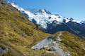 766 766 | Sealy Tarns This incredibly steep and incredibly scenic hike in Aoraki Mount Cook National Park uses a string of staircases to ascend a mountainside to pools that reflect views of Mount Sefton and Mount Cook. | 5.8 km 547 meters | -43.71875, 170.0926 |
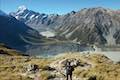 769 769 | Mueller Hut Ascend past Sealy Tarns on a rough route to a famed hut with spectacular views of Aoraki Mount Cook National Park. | 10.5 km 1,045 meters | -43.71875, 170.0926 |
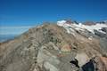 770 770 | Mount Ollivier This 1,933-meter tall summit can be reached by ascending above Mueller Hut for even grander views over in Aoraki Mount Cook National Park. | 11.7 km 1,170 meters | -43.71875, 170.0926 |
More outdoor fun
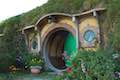 | Hobbiton Movie Set Tourist Farm Fantasy becomes reality when you visit the filming location for Hobbiton from The Lord of the Rings and The Hobbit. See Bag End, get a drink at Green Dragon Inn, and walk past hobbit hole after colorful hobbit hole on a tour through Hobbiton Movie Set. |
 | Kaituna River Whitewater Rafting Take a memorable trip down the Kaituna River (Okere River) through Okere Falls Scenic Reserve that includes a thrilling plunge over Tutea Falls, the tallest commercially rafted waterfall in the world! |
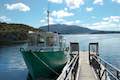 | Lake Rotomoahana Boat Cruise Take a boat tour over the lake at the bottom of Waimangu Volcanic Valley, getting close to steaming vents and geysers right along the lakeshore for a unique on-the-water experience. The cruise is reachable by bus or a hike down Waimangu Volcanic Valley. |
Campgrounds and Holiday Parks in New Zealand
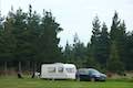
There are places to camp all over New Zealand, including Department of Conservation campgrounds and holiday parks that are usually run privately. Holiday Parks offer powered sites where campervans and RVs can plug in. They also offer kitchens and dining areas, bathrooms with showers, and other amenities. Most Department of Conservation campgrounds are fairly basic, but some offer extra amenities as well. There are also huts for backpacks throughout New Zealand’s parks. Pricing in New Zealand is done per person and not per site. Checkout time is typically 10 a.m. and you can check in in the afternoon.
 | Avalanche Creek Shelter Campground This 10-site campground in Arthur’s Pass Village has a large shelter and easy access to the park visitor center and nearby hiking tracks. |
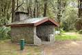 | Greyneys Shelter Campground Camping is free around this small 3-wall stone shelter along State Highway 73 south of Arthur’s Pass Village. |
 | Lake Pearson (Moana Rua) Campground This campground has about 20 sites along the shore of a peaceful lake between mountains in the Canterbury Region near Arthur’s Pass National Park. |
 | Mangawhero Campground This campground in Tongariro National Park near Ohakuna, New Zealand has twelves sites on two loops with views of Mount Ruapehu. |
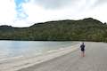
 | Otamure Bay Campground This 131-site campground lies between farm-covered hills and a charming beach framed by rocky points. |
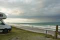 | Papamoa Beach Resort This oceanfront holiday park offers scenic lodging and campsites on grass-covered dunes above a beautiful beach on the Bay of Plenty near Tauranga. |
 | Rawene Holiday Park This holiday park offers tent sites, campervan sites, and cabins on a hill on a peninsula jutting into Hokianga Harbour in Northland, NZ. |
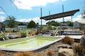 | Rotorua Top 10 This holiday park has campsites, cabins, and motel accommodations in a fun setting near the center of Rotorua with amenities that include mineral hot pools. |
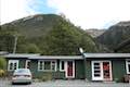
 | Whakapapa Holiday Park This holiday park in Whakapapa Village offers tent sites, campervan sites, cabins, and a backpackers lodge along a stream below Mount Ruapehu in Tongariro National Park. |
 | White Horse Hill Campground This 60-site campground is surrounded by great hiking tracks and just a few kilometers from Mount Cook Village, making it an ideal place to stay during a visit to Aoraki Mount Cook National Park. |
 | Wooded Gully Campground This broad campground with minimal amenities has grassy sites near the start of the hiking tracks into Mount Thomas Forest Conservation Area. |
Lodging in New Zealand
 | Arthur’s Pass Alpine Motel This lodging option in Arthur’s Pass Village offers self-contained cabin accommodations that are convenient for visiting Arthur’s Pass National Park. |
 | Matariki Motor Lodge This motor lodge in the town of Te Awamutu is halfway between Hobbiton and Waitomo with studio and one-bedroom units with lots of conveniences for travelers. |
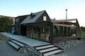
 | Murupara Motor Camp Set in a small town in the Bay of Plenty Region of New Zealand, this motor camp is half holiday park and half motor lodge, offering a variety of accommodations in a location that is both removed from busy tourist centers and close to lots of fun outdoor activities. |
 | Rathmoy Lodge This lodge along the Rangitikei River is in a beautiful country setting that is private, elegant, and comfortable. Relax in and around the lodge, go for a swim, or tackle one of the area’s adventures. |
 | Whakaipo Lodge This lodge near Lake Taupo blends comfort with luxury and has welcoming owners who can help you take advantage of the area’s abundant outdoor opportunities. |
Or explore hikes in New Zealand on the Oceania Hike Finder Map