Hikes in Death Valley National Park
Death Valley covers some 3,000 square miles and is the largest national park in the lower 48 states. Badwater Basin, the lowest point North America, is among the park’s many attractions.
Death Valley receives approximately two inches of rain per year and the thermometer-busting temperatures have set world records. Hiking in the extreme summer temperatures can be dangerous. Many campgrounds close during the summer months. Late fall and early spring are the best time to visit most of Death Valley’s attractions.
The park’s highest point, Telescope Peak, towers over Badwater Basin at a height of 11,049 feet. Trails in the higher elevation around Telescope Peak are better suited for summer visits.
Highlights of Death Valley National Park


What are the best hikes in Death Valley National Park?
The greatest hike in Death for you depends on what you’re looking for, and there are a lot of awesome options.
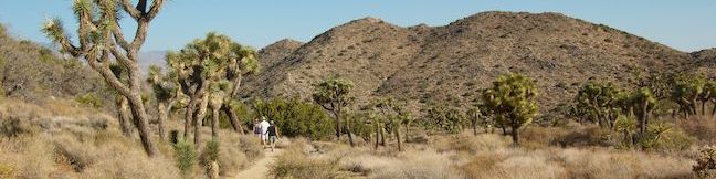
On your first visit to Death Valley, drop down to Badwater Basin and check out Artist’s Drive. Make your way up to Dante’s View and enjoy a sweeping overlook with a couple short trails. Stop by Zabriskie Point along the way and look out over the park’s badlands. If you like what you see, hike Badlands Loop or Golden Canyon – Gower Gulch Loop. Death Valley has several sand dunes. Mesquite Flat Sand Dunes are the easiest to explore. Mosaic Canyon offers a fun hike with interesting geology and Ubehebe Crater is like nothing else in the park. Death Valley has a lot of fun things to see and do!
Death Valley National Park Hiking
The trails and attractions below are listed from north to south and west to east. The outings may also be sorted alphabetically or by distance to help plan a trip to Death Valley. Each trail and attraction links to its own report complete with photos, maps, directions, and everything else needed to explore the park. You can also view hikes around Death Valley National Park on the Hike Finder Map.
| Trail | Description | Distance | Location |
|---|---|---|---|
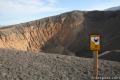 110 110 | Ubehebe Crater You can get a great view of Ubehebe Crater from an overlook near the parking lot, and there are also three trails to choose from. | 0 - 2 miles 0 - 275 feet | 37.0108, -117.4549 |
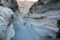 120 120 | Mosaic Canyon This out and back hike starts up a smooth marble slot canyon and exposes visitors to unique Death Valley geology. | 1 - 4 miles 100 - 750 feet | 36.57193, -117.14434 |
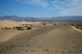 130 130 | Mesquite Flat Sand Dunes This hike explores the most visible sand dunes in Death Valley | 1 - 3 miles 100 feet | 36.6062, -117.1150 |
 140 140 | Grotto Canyon This out and back hike requires a bit of climbing and is a lesser-visited trail in Death Valley. | 2 - 4 miles 625 feet | 36.5823, -117.1041 |
 150 150 | Salt Creek This easy out and back hike crosses a short boardwalk bordering a rare desert stream. | 1 mile 25 feet | 36.5906, -116.9906 |
 160 160 | Harmony Borax This short walk around the Harmony Borax plant offers a window into the mining past of Death Valley. | 0.25 miles 25 feet | 36.48003, -116.87335 |
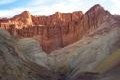 170 170 | Golden Canyon - Gower Gulch Loop This loop visits some of the most stunning terrain in Death Valley. | 4 miles 675 feet | 36.4207, -116.8467 |
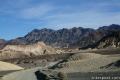
 180 180 | Badlands Loop This loop offers a great immersion into the terrain beneath Zabriskie Point. | 2.5 miles 300 feet | 36.42085, -116.8099 |
 190 190 | Zabriskie Point Zabriskie Point offers a stunning panorama of the badlands near Furnace Creek. | 0.25 miles | 36.42085, -116.8099 |
 200 200 | Twenty Mule Team Canyon This 2.8-mile one way road lets visitors experience a fine canyon right from the driver’s seat. | 0 miles | 36.40953, -116.7947 |
 210 210 | Artist’s Drive This 9-mile drive crosses a sloping mountainside composed of vibrant soil colored by rich metals. | 0 - 0.5 miles | 36.32995, -116.82995 |
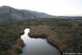
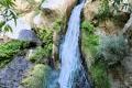 220 220 | Darwin Falls This out and back hike visits a refreshing year-round waterfall on the western edge of Death Valley. | 2 miles 275 feet | 36.32776, -117.51466 |
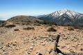 230 230 | Wildrose Peak This out and back hike summits a 9,064-foot peak in the Panamint Mountain Range on the west side of Death Valley. | 8.4 miles 2,200 feet | 36.2467, -117.0763 |
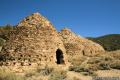 240 240 | Charcoal Kilns These conical constructions converted lumber to charcoal for area miners from 1879 to 1882. | 0 - 0.5 miles | 36.2467, -117.0763 |
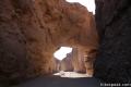 250 250 | Natural Bridge Canyon This is a great out and back hike for those interested in learning about the geological history of Death Valley. | 2 miles 400 feet | 36.28115, -116.7699 |
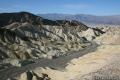
 260 260 | Badwater Basin This is the lowest place in North America -- a required stop for first time visitors to Death Valley. | 0 - 1 miles | 36.2301, -116.7671 |
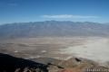 270 270 | Dante’s View This towering overlook above Badwater Basin offers panoramic views of Death Valley. | 0 - 1 miles 0 - 200 feet | 36.2206, -116.7266 |
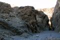
 280 280 | Sidewinder Canyon This out and back hike visits narrow slot canyons full of pour-overs, carve outs, and dark passages that beg to be explored. | 4 - 7 miles 500 - 750 feet | 36.0650, -116.7448 |
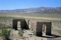 290 290 | Ashford Mill These ruins, where gold was once processed for the Ashford Mine, provide an example of how tough life can be in this harsh desert. | 0.1 miles | 35.9209, -116.6813 |
Or explore hikes around Death Valley National Park on the Hike Finder Map
Are you looking for other places to explore around Death Valley? The California desert has more great parks to visit, like: