Hikes in Rocky Mountain National Park

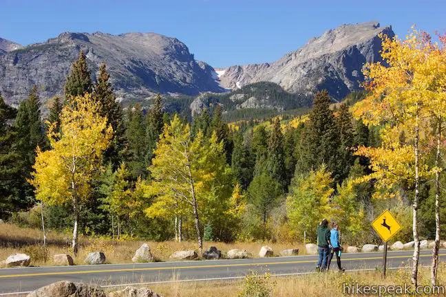
Covering 425 square miles of sylvan forests, pristine lakes, and soaring mountains along both sides of the Continental Divide, Rocky Mountain National Park is a welcoming park for hikers.

Longs Peak is the highest summit in the park and rises to 14,259 feet above sea level.

Rocky Mountain National Park is a popular destination during summer months and also during a special period in the fall. From mid-September to early October, the leaves of the park’s quaking aspen turn yellow, orange, and red, attracting many visitors. The elk rut (mating season) occurs at the same time, meaning that the park’s elk are more likely to be seen and heard (bugling).

Rocky Mountain National Park
Hallett Peak, Otis Peak, and Chaos Canyon above Bear Lake Road

Hiking Rocky Mountain National Park

Here are two of the many hiking trails in Rocky Mountain National Park. Both hikes begin from the Bear Lake Trailhead at the end of Bear Lake Road.

Bear Lake Trail
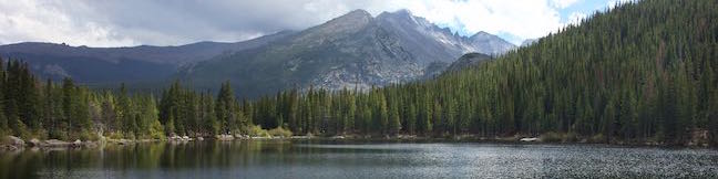
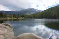
Bear Lake Nature Trail
This easy 0.65-mile hike takes a loop around Bear Lake in Rocky Mountain National Park, passing numerous views across the beautiful subalpine lake.
Emerald Lake Trail
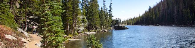
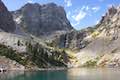
Emerald Lake Trail
This beautiful 3.6-mile hike tours a trio of lovely lakes in Rocky Mountain National Park, passing Nymph Lake and Dream Lake to find Emerald Lake cradled below 12,000-foot mountains and a glacier.


View Colorado trails and campgrounds in a larger map
Or explore hikes around Rocky Mountain National Park on the Hike Finder Map
hikespeak
Emerald Lake, Dream Lake, and Nymph Lake in Rocky Mountain National Park
Emerald Lake Trail visits a trio of beautiful mountain lakes in Rocky Mountain National Park, easing past Nymph Lake and Dream Lake on the way to Emerald Lake, which is cradled below 12,000-foot peaks along the Continental Divide. This three-lake hike is 3.6 miles round trip with 650 feet of elevation change. This scenic hike begins from Bear Lake Trailhead, where a fourth lake can added to the outing with Bear Lake Nature Trail. ...Read more.
Distance: 3.6 miles · Elevation change: 650 feet
By: Published: October 13, 2016 Last updated: December 5, 2025
Bear Lake Nature Trail in Rocky Mountain National Park
To explore an area of lake-filled basins below the Continental Divide, follow Bear Lake Road into the center of Rocky Mountain National Park. Several trails leave from Bear Lake Trailhead, including a three-lake trek to Nymph Lake, Dream Lake, and Emerald Lake. For something shorter, the 2/3 of a mile long stroll around Bear Lake has lots of appeal. ...Read more.
Distance: 0.65 miles · Elevation change: 60 feet
By: Published: October 13, 2016 Last updated: April 23, 2026
Rattlesnake Gulch Trail in Eldorado Canyon State Park
Eldorado Canyon State Park preserves a truly golden section of the Rocky Mountain Foothills near Boulder, Colorado. Its pointed cliffs framing South Boulder Creek are a playground for climbers. Hikers have a lot to enjoy as well, like Rattlesnake Gulch Trail, which is scenic and attraction-packed, covering 3.8 miles on a lollipop loop. The hike takes a moderate route up the side of Eldorado Canyon to the Crags Hotel Site, the fading ruins of a more-than-century old resort. ...Read more.
Distance: 3.8 miles · Elevation change: 985 feet
By: Published: October 6, 2016 Last updated: December 6, 2025
Devils Kitchen Trail in Colorado National Monument
Devils Kitchen Trail is located near the south end of Colorado National Monument at the bottom of rugged No Thoroughfare Canyon. This 1.2-mile hike ascends 225 feet to visits an intriguing rock formation on the side of the canyon where tall boulders have enclosed a rock grotto. No Thoroughfare Canyon Two junctions are along the way and the path gets faint toward the end, so follow the directions on this one. ...Read more.
Tagged with · Desert Canyons · Fruita · Grand Junction
Distance: 1.2 miles · Elevation change: 225 feet
By: Published: September 7, 2010 Last updated: April 6, 2026
Monument Canyon Trail to Independence Monument in Colorado National Monument
Monument Canyon Trail is six miles long in one direction, dropping from Rim Rock Drive across Monument Canyon to a second trailhead on the eastern edge of the park. Three and a half miles (and 850 vertical feet) from the top, the trail passes Independence Monument, the largest freestanding rock formation in the park. A popular hike along Monument Canyon Trail is a 7-mile out and back from Rim Rock Drive to Independence Monument. ...Read more.
Tagged with · Desert Canyons · Fruita · Grand Junction
Distance: 7 miles · Elevation change: 850 feet
By: Published: September 6, 2010 Last updated: April 6, 2026