Hikes in Sequoia National Park
Sequoia National Park was established in 1890 and only Yellowstone has been a national park longer. Today, Sequoia National Park covers 630 square miles. Most of that area is a roadless haven for backpackers. In fact, no roads lead into the park from the north, south, or east, making this the second largest area not penetrated by roads in the contiguous United States. Limited access preserves the beauty of Sequoia National Park and the treasures it contains.
Highlights of Sequoia National Park


Sequoia National Park
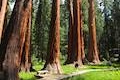
One could easily spend weeks, months, or years exploring Sequoia National Park. If you are only in the park for a day, be sure to hit the highlights. The short hikes to General Sherman Tree (largest in the world) and Moro Rock (panoramic viewpoint on a monolith) should not be missed. If time permits, consider hiking to Tokopah Falls or Tharp’s Log.
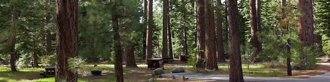
With so much to see at Sequoia National Park, consider staying overnight. Several campgrounds in Sequoia and Kings Canyon National Parks provide good camping options.
Kings Canyon National Park borders the north side of Sequoia National Park and the National Park Service manages the two parks as one massive 1,350 square mile entity. It is possible to visit both national parks in one trip.
Mount Whitney, the highest point in California and the lower 48, rises high over the east side of Sequoia National Park.
Sequoia National Park Hiking
This collection of trails in Sequoia National Park lists hikes from north to south. The table may also be sorted alphabetically or by distance to help you select your next trek. Each trail links to its own report complete with photos, GPS maps, elevation profiles, directions, and all the other information needed to locate and enjoy these trails. Below the table is an interactive map showing the location of each hike.
| Trail | Description | Distance | Location |
|---|---|---|---|
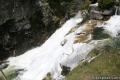
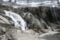 300 300 | Tokopah Falls This gradual out and back hike visits the tallest waterfall in Sequoia National Park. | 4.2 miles 630 feet | 36.6048, -118.7249 |
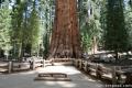 310 310 | General Sherman Tree This paved out at back hike visits the world's biggest tree. | 1 mile 200 feet | 36.5848, -118.74984 |
 320 320 | Congress Loop This easy paved loop visits the fourth and fifth tallest Sequoias in the world (among others). | 2 miles 230 feet | 36.5848, -118.74984 |
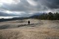 330 330 | Sunset Rock This out and back hike visits a large granite dome with great views to the west. | 2 miles 50 feet | 36.5657, -118.7724 |
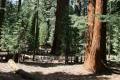
 333 333 | Big Trees Trail This easy, educational, and beautiful loop explores the giant sequoias around Round Meadow. | 1.4 miles 50 feet | 36.564866, -118.773736 |
 340 340 | Beetle Rock This short walk from the Giant Forest Museum to Beetle Rock visits a granite dome with great views and stunning sunsets. | 0.25 miles 50 feet | 36.5647, -118.77425 |
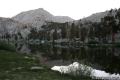
 350 350 | Crescent Meadow This level loop visits a Sequoia you can stand inside (Chimney Tree) and another that someone used to live in (Tharp's Log). | 1.6 miles 150 feet | 36.5548, -118.7490 |
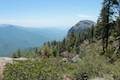 353 353 | Sugar Pine and Bobcat Point Trails Loop This short but diverse loop peaks at Bobcat Point, which presents a fierce perspective of Moro Rock and a massive canyon. | 1.5 miles 250 feet | 36.5548, -118.7490 |
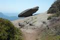 358 358 | Hanging Rock Trail This short out and back hike passes views of Moro Rock en route to a balancing boulder on a canyon rim at the edge of the Giant Forest. | 0.35 miles 100 feet | 36.549128, -118.768186 |
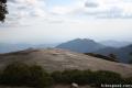
 360 360 | Moro Rock This short out and back hike (with a lot of stairs) sports panoramic views and should be considered a mandatory hike for first time visitors to Sequoia National Park. | 0.6 miles 300 feet | 36.5469, -118.7656 |
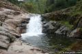
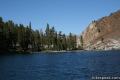
 370 370 | Marble Falls This out and back hike takes a flower-lined path up a mountain canyon to a powerful waterfall. | 8 miles 2,150 feet | 36.51785, -118.80115 |
 380 380 | Paradise Creek This short stroll leaves Buckeye Flat Campground to visit the perfect swimming hole for a hot summer day in the Sierra. | 0.5 to 6 miles 75 feet | 36.52185, -118.76352 |
 390 390 | Panther Creek This out and back hike follows the Middle Fork Trail to a 100 foot waterfall into the Middle Fork of Kaweah River. | 6 miles (or farther) 600 feet | 36.52755, -118.7513 |
 420 420 | Hockett Trail This out and back hike descends through sequoias to East Fork Kaweah River and farther into the backcountry of Mineral King. | 3 to 5 miles (or farther) 600 feet | 36.46424, -118.6690 |
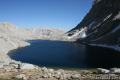
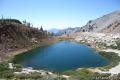 440 440 | Monarch Lakes Trail This out and back hike visits a spectacular pair of lakes high above Mineral King Valley. | 9.4 miles 2,500 feet | 36.45305, -118.59665 |
 430 430 | Eagle Lake Trail The out and back hike climbs the west side of Mineral King Valley to a high-elevation lake. | 7.2 miles 2,200 feet | 36.4488, -118.5954 |
 550 550 | Mount Pickering This 13,485-foot summit rises above Sky Blue Lake to offer sweeping views of the sierra. | 30 miles 3,500 feet | 36.527133, -118.290875 |
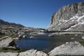 560 560 | Sky Blue Lake This hike extends beyond Lower Soldier Lake up Miter Basin to a deep blue lake surrounded by 14,000-foot peaks. | 26 miles 2,300 feet | 36.532788, -118.273494 |
 570 570 | Primrose Lake This trek visits a lake off the side of Miter Basin near Sky Blue Lake and below Mount Pickering. | 28 miles 2,300 feet | 36.521144, -118.276173 |
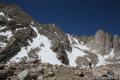
 580 580 | Mount Langley This trek enters Sequoia from the east through Inyo National Forest to reach a 14,042-foot summit with towering views of the Sierra. | 22 miles 4,000 feet | 36.524419, -118.238826 |
 590 590 | Lower Soldier Lake This 19.2-mile loop crosses Cottonwood Pass and New Army Pass to visit a beautiful lake that is an ideal camping spot for backpackers heading higher and deeper into the Sierra. | 17.6 to 20.8 miles 1,500 to 2,300 feet | 36.503604, -118.269331 |
Or explore hikes around Sequoia National Park on the Hike Finder Map