Hikes in Monterey County
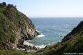
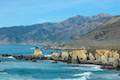
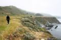
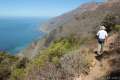
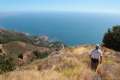
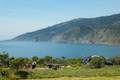
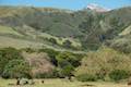
Monterey County is a beautiful coastal area of California. Some of Monterey County’s finest trails are found around Big Sur, a charming town 140 miles south of San Francisco. The Big Sur name also applies to the fifty miles of coastline between Big Sur and San Simeon, which is as beautiful as any in the world. Big Sur is defined by dramatic and beautiful landscapes. Tall green mountains drop to rugged shores and mesmerizing blue waters.
Highlights of Monterey County


Visit Monterey County
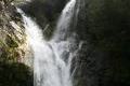
The drive up Highway One is so scenic that many people don’t get out to hike at all, but they should! The region offers numerous great trails. Los Padres National Forest protects much of the wild coast, but several other state parks are also involved, including Julia Pfeiffer Burns State Park, home of one of the most spectacular waterfalls on the planet, McWay Falls. Many of the trails in the Big Sur region are free, so get out of the car and stretch your legs on these fine trails with unforgettable ocean views.
Closure Alert: Winter storms caused major damage and multiple closures along Highway 1 for most of 2017. As of July 2018, the entire highway has reopened, but delays may occur. Check on the status of roads and parks before heading out.
Monterey County Hiking
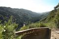
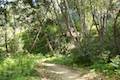
This collection of trails covers Monterey County along the California coast between Big Sur and San Simeon. These hikes are listed from north to south, but the table may also be sorted alphabetically or by distance to help you pick your next hike. Each trail links to its own report complete with directions, photos, GPS maps, elevation profiles, and all the other information needed to locate and enjoy these day hikes. You can also view hikes around Monterey County on the Hike Finder Map.
| Trail | Description | Distance | Location |
|---|---|---|---|
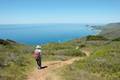 017 017 | Ridge Trail - Panorama Trail - Bluff Trail Loop This loop in Andrew Molera State Park crosses a coastal ridge, bluff, and beach that are packed with amazing Big Sur views. | 8.7 miles 1,100 feet | 36.28741, -121.8441 |
 020 020 | Pfeiffer Falls and Valley View This out and back trek is like two hikes in one, reaching a waterfall in a canyon of redwoods and a vista point overlooking the Big Sur River Valley. | 2.4 miles 550 feet | 36.25066, -121.7858 |
 022 022 | Nature Trail - River Path Loop This easy loop explores woodlands along the Big Sur River and a redwood grove that includes the unique and impressive Proboscis Tree. | 0.55 miles 15 feet | 36.250472, -121.781215 |
 025 025 | Big Sur River Gorge This off-trail hike ventures up the Big Sur River on a water-wading boulder-hopping adventure to a crystal clear pool that’s a gorgeous Big Sur swimming hole. | 0.5 50 feet | 36.2464, -121.7721 |
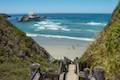
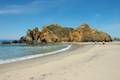 030 030 | Pfeiffer Beach This short walk reaches an absolutely stunning beach that's a classic feature of the Big Sur landscape. | 0.2 miles (or more) 10 feet | 36.2382, -121.81353 |
 050 050 | Partington Cove This out and back hike visits a tunnel-accessed cove and a secluded beach in Julia Pfeiffer Burns State Park along the scenic Big Sur coast. | 1.5 miles 270 feet | 36.1770, -121.6937 |
 053 053 | Canyon Falls This out and back hike heads inland up McWay Creek past a picnic area in a redwood grove to a lovely little waterfall in Julia Pfeiffer Burns State Park. | 0.9 miles 225 feet | 36.16014, -121.668523 |
 055 055 | McWay Falls This out and back hike looks out on a stunning Big Sur waterfall that pours 80 feet right on to the beach in Julia Pfeiffer Burns State Park. | 0.6 miles 50 feet | 36.1587, -121.67054 |
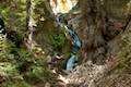
 057 057 | Hare Creek Trail, Limekiln Trail, and Falls Trail This out and back hike in Limekiln State Park explores a trio of trails along lovely streams in redwood-lined canyons, reaching Limekiln Falls and historic lime kilns. | 2.65 miles 250 feet | 36.010436, -121.518588 |
 060 060 | Pacific Valley Bluff Trail This short out and back hike extends from Highway One to an ocean bluff with fantastic views of the Big Sur Coast. | 1.1 miles 50 feet | 35.932648, -121.468927 |
 063 063 | Sand Dollar Beach This short hike to Big Sur's longest beach passes two scenic overlooks on the way to the sand. | 0.5 miles (or more) 125 feet | 35.921639, -121.466913 |
 065 065 | Jade Cove and Plaskett Rock Point This loop across ocean bluff visits a prominent peninsula and a small cove. | 1.5 miles 150 feet | 35.91705, -121.46905 |
 070 070 | Cruickshank Trail This hike into Silver Peak Wilderness starts with bold ocean views and crosses redwood groves to reach Upper Cruickshank Camp at a junction with Buckeye Trail, 2.5 miles from Highway One. | 5 - 9.25 miles 1,150 - 1,925 feet | 35.843073, -121.403025 |
 075 075 | Buckeye Trail This hike reaches incredible ocean vistas and trail camps in the Silver Peak Wilderness. Connect Cruickshank Trail and Buckeye Trail for an excellent shuttle hike of 8.25 miles or more. | 6.5 - 9.25 miles 1,450 - 1,925 feet | 35.821754, -121.374454 |
 080 080 | Salmon Creek Falls This out and back hike visits a fine 120-foot waterfall near the start of Salmon Creek Trail. | 0.25 miles 60 feet | 35.816032, -121.356699 |
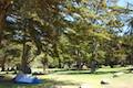
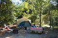
Monterey County Camping
There are many places to camp along the Big Sur coast in Los Padres National Forest and various California State Parks. Here are a few of the developed campgrounds:
 | Plaskett Creek Campground This 45-site campground in Los Padres National Forest is positioned across Highway One from Sand Dollar Beach and Plaskett Rock Point on the coast of Big Sur. |
 | Kirk Creek Campground This outstanding 33-site campground in Los Padres National Forest has enormous ocean views from a bluff along the Big Sur coast. |
 | Limekiln State Park Campground This small Big Sur campground at the bottom of Limekiln Canyon has sites along a creek through a redwood grove and near the ocean, with access to trails up Limekiln Canyon. |
 | Pfieffer Big Sur State Park Campground This large campground in the heart of Big Sur is spread out through oak and redwood groves along the Big Sur River. |
 | Andrew Molera State Park Trail Camp This trail camp is easy to reach (just a short walk in) with campsites in a meadow along the Big Sur River near Molera Beach. |
Or explore hikes around Monterey County on the Hike Finder Map