Hikes in Washington
Washington is a great state for hikers. The Cascade Mountains are the principal range in Washington, running the entire length of the state. This range of volcanic peak includes the famous peaks, Mount Rainier and Mount Saint Helens. Mount Rainier has more glaciers than any mountain in the contiguous United States, making it a stupendously rugged and beautiful environment. The state border-straddling Columbia River Gorge National Scenic Area is also a lovely place to hike.
Highlights of Washington


Washington Hiking
This collection of trails in Washington lists hikes from north to south. The table may also be sorted alphabetically or by distance to help you pick your next hike. Each trail links to its own report complete with photos, GPS maps, elevation profiles, directions, and all the other information needed to locate and enjoy these hikes. Below the table is an interactive map showing the location of each hike.
| Trail | Description | Distance | Location |
|---|---|---|---|
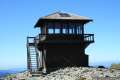 550 550 | Mount Fremont Lookout Trail in Mount Rainier NP This out and back hike visits a fire lookout tower near the summit of Mount Fremont with incredible views over Mount Rainier and the surrounding mountains. | 6 miles 800 feet | 46.914598, -121.642045 |
 600 600 | Naches Peak Loop Trail in Mount Rainier NP This colorful loop crosses fields of summer wildflowers, passes subalpine lakes, and offers great views of Mount Rainier. | 3.75 miles 575 feet | 46.869727, -121.520033 |
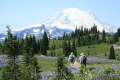
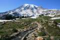 650 650 | Skyline Trail in Mount Rainier NP This tremendously scenic loop on the slopes of Mount Rainier is considered the park's must-do hike. | 5.5 miles 1,625 feet | 46.786691, -121.734536 |
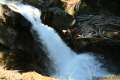 700 700 | Silver Falls Loop Trail in Mount Rainier NP This loop travels through an old-growth forest to a waterfall on Ohanapecosh River in the southeast corner of the park. | 3 miles 300 feet | 46.7362, -121.5664 |
 750 750 | Lava Canyon Trail in Mount Saint Helens NVM This loop explores a colorful canyon re-carved by the 1980 eruption of Mount Saint Helens. | 1.25 miles 250 feet | 46.165878, -122.088824 |
 800 800 | June Lake Trail in Mount Saint Helens NVM This out and back hike visits a small lake and a waterfall on the southern slopes of Mount Saint Helens. | 2.6 miles 450 feet | 46.137203, -122.156568 |
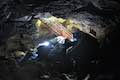
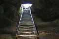 850 850 | Ape Cave in Mount Saint Helens NVM This adventurous underground hike travels through one of the longest lava tubes in the world. | 0.75 - 3.75 miles 400 feet | 46.108362, -122.211432 |
 900 900 | Trail of Two Forests in Mount Saint Helens NVM This short nature trail tours a landscaped that was transformed by a molten lava flow. For extra fun, crawl through a 50-foot long lava tube beneath the trail. | 0.25 miles 25 feet | 46.099126, -122.212565 |
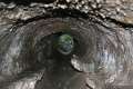
 910 910 | Guler Ice Cave in Gifford Pinchot NF This short hike goes underground to explore an old lava tube with frozen stalactites and stalagmites, plus other interesting cave features. | 0.25 miles 25 feet | 45.9613, -121.63265 |
 920 920 | Coyote Wall This partial loop hike has panoramic views from basalt cliffs rising from the Columbia River. | 5.8 miles 1575 feet | 45.7006, -121.4012 |
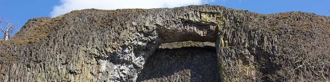
 921 921 | Catherine Creek Arch This hike leads to the base of a curious natural arch in a basalt bluff. | 1 mile 100 feet | 45.7105, -121.3621 |
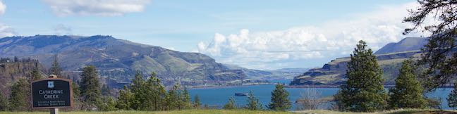
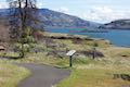 922 922 | Catherine Creek Interpretive Trail This paved loop with plentiful views across the Columbia River Gorge explores meadows that burst with seasonal wildflowers, passing an overlook for a small waterfall. | 0.9 miles 100 feet | 45.71041, -121.36165 |
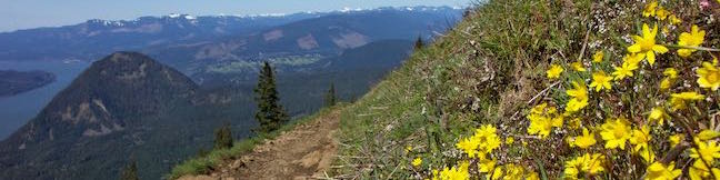
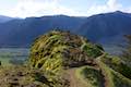
 925 925 | Dog Mountain This hike explores forests, wildflower-covered slopes, and grand views from a mountain along the Columbia River Gorge. | 6.65 - 7.4 miles 2825 feet | 45.6992, -121.7080 |
 928 928 | Hamilton Mountain The beautiful lollipop loop visits bombastic waterfalls and panoramic cliffs along the Columbia River Gorge in Beacon Rock State Park. | 7.75 miles 2025 feet | 45.6326, -122.0198 |
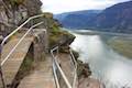 930 930 | Beacon Rock Trail This hike takes an impressively engineered trail packed with switchbacks that scale a monolith along the Columbia River in Beacon Rock State Park. | 1.6 miles 600 feet | 45.62854, -122.02222 |
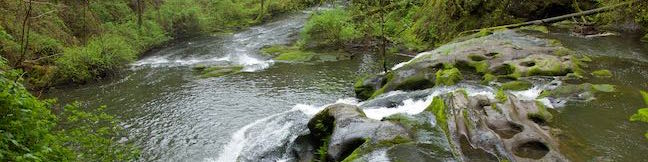
 940 940 | Round Lake Loop & Pothole Falls This circuit wraps around a soothing lake with a side trail to cubbyhole cascades. | 1.6 miles 200 feet | 45.60395, -122.4070 |
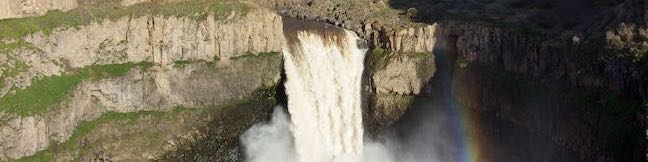
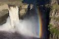 980 980 | Palouse Falls This short walk leads to a clifftop viewpoint facing a bold 180-foot waterfall in a basalt-walled canyon. | 0.15 miles 40 feet | 46.6637, -118.2275 |
Or explore hikes around Washington on the Hike Finder Map