
Do you want to go on a long hike in a dark tunnel? Ape Cave is the place. Ape Cave is one of the longest lava tubes in the world, measuring approximately 2.5 miles from end to end. Hikers may travel unguided through the lava tube. Make just a few preparations and Ape Cave will deliver a one-of-a-kind adventure.
From the cave’s main entrance, visitors have two options:
- Head down to the lower end and back for a 3/4 of a mile round trip hike
- Trek up the cave 1.5 miles to an upper entrance, gaining 400 feet over numerous dark obstacles. Resurface and return to the main entrance by hiking back 1.25 miles above ground. The mile and a half underground takes approximately two hours to complete, but the memory will last a lot longer.
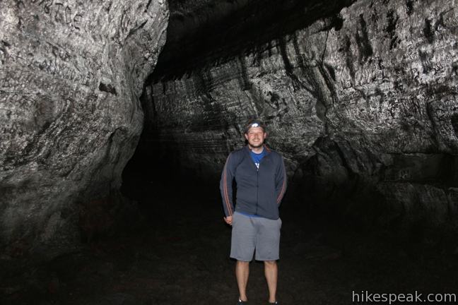
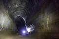
Before setting out, be sure that you have at least three sources of light per person. A bright lantern is a very useful, as the black walls of volcanic rock aggressively absorb the light from flashlights. Several breakdowns are located in the cave, where rocks from the ceiling of the tube have crashed to the floor creating piles of jagged boulders that you must traverse. As a result, sturdy footwear is a must.
The temperature in the cave hovers in the lower 40s. You will encounter strong breezes in narrow stretches of the tube that can chill things even further, so dress accordingly.
A white moisture covers some walls of the cave, which visitors have unfortunately written on with their fingers. Do not touch the “cave slime” as it takes years for this fungus to regrow. Other commonsense rules include: no food or beverages, no smoking, no fires, no rock collecting, no littering, and no pets.
How was this incredible cave formed?
Approximately 2,000 years ago, Mount Saint Helens had an eruption of red flowing lava, an incredibly rare type of eruption for volcanoes in the Cascade Mountains. (Mount Saint Helens explosive eruption in 1980 is a good example of how volcanoes in this range typically erupt.) This flow of basalt (liquid lava) burned down the south slope of Mount Saint Helens into a stream bed. The surface cooled and hardened, insulating the lava underneath, which continued to flow, eroding away rocks and soil. After months of lava flow, the volcano went dormant. The remaining basalt flowed until it hardened, leaving an empty tube behind.
The cave went undiscovered until 1947, when a logger nearly lost a tractor in the sinkhole that is now the cave’s main entrance. A local club nicknamed the Helens Apes first explored the cave, giving the tube its name.
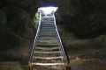
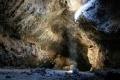
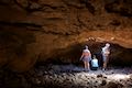
Descend the metal staircase into Ape Cave and enter a world of darkness. The lower stretch of the cave takes about an hour to explore. In this area you will see a formation called “the meatball,” where a round block of lava fell from the ceiling into flowing lava and was carried to an narrower section where it became wedged.
Traveling up the lava tube provides a longer and more difficult hike. Some of the hiking is easy, unobstructed walking over a smooth floor. However, two dozen breakdowns complicate the path, requiring you to climb over piles of ceiling fragments. Additionally there are choke stones to crawl under and dry falls to climb up, including one vertical dry falls that is 8-feet tall. It is pitch black in the cave, making it easy to lose track of time and distance. The good thing is, you can’t get lost. The cave has not junctions, so just head up the tube.
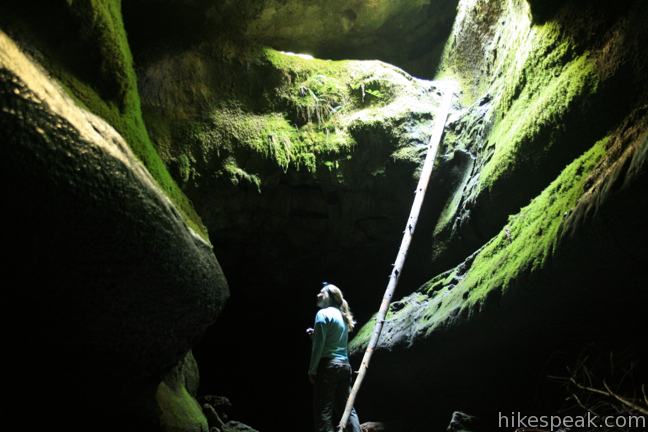
The ceiling of Ape Cave is high, approximately 50 feet in areas. The “big room” of the tube is 88-feet wide, while narrower passages are just a few feet wide.
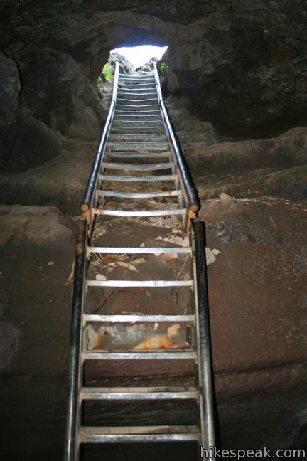
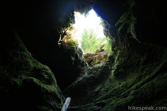
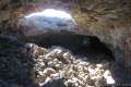
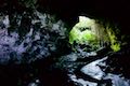
After what feels like hours walking in the dark, you will start to imagine that there is light ahead in the tube. As you get closer, you discover that it wasn’t your imagination. Light really is coming in from a skylight overhead. Alas, the first skylight you reach is not the cave exit. Luckily, a second skylight is not far beyond with a metal ladder that will bring you back to the surface.
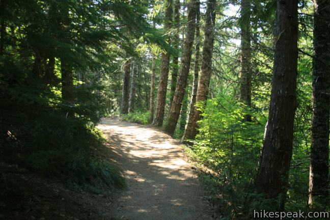
Let the sun’s rays warm you up as you hike 1.25 miles on an easy downhill grade back to the main entrance of the cave and on to the parking lot.
Ape Cave Lava Tube is located in Mount Saint Helens National Volcanic Monument in Gifford Pinchot National Forest. A Northwest Forest Pass is required to park at the trailhead. You may self-register for the $5 day pass at the trailhead. An annual America the Beautiful national parks pass can also be used in lieu of the regional national forest pass.
To crawl through a smaller lava tube and learn more about volcanoes, visit nearby Trail of Two Forests. For another long hike through a lava tube, check out Lava River Cave near Bend, Oregon.
Directions to the Trailhead
- From Interstate 5, 140 miles south of Seattle and 25 miles north of Portland, take exit 21 on to Route 503 East toward Cougar.
- After 35 miles, turn left on Forest Service Road 83.
- Drive two miles north to Forest Service Road 8303.
- Turn left again.
- Drive 0.9 miles to the trailhead parking area, which is on the right after the Trail of Two Forests.
Trailhead Location
Trailhead address: National Forest Road 8303, Gifford Pinchot National Forest, Cougar, WA 98616
Trailhead coordinates: 46.108362, -122.211432 (46° 06′ 30.10″N 122° 12′ 41.15″W)
View Mount Saint Helens in a larger map
Or view a regional map of surrounding Washington trails and campgrounds.


 | Trail of Two Forests in Mount Saint Helens National Volcanic Monument This short nature trail tours a landscaped that was transformed by a molten lava flow. For extra fun, crawl through a 50-foot long lava tube beneath the trail. |
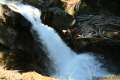
 | June Lake in Mount Saint Helens National Volcanic Monument This 2.6-mile hike visits a small lake and a waterfall on the southern slopes of Mount Saint Helens. |
 | Lava Canyon Trail in Mount Saint Helens National Volcanic Monument This 1.25-mile loop explores a colorful canyon re-carved by the 1980 eruption of Mount Saint Helens. |
 | Guler Ice Cave in Gifford Pinchot National Forest This short hike goes underground to explore an old lava tube with frozen stalactites and stalagmites, plus other interesting cave features. |
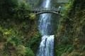 | Multnomah Falls in Columbia River Gorge This 0.4 to 2.6-mile hike visits Oregon's tallest (and probably most visited) waterfall, offering something to hikers of all abilities. |
 | More trails in Washington Explore other hikes in the Evergreen State, including Mount Rainier National Park. |
 | Lava River Cave in Newberry National Volcanic Monument (Oregon) This underground hike explores a lava tube south of Bend that is filled with fascinating volcanic features. |
| Guler Ice Cave in Gifford Pinchot National Forest (Washington) This short hike goes underground to explore an old lava tube with frozen stalactites and stalagmites, plus other interesting cave features. |
| Trail of Two Forests in Mount Saint Helens National Volcanic Monument (Washington) This short nature trail tours a landscaped that was transformed by a molten lava flow. For extra fun, crawl through a 50-foot long lava tube beneath the trail. |
 | Ape Cave in Mount Saint Helens National Volcanic Monument (Washington) This adventurous underground hike travels through one of the longest lava tubes in the world. |
 | Caves Trail in Crates of the Moon National Monument (Idaho) This 1.6 mile travels above and below the surface, exploring lava tubes in the Great Rift Lava Flow. |
 | Lava Tube in Mojave National Preserve (California) This short 0.6-mile hike drops below the desert surface into an old lava tube with a spectacular skylight. |
 | Kalahuipua'a Trail and Fishponds Loop (Hawaii) This action-packed 1.7-mile hike explores a lava field with a lava tube shelter and impressive fishponds along a gorgeous coastline. |
 | Kaumana Caves (Hawaii) This underground hike explores lava tubes on the edge of Hilo, created by an 1881 eruption of Mauna Loa. |
 | Camping around Mount Saint Helens Beaver Bay Campground and Paradise Creek Campground are two of the places to camp a convenient distance from this trail. |
Common Questions about Ape Cave Lava Tube in Mount Saint Helens National Volcanic Monument
- Is the trail open?
- Yes. You should expect to find that Ape Cave Trail is open. There are no recent reports of trail closures. If you discover that the trail is closed, please help your fellow hikers by reporting a closure.
- Do I need a permit for this hike?
- Yes. National Forest Northwest Forest Pass.
- How much time does this hike take?
- It takes approximately 1 hour 45 minutes to hike Ape Cave Trail. Individual hiking times vary. Add extra time for breaks and taking in the views.
- How long is this hike?
- The hike to Ape Cave Trail is a 3.75 mile loop with 400 feet of elevation change.
- Are dogs allowed on this trail?
- No, dogs are likely not allowed on Ape Cave Trail. The trail is primarily open to hikers.
- Are there caves on this hike?
- Yes, Ape Cave Trail features caves to explore.
- Does this hike visit a lava tube?
- Yes, pack a headlamp to check out the lava tube on your trek to Ape Cave Trail.
- What mountain range is this trail in?
- Ape Cave Trail is located in the Cascade Range.
- Where is the trailhead located?
- The trailhead for Ape Cave Trail is located in Cougar, Washington.
Trailhead Address:
National Forest Road 8303
Cougar, Washington 98616
Trailhead Coordinates:
46.108362, -122.211432 - What are the driving directions to the start of the hike?
To get to the trailhead: From Interstate 5, 140 miles south of Seattle and 25 miles north of Portland, take exit 21 on to Route 503 East toward Cougar. After 35 miles, turn left on Forest Service Road 83. Drive two miles north to Forest Service Road 8303. Turn left again. Drive 0.9 miles to the trailhead parking area, which is on the right after the Trail of Two Forests.
View custom Google Maps directions from your current location.
- Are there other trails near Ape Cave Trail?
- Yes, you can find other nearby hikes using the Hikespeak Hike Finder Map.

19 Comments on Ape Cave Lava Tube in Mount Saint Helens National Volcanic Monument
What hikers are saying:
✨ Generated summary of user commentsThis trail provides a unique subterranean adventure where the various obstacles remain manageable for most visitors in good physical condition. Families with children find the lower end of the cave more approachable for a first visit. Please be aware that dogs are strictly prohibited inside the cave environment.
“The obstacles within the cave area definitely doable for most visitors in reasonable shape.” Jump to comment ↓
what are the hours and days that the ape caves are open?
The national forest does not list any restrictions, so like the other trails in this area, you should be able to show up any time of day and any day of the week that you like.
I went here before with some people, but I don’t remember how to get there. I remember we had to take different routes and park at a different entrance because it was snowed in. Do you know if there is a lot of snow there now? Also do you have any details on the parking pass needed? Online shows sno pass and forest pass? My friends got a ticket last time.
What is the closest camp ground to the trail head for the ape caves? Also my kids are 11, 9 and 3. Is this a good place to take them? They are very active and good kids they can do many tuff hikes most kids their age cant do.
Beaver Bay Campground is a good close place to camp. With children, I’d recommend starting with the lower end of Ape Cave. If they’re not happy down there it will be easier to turn around than in the longer and tougher upper part of the tube.
I want to plan for the ape cave hike on 4th July. I have few questions:
1) What is the nearest place for car parking?
2) Please recommend we should start from lower end or upper end of the cave. We are 2 adults.
3) Drinking water is allowed inside the cave?
4) Any fees or charges?
Thanks
Isha
1 – There is a large parking area on National Forest Road 8303. See the directions above.
2 – It will be easier to start at the lower end
3 – Yes
4 – You will need to purchase and display a National Forest Northwest Forest Pass or a National Parks pass to park at the trailhead
COULD I GET ADDRESS OF APE CAVES FOR GPS THANK YOU
The address and coordinates are included in this write-up with the directions just above the map. Have a good trip.
Are dogs welcome in the Ape Caves or the surrounding trails.
Dogs aren’t allowed inside the cave, but dogs are allowed on nearby hikes, like the Trail of Two Forests
Is “dispersed camping” allowed in the area?
I am planning to visit and hike in the area of Ape Cave on the 4th of July 2015 and have some questions:
1. Is the area open on the 4th? I heard of restrictions in some areas but wasn’t sure for Ape Cave area.
2. Can I purchase a day pass for parking there at Ape Cave or must I purchase in town?
You can buy a pass online or several other places. According to the Forest Service, Ape Cave is open, with a snow caution posted two weeks ago.
are ape caves open now? any snow in sight? are the roads really safe? does each person have to pay $5.00 for the day pass at trailhead?
The fee is per vehicle
how easy is it to climb the eight foot wall in the cave ?
The obstacles within the cave area definitely doable for most visitors in reasonable shape.
Is the Apes Lava Tube open in October 2020? If so, any Covid requirements?