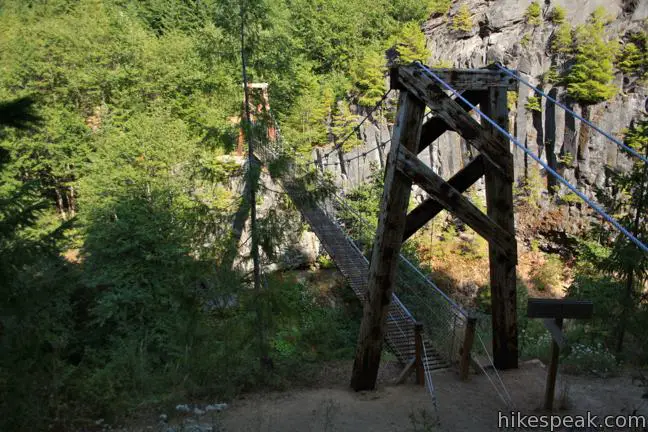
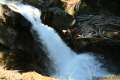
With a name like Lava Canyon, you aren’t likely to overlook this trail in the blast zone of Mount Saint Helens. What can you expect from this hike? For starters, you’ll travel down a narrow canyon with precarious edges and exiting waterfall views. Then you’ll cross the canyon on a suspension bridge that bounces and sways a bit too much for comfort. If that sounds good, get ready for an adventure on this 1.25-mile loop with 250 feet of elevation loss.
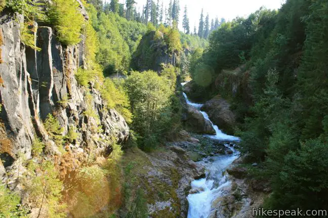
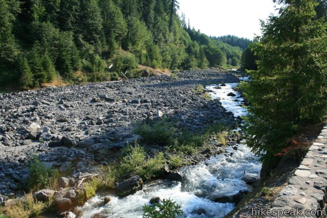
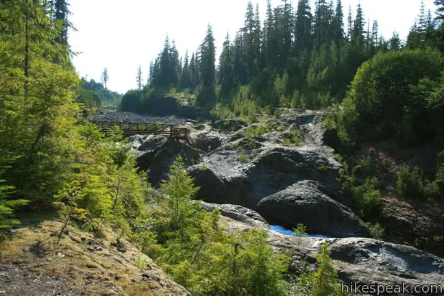
Begin down a series of long gradual paved switchbacks that take you through a pine forest to the rim of the canyon. When you reach canyon, the diameter of the trees suddenly shrinks. This is the first sign that you are entering an area that received a makeover from the 1980 eruption of Mount Saint Helens. When the famous volcano ruptured, snow on its southern face melted rapidly, creating a rush of mud and debris. The powerful mixture coursed down the canyon, tearing through everything in its path. When the river returned to its usual flow, it had a colorful canyon of exposed bedrock to pass through, which it decorated a ribbon of pools and cascades.
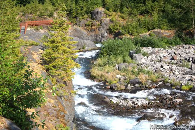
You will get your first good perspective of lava canyon after 0.15 miles at a wooden overlook. From here, the pavement ends and the real hiking begins. Less than a quarter mile past the overlook, the trail splits. To the right there is a sturdy bridge crossing the river, which you will use at the end of the loop. For now, stick to the left, proceeding down the west side of the canyon.
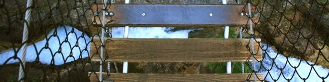
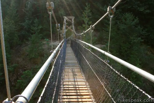
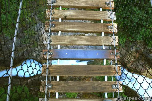
Along the way, there are several signs warning about the danger of falling. Stay on the trail and away from treacherous edges as you traverse the canyon rim over the next quarter mile to a daunting suspension bridge. As you step from plank to plank on the suspension bridge, it will wobble and wiggle. This is not a good bridge for anyone afraid of heights, but the views up the canyon from the center of the bridge are worth the agony.
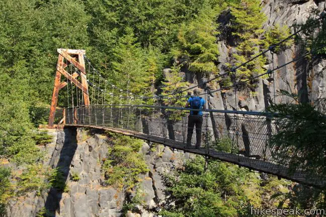
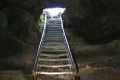
Once you make it across the bridge, take a deep breath and loop up the east side of the ravine. You will use a ladder and stairs to get through rock left here by older lava flows.
After a quarter mile, reach the sturdier bridge at the top of the gorge and complete the loop. From there, hike back the canyon the way you came. If you would like to extend this hike, Lava Canyon Trail continues below the suspension bridge for a couple miles to a lower traihead, but becomes more difficult to travel.

Lava Canyon Trail is located in Mount Saint Helens National Volcanic Monument in Gifford Pinchot National Forest. A Northwest Forest Pass is required to park at the trailhead. You may self-register for the $5 day pass at the trailhead. An annual America the Beautiful national parks pass can also be used in lieu of the regional national forest pass.
Directions to the Trailhead
- From Interstate 5, 140 miles south of Seattle and 25 miles north of Portland, take exit 21 on to Route 503 East toward Cougar.
- After 35 miles, turn left on Forest Service Road 83 and drive ten miles to the trailhead on the right at the end of the road.
Trailhead Location
Trailhead address: National Forest Road 83, Gifford Pinchot National Forest, Cougar, WA 98616
Trailhead coordinates: 46.165878, -122.088824 (46° 09′ 57.16″N 122° 05′ 19.76″W)
View Mount Saint Helens in a larger map
Or view a regional map of surrounding Washington trails and campgrounds.


 | June Lake in Mount Saint Helens National Volcanic Monument This 2.6-mile hike visits a small lake and a waterfall on the southern slopes of Mount Saint Helens. |
 | Ape Cave in Mount Saint Helens National Volcanic Monument This adventurous underground hike travels through one of the longest lava tubes in the world. |
 | Trail of Two Forests in Mount Saint Helens National Volcanic Monument This short nature trail tours a landscaped that was transformed by a molten lava flow. For extra fun, crawl through a 50-foot long lava tube beneath the trail. |
 | Guler Ice Cave in Gifford Pinchot National Forest This short hike goes underground to explore an old lava tube with frozen stalactites and stalagmites, plus other interesting cave features. |
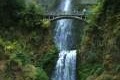 | Multnomah Falls in Columbia River Gorge This 0.4 to 2.6-mile hike visits Oregon's tallest (and probably most visited) waterfall, offering something to hikers of all abilities. |
 | More trails in Washington Explore other hikes in the Evergreen State, including Mount Rainier National Park. |
 | Camping around Mount Saint Helens Beaver Bay Campground and Paradise Creek Campground are two of the places to camp a convenient distance from this trail. |
Common Questions about Lava Canyon in Mount Saint Helens National Volcanic Monument
- Is the trail open?
- Yes. You should expect to find that Lava Canyon Trail is open. There are no recent reports of trail closures. If you discover that the trail is closed, please help your fellow hikers by reporting a closure.
- Do I need a permit for this hike?
- Yes. National Forest Northwest Forest Pass.
- How much time does this hike take?
- It takes approximately 45 minutes to hike Lava Canyon Trail. Individual hiking times vary. Add extra time for breaks and taking in the views.
- How long is this hike?
- The hike to Lava Canyon Trail is a 1.25 mile loop with 250 feet of elevation change.
- Are dogs allowed on this trail?
- Yes, dogs are allowed on Lava Canyon Trail. The trail is open to hikers, dogs.
- Is Lava Canyon Trail good for kids?
- Yes, this hike is likely suitable for children. It is relatively short (1.25 miles) with manageable elevation gain.
- What mountain range is this trail in?
- Lava Canyon Trail is located in the Cascade Range.
- Where is the trailhead located?
- The trailhead for Lava Canyon Trail is located in Cougar, Washington.
Trailhead Address:
National Forest Road 83
Cougar, Washington 98616
Trailhead Coordinates:
46.165878, -122.088824 - What are the driving directions to the start of the hike?
To get to the trailhead: From Interstate 5, 140 miles south of Seattle and 25 miles north of Portland, take exit 21 on to Route 503 East toward Cougar. After 35 miles, turn left on Forest Service Road 83 and drive ten miles to the trailhead on the right at the end of the road.
View custom Google Maps directions from your current location.
- Are there other trails near Lava Canyon Trail?
- Yes, you can find other nearby hikes using the Hikespeak Hike Finder Map.

8 Comments on Lava Canyon in Mount Saint Helens National Volcanic Monument
What hikers are saying:
✨ Generated summary of user commentsHikers experience a mix of excitement and caution while navigating the narrow gorge and its rapid river. The terrain features slick surfaces that are unforgiving to those who wander off trail or approach the water too closely. Brenda advises against bringing small children because the ground is too slippery, particularly in the rugged sections below the suspension bridge.
Heading up that way to do some camping in about a week and we have a six year old. I was wondering if this trail would be appropriate for a family with a small child? It sounds like fun!
That bridge might be a little scary, but you should be able to check it out as long as you keep a close eye on the kids. The nearby Trail of Two Forests will be better for children though.
Do not take young kids below the suspension bridge !!! Extreme hiking trail …
Camp ground name and number for this area. Or for the app caves
Beaver Bay Campground is a good nearby option.
There is a fundraiser for a Memorial sign to raise awareness of the individuals who have lost their lives on this trail, so that hikers may take better care should they choose to explore off trail. My wife and I just hiked here a few months ago and ran into a search party of people from Longview WA looking for the body of a young man who fell into the river a few days prior, and he was not recovered. Just something to keep in mind. Smooth slick surfaces and a rapid moving river in a narrow gorge with deep pools and multiple falls, maybe exciting to see up close, but is unforgiving as evidenced by a recorded body count that I’ve read is up over a dozen in the last ten years or so. Something people should know about, before they go, in my opinion. Please pass it on. Thank you, and Happy Hiking!
That young man was my grandson. we were there looking for him. I wouldn’t take small children there too easy to slip and fall
Is suspension bridge still closed? Is there a way around it? Thanks!