Red Rock Canyon National Conservation Area

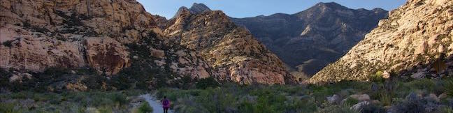
With steep mountains of gray limestone above striking sandstone cliffs, Red Rock Canyon is full of dramatic landscapes. Red Rock Canyon National Conservation Area preserves over 300 square miles in the Mojave Desert west of Las Vegas. Despite this grand size, Red Rock Canyon is easy to explore. Reaching the park is a breeze (it is less than twenty miles from the Las Vegas Strip) and much can be seen from a 13-mile long Scenic Drive. Several trails depart from the Scenic Drive allowing visitors to explore rugged canyon and unique rock formation.

Highlights of Red Rock Canyon

  • Hike up a multi-colored sandstone canyon to a basin of water accompanied by views of Las Vegas.
  • Ride or drive this picturesque road to hit up highlights throughout Red Rock Canyon.
  • Hike through spectacular sandstone formations in the Calico Hills near the start of Scenic Drive.
  • See pictographs and a seasonal waterfall on this circuit bordering Red Rock Wash.

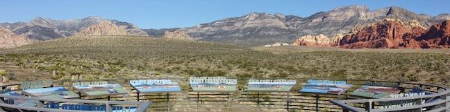
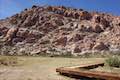
The Bureau of Land Management manages Red Rock Canyon NCA. While you might expect a BLM park to be minimally developed, this is not the case. Red Rock Canyon has a large visitor center, numerous well-established trails and information panels. To stay overnight in the park, check out the 72-site Red Rock Canyon Campground. Red Rock Canyon receives over two million visitors each year.

There is an entrance fee at the start of the Scenic Drive of $15 per vehicle ($10 for motorcycles or $5 for bicycles and pedestrians (prices as of 2019). National Parks (America the Beautiful) passes can also be used for entry.

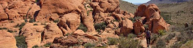
Most visits are built around the Scenic Drive in Red Rock Canyon, which lives up to its name. This is a gorgeous circuit by car and a particularly picturesque pursuit on a bike. The Scenic Drive is a one-way road, so start with hikes at the beginning of the loop, visiting unbelievable sandstone formations in the Calico Hills. Bikes use the right lane of this two-lane road, so drive slowly and in the left lane.

Dogs are allowed on all trails in the park on leashes.

Hikes in Red Rock Canyon National Conservation Area

The trails below are listed in the order that they are reached when traveling on Scenic Drive, a one way road through the park. The final hike on this list, Red Spring Boardwalk, is not located on Scenic Drive.

Calico Hills Trail
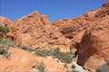
Calico I and Calico II
This hike of 0.8 to 2.75 miles or more explores dramatically shaped and colored sandstone formations in the Calico Hills near the start of Scenic Drive.
Calico Tanks TrailCalico Tanks Trail
This 2.5-mile hike ventures up a colorful canyon to a pond in a sandstone-framed basin alongside a great view of Las Vegas.
Lost Creek CanyonLost Creek Canyon
This short hike visits Lost Creek Waterfall, a seasonal waterfall in a steep canyon above Red Rock Wash.
Willow Springs LoopWillow Springs Loop
This 1 to 1 1/3-mile circuit travels along Red Rock Wash, exploring desert landscapes, Native American rock art, and potentially a seasonal waterfall.
Red Spring BoardwalkRed Spring Boardwalk
This easy 0.55-mile nature trail circles a meadow at the base of the Calico Hills and visits a small but relied upon spring.


hikespeak
Chimney Beach Trail Lake Tahoe Nevada Chimney Beach Hike Humboldt-Toiyabe National Forest
Before your visit to Lake Tahoe goes up in smoke, take a hike to Chimney Beach - where a standing-on-its-own fireplace and chimney serve as an unsual landmark for a lovely little cove. The brick chimney is all that's left of an old cabin built in the sand between boulder-strewn points on the east shore of Lake Tahoe. If curiosity about the chimney draws you to Chimney Beach, the beautiful... Read more.
OK! Add to trails I’ve hiked
OK! Add to trails I want to hike
Tagged with · Beaches · Carson City · Free Trails · Ruins · South Lake Tahoe
Distance: 1.1 miles · Elevation change: 215 feet
By: Published: Last updated: July 26, 2023
Cave Rock Trail Lake Tahoe Nevada Overlook Hike
Gaze out from Route 50 as it travels along the southeast side of Lake Tahoe and you'll find nice views of the lakeshore and its surrounding mountains. Seven miles up from the state border in South Lake Tahoe, Nevada Route 50 slips through a tunnel in a tall pointed ridge of volcanic rock. The road itself is scenic, but the sight of Cave Rock should have you speculating how superb things must... Read more.
OK! Add to trails I’ve hiked
OK! Add to trails I want to hike
Tagged with · Free Trails · Glenbrook · South Lake Tahoe · Summits
Distance: 0.9 miles · Elevation change: 165 feet
By: Published: Last updated: July 26, 2023
Scenic Drive Red Rock Canyon National Conservation Area Las Vegas Nevada Scenic Loop Road Red Rock Canyon
Scenic Drive is a picturesque loop road through Red Rock Canyon National Conservation Area. The road offers a memorable drive or bike ride with access to numerous trails and overlooks. Scenic Drive is 12.5 miles long if you drive straight through and about 13 miles long if you pull off at each of the various overlooks. A few things to know from the start: Scenic Drive is a one-way road.... Read more.
By: Published: Last updated: August 21, 2019
Calico Hills Red Rock Canyon National Conservation Area Las Vegas Nevada Calico I and Calico II Hike Calico One to Calico Two
The whimsically concocted concentration of vibrant red-orange Aztec sandstone known as the Calico Hills is a must-see destination in Red Rock Canyon National Conservation Area. After leaving the visitor center, the Scenic Drive heads straight to the Calico Hills, passing three overlooks and trailheads, Calico I, Calico II, and Sandstone Quarry (the start of Calico Tanks Trail). You could... Read more.
OK! Add to trails I’ve hiked
OK! Add to trails I want to hike
Tagged with · Bureau of Land Management · Las Vegas
Distance: 2.1 miles · Elevation change: 200 feet
By: Published: Last updated: June 12, 2021
Willow Springs Loop Pictographs Red Rock Canyon National Conservation Area Las Vegas Nevada Lost Creek Canyon Willow Springs Picnic Area Hike
Willow Springs Loop explores an area off the northwest side of the Scenic Drive through Red Rock Canyon National Conservation Area. While it is bordered by steep mountains, the loop actually crosses easy terrain along Red Rock Wash. Visit pictographs left behind by Native American's near Willow Springs Picnic Area and meander through desert landscapes. A spur to Lost Creek Waterfall, a... Read more.
OK! Add to trails I’ve hiked
OK! Add to trails I want to hike
Tagged with · Bureau of Land Management · Desert Canyons · Las Vegas · Pictographs · Waterfalls
Distance: 1.33 miles · Elevation change: 165 feet
By: Published: Last updated: September 9, 2019