Tasmania
No, it’s not its own country (Tasmania is part of Australia) but it is its own world. The isolated island of Tasmania is 250 kilometers across the Bass Strait from the state of Victoria in Mainland Australia. The wild island consists of 68,000 square kilometers (26,000 square miles) of mountain peaks, rainforests, waterfalls, and white sand beaches. Only half a million people live on Tasmania, making it a secluded destination for hiking, camping, and touring. The capital city of Hobart (where about 40% of the population reside) has the island’s main airport and is a great place to start exploring Tasmania. You won’t even need to leave Hobart to check out the scenic summit of Mount Wellington.
Highlights of Tasmania


Hikes in Tasmania, Australia
This collection of hiking tracks in Tasmania lists the hikes roughly from north to south. The table may also be sorted alphabetically or by distance to help you pick your next trek in Tasmania. A search feature can be used to quickly isolate the track you are looking for. Each hike links to its own report complete with photos, GPS maps, elevation profiles, directions, and all the other information needed to locate and enjoy these tracks. Below the table is information on some other activities, camping, and lodging, followed by an interactive map of Tasmania.
| Trail | Description | Distance | Location |
|---|---|---|---|
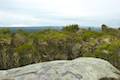 895 895 | Mount William This out and back hike tops a short summit that is the high point of Mount William National Park with panoramic views over the coastline at the northeast corner of Tasmania. | 3.6 km 140 meters | -40.90896, 148.207197 |
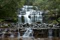
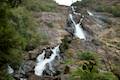 905 905 | Saint Columba Falls This out and back hike descends into a rainforest to the base of a powerful 90-meter tall waterfall. | 1.2 km 40 meters | -41.321271, 147.926203 |
 915 915 | Cataract Gorge This loop combines Zig-Zag Track, Cataract Walk, and Bridge Walk to explore Cataract Gorge Reserve, an impressive natural area just outside the center of Launceston. | 3.4 km 80 meters | -41.445923, 147.122482 |
 925 925 | Liffey Falls This out and back walk in the rainforest passes the Upper Cascades on the Liffey River to reach the base of lovely Liffey Falls, one of Tasmania's finest waterfalls. | 2.2 km 70 meters | -41.700153, 146.759189 |
 945 945 | Apsley Waterhole & Lookout Track This loop travels through a eucalyptus forest to a popular swimming hole on the Apsley River in Douglas-Apsley National Park. | 1.2 km 30 meters | -41.865414, 148.190469 |
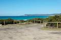
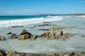 950 950 | Friendly Beaches This hike explores a long, pristine beach on the east coast of Tasmania north of the Freycinet Peninsula. | 0.1 km 10 meters | -41.992685, 148.285445 |
 953 953 | Cape Tourville This short circuit provides big views along the east coast of Freycinet Peninsula, circling 100-meter tall bluffs to reach the Cape Tourville Lighthouse. | 0.6 km 10 meters | -42.122311, 148.34135 |
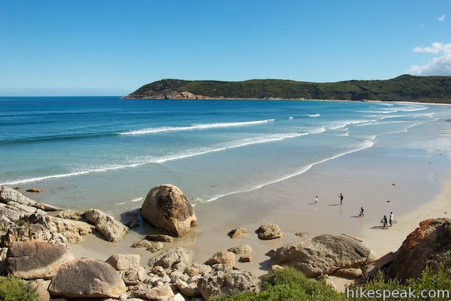
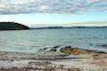
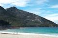 960 960 | Wineglass Bay and Hazards Beach Circuit This rewarding loop through Freycinet National Park visits pristine light sand beaches at Hazards Beach and the renowned Wineglass Bay. | 12 km 220 meters | -42.14581, 148.289189 |
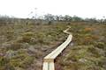 965 965 | Moorland Mosaic This out-and-back boardwalk in Mount Field National Park crosses an alpine meadow covered with an interesting mix of plants. | 0.65 km 20 meters | -42.682995, 146.611678 |
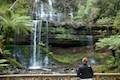 970 970 | Russell Falls & Horseshoe Falls This hike in Mount Field National Park visits one of Tasmania's most famous and beautiful waterfalls and can be extended from 1.8 to 2.65 kilometers by venturing to the top of Russell Falls and nearby Horseshoe Falls. | 1.65 km 80 meters | -42.682073, 146.716127 |
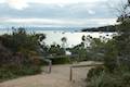
 978 978 | Pinnacles Boardwalk & Summit Trig The short walk on the top of Mount Wellington explores two short boardwalks and a trig station at the summit. | 0.75 km 20 meters | -42.89542, 147.237723 |
 980 980 | Octopus Tree and Circle Track This loop in Hobart's Wellington Park reaches a unique eucalyptus tree with tentacles for roots that wrap around a boulder. | 1.1 km 50 meters | -42.908751, 147.24798 |
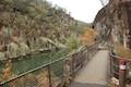
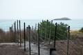
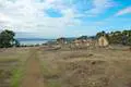 985 985 | Coal Mines Historic Site This short loop explores the ruins of an old prison and coal mine that relied on convict laborers. | 0.8 km 10 meters | -42.988141, 147.714598 |
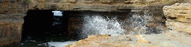
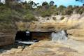 990 990 | Blowhole & Fossil Bay Lookout This short walk in Tasman National Park reaches a coastal vista point and a wave-carved tunnel through a rocky point that has the potential to spray up like a whale spout. | 0.45 km 10 meters | -43.034392, 147.947942 |
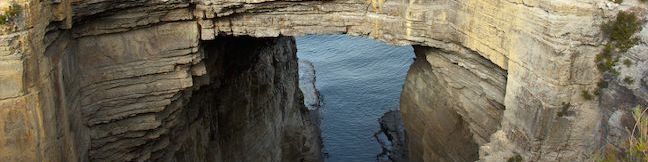
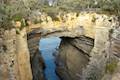 991 991 | Tasmans Arch & Devils Kitchen This short walk visits two impressive features on the coast of the Tasman Peninsula, a natural bridge and a chasm carved by the sea. | 0.9 km 9 meters | -43.042071, 147.950548 |
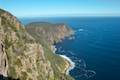 996 996 | Cape Raoul This bushwalk explores the pristine coastline at the southwest end of the Tasman Peninsula, reaching a cape with daunting 200-meter tall cliffs dropping to swirling seas. | 12 - 14 km 240 meters | -43.195255, 147.777145 |
Scenic Roads in Tasmania, Australia
 | Forester Kangaroo Drive This 11.25-kilometer scenic dirt road in Mount William National Park offers great wildlife viewing of the area’s Forest kangaroos or Bennetts wallabies. |
Camping and Lodging in Tasmania, Australia
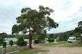 | Big4 Iluka on Freycinet Holiday Park This holiday park in the coastal town of Coles Bay at the top of Freycinet Peninsula offers tent sites, campervan sites, and cabins, as well as quick access to nearby Freycinet National Park. |
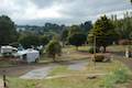 | Big4 Launceston Holiday Park This holiday park in Launceston offers tent sites, campervan sites, and cabins on a hillside near the city center. |
 | Friendly Beaches Campground This primitive campground offers oceanfront camping surrounded by beautiful beaches in Freycinet National Park. |
 | Lime Bay State Reserve Campground This shaded campground is bordered by sandy beaches in a cove on a remote thumb of the Tasman Peninsula. |
 | Mayfield Beach Conservation Area Campground This beachfront campground is located on Great Oyster Bay on the east coast of Tasmania. |
 | Richardsons Beach Campground This scenic bay side campground offers powered and non-powered campsites in Freycinet National Park. |
 | Stumpys Bay Campground This campground is split into four areas along Stumps Bay with numerous campsite for visitors to Mount William National Park. |
Transportation in Tasmania, Australia
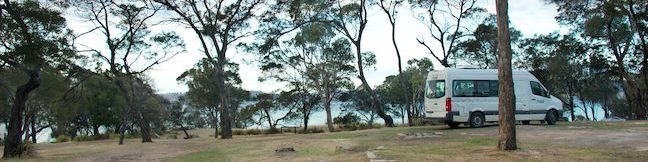
 | Venturer Campervan Find out more about the Venturer, an accommodating two-person campervan that can be rented from Britz. |
Or explore hikes in Australia on the Oceania Hike Finder Map