The Tasman Peninsula extends into the Tasman Sea in the southeast corner of Tasmania. While the peninsula was once used as a penitentiary, a visit to the peninsula’s impressive coastline today will feel like anything but prison. Just south of the narrow isthmus at Eaglehawk Neck, the east coast of the peninsula has several easy-to-reach wonders, including Tasmans Arch and Devils Kitchen (as well as nearby Fossil Bay Lookout and the Blowhole).
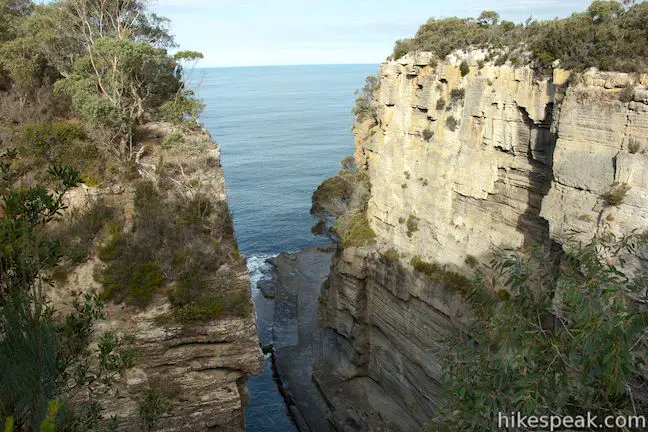
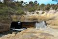
Tasmans Arch is a tall natural bridge in the sea cliffs and Devils Kitchen is a deep trench without an arch that has also been carved out by the Tasman Sea. Both attractions can be observed from overlooks at a pair of car parks and you can gain more perspectives, including a coastal overlook, but walking a 0.9-kilometer (0.55 mile) loop.
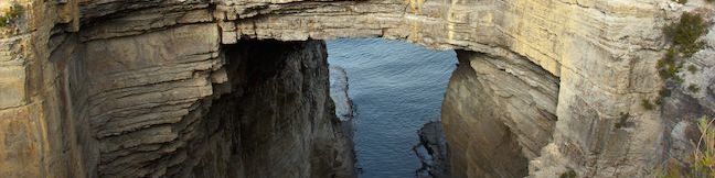
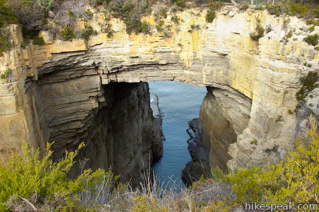
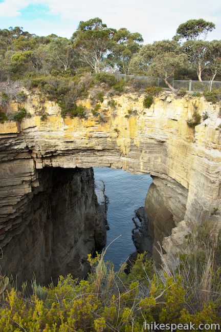
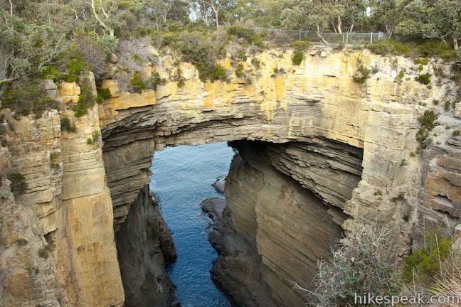
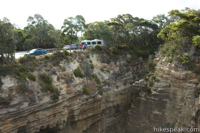
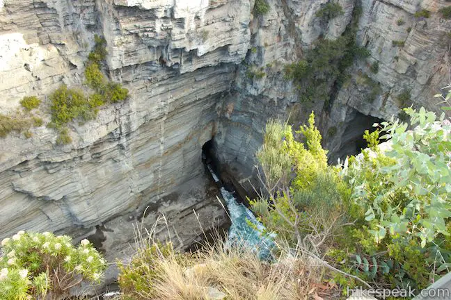
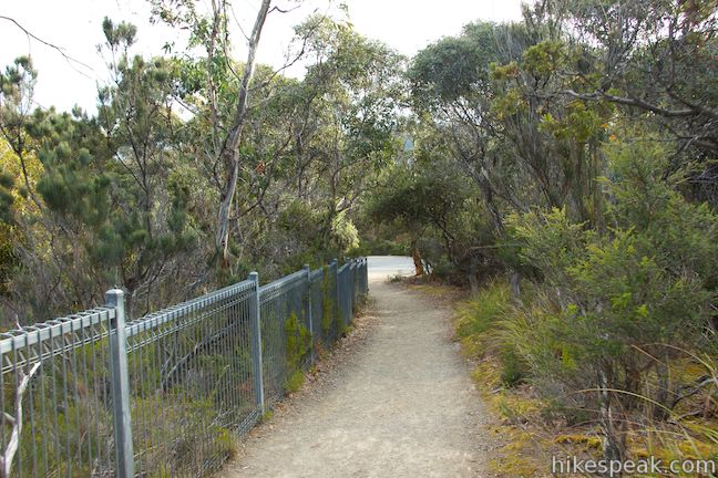
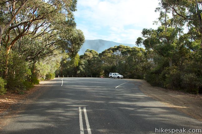
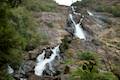
At first glance, the car park at Tasmans Arch Lookout appears to be an unimpressive dirt lot in the forest. Get out of your vehicle and step up to the railing and you’ll be blown away by what you see. Right next to the car park there is a deep hole with steep cliff walls dropping to the ocean. The forest on the far side of the hole is actually a suspended land bridge, Tasmans Arch. Below the arch, waves pass in and out between the Tasman Sea.
How did such an impressive formation come to be? A panel at the lookout explains that:
Tasmans Arch is what’s left of the roof of a large sea cave, or tunnel, that was created by wave action over many thousands of years. The pressure of water and compressed air, sand, and stones acted on vertical cracks (joints) in the cliff, dislodging slabs and boulders.
The panel also points out how this landscape is still changing:
When you look into Tasman Arch it seems to be old. While it may be old, it is still changing. Is the arch growing, or is the roof thinning, or are the walls expanding? Below this viewing point and visible from the arch (opposite) is the entrance to a new cave, initiated by wave action. In the cliff-face opposite, you will see many weak zones similar to those that gave way to create an arch when the cave roof collapsed. This immensely slow process of erosion is continuing. This arch will eventually collapse and another ‘Devils Kitchen’ will be formed.
The siltstone cliffs in this area eroded unevenly to create these unique formations. This process started about 6,000 years ago as sea levels rose following the last ice age. Waves cut notches into the cliffs, suspending slabs of rock that eventually fell to create caves and shore platforms. Waves would erode away a joint in the rocks until it became a sea cave. The sea cave would grow deeper and become a tunnel, and continue grow deeper and wider until the roof collapsed, as the panel explains:
Thousands of years of erosion deepened or lengthened the tunnel. Eventually the tunnel reached a fracture that runs parallel to the coastline (the joint is visible to the right and left below this viewing point). This fracture is linked at sea level to the Devils Kitchen. The roof collapsed at this joint, leaving a pit behind an arch.
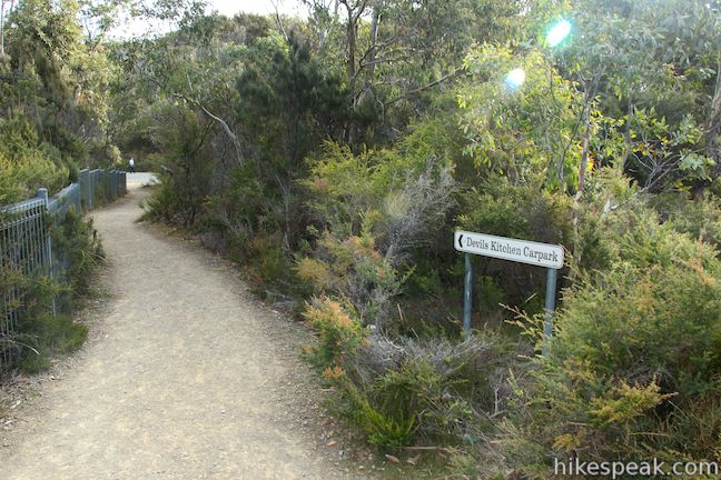
The next highlight in the area is Devils Kitchen, which you can reach by driving a bit farther down the road or by taking a short walk that adds extra views.
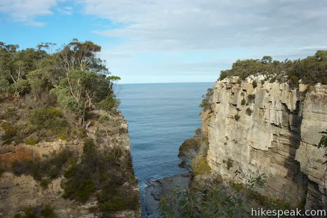
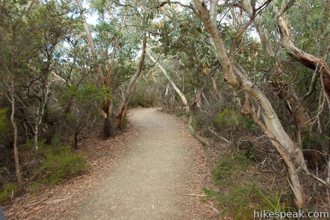
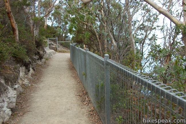
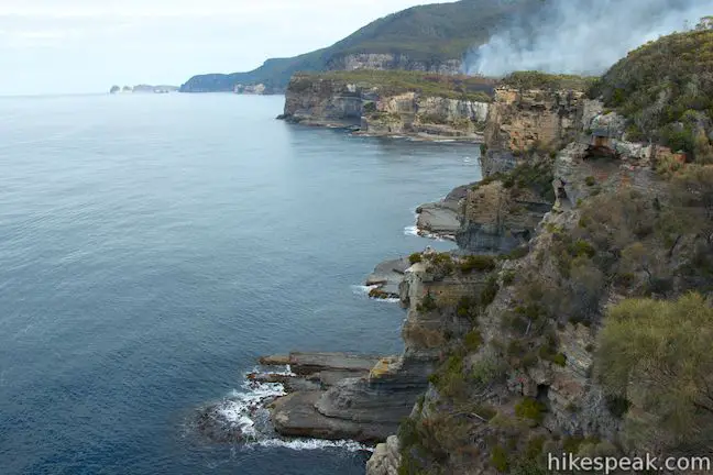
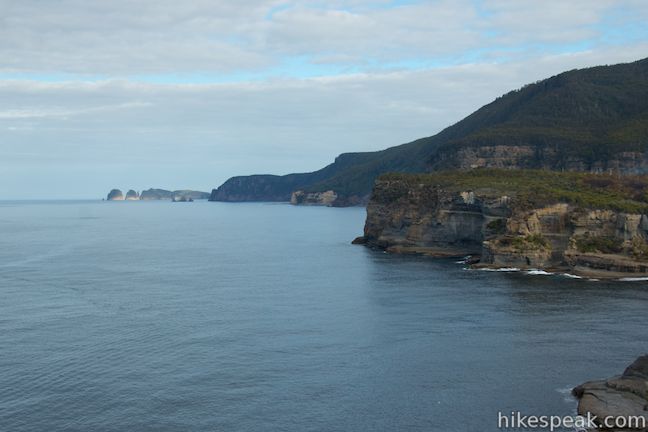
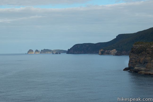
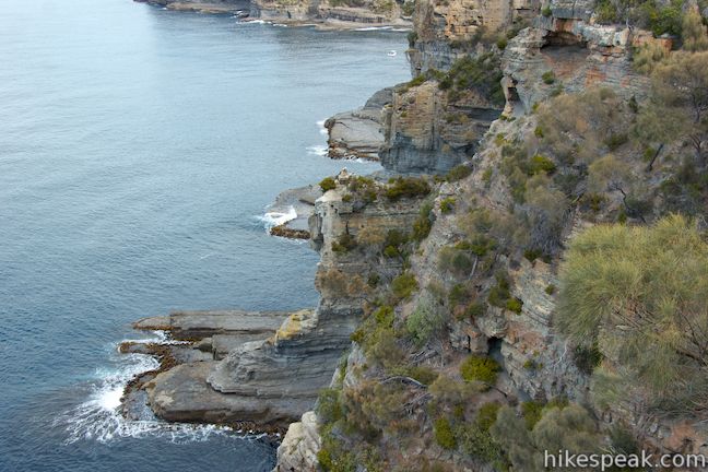
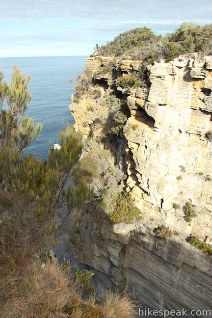
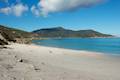
Leave Tasmans Arch Lookout and head clockwise around the opening on a wide walking path. Quickly come to a junction with a spur on the left that extends out to an coastal overlook with views south down the sawtooth coastline. The entrances to Tasmans Arch and Devils Kitchen are visible from here, and you can see a long way down the beautiful coast of the Tasman Peninsula.

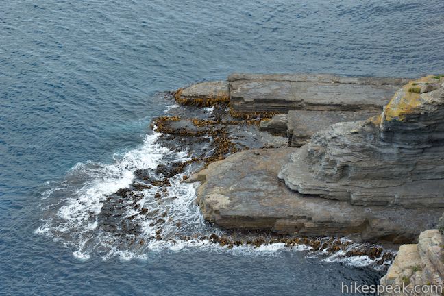
Have a seat on the stone bench and watch waves wash over wave-cut platforms at sea level and smash into rock cliffs. These waves ever-so-slowly erode away the rock face. These waves exploit vertical joints in the rock to create caves that could eventually grow into natural bridges under the right circumstances.
Devils Kitchen and Tasmans Arch, as well as another nearby natural bridge called the Blowhole, all began as small caves chipped away by waves. Maybe in a few thousand years there will be a new arch on this coastline.
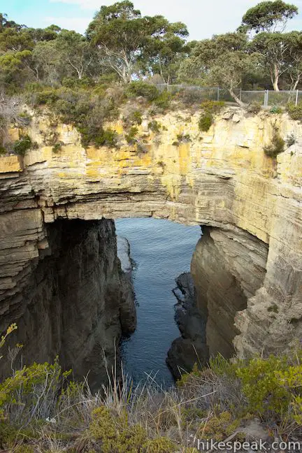
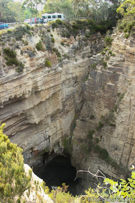
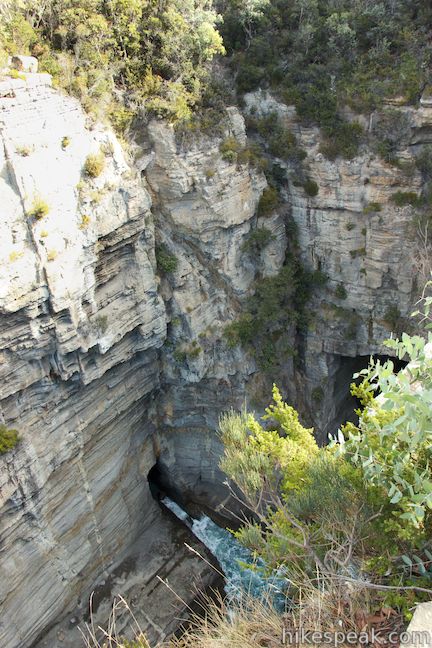
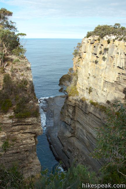
Return to the main track and continue to the left, crossing over the top of Tasmans Arch. When you come to another junction, turn left to walk out to a fenced-off overlook on a ledge on the side of Devils Kitchen. Devils Kitchen is what Tasmans Arch would look like without the arch, a long trench framed by steep rock walls. Waves roll in from the sea and slosh around between the cliffs.
Return to the main track and continue to the left, where the track will come to an end at Tasmans Arch Road. Turn left and walk a short distance to the car park at the road end where there is another lookout over Devils Kitchen. From this vantage, at the back of the chasm, you have a better perspective of the waves rolling in between the cliffs. There is a panel here that explains how Devils Kitchen came to be:
This geological feature probably started as a sea cave, then a tunnel, and developed into its modern form after the collapse of the cave roof. It is one of several such coastal landforms in the Tasman National Park that have developed in the Permian-age siltstone.
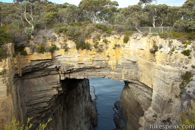
After transitioning from cliff to sea cave to tunnel to chasm, has Devils Kitchen reached its final shape? No. The panel points out an area where the ocean continues to erode the rock walls:
At the end of the gulch, there is an entrance to a new cave and the formation of another on the opposite wall. You can observe where the sea has eroded a joint to form the smaller cave. Rock will collapse from the cave roof, the cave will be enlarged and the sea, acting on a bigger opening, will be able to erode an even greater area.
After you’ve looked in on the Devils Kitchen, you can return along the walking track or just walk 150 meters back up the road to get back to the car park at Tasmans Arch. On your drive to and from Tasmans, you will pass through the town of Doo, where there are several signs containing puns about the area’s name. Doo read them all. If you’re interested in another short walk to a nearby natural bridge, consider it your dooty to also check out the Blowhole and Fossil Bay Lookout. A National Parks Pass is required to visit Tasman National Park. A single day pass will cost $40 or you may purchase an 8-week pass good for all of Tasmania’s National Parks for $80 (all prices in Australian Dollars as of 2021). Dogs and bikes are prohibited on this short walk.
Directions to the Trailhead
- Take Tasman Highway (A3), 25 kilometers east of Hobart to the town of Sorell.
- You will come to an intersection in the center of town where A3 makes a 90-degree turn.
- Take the road leaving A3 at this intersection, which is Coles Street/Arthur Highway (A9).
- This will be a right turn if you are coming from Hobart.
- Drive 51 kilometers on A9 to Blowhole Road, which is just past the isthmus at Eaglehawk Neck.
- Turn right onto Blowhole Road (C338), drive 3 kilometers and turn right on Tasmans Arch Road, following a sign for Tasmans Arch and Devils Kitchen.
- It is 800 meters up this road to the car park at Tasmans Arch and 1 kilometer to the car park at the road end by Devils Kitchen.
Trailhead Location
Trailhead address: Tasmans Arch Road, Eaglehawk Neck, TAS 7179, Australia
Trailhead coordinates: -43.042071, 147.950548 (43° 02′ 31.45″S 147° 57′ 01.97″E)
You may also view a regional map of surrounding Australian trails, campgrounds, and lodging.


 | Blowhole & Fossil Bay Lookout This short walk in Tasman National Park reaches a coastal vista point and a wave-carved tunnel through a rocky point that has the potential to spray up like a whale spout. |
 | Coal Mines Historic Site This 0.8-kilometer loop through the Convict Precinct explores the ruins of an old prison and coal mine that relied on convict laborers. |
 | Cape Raoul This 12 to 14-kilometer hike explores the pristine coastline at the southwest end of the Tasman Peninsula, reaching a cape with daunting 200-meter tall cliffs dropping to swirling seas. |
 | Wineglass Bay and Hazards Beach Circuit This approximately 12-kilometer loop takes a rewarding route through Freycinet National Park, visiting pristine light sand beaches at Hazards Beach and the renowned Wineglass Bay. |
 | Cape Tourville This 0.6-kilometer circuit provides big views along the east coast of Freycinet Peninsula, circling 100-meter tall bluffs to reach the Cape Tourville Lighthouse. |
 | Friendly Beaches This hike explores a long, pristine beach on the east coast of Tasmania north of the Freycinet Peninsula. |
 | Apsley Waterhole & Lookout Track This 1.4-kilometer loop travels through a eucalyptus forest to a popular swimming hole on the Apsley River in Douglas-Apsley National Park. |
 | Cataract Gorge This 3.4-kilometer loop combines Zig-Zag Track, Cataract Walk, and Bridge Walk to explore Cataract Gorge Reserve, an impressive natural area just outside the center of Launceston. |
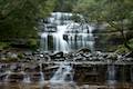 | Liffey Falls This 2.2-kilometer walk passes the Upper Cascades on the Liffey River to reach the base of lovely Liffey Falls, one of Tasmania's finest waterfalls. |
 | Mount William This 3.6-kilometer out and back hike tops a short summit that is the high point of Mount William National Park with panoramic views over the coastline at the northeast corner of Tasmania. |
 | Octopus Tree and Circle Track This 1.1-kilometer loop in Hobart's Wellington Park reaches a unique eucalyptus tree with tentacles for roots that wrap around a boulder. |
 | Pinnacles Boardwalk & Summit Trig The 0.3-kilometer round trip walk on Pinnacles Boardwalk can easily be extended to a 0.75-kilometer walk on the top of Mount Wellington, checking out another short boardwalk and the trig station at the summit. |
 | Russell Falls & Horseshoe Falls This hike in Mount Field National Park visits one of Tasmania's most famous and beautiful waterfalls and can be extended from 1.8 to 2.65 kilometers by venturing to the top of Russell Falls and nearby Horseshoe Falls. |
 | Saint Columba Falls This 1.2-kilometer round trip hike descends into a rainforest to the base of a powerful 90-meter tall waterfall. |
 | More trails in Australia Explore other destinations in Victoria and Tasmania, Australia. |
 | Lime Bay State Reserve Campground This shaded campground is bordered by sandy beaches in a cove on a remote thumb of the Tasman Peninsula. |
 | Mayfield Beach Conservation Area Campground This beachfront campground is located on Great Oyster Bay on the east coast of Tasmania. |
Common Questions about Tasmans Arch and Devils Kitchen in Tasman National Park
- Is the trail open?
- Yes. You should expect to find that Tasmans Arch & Devils Kitchen Track is open. There are no recent reports of trail closures. If you discover that the trail is closed, please help your fellow hikers by reporting a closure.
- Do I need a permit for this hike?
- Yes. National Park Entrance Fee.
- How much time does this hike take?
- It takes approximately 15 minutes to hike Tasmans Arch & Devils Kitchen Track. Individual hiking times vary. Add extra time for breaks and taking in the views.
- How long is this hike?
- The hike to Tasmans Arch & Devils Kitchen Track is a 0.9 km / 0.55 mile loop with 5 meters / 15 feet of elevation change.
- Are dogs allowed on this trail?
- No, dogs are likely not allowed on Tasmans Arch & Devils Kitchen Track. The trail is primarily open to hikers.
- Is Tasmans Arch & Devils Kitchen Track good for kids?
- Yes, this hike is likely suitable for children. It is relatively short (0.55 miles) with manageable elevation gain.
- Are there ocean views on this hike?
- Yes, Tasmans Arch & Devils Kitchen Track offers views of the ocean.
- Where is the trailhead located?
- The trailhead for Tasmans Arch & Devils Kitchen Track is located in Eaglehawk Neck, Tasmania.
Trailhead Address:
Tasmans Arch Road
Eaglehawk Neck, Tasmania 7179
Trailhead Coordinates:
-43.042071, 147.950548 - What are the driving directions to the start of the hike?
To get to the trailhead: Take Tasman Highway (A3), 25 kilometers east of Hobart to the town of Sorell. You will come to an intersection in the center of town where A3 makes a 90-degree turn. Take the road leaving A3 at this intersection, which is Coles Street/Arthur Highway (A9). This will be a right turn if you are coming from Hobart. Drive 51 kilometers on A9 to Blowhole Road, which is just past the isthmus at Eaglehawk Neck. Turn right onto Blowhole Road (C338), drive 3 kilometers and turn right on Tasmans Arch Road, following a sign for Tasmans Arch and Devils Kitchen. It is 800 meters up this road to the car park at Tasmans Arch and 1 kilometer to the car park at the road end by Devils Kitchen.
View custom Google Maps directions from your current location.
- Are there other trails near Tasmans Arch & Devils Kitchen Track?
- Yes, you can find other nearby hikes using the Hikespeak Hike Finder Map.

4 Comments on Tasmans Arch and Devils Kitchen in Tasman National Park
What hikers are saying:
✨ Generated summary of user commentsThe site is valued for its natural beauty and ease of access for all ages. The tessellated rocks and Tasmans Arch are a major photo opp.
How deep is it from top of the Tasman Arch to the water?
[…] The Tasman Arch began as a small sea cave. Constant sea waves formed the Tasman Arch by erosion […]
Hello
We will be in Tasmania in November only for a few days. We would love to see the tessellated rocks and Tasmans Arch and Devils Kitchen. Due to time constraints and age, we cannot do a hike. I have 3 questions:
Do you need a pass just to see these sights mainly for photo opportunities? Do we still need to purchase a park pass for this? If no passes are required is it an easy walk to view these sights?
I appreciate your assistance with these questions.
[…] Continuing on your Tasmanian road trip itinerary, be sure to stop by for an hour or two at Eaglehawk Neck. Perfect for toilet and tea breaks, Eaglehawk Neck is also the home to the famous tessellated rocks along the north end, with the neck of the town itself in the middle, and a treasure chest of goodies in the south. After exploring the natural tessellated seaside rocks, head to the south suburb of Doo Town where each of the houses are named featuring the word “doo” in it. Alternatively, there is a blowhole and the Tasman Arch and Devil Kitchen. […]