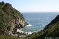
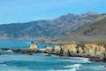
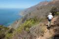
Most of Big Sur’s beautify is obvious – tall green mountains, a ragged coastline, and lots of ocean blue, but some attractive features are practically hidden, and Pfeiffer Beach is one such gem. Pfeiffer Beach has great sand and iconic rock formations, but you won’t see this beach from Highway One (or its begging-to-be-photographed wave-tunneled rocks).
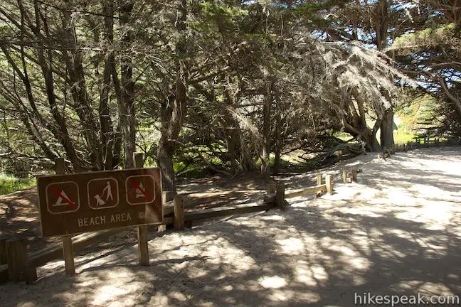
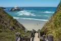
Once you make it to the parking area for this tucked-away treasure, the sand is easily reached via a tenth of a mile long path. Pfeiffer Beach is sheltered by rock formations that look undeniably Big Sur as they get clobbered by waves. It only takes a short walk for Pfeiffer Beach to make a big impression.
This striking beach couldn’t be much closer to the heart of Big Sur, but the road down to Pfieffer Beach from Highway One isn’t well marked, so you could easily drive right past it. Maybe this helps keep the crowds away, because it is just a couple miles drive down Sycamore Canyon Road the day use parking for Pfeiffer Beach.
Pfeiffer Beach in Big Sur
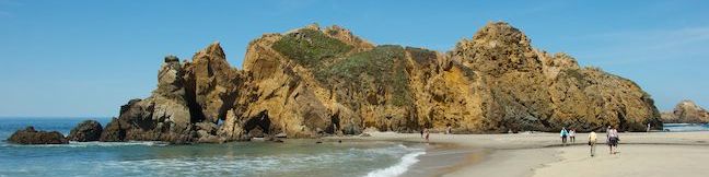
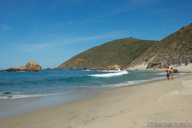
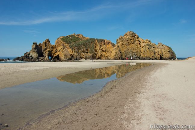
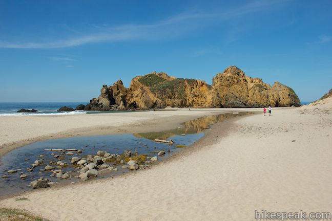
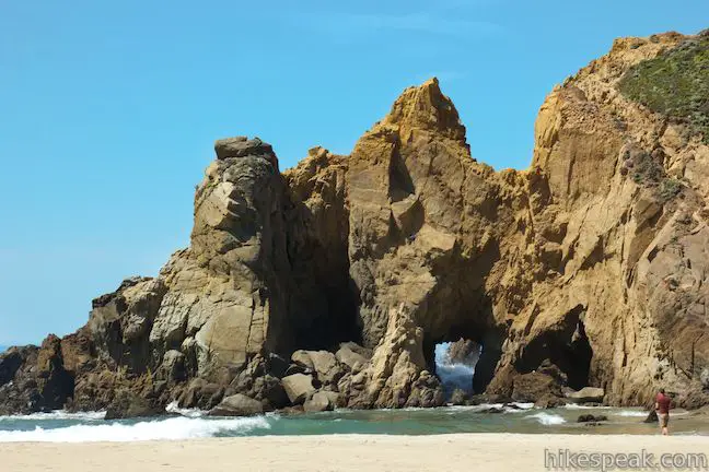
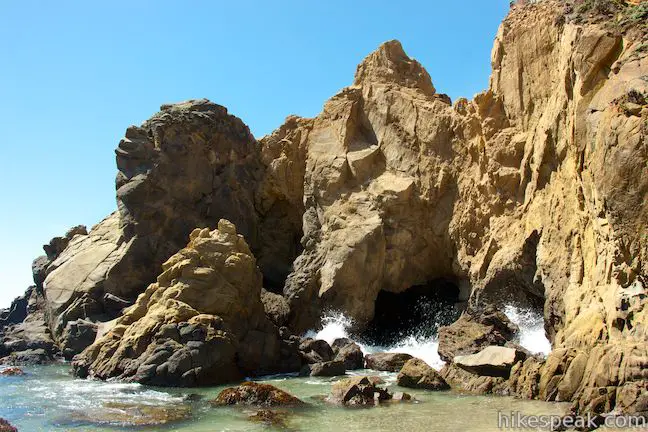
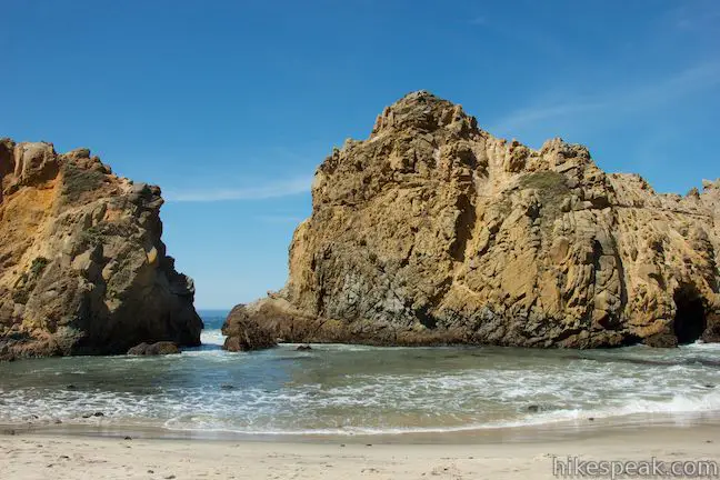
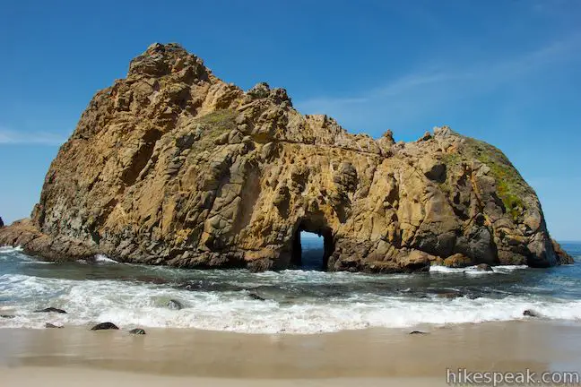
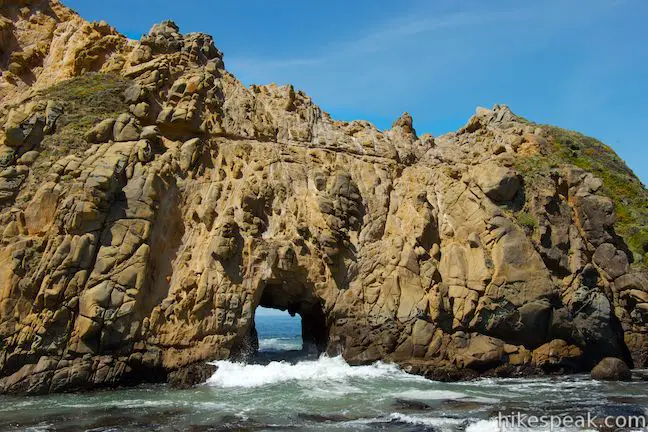
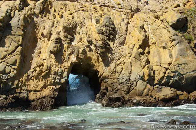
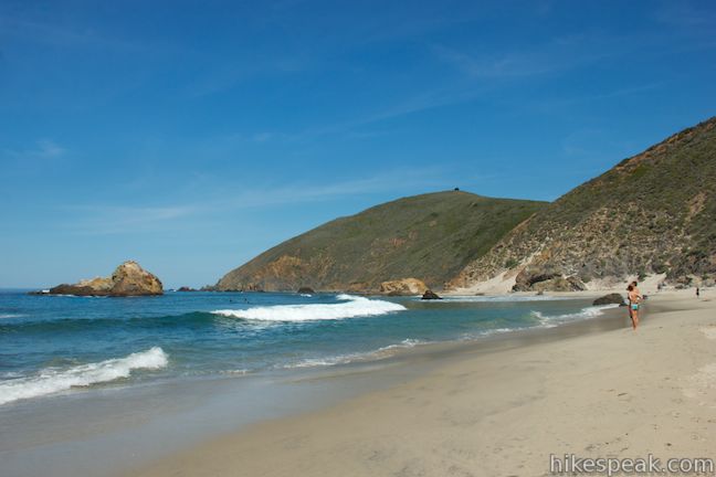
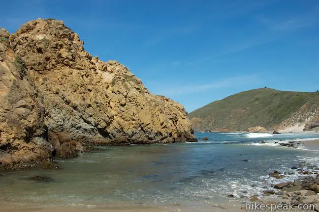
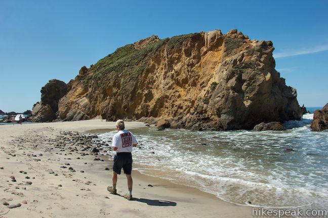
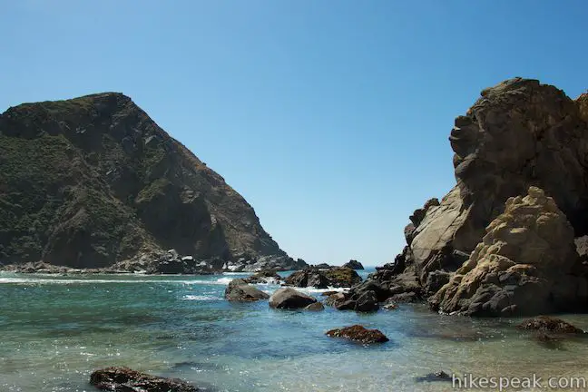
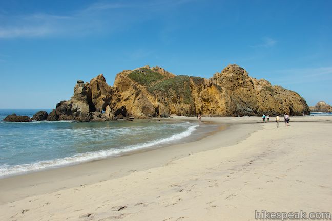
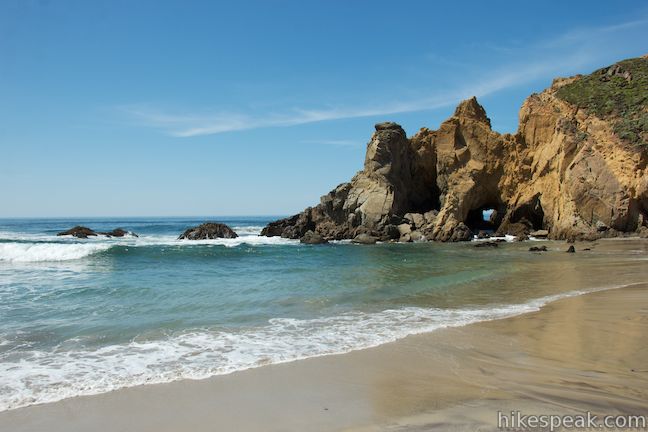
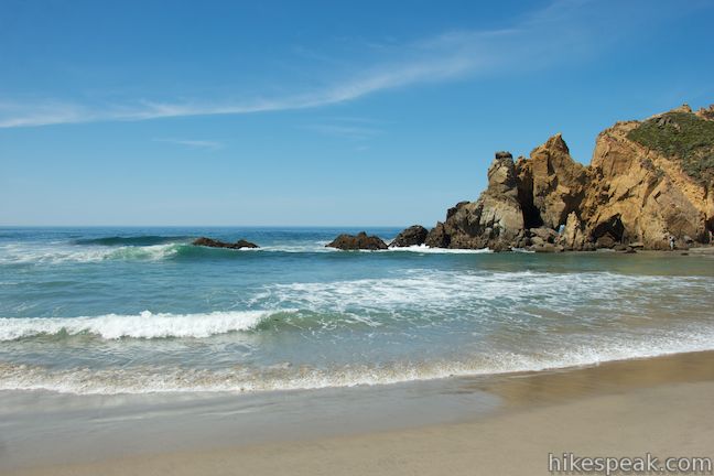
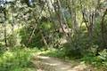
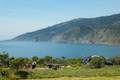
Leave the Pfeiffer Beach Day Use Area parking lot and make your way down a wide sandy trail to the beach. Walk through a riparian woodland with Monterey cypress, and quickly arrive at Pfieffer Beach. Water from the creek to your left forms a long pool in the sand in front of you, which you can easily walk around (or through). To your left, a crescent-shaped arc of sand is backed by tall sea cliffs. Straight ahead, the sand connects to a sea stack of orange rock. A narrow channel separates this rock from a similar, but maybe more dramatic rock formation to the right, just offshore. Tunnels cut through both rocks. Waves flow through the tunnels, popping up in bursts of white foam.
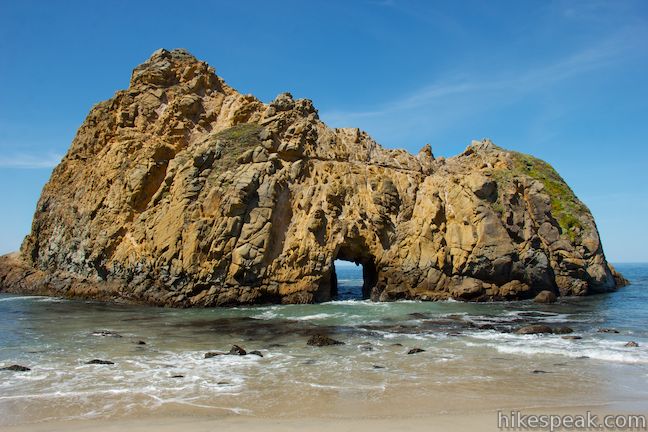
The tunnel going through the middle of the rock on the right is really something to appreciate. This hole in the sea stack looks big enough to drive a truck through. Do an image search for Pfeiffer Beach and you’ll see lots of lovely photos of golden light passing through this opening at sunset.
To the right, around the bend from these rocks, the beach continues north for another tenth of a mile or so.
You may notice some purple-looking sand on the beach, especially after it has rained. Apparently the color comes from almandine garnets dissolving in the cliffs above the beach.
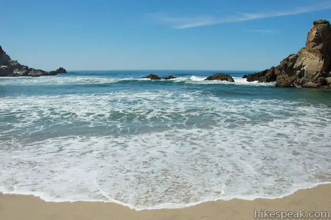
While the waves in the Pacific Ocean look lovely, swimming at Pfeiffer Beach is not recommended due to dangerous rip currents. Instead, watch waves smash into the awesome rock formations or find a pleasant place to relax in the sand. Pfeiffer Beach is a true Big Sur beauty!
The trail between the day use parking area and Pfeiffer Beach is a tenth of a mile long from start to finish. At that length, Pfeiffer Beach Trail is one of the shortest hikes on hikespeak.com, but its exceptional natural beauty make it a must-include. From the end of the trail, you will no doubt walk around the beach a bit, making this a walk of half a mile or more.
To see another beautiful Big Sur beach, check out Sand Dollar Beach.
Pfeiffer Beach Information
Dogs are welcome on Pfeiffer Beach.
Los Padres National Forest oversees the Pfeiffer Beach Day Use Area and a $10 fee per vehicle is charged to park at the beach. Facilities are provided in partnership with the California Coastal Conservancy. The beach and parking area are closed at night.
In place of entrance fees, National Forest Adventure Passes and America the Beautiful National Parks and Federal Recreational Lands Passes are also accepted. Additionally, if you are camping at a nearby campground in Los Padres National Forest (Kirk Creek Campground or Plaskett Creek Campground), you can use the Pfeiffer Beach Day Use Area without paying the entry fee. You do not need to pay the additional $10 entrance fee if you have already paid for a camping permit (price as of 2018). Aside from the use fee, no permit is required to walk to Pfieffer Beach, so get out and enjoy!
Directions to the Trailhead
Pfieffer Beach:
- You'll need to use your odometer to find the road to Pfieffer Beach.
- Sycamore Canyon Road breaks off the west side of Highway One, 1.1 miles south of the entrance to Pfieffer Big Sur State Park and 9.8 miles north of Julia Pfeiffer Burns State Park (1.8 miles north of Nepenthe Restaurant).
- The GPS coordinates of the intersection are 36.240215, -121.777226 (36° 14' 24.77"N 121° 46' 38.01"W).
- Turn down Sycamore Canyon Road, which is only marked with a yellow sign that reads, Narrow Road, No RVs - Trailers.
- Drive 2 1/4 miles down this paved winding road to the day use parking area at road's end.
- You will pass a reassuring plaque near the top of the road that reads, Pfieffer Beach - Two Miles.
- After the entry fee station, an overflow parking area is on your left.
- Continue straight to a second parking area (if you can find a place to park) where bathrooms and a few picnic tables are located near the start of the trail.
Trailhead Location
Trailhead address: Pfieffer Beach, 9101 Sycamore Canyon Road, Los Padres National Forest, Big Sur, CA 93920
Trailhead coordinates: 36.2382, -121.81353 (36° 14′ 17.5″N 121° 48′ 48.7″W)
You may also view a regional map of surrounding Central Coast trails and campgrounds.


 | Big Sur River Gorge This half-mile off-trail hike ventures up the Big Sur River on a water-wading boulder-hopping adventure to a crystal clear pool that's a gorgeous Big Sur swimming hole. |
 | Pfeiffer Falls and Valley View This 2.4-mile hike is like two hikes in one, reaching a waterfall in a canyon of redwoods and a vista point overlooking the Big Sur River Valley. |
 | Nature Trail - River Path Loop This easy 0.55-mile loop explores woodlands along the Big Sur River and a redwood grove that includes the unique and impressive Proboscis Tree. The loop can be combined with the trail to Pfeiffer Falls and Valley View for a 3-mile trek. |
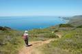 | Ridge Trail - Panorama Trail - Bluff Trail Loop This 8.7-mile loop in Andrew Molera State Park crosses a coastal ridge, bluff, and beach that are packed with amazing Big Sur views. |
 | McWay Falls This 0.6-mile hike looks out on a stunning Big Sur waterfall that pours 80 feet right on to the beach. |
 | Canyon Falls This 0.9-mile hike heads inland up McWay Creek past a picnic area in a redwood grove to a lovely little waterfall. |
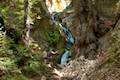
 | Partington Cove This 1.5 mile hike visits a cove and a secluded beach along the scenic Big Sur coast. The cove is accessed through a tunnel. |
 | Hare Creek Trail, Limekiln Trail, and Falls Trail This 2.65-mile hike in Limekiln State Park explores a trio of trails along lovely streams in redwood-lined canyons, reaching Limekiln Falls and historic lime kilns. |
 | Sand Dollar Beach This stunning hike of half a mile or more reaches two scenic overlooks as it descends to a long beach on the Big Sur coast. |
 | Jade Cove and Plaskett Rock Point This 1.5-mile hike along an ocean bluff visits a prominent peninsula and a small cove. |
 | Pacific Valley Bluff Trail This short out and back hike extends from Highway One to an ocean bluff with fantastic views of the Big Sur Coast. |
 | Salmon Creek Falls This short hike visits a fine 120-foot waterfall near the start of Salmon Creek Trail. |
 | Buckeye Trail This hike of 6.5 miles or more reaches incredibly ocean vistas and trail camps in the Silver Peak Wilderness. Connect Cruickshank Trail and Buckeye Trail for an excellent shuttle hike of 8.25 miles or more. |
 | Cruickshank Trail This hike into Silver Peak Wilderness starts with bold ocean views and crosses redwood groves to reach Upper Cruickshank Camp at a junction with Buckeye Trail, 5 miles round trip from Highway One. |
 | More Central Coast Hikes Explore other destinations along the California coast between Ventura and Monterey, including trails in Los Padres National Forest. |
 | Pfieffer Big Sur State Park Campground This large campground in the heart of Big Sur is spread out through oak and redwood groves along the Big Sur River. |
 | Andrew Molera State Park Trail Camp This trail camp is easy to reach (just a short walk in) with campsites in a meadow along the Big Sur River near Molera Beach. |
 | Limekiln State Park Campground This small Big Sur campground at the bottom of Limekiln Canyon has sites along a creek through a redwood grove and near the ocean, with access to trails up Limekiln Canyon. |
 | Kirk Creek Campground This outstanding 33-site campground in Los Padres National Forest has enormous ocean views from a bluff along the Big Sur coast. |
 | Plaskett Creek Campground This 45-site campground in Los Padres National Forest is positioned across Highway One from Sand Dollar Beach and Plaskett Rock Point on the coast of Big Sur. |
- Pfeiffer Beach on californiathroughmylens.com (opens in a new tab)
- Pfeiffer Beach on huffingtonpost.com (opens in a new tab)
- Pfeiffer Beach on jrabold.net (opens in a new tab)
- Pfeiffer Beach on campone.com (the concession for the day use area) (opens in a new tab)
- The official national forest webpage for Pfeiffer Beach Day Use (opens in a new tab)
Common Questions about Pfeiffer Beach in Los Padres National Forest (Big Sur)
- Is the trail open?
- Yes. You should expect to find that Pfeiffer Beach is open. There are no recent reports of trail closures. If you discover that the trail is closed, please help your fellow hikers by reporting a closure.
- Do I need a permit for this hike?
- Yes. National Forest Day Use Fee.
- How long is this hike?
- The hike to Pfeiffer Beach is a 0.2 mile out and back with 10 feet of elevation change.
- Are dogs allowed on this trail?
- Yes, dogs are allowed on Pfeiffer Beach. The trail is open to hikers, dogs.
- Is Pfeiffer Beach good for kids?
- Yes, this hike is likely suitable for children. It is relatively short (0.2 miles) with manageable elevation gain.
- Are there ocean views on this hike?
- Yes, Pfeiffer Beach offers views of the ocean.
- Where is the trailhead located?
- The trailhead for Pfeiffer Beach is located in Big Sur, CA.
Trailhead Address:
Sycamore Canyon Road
Big Sur, CA 93920
Trailhead Coordinates:
36.2382, -121.81353 - What are the driving directions to the start of the hike?
To get to the trailhead: Pfieffer Beach: You'll need to use your odometer to find the road to Pfieffer Beach. Sycamore Canyon Road breaks off the west side of Highway One, 1.1 miles south of the entrance to Pfieffer Big Sur State Park and 9.8 miles north of Julia Pfeiffer Burns State Park (1.8 miles north of Nepenthe Restaurant). The GPS coordinates of the intersection are 36.240215, -121.777226 (36° 14' 24.77"N 121° 46' 38.01"W). Turn down Sycamore Canyon Road, which is only marked with a yellow sign that reads, Narrow Road, No RVs - Trailers. Drive 2 1/4 miles down this paved winding road to the day use parking area at road's end. You will pass a reassuring plaque near the top of the road that reads, Pfieffer Beach - Two Miles. After the entry fee station, an overflow parking area is on your left. Continue straight to a second parking area (if you can find a place to park) where bathrooms and a few picnic tables are located near the start of the trail.
View custom Google Maps directions from your current location.
- Are there other trails near Pfeiffer Beach?
- Yes, you can find other nearby hikes using the Hikespeak Hike Finder Map.

Are dogs permitted?
Yes
They do NOT accept the America the Beautiful National Parks and Federal Recreational Lands Pass in place of the $10 fee. Maybe they did in the past, but I was just there on September 22, 2014 and they would not accept my pass.
Hi Kathy,
There are similar issues at Sand Dollar Beach in Los Padres NF and Limekln State Park (where they are rejecting annual state park passes). These three sites are operated by a concession with Parks Management Company, and their employees seem to ignore national and state park policies in favor of the company’s bottom line. The “America the Beautiful” National Parks and Public Lands Pass really should work for all national forest day use fees, regardless of the concession. California State Parks and the U.S. Forest Service need to change the way this other company is used.
[…] Pfeiffer Beach is a real gem tucked away at the end of Sycamore Canyon Road at Big Sur, California (south of Monterey). This spectacular beach is famous for its pink sand, formed by manganese garnet crystals that have washed down from the cliffs above. Look for ever-changing patterns of increasing pink sand as you walk north along the beach. A bonus to your walk is the rocky sea arch offshore – watch for the waves to come roaring through its keyhole arch. Don’t miss this hidden secret! Learn more at: https://www.hikespeak.com/trails/pfeiffer-beach-big-sur/ […]