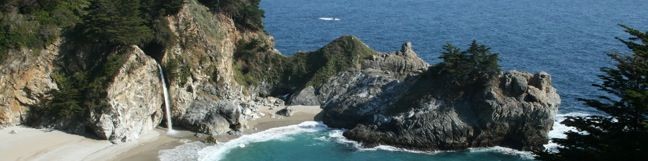
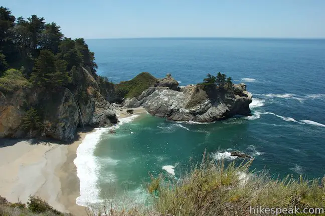
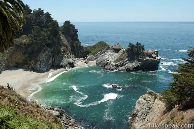
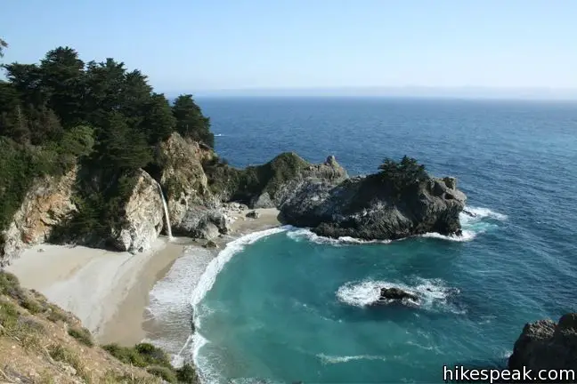
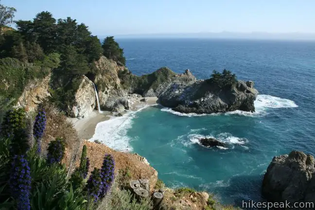
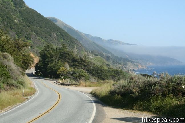
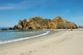
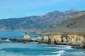
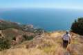
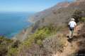
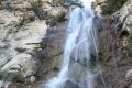
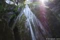
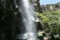
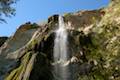
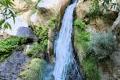
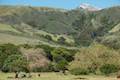
The overlook trail for McWay Falls is a must-stop for anyone taking the scenic drive up Highway One along the Big Sur Coast. The waterfall is stunning, dropping some 80 feet onto a pristine beach in an enchanting cove. It is a short 0.6-mile round trip hike to a viewpoint for McWay Falls, which can be reached directly from Highway One or from parking areas withing Julia Pfieffer Burns State Park.
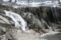
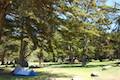
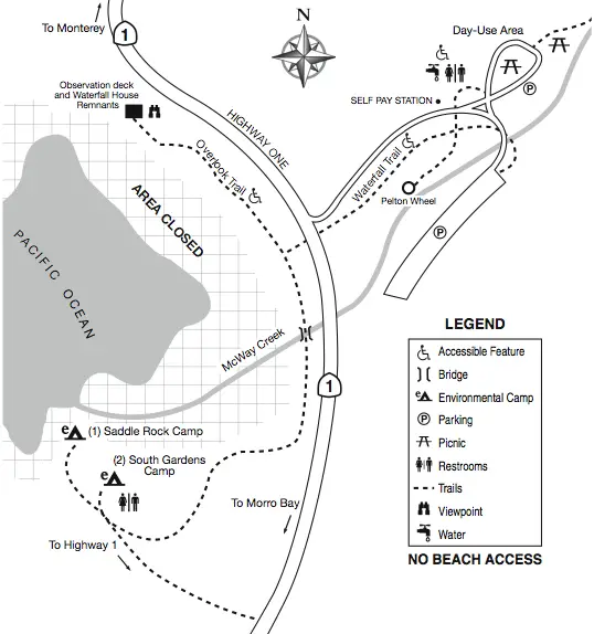
McWay Falls Overlook Trail can be accessed two different ways. Option one is to simply park along Highway One for free and start down the trail. You may also pull into Julia Pfeiffer Burns State Park and pay an entrance fee to walk a bit farther. This is a good option if you plan to spend more time in the park, hiking Canyon Trail for example, which travels inland up McWay Creek past a picnic area to the smaller Canyon Falls.
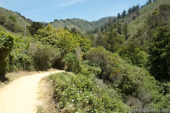
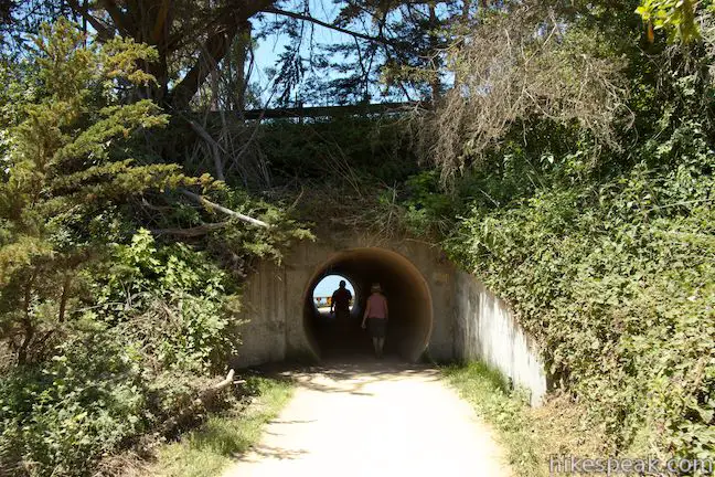
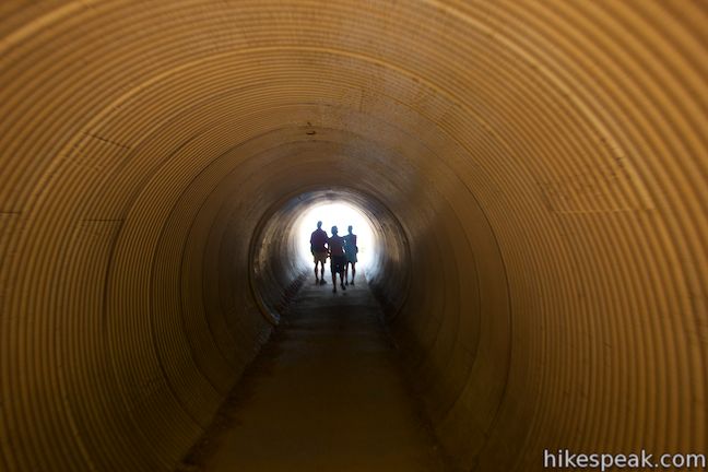
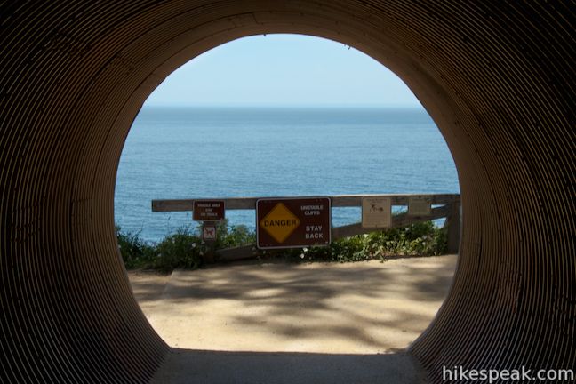
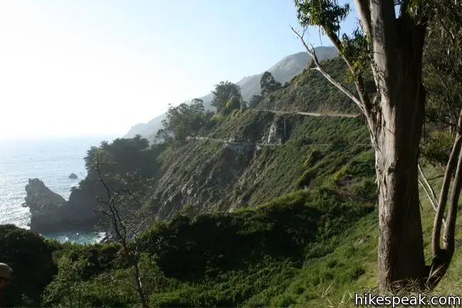
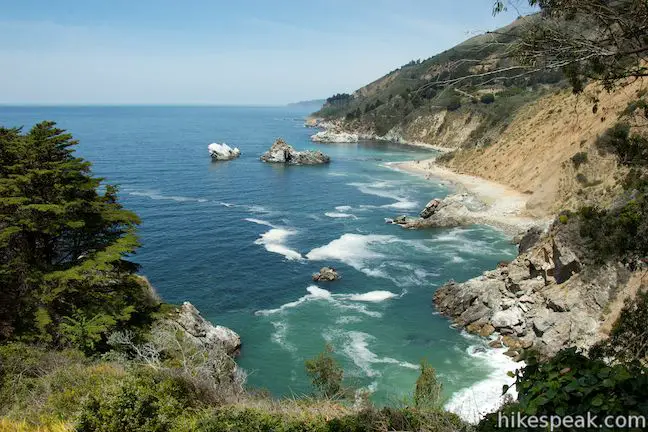
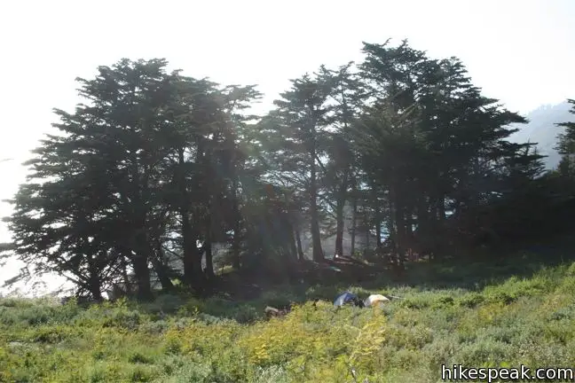
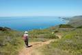
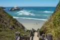
To get to Overlook Trail from the park parking lot, take the signed trail at the inside of the curve in the road between the upper and lower parking areas. Walk down the wide dirt trail and through a tunnel beneath Highway One. Turn right here, joining the trail on the west side of the highway. If you park along Highway One, simply find the trail on the west side of the highway just south of the park entrance. Walk down the trail past the tunnel and continue to views of McWay Falls.
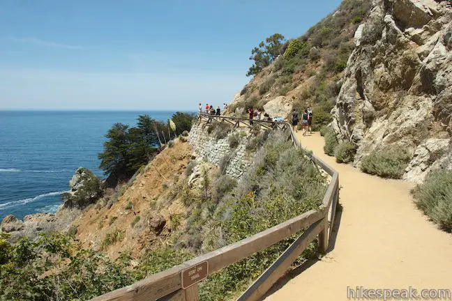
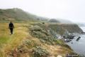
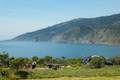
The trail follows cliffs around a cove to a point that faces McWay Falls. A lovely beach graces in the cove below the trail, but visitors are not allowed to access to this area, where the waterfall lands on the beach, so the entire cove remains natural and beautiful (A big fine is charged to anyone who gets caught down there).
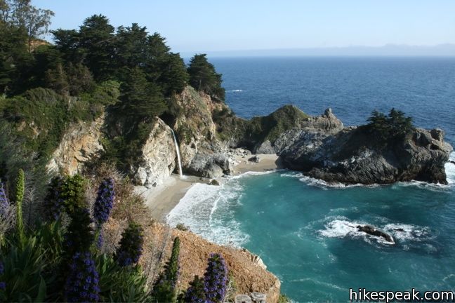
At the end of the short gradual trail, you will reach the best views of the falls and the stone foundation of a house built on the point north of the falls. The house was built in 1940 and later the land was donated to California State Parks. What a view the residents must have had!
The park has setup several informative panels in this area. One panel shows photos of McWay Falls prior to a massive 1983 landslide that occurred just north of here. The landslide dropped lots dirt into the ocean that flowed south and collected here, creating the beach in the cove by McWay Falls seen today. Prior to this, the waterfall dropped directly into the ocean. Over time, the beach may disappear again.

McWay Falls is so shockingly beautiful that you will just want to linger at the end of the trail and watch it fall.
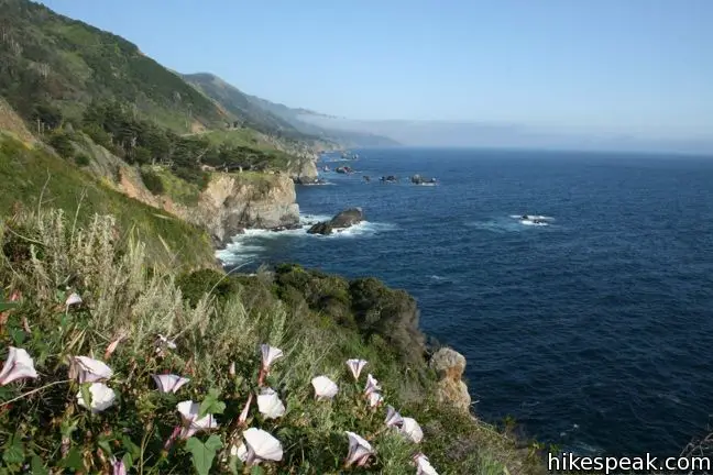
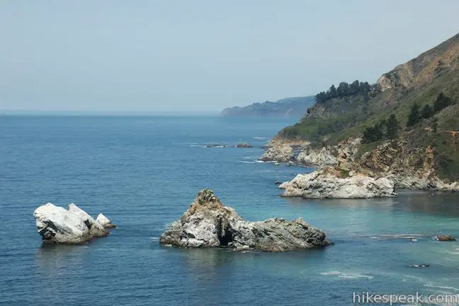
When you are done scoping out the falls, simply walk back the way you came. For those who want to hike farther, seek out a short path venturing south of the falls. Take this trail to rewarding views south down the coast. Additionally, two miles to the north is the 1.5-mile Partington Cove Trail, which visits a small beach and a tunnel-accessed cove. Dogs and bikes are not allowed. If you park along Highway One, no fee or permit is requires to visit McWay Falls, so get out and enjoy!
Directions to the Trailhead
- From Ragged Point, drive 37.2 miles north on Highway One to the well marked Julia Pfeiffer Burns State Park (60 miles north of Cambria).
- The park is 8.1 miles south of Nepenthe Restaurant in Big Sur.
- Park beneath the sycamores alongside Highway One and locate the trailhead on the west side of the road.
Trailhead Location
Trailhead address: Highway 1, Julia Pfeiffer Burns State Park, Big Sur, CA 93920
Trailhead coordinates: 36.1587, -121.67054 (36° 09′ 31.3″N 121° 40′ 13.94″W)
You may also view a regional map of surrounding Central Coast trails and campgrounds.


 | Canyon Falls This 0.9-mile hike heads inland up McWay Creek past a picnic area in a redwood grove to a lovely little waterfall. |
 | Partington Cove This 1.5 mile hike visits a cove and a secluded beach along the scenic Big Sur coast. The cove is accessed through a tunnel. |
 | Hare Creek Trail, Limekiln Trail, and Falls Trail This 2.65-mile hike in Limekiln State Park explores a trio of trails along lovely streams in redwood-lined canyons, reaching Limekiln Falls and historic lime kilns. |
 | Pfeiffer Beach This short walk reaches an absolutely stunning beach that's a classic feature of the Big Sur landscape. |
 | Big Sur River Gorge This half-mile off-trail hike ventures up the Big Sur River on a water-wading boulder-hopping adventure to a crystal clear pool that's a gorgeous Big Sur swimming hole. |
 | Pfeiffer Falls and Valley View This 2.4-mile hike is like two hikes in one, reaching a waterfall in a canyon of redwoods and a vista point overlooking the Big Sur River Valley. |
 | Nature Trail - River Path Loop This easy 0.55-mile loop explores woodlands along the Big Sur River and a redwood grove that includes the unique and impressive Proboscis Tree. The loop can be combined with the trail to Pfeiffer Falls and Valley View for a 3-mile trek. |
 | Ridge Trail - Panorama Trail - Bluff Trail Loop This 8.7-mile loop in Andrew Molera State Park crosses a coastal ridge, bluff, and beach that are packed with amazing Big Sur views. |
 | Pacific Valley Bluff Trail This short out and back hike extends from Highway One to an ocean bluff with fantastic views of the Big Sur Coast. |
 | Sand Dollar Beach This short hike to Big Sur's longest beach passes two scenic overlooks on the way to the sand for a hike of 0.5 miles (or more) round trip. |
 | Jade Cove and Plaskett Rock Point This 1.5-mile hike along an ocean bluff visits a prominent peninsula and a small cove. |
 | Salmon Creek Falls This short hike visits a fine 120-foot waterfall near the start of Salmon Creek Trail. |
 | Buckeye Trail This hike of 6.5 miles or more reaches incredibly ocean vistas and trail camps in the Silver Peak Wilderness. Connect Cruickshank Trail and Buckeye Trail for an excellent shuttle hike of 8.25 miles or more. |
 | Cruickshank Trail This hike into Silver Peak Wilderness starts with bold ocean views and crosses redwood groves to reach Upper Cruickshank Camp at a junction with Buckeye Trail, 5 miles round trip from Highway One. |
 | More Central Coast Hikes Explore other destinations along the California coast between Ventura and Monterey, including trails in Los Padres National Forest. |
 | Tangerine Falls in the Los Padres National Forest This 2.5-mile hike visits a beautiful waterfall on the edge of Los Padres National Forest near Santa Barbara. |
 | Rose Valley Falls in the Los Padres National Forest This 1-mile round trip trail leads to the lower tier of a lovely two-tier 300-foot waterfall. |
 | Nojoqui Falls This short 0.65-mile hike visits an 80-foot tall fern-lined waterfall. |
 | Sturtevant Falls in the San Gabriel Mountains This 3.3-mile hike visits a 60-foot waterfall and a lush cottage-lined canyon. |
 | Fish Canyon Falls in the San Gabriel Mountains This 4.8-mile round trip hike leaves from an active rock quarry and progresses up a beautiful canyon to a mesmerizing multi-tiered waterfall. |
 | Escondido Falls in the Santa Monica Mountains This 3.8-mile out and back hike visits a 200-foot waterfall that is split into two tiers. The upper tier is 150 feet tall and stunning after a rainstorm. |
 | Tokopah Falls in Sequoia National Park This 4.2-mile hike reaches the base of the tallest waterfall in Sequoia National Park. |
 | Lower Yosemite Fall in Yosemite National Park This electrifying 1.2-mile hike delivers visitors to the base of the tallest waterfall in North America. |
 | Darwin Falls in Death Valley This 2-mile hike visits a refreshing year-round waterfall on the western edge of Death Valley. |
 | Pfieffer Big Sur State Park Campground This large campground in the heart of Big Sur is spread out through oak and redwood groves along the Big Sur River. |
 | Andrew Molera State Park Trail Camp This trail camp is easy to reach (just a short walk in) with campsites in a meadow along the Big Sur River near Molera Beach. |
 | Limekiln State Park Campground This small Big Sur campground at the bottom of Limekiln Canyon has sites along a creek through a redwood grove and near the ocean, with access to trails up Limekiln Canyon. |
 | Kirk Creek Campground This outstanding 33-site campground in Los Padres National Forest has enormous ocean views from a bluff along the Big Sur coast. |
 | Plaskett Creek Campground This 45-site campground in Los Padres National Forest is positioned across Highway One from Sand Dollar Beach and Plaskett Rock Point on the coast of Big Sur. |
- McWay Falls on wilkipedia.org (opens in a new tab)
- McWay Falls on mcwayfalls.com (opens in a new tab)
- McWay Falls on atlasobscura.com (opens in a new tab)
- McWay Falls on hikinginbigsur.com (opens in a new tab)
- McWay Falls on socalhiker.net (opens in a new tab)
- McWay Falls on californiathroughmylens.com (opens in a new tab)
- McWay Falls on world-of-waterfalls.com (opens in a new tab)
- McWay Falls on waterfallswest.com (opens in a new tab)
- The official website for Julia Pfeiffer Burns State Park (opens in a new tab)
Common Questions about McWay Falls in Julia Pfeiffer Burns State Park
- Is the trail open?
- Yes. You should expect to find that Overlook Trail to McWay Falls is open. There are no recent reports of trail closures. If you discover that the trail is closed, please help your fellow hikers by reporting a closure.
- Do I need a permit for this hike?
- Yes. Free parking on Highway One / Entrance fee for Julia Pfeiffer Burns State Park.
- How much time does this hike take?
- It takes approximately 15 minutes to hike Overlook Trail to McWay Falls. Individual hiking times vary. Add extra time for breaks and taking in the views.
- How long is this hike?
- The hike to Overlook Trail to McWay Falls is a 0.6 mile out and back with 50 feet of elevation change.
- Are dogs allowed on this trail?
- No, dogs are likely not allowed on Overlook Trail to McWay Falls. The trail is primarily open to hikers.
- Is Overlook Trail to McWay Falls good for kids?
- Yes, this hike is likely suitable for children. It is relatively short (0.6 miles) with manageable elevation gain.
- Will I see a waterfall on this hike?
- Yes, Overlook Trail to McWay Falls features a waterfall.
- Are there ocean views on this hike?
- Yes, Overlook Trail to McWay Falls offers views of the ocean.
- Where is the trailhead located?
- The trailhead for Overlook Trail to McWay Falls is located in Big Sur, CA.
Trailhead Address:
Highway 1
Big Sur, CA 93920
Trailhead Coordinates:
36.1587, -121.67054 - What are the driving directions to the start of the hike?
To get to the trailhead: From Ragged Point, drive 37.2 miles north on Highway One to the well marked Julia Pfeiffer Burns State Park (60 miles north of Cambria). The park is 8.1 miles south of Nepenthe Restaurant in Big Sur. Park beneath the sycamores alongside Highway One and locate the trailhead on the west side of the road.
View custom Google Maps directions from your current location.
- Are there other trails near Overlook Trail to McWay Falls?
- Yes, you can find other nearby hikes using the Hikespeak Hike Finder Map.

13 Comments on McWay Falls in Julia Pfeiffer Burns State Park
What hikers are saying:
✨ Generated summary of user commentsHikers describe this destination as one of the most beautiful places in the world, where the waterfall, sea, and flowers converge in a single view. Alexandra warns that illegal access is strictly monitored, making it essential to respect the boundaries of the state park.
“Mcway Falls is wonderful!” Jump to comment ↓
Mcway Falls is wonderful! I visited Julia Pfieffer State Park with my wife, and spend time there. We walked along the walkway, and we’re lucky enough to saw sunset from there. Seeing waterfall, sea, waves, rocks, trees, flowers, wow they’re come together in one place. It’s one of beautiful places in the world. I want to explore the place again.
My wife and i will go to California the next mounth of July.We’ll travel the Hwy 1 from S. Francisco to Los Angeles. We want visit Mcway Falls. Could you send us the address where we can stop our car?
There are other interesting places to see?
I’m sorry for my English is not good. Thank you very much,
Enzo Bonacina.
Enjoy your trip. The address is 65100 Cabrillo Highway (Highway One), Julia Pfeiffer Burns State Park, Big Sur, CA 93920
There are several other great trail on Highway One, including the nearby trail to Partington Cove, which you can find on this list of hikes in the Big Sur area.
Are there campgrounds close to McWay Falls?
Hi – There are two “Environmental Campsites” in Julia Pfeiffer Burns State Park (more info) located near McWay Falls, but they seem to be constantly booked. You will have better luck looking for a camp site in Limekiln State Park or in the surrounding national forest.
the fine is roughly $400/person. and completely worth it.
My boyfriend received a parking ticket there but lost the ticket. Is there someone we can contact?
You might want to contact the local police department there.
Is the hwy 1 open?? Going from L.A
Yes finally as of July 2018, after a 14 month closure !
I just seen a video of a hiker on TikTok going to the waterfall some people were asking him if it was illegal and he said yes and someone else responded monkey see monkey do, hopefully people don’t try doing the same ?
[…] 2. McWay Falls […]
[…] McWay Falls is one of the most photographed places in Big Sur. You absolutely cannot miss this one. If you are a nature lover, you are probably wondering if you can hike down to the falls. Unfortunately, it is illegal to walk down to the bottom due to the natural dangers presented here. However, there is plenty of opportunity for panoramic views from above. […]