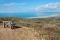
Montaña de Oro State Park has dramatic ocean bluffs and summits with sweeping views. The park covers over 8,000 acres and has 7 miles of undeveloped coastline, making it a rare treasure on the California Coast. One road leads into the park, entering from the town of Los Osos to the north, which is just west of the city of San Luis Obispo. Visitors can stay overnight at a 50-site campground at the center of the park.
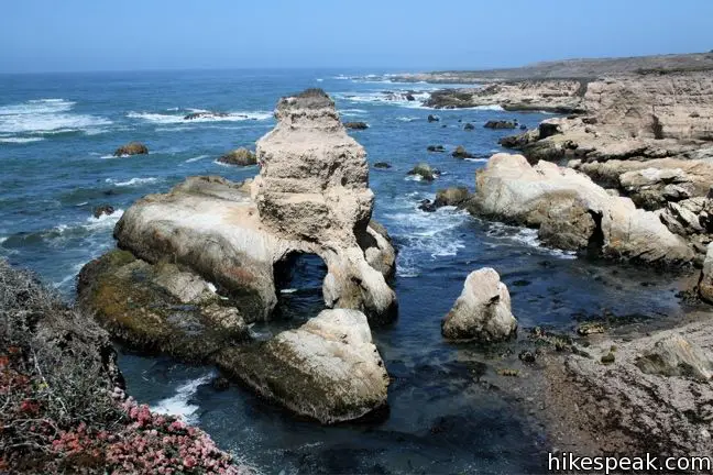
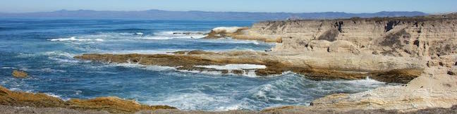
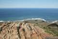
First time visitor should be sure to hike the Bluff Trail, which crosses sea cliffs and coves on the impressive oceanfront.
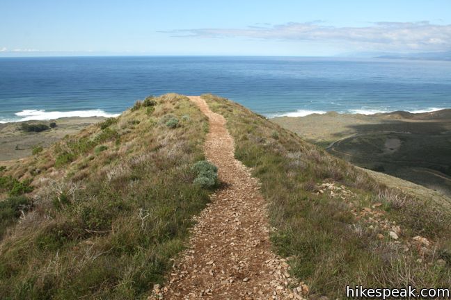
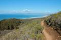
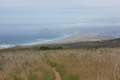
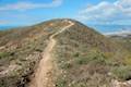
With more energy, you can hike to a mountaintop like Valencia Peak, Oats Peak, or Hazard Peak. Every summit trail offers great ocean views. Each peak also looks inland across the Irish Hills, which spread beyond the eastern boundary of Montaña de Oro State Park. Hazard Peak in particular provides nice views north up the coast toward Morro Bay and beyond.
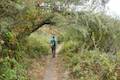
Generally speaking, mountain bikers are allowed on trails on the north side of the park, but that seems to be expanding as Oats Peak is now open to bikes as well. Islay Creek Trail and Hazard Peak Trail and also popular mountain bike routes and the Bluff Trail presents an easier ride. Dogs are not allowed on trails in Montaña de Oro State Park.
Hikes in Montaña de Oro State Park
The list below contains 12 hikes in Montaña de Oro State Park as well as two additional hikes on the edge of the park (one hike in Morro Dunes Ecological Reserve rises to a viewpoint within Montaña de Oro State Park and another trail travels down the remote coast to the south toward Point Buchon Trail and relies on a trailhead within Montaña de Oro State Park). These Montaña de Oro State Park hiking trails are listed from north to south.
| Trail | Description | Distance | Location |
|---|---|---|---|
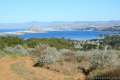 135 135 | Morro Dunes Ecological Reserve This lollipop loop serves up panoramic views over Morro Bay as it climbs from Los Osos to Montaña de Oro State Park. | 2.6 miles 800 feet | 35.308454, -120.843157 |
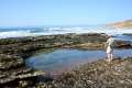 145 145 | Hazard Canyon Reef This short hike in Montaña de Oro State Park descends an oceanfront ravine to a rocky shoreline graced with engaging tide pools. | 1 mile 100 feet | 35.285512, -120.881105 |
 145 145 | Hazard Peak via Bloody Nose Trail, Hiedra Trail, and Hazard Peak Trail This hike rises through a eucalyptus grove and views of Morro Bay to a panoramic summit in Montaña de Oro State Park. | 5.55 miles 950 feet | 35.2854, -120.8801 |
 148 148 | South Dune Trail – Bloody Nose Trail – Hiedra Trail – Hazard Peak Trail Loop This four-trail loop through dunes and eucalyptus trees rises to lovely coastal views. | 2.67 miles 310 feet | 35.277106, -120.884546 |
 150 150 | Hazard Peak Trail This out and back hike in Montaña de Oro State Park ascends coastal ridges to a 1,076-foot summit with panoramic views that include a dynamic perspective of Morro Bay. | 6 miles 950 feet | 35.277106, -120.884546 |
 155 155 | Hazard Peak - Islay Creek Loop This loop in Montaña de Oro State Park continues beyond Hazard Peak deeper into the Irish Hills before circling back to the coast on Islay Creek Trail. | 9.2 miles 1,00 feet | 35.277106, -120.884546 |
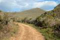 160 160 | Islay Creek Trail This easy out and back hike in Montaña de Oro State Park follows a wide trail up a coastal canyon flanked by thousand-foot peaks, passing a small waterfall to reach an abandoned barn. | 6 miles 300 feet | 35.276412, -120.885504 |
 164 164 | Reservoir Flats Trail This loop delivers fine ocean and canyon views as it explores the bottom of Islay Creek Canyon in Montaña de Oro State Park. | 2 miles 200 feet | 35.273872, -120.88553 |
 167 167 | Oats Peak This out and back hike reaches a panoramic summit that looks down over Montaña de Oro State Park. | 10.8 miles 1,325 feet | 35.273872, -120.88553 |
 170 170 | Valencia Peak This out and back hike summits a 1,347-foot peak with panoramic views over Montaña de Oro State Park. | 4.5 miles 1,275 feet | 35.272858, -120.888755 |
 180 180 | Bluff Trail (in Montaña de Oro State Park) This out and back hike of around three miles tours tide pools, beaches, and impressive cliffs along a picturesque coastline. | 1 - 5 miles 90 - 140 feet | 35.2728, -120.8887 |
 183 183 | Rattlesnake Flats Trail – Badger Trail – Bluff Trail Loop This loop offers a twist on the Bluff Trail, going along and just above the coast of Montaña de Oro State Park. | 1.65 miles 150 feet | 35.272858, -120.888755 |
 188 188 | Coon Creek Trail This out and back hike ventures up a coastal canyon at the south end of Montaña de Oro State Park. | 5 miles 250 feet | 35.257927, -120.886988 |
 190 190 | Point Buchon This short scenic loop or longer out-and-back hike explores the beautiful coastline south of Montaña de Oro State Park. | 1.33 - 6.8 miles 75 feet | 35.257964, -120.887483 |
Or view Central Coast trails and campgrounds in a larger map

7 Comments on Trails in Montaña de Oro State Park
What hikers are saying:
✨ Generated summary of user commentsHikers find the seasonal wildflower displays beautiful, though poppy abundance fluctuates based on how dry the winter was. This trail requires careful planning for pet owners because dogs are not allowed on the trails or beaches, excluding Spooner’s Cove beach. Steven notes that dogs must stay on a leash within campsites and park roads, and they cannot be left unattended.
When are the poppies/wild flowers blooming?
Should be many wildflowers now, though poppies may be scarcer this year because they like drier winters, (which this last was NOT.)
Are dogs allowed in the park?
No, dogs are not allowed on park trails.
DOGS are permitted in campsites and on park roads and must be on a six-foot maximum leash held by an adult. Dogs are NOT ALLOWED on the trails or beach, except for Spooner’s Cove beach. Dogs may not be left alone in the campsite and must be kept in a tent or vehicle at night. Please pick up after your pet. https://www.parks.ca.gov/?page_id=592
Thanks for adding clarity!
Is there backpacking with water available here?