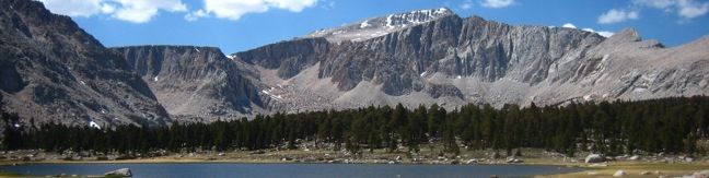
Rising to 14,042 feet, Mount Langley is less than five hundred feet shorter than Mount Whitney but receives far fewer visitors. While the lottery to get a permit for Mount Whitney can be challenging and competitive, Mount Langley’s hikers can easily get a free permit on the day of their hike. The summit provides expansive views, solitude, and a deep feeling of accomplishment.
At least eleven miles of hiking lie between Horseshoe Meadow and the top of Mount Langley. The trek be attempted as a fatiguing 22-mile day hike, or as a three-day affair with backcountry camping beside the beautiful Cottonwood Lakes. Langley is considered an “easy 14er” (though still a bit tougher than Whitney) and the trail to the top is more tiring than technically challenging. The marathon hike through thin air provides a worthy adversary and great rewards.
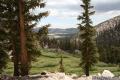
The first 7.5 miles of the hike are along Cottonwood Lakes Trail which is gradual and scenic, climbing 1,500 feet over 6.5 miles before a tougher ascent of 800 feet to New Army Pass. Langley is in sight and the path is clear.
Descend from the pass and break east off New Army Pass Trail, hugging the high end of the slope. Frustratingly, you are forced to give up three hundred feet of the elevation you worked so hard to climb. The only way to avoid the extra elevation is to hike up Old Army Pass instead, which is a less-maintained trail that can require a tricky snow climb.
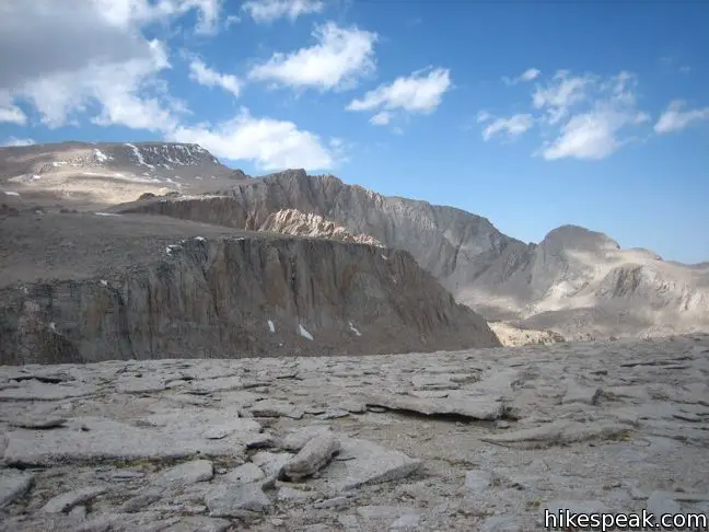
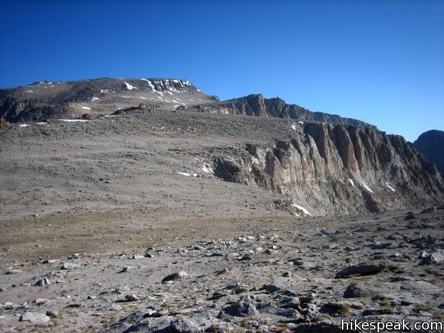
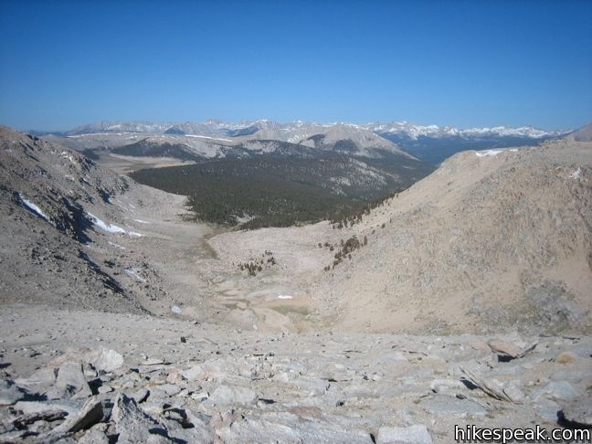
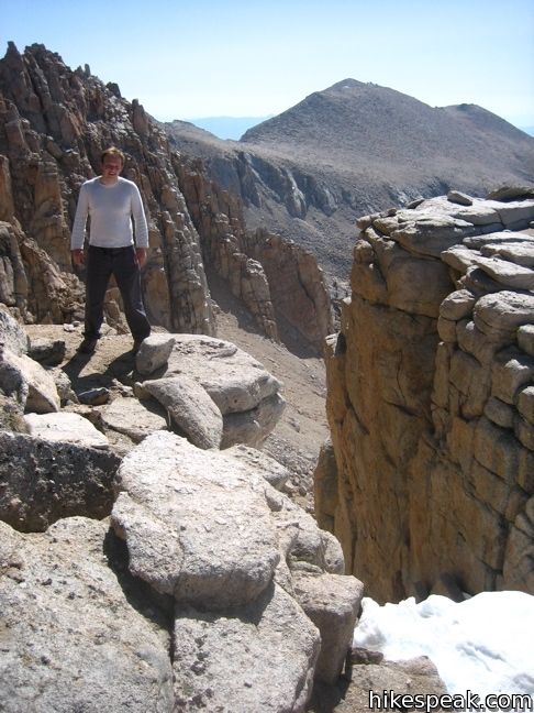
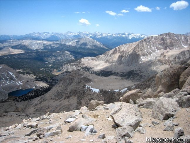
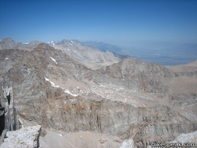
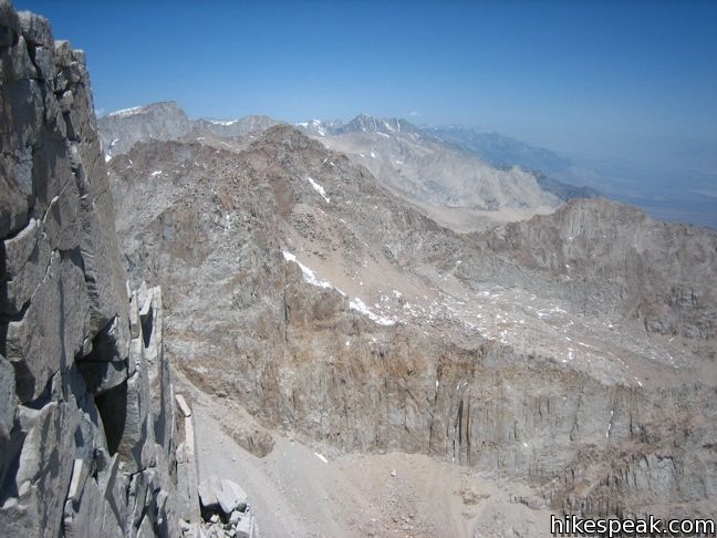
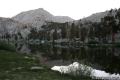
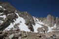
Beyond the passes, a worn path makes its way up to a ridgeline populated by rock towers. Beyond the towers, lies a barren slope of sandy gravel. The so-called Langley Plateau is much longer than it appears from the pass and the ridge offers a truer view of the distance to Langley.
Set out for the summit across the plateau. While an established trail may does not lead to the summit, the National Park Service has created a marked route no minimize the number of paths across this fragile landscape. Follow the established route as best you can up the mountain.
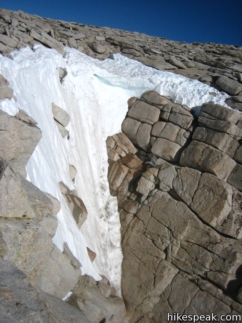
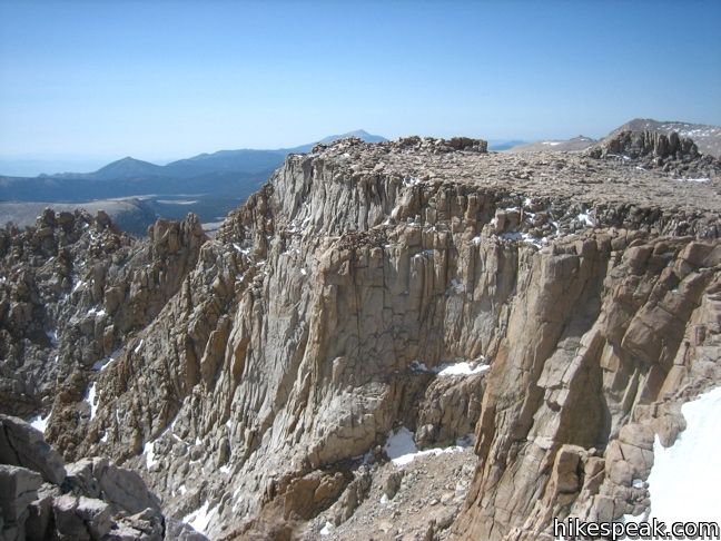
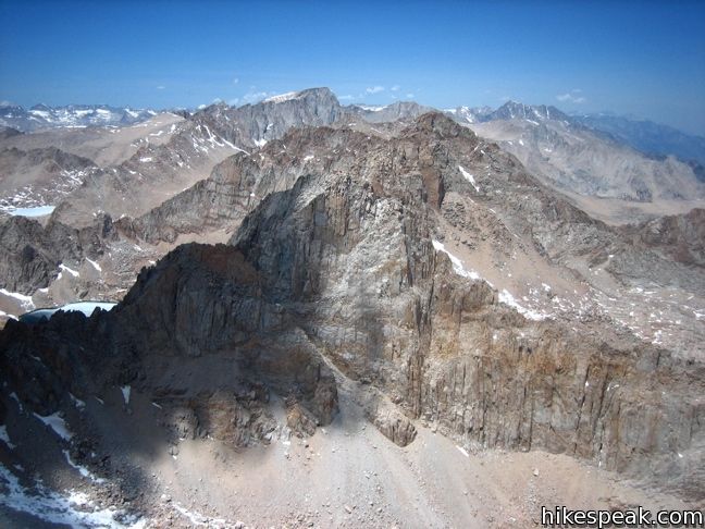
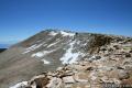
Beneath the summit, the easy-to-cross terrain gives way to a rock crown that requires a couple hundred feet of class three scrambling. Were this climb somewhere other than 14,000 feet above sea level, it would likely not be a challenge, but after the long slog, this point forces hikers to gather courage and preserver. The east side of the crown is steep and has the potential be covered in snow even in summer. Make your way west until you spot a channel that looks good for climbing and scramble up over the rocks.
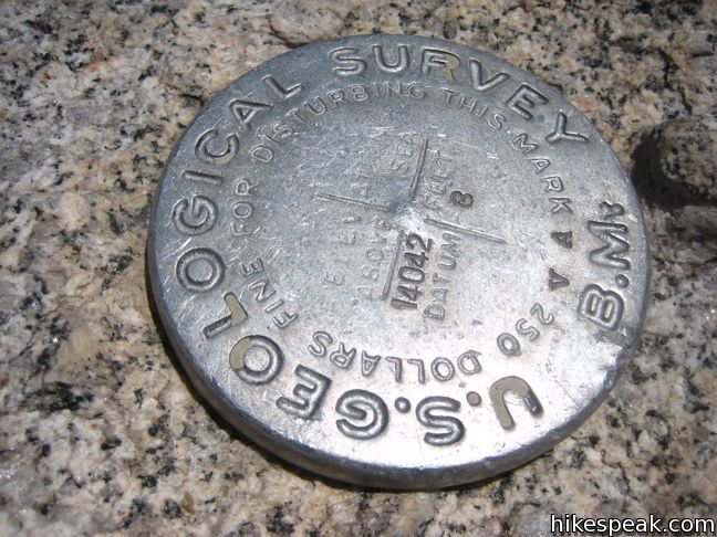
Above the climb, it is just a gradual walk to the high point at the northeast end of the summit. When you find the USGS marker and register, you have made it to the top.
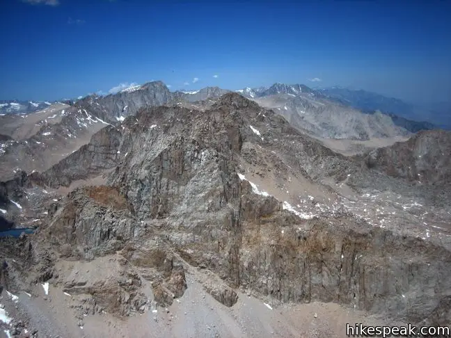
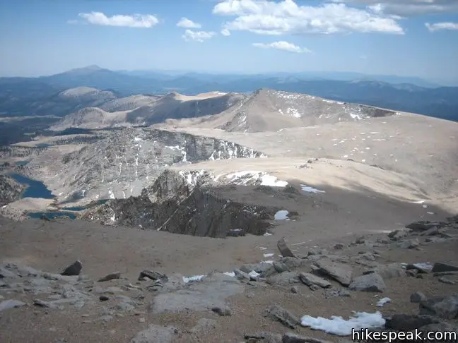
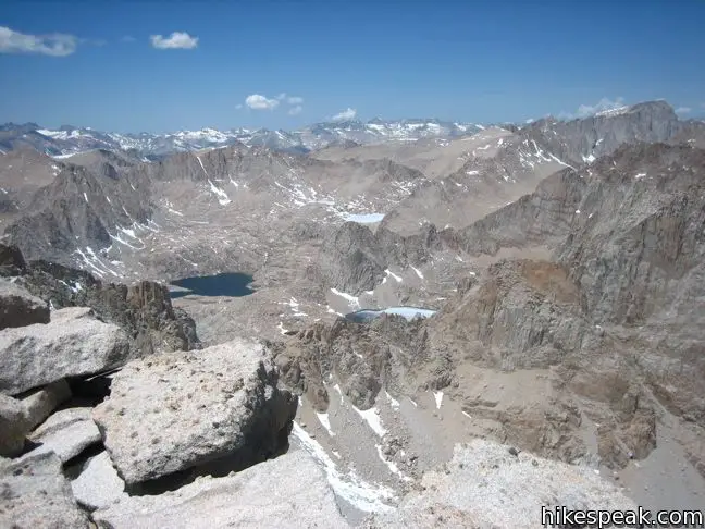
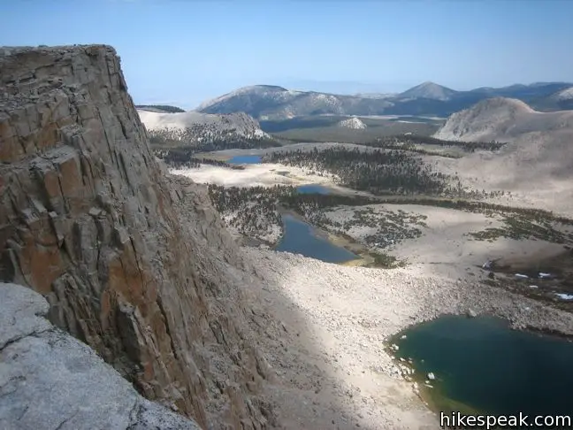
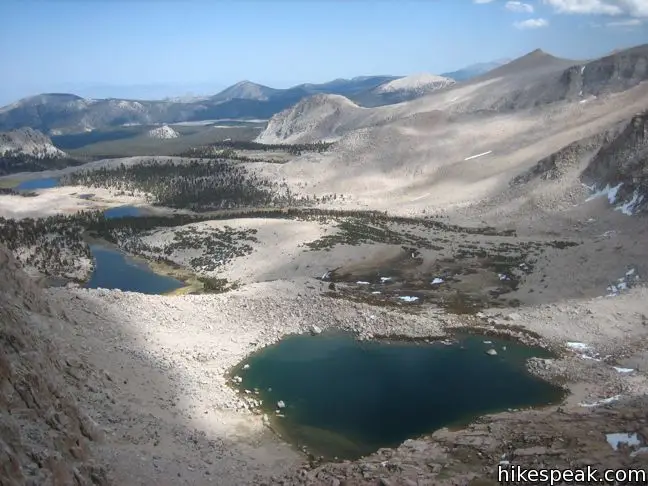
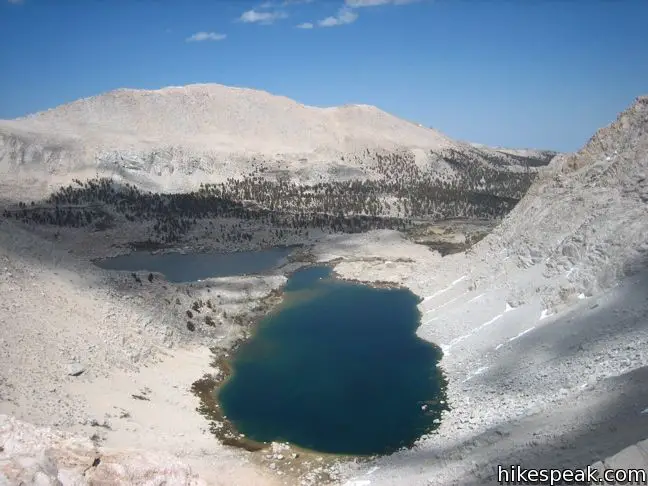
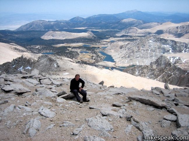
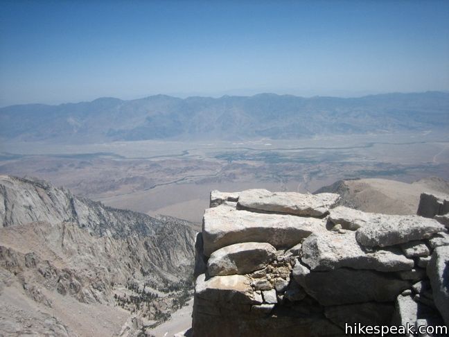
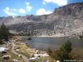
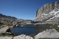
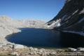
To the north and east, the mountain drops away down shear cliffs. The views are electrifying. Mount Whitney stands boldly to the north and other prominent pinnacles fill the panorama. To the northwest, the well named Sky Blue Lake lies in a mountain cradle in front of Mount Pickering. No California mountain south of Langley is any taller so you can stare out in that direction for days. To the west, the backcountry of Sequoia National Park spreads out toward the snow-capped Great Western Divide. If you make it to the top, congratulations! Proudly sign the register and know that you have seen sights few ever will.
Mount Langley sits on the border of Sequoia National Park and the John Muir Wilderness at the heart of the Sierra Nevada Mountains. This 22-mile hike with 4,000 feet of elevation is sure to be a highlight of any hikers resume. If anyone asks why you are setting out on such a strenuous hike, answer as John Muir would have, “The mountains are calling and I must go.”
- Review Cottonwood Lakes Trail for more details on the early portion of the hike, as well as a word on trailhead quotas and other information you should know before making the ascent on Langley.
Directions to the Trailhead
- It takes half an hour to ascend from the city of Lone Pine to the trailhead campgrounds.
- From Route 395 in Lone Pine, turn west at the traffic light on to Whitney Portal Road.
- After three miles, turn left on Horseshoe Meadow Road.
- Drive twenty miles up mountain switchbacks to the end of the road at Horseshoe Meadow.
- Turn right, following signs for Cottonwood Lakes and park at the trailhead.
Trailhead Location
Trailhead address: Horseshoe Meadows Road, Inyo National Forest, Lone Pine, CA 93545
Trailhead coordinates: 36.4532, -118.1699 (36° 27′ 11.5″N 118° 10′ 11.6″W)
View Eastern Sierra in a larger map
Or view a regional map of surrounding Sierra Nevada trails and campgrounds.


 | Cottonwood Lakes This trail through lake-filled Cottonwood Basin provides a 10-mile round trip day hike to Long Lake and a 7.5-miles one-way trek to New Army Pass a 12,300-foot gateway to the eastern Sierra including nearby Mount Langley. |
 | Old Cottonwood Creek Trail This 8 to 9-mile day hike follows a secluded trail through mountain meadows to the South Fork Lakes and Cirque Lake. |
 | Cirque Peak This 12,900-foot summit can be reached via off-trail ascents from New Army Pass, Cirque Lake, and Chicken Spring Lake. |
 | Cottonwood Pass This 7-mile round trip trail ascends 1,200 feet to an 11,200-foot pass and a junction with the Pacific Crest Trail, with access to Golden Trout Wilderness and Sequoia National Park. |
 | Lower Soldier Lake This 19.2-mile loop crosses Cottonwood Pass and New Army Pass to visit a beautiful lake that is an ideal camping spot for backpackers heading higher and deeper into the Sierra. |
 | Sky Blue Lake This hike extends beyond Lower Soldier Lake up Miter Basin to a deep blue lake surrounded by towering peaks. |
 | Primrose Lake This sidetrek visits a lake between Miter Basin and Mount Pickering en route to Sky Blue Lake. |
 | Mount Pickering This 13,485-foot summit west of Mount Langley offers more excellent sierra views. |
 | More trails in the Sierra Nevada Mountains Explore other destinations in Sequoia National Park and the rest of the range. |
 | Horseshoe Meadow Campgrounds This pair of campgrounds offer 40 sites and serve as a great base for the Cottonwood Pass and Cottonwood Lakes trails. |
- Mount Langley on Bob Burd's Trip Reports (opens in a new tab)
- Mount Langley on summitpost.org (opens in a new tab)
- Mount Langley on wikipedia.org (opens in a new tab)
- Mount Langley in The High Sierra: Peaks, Passes, and Trails by R. J. Secor (opens in a new tab)
- Trail and campground status page for the Mount Whitney Ranger District of Inyo National Forest (opens in a new tab)
- Inyo National Forest bear canister page (opens in a new tab)
- A National Park Service flyer about the Mount Langley Route (opens in a new tab)
- The official website for Inyo National Forest (opens in a new tab)
Common Questions about Mount Langley in Sequoia National Park
- Is the trail open?
- Yes. You should expect to find that Cottonwood Lakes Trail & Mount Langley Ascent is open. There are no recent reports of trail closures. If you discover that the trail is closed, please help your fellow hikers by reporting a closure.
- Do I need a permit for this hike?
- Yes. National Forest Wilderness Permit and bear canister required for overnight trips.
- How much time does this hike take?
- It takes approximately 11 hours 30 minutes to hike Cottonwood Lakes Trail & Mount Langley Ascent. Individual hiking times vary. Add extra time for breaks and taking in the views.
- How long is this hike?
- The hike to Cottonwood Lakes Trail & Mount Langley Ascent is a 22 mile out and back with 4000 feet of elevation change.
- Are dogs allowed on this trail?
- No, dogs are likely not allowed on Cottonwood Lakes Trail & Mount Langley Ascent. The trail is primarily open to hikers.
- Is Cottonwood Lakes Trail & Mount Langley Ascent a difficult hike?
- This hike should be considered strenuous. Hikers should be prepared for a workout covering 22 miles and 4000 feet of climbing.
- Does this trail go to a summit?
- Yes, Cottonwood Lakes Trail & Mount Langley Ascent reaches a summit with panoramic views.
- Where is the trailhead located?
- The trailhead for Cottonwood Lakes Trail & Mount Langley Ascent is located in Lone Pine, CA.
Trailhead Address:
Horseshoe Meadows Road
Lone Pine, CA 93545
Trailhead Coordinates:
36.4532, -118.1699 - What are the driving directions to the start of the hike?
To get to the trailhead: It takes half an hour to ascend from the city of Lone Pine to the trailhead campgrounds. From Route 395 in Lone Pine, turn west at the traffic light on to Whitney Portal Road. After three miles, turn left on Horseshoe Meadow Road. Drive twenty miles up mountain switchbacks to the end of the road at Horseshoe Meadow. Turn right, following signs for Cottonwood Lakes and park at the trailhead.
View custom Google Maps directions from your current location.
- Are there other trails near Cottonwood Lakes Trail & Mount Langley Ascent?
- Yes, you can find other nearby hikes using the Hikespeak Hike Finder Map.

19 Comments on Mount Langley in Sequoia National Park
What hikers are saying:
✨ Generated summary of user commentsThis trail provides a rewarding experience for those seeking a rugged mountain challenge. While the route can be tough to navigate, Benjamin mentions that cairns now mark an official path toward the summit. Hikers find the effort well worth the struggle, though finding sheltered camping is best done near the lakes rather than beyond the pass.
“I did this hike at the beginning of November and it was magnificent!” Jump to comment ↓
[…] Website HikeSpeak.com […]
Attempted to reach Langley summit on 5th and fell short by a mile or so. We couldn’t figure out the best way to go up. two of my fellow hikers reached the plateau but didn’t know where to go after that. Oh well, it was my first attempt, may be next time.
They’ve added a bunch of cairns to mark an “official” way up to the summit this summer.
We got up to the summit for the second time this summer. The first time, we took New Army up and down, it was towards the end of May and snow was a bit of an issue.
This past Saturday, 8/17, we went up New Army and came down Old Army. Made it to the summit but it was tough going once you get to around 13,000 ft.
Well worth the challenge, your article captures it perfectly!
provided I spend a night acclimatizing, is it possible to hike from the Cottonwood Lakes Trailhead to High Lake in one day, or even less than one day?
You can certainly make it to High Lake in less than a day. If you’re backpacking, it will probably take 4 hours or so to get to High Lake, unless you’re really rushing. Take your time and enjoy the scenery. Beyond New Army Pass, there aren’t any sheltered places to camp on the route to Mt. Langley, so it’s best to stay by the lakes. Have a great hike!
Do you know when the campgrounds open this year at Mt. Langley?
We have a permit for Memorial weekend 2014 and would like to hear any report regarding the current snow conditions. Our plan is to hike to High Lake the first day and then summit the next.
hey, if you go, post your trip report, i was thinking of going the last week of may, would like to know if there is still a lot of snow
[…] Early AM – Mt. Langley summit attempt […]
What an informative post! From the looks of the photos, it seems like a trail I would like to try out soon! Thanks for sharing!
whats the weather like in September???
September can be a great time to hike in this area with high temps and minimal snow.
What map (or maps) should I get to do this route? A few friends and are going to attempt this hike next weekend.
We are up at Cottonwood Lakes to fly fish the coming weekend around July 1st – Anyone who has been up there recently? How are the conditions? We think about doing a day hike up Mt. Langley from the lakes… would be great to get some feedback about the current conditions. Thx! Kurt
Hey, I’m planning on going there in 2 weeks. How was the snow when you were there in June?
Thanks!
Greg
[…] latter thought to be more majestic. Additionally, if you’re interested in a summit climb of Mt. Langley you’ll want to take the […]
[…] Hikes Peak – Mt Langley Hike […]
I did this hike at the beginning of November and it was magnificent! I wrote about my day here: https://adventuretramp.com/2019/12/18/mt-langley/