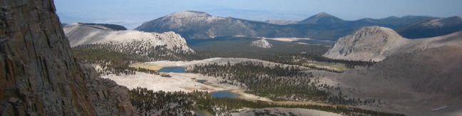
Cottonwood Lakes Trail provides a scenic romp through the Southeastern Sierra with alpine lakes and mountain views. Located south of Mount Whitney and west of the city of Lone Pine, the trail travels through the Golden Trout Wilderness and the John Muir Wilderness to end at the border of Sequoia National Park. This is a superb trail for day hikers and backpackers alike.
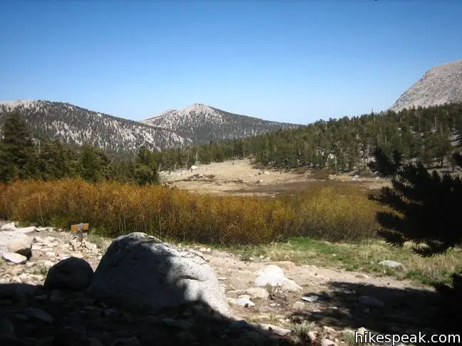
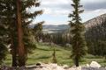
The first mile passes through a pleasant pine forest and heads down to a crossing of the South Fork of Cottonwood Creek (the trail is allowed to go downhill because it starts at 10,000 feet above sea level). You can rock hop if the water is low. Otherwise, utilize the well placed log to bridge the creek. Just past the creek crossing is an unmarked and easy to miss junction with Old Cottonwood Creek Trail.
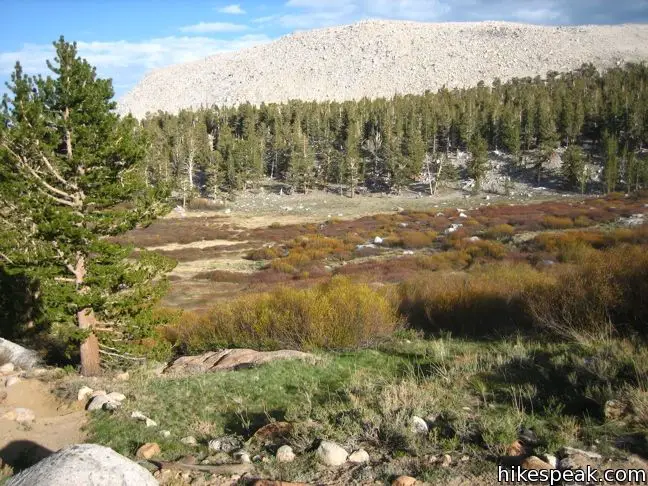
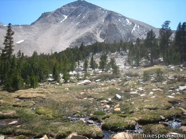
Cottonwood Lakes Trail continues straight ahead on a gradual course into the John Muir Wilderness. Every step brings you closer to the pleasures of Cottonwood Basin. Let Muir’s words encourage you forward:
Climb the mountains and get their good tidings. Nature’s peace will flow into you as sunshine flows into trees. The winds will blow their own freshness into you, and the storms their energy, while cares will drop off like autumn leaves.
The trail passes a turnoff for Muir Lakes Trail, the route for those wishing to climb Old Army Pass en route to the 14,042-foot summit of Mount Langley. The trail was built at the end of the nineteenth century and is now under-maintained. The snow-covered pass has the potential to be treacherous. Some hikers still use the old pass, but most now prefer New Army Pass at the end of Cottonwood Lakes Trail, even though it is a higher crossing.
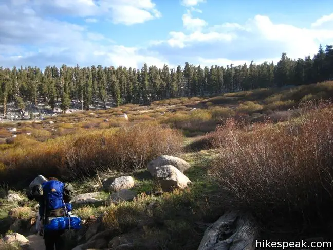
Several other use trails branch off from Cottonwood Lakes Trail, taking hikers and fishermen to other lakes in basin. One example is South Fork Lakes Trail, which spins off the main track beneath the first Cottonwood Lake, and reaches South Fork Lake after one mile.

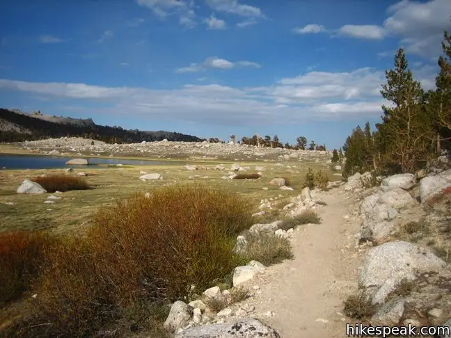
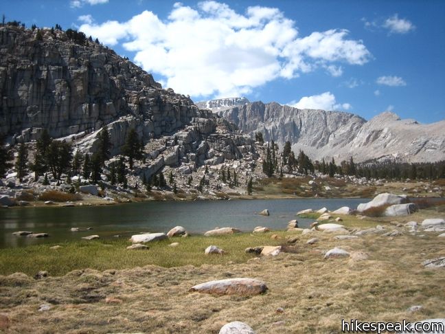
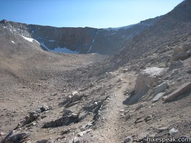
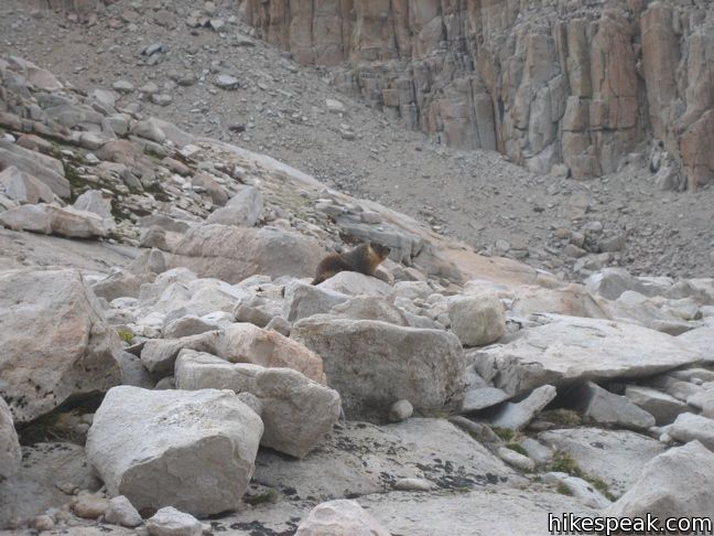
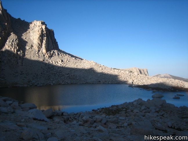
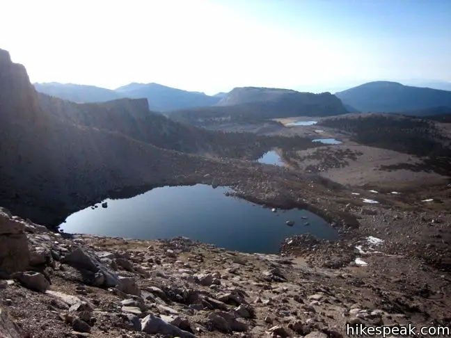
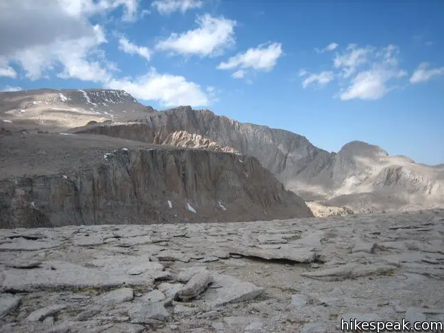
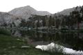
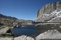
Cottonwood Lakes Trail angles uphill and reaches Cottonwood Lake Number One five miles from the trailhead. The views continue to improve as you pass meadows, creeks, and a second Cottonwood Lake. The trail rises over a crest to emerge at the end of Long Lake, a spectacular setting. The natural beauty of the mountains and lake is so powerful that many backpackers choose to camp right here.
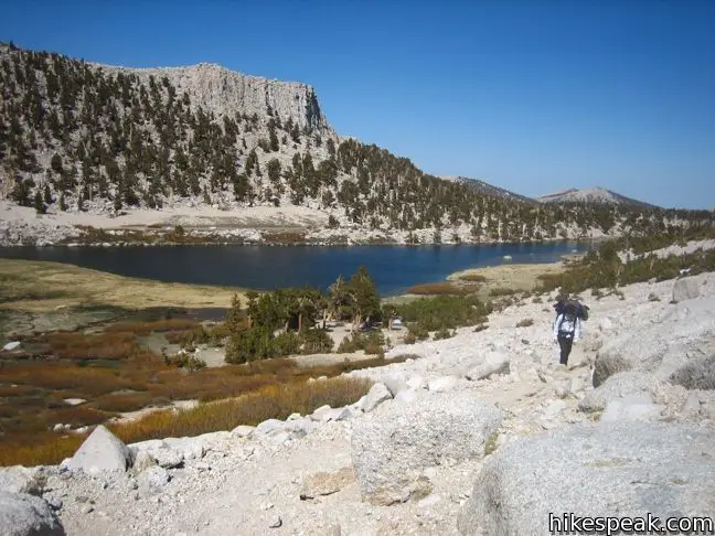
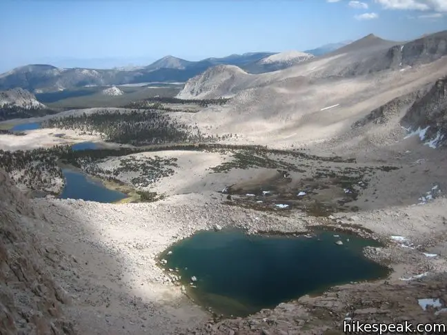
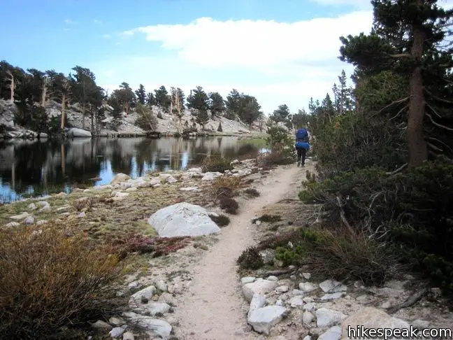
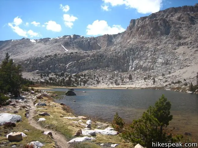
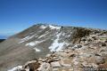
The trail to New Army Pass continues along the west shore of Long Lake and crosses a bolder-strewn ridge with nice views of Cirque Peak. Just ahead, and 6.5 miles from the trailhead, is High Lake. At 11,500 feet, this is the preferred backcountry rest point for backpackers who have their sight set on Langley. From here it is a mile to the pass and another three or four miles of off-trail traversing to the summit.
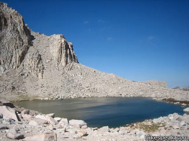
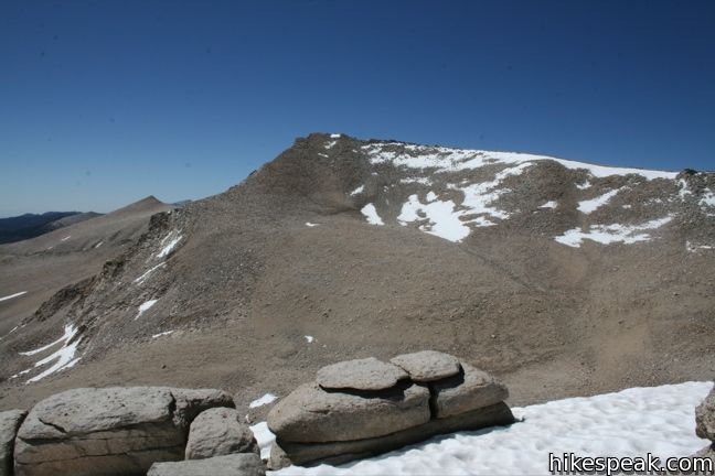
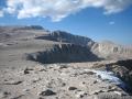
Above High Lake, the trail climbs a series of moderate switches to the 12,300-foot pass into Sequoia National Park. Unless you are here late in the summer, there will be a shelf of well-trodden snow along the pass to cross over.
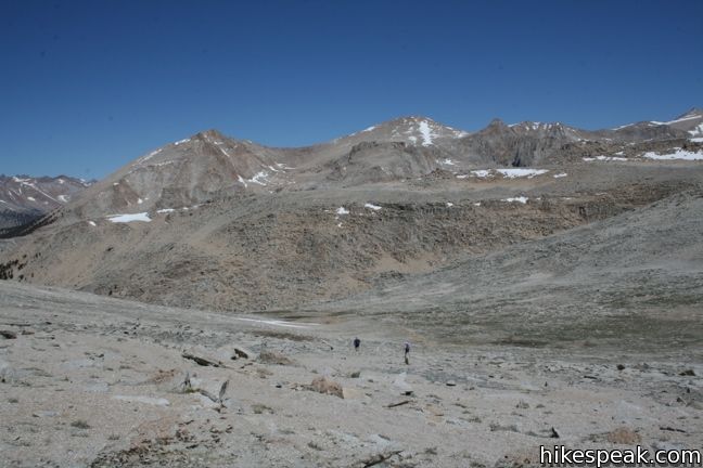
New Army Pass is 7.5 miles from the trailhead (with 2,350 feet of elevation change), but day hikers may wish to turn around before then at High Lake (6.5-miles) or Long Lake (5.75-miles). From the pass, hikers are in a great position to venture an ascent on Cirque Peak or Mount Langley (the ninth tallest mountain in California), or drop down the other side of the pass to Lower Soldier Lake, Miter Basin, and the expansive network of trails in the Sierra.
What you should know before you go: A free wilderness permit is required for all overnight trips into the national forest.
A trail quota is also in place on Cottonwood Lakes trailhead from the end of June to mid-September. A permit may be booked in advance for a five-dollar fee or obtained the day of the hike for free at the nearby ranger station in Lone Pine (or one of the other permit offices in the Inyo National Forest). The quotas are generous for Cottonwood Lakes trailhead and those who haven’t reserved a permit will most likely be able to obtain one on the day of the hike (if you get to the ranger station early in the morning). Cottonwood Lakes Trail opens to sixty permits per day. Thirty-six of those may be reserved ahead of time for a fee of five dollars and twenty-four are saved for walk-ins.
Campfires are permitted and backpackers must set up camp at least 100 feet from lake shores and streams. There are not garbage cans or bathrooms along the trail, so hike responsibly.
To be safe, backpackers must carry a bear canister to hold their food while camping. These can be rented in Lone Pine for five dollars. Bear Lockers are provided at the trailhead. Make sure your vehicle is bear-safe before leaving the parking lot.
Given the high elevation of the trailhead at Horseshoe Meadow, altitude sickness is prevalent in the region. Backpackers are well advised to spend a night of acclimation at one of the trailhead campgrounds or be prepared to face the symptoms (headaches, nausea, and lack of appetite) out on the trail. When traveling in the backcountry, you may also with to carry an SOS beacon and communicator.
Directions to the Trailhead
- It takes half an hour to ascend from the city of Lone Pine to the trailhead campgrounds.
- From Route 395 in Lone Pine, turn west at the traffic light on to Whitney Portal Road.
- After three miles, turn left on Horseshoe Meadow Road.
- Drive twenty miles up mountain switchbacks to the end of the road at Horseshoe Meadow.
- Turn right, following signs for Cottonwood Lakes and park at the trailhead.
Trailhead Location
Trailhead address: Horseshoe Meadows Road, Inyo National Forest, Lone Pine, CA 93545
Trailhead coordinates: 36.4532, -118.1699 (36° 27′ 11.5″N 118° 10′ 11.6″W)
View Eastern Sierra in a larger map
Or view a regional map of surrounding Sierra Nevada trails and campgrounds.


 | New Army Pass Trail This trail continues down the northwest side of New Army Pass into Sequoia National Park toward Lower Soldier Lake. |
 | Mount Langley This 22-mile trek travels past Cottonwood Lakes Trail over New Army Pass to a 14,042-foot summit with towering views of the Sierra. |
 | Old Cottonwood Creek Trail This 8 to 9-mile day hike follows a secluded trail through mountain meadows to the South Fork Lakes and Cirque Lake. |
 | Cirque Peak This 12,900-foot summit can be reached via off-trail ascents from New Army Pass, Cirque Lake, and Chicken Spring Lake. |
 | Cottonwood Pass This 7-mile round trip trail ascends 1,200 feet to an 11,200-foot pass and a junction with the Pacific Crest Trail, with access to Golden Trout Wilderness and Sequoia National Park. |
 | Lower Soldier Lake This 19.2-mile loop crosses Cottonwood Pass and New Army Pass to visit a beautiful lake that is an ideal camping spot for backpackers heading higher and deeper into the Sierra. |
 | Sky Blue Lake This hike extends beyond Lower Soldier Lake up Miter Basin to a deep blue lake surrounded by towering peaks. |
 | More trails in the Sierra Nevada Mountains Explore other destinations in Sequoia National Park and the rest of the range. |
 | Horseshoe Meadow Campgrounds This pair of campgrounds offer 40 sites and serve as a great base for the Cottonwood Pass and Cottonwood Lakes trails. |
- Cottonwood Lakes Trail on summitpost.org (opens in a new tab)
- Cottonwood Lakes Trail in Sequoia National Park: Your Complete Hiking Guide by Mike White (opens in a new tab)
- Cottonwood Lakes Trail in The High Sierra: Peaks, Passes, and Trails by R. J. Secor (opens in a new tab)
- Trail and campground status page for the Mount Whitney Ranger District of Inyo National Forest (opens in a new tab)
- Inyo National Forest bear canister page (opens in a new tab)
- The official website for Inyo National Forest (opens in a new tab)
Common Questions about Cottonwood Lakes Trail to New Army Pass in the John Muir Wilderness
- Is the trail open?
- Yes. You should expect to find that Cottonwood Lakes Trail is open. There are no recent reports of trail closures. If you discover that the trail is closed, please help your fellow hikers by reporting a closure.
- Is this trail free to access?
- Yes, Cottonwood Lakes Trail is free to access. No entrance fee, pass, or permit is required. If you discover that access rules have changed, please provide feedback on your experience.
- How much time does this hike take?
- It takes approximately 7 hours 45 minutes to hike Cottonwood Lakes Trail. Individual hiking times vary. Add extra time for breaks and taking in the views.
- How long is this hike?
- The hike to Cottonwood Lakes Trail is a 15 mile out and back with 2350 feet of elevation change.
- Are dogs allowed on this trail?
- Yes, dogs are allowed on Cottonwood Lakes Trail. The trail is open to hikers, dogs.
- Is Cottonwood Lakes Trail a difficult hike?
- This hike should be considered strenuous. Hikers should be prepared for a workout covering 15 miles and 2350 feet of climbing.
- Is there a lake on this hike?
- Yes, Cottonwood Lakes Trail visits a lake.
- Where is the trailhead located?
- The trailhead for Cottonwood Lakes Trail is located in Lone Pine, CA.
Trailhead Address:
Horseshoe Meadows Road
Lone Pine, CA 93545
Trailhead Coordinates:
36.4532, -118.1699 - What are the driving directions to the start of the hike?
To get to the trailhead: It takes half an hour to ascend from the city of Lone Pine to the trailhead campgrounds. From Route 395 in Lone Pine, turn west at the traffic light on to Whitney Portal Road. After three miles, turn left on Horseshoe Meadow Road. Drive twenty miles up mountain switchbacks to the end of the road at Horseshoe Meadow. Turn right, following signs for Cottonwood Lakes and park at the trailhead.
View custom Google Maps directions from your current location.
- Are there other trails near Cottonwood Lakes Trail?
- Yes, you can find other nearby hikes using the Hikespeak Hike Finder Map.

34 Comments on Cottonwood Lakes Trail to New Army Pass in the John Muir Wilderness
What hikers are saying:
✨ Generated summary of user commentsMany hikers find this area to be a demanding experience, often noting the abundance of water throughout the basin. Some visitors suggest camping near High Lake to help acclimate before attempting higher peaks. It is often recommended to prepare for sudden weather changes like rain or hail, and some travelers suggest starting early, such as 7 a.m., to manage long days on the trail.
[…] Cottonwood Lakes Trail | John Muir Wilderness | Hikespeak.com […]
How likely is it that there will be snow and ice on the summit of Mt. Langley at the end of September? Thanks for your input.
This was a low year for snow in the Sierra. Looking at the Mount Whitney webcam, there is currently no snow to be seen in the area around Mount Langley.
Planning to hike up to the summit during Christmas Time. Will the area be covered by snow all around at that time frame?
I expect it will be. Check to confirm that the road is open. Enjoy!
Planning to backpack Cottonwood Lakes Trail to New Army Pass the week of June 17th–do you know a ballpark for low temps in the area? Will there likely be snow on the trail? Rain? Thanks!
Hi Hikespeak: I noticed in your section labeled “What you should know before you go” that you mentioned campfires are permitted. However, I read a few things on the National Park Service website that fires are not permitted above 10,400 feet in Inyo. Would you mind clarifying that for me?
Your correct. campfires will only be allowed at the campsites near the trailhead. You’ll be over 10,400 feet once you get going on the trail, so campfires won’t be allowed. I’ve updated the write-up. Thanks for the catch!
my buddy and i are planning on using Cottonwood Lakes Trail to ultimately summit mt whitney. i’ve read a number of reviews/trail conditions but haven’t seen anything on mosquito activity. i’ve been to some spots in yosemite that were a nightmare when it comes to bugs. just curious what the area is like. we have permits for august 7-11.
Hi- I haven’t come across mosquitoes in the Cottonwood Lakes area, but you might run into patches of flies on your loop (I encountered a swarm at the bottom of Miter Basin that was completely fierce). Enjoy your journey. Cottonwood Lakes to Mt. Whitney is on my to-do list!
We are going up to camp and hike to Langley in mid-August as well. Any word on the water situation in the various lakes, especially around the Rock Creek area – Lower Soldier Lake, Erin Lake, Primrose Lake, etc? Appreciate any input.
hey Chris,
my brother and i are planning that same trip, plan to hike from 11 to 15 august hitting langley muir and whitney, nice to see others are doing the same.
awesome, our goal is to finish in 3 days. if we get back on the 10th i’ll update you with conditions.
My friend and I are planning a 2 day hike 6/30 to the Cottonwoods Lake area, can you tell us if there is water in the lakes and or how low the level is. Also what kind of high and low temps should we expect?
Ryan we made it back last night. Not sure where you’re planning on setting up base camp. Here is what our itinerary consisted of:
day 1 – enter from cottonwood trail head. hike 9.5 hours & camp at sky blue lake. crabtree pass is steep and covered with scree. I would not recommend attempting to pass this feature with a 4 day pack unless you are prepared.
day 2 – leave for whitney. we left sky blue lake at 7 am and made it back to camp after dark around 8:30 pm. last light at sky blue lake is around 7:45 pm; hike almost 13 hours.
day 3 – hike out back to cottonwood trail head; hike 9 hours.
no bugs, water everywhere. once you get past soldier lake, you don’t see anyone. we had sky blue lake to ourselves both nights. we got hit by hail coming back from whitney over crabtree pass as well as hiked back to blue sky lake in a lightning storm….there’s no real trail once your past soldier lake. it’s very demanding. good luck and be safe.
When is the trail open? Is it too cold do in March or April?
Why are campfires not permitted above 10,400 feet?
Looking at Mt Whitney webcam there appears to be minimal snow in the area. Does anyone know the snowpack conditions as of end of May 2015 on the Normal Route Army Pass to Mt. Langley?
I returned today from completing a 3 day trip to cottonwood lake basin. Although winter brought little snow, we had rain, hail and snow during each evening and all creeks were rushing. Today it rained the entire hike out. Prepare for all types of weather
I was wondering if I can take my dogs, 2 small terriers who love to go with me.
Dogs are allowed as long as they are leashed and you stick to the national forest and don’t go into Sequoia National Park. However, there are many reasons not to bring pets into the wilderness. These website have more info about pet rules in Inyo National Forest and John Muir Wilderness.
I made the summit of Langley with my friend and his best friend….his dog.
My son and I hope to complete the JMT this July. If we can’t get a permit to exit via Whitney Portal I plan on exiting via the Cottonwood Pass or the Cottonwood Lake trail. If we were picking a trail for the fastest exit, which would be better and what are the distances for each from Whitney to the trail heads.
[…] started the day towards New Army Pass (note, you can also take Cottonwood Pass – both will get you to the same place). The camping […]
What is the condition of the road going up there? I was last there in 1973 and it was mostly paved.
Thanks. George Bartkowski
The trail is paved all the way and in good shape. You should go back!
Any recent reports on New Army Pass conditions?
Thanks!
What is the best way to break up the hike to Mt. Langley and back from the Cottonwood Lakes trailhead? I want one night to acclimate, but I also don’t want to do 20 miles in one day so I don’t want to camp at the trailhead. Is it best to camp at one of the lakes? Thanks!
Hi,
I would (and did) stop to camp before the ascent to New Army Pass. Consider camping around High Lake, the last lake along the trail.
We are planning a 3 night trip to the Cottonwood Lakes area August 15-17. Our bucket list includes catching a golden trout. Should we go to all 5 lakes? We would like to keep a few for dinner maybe, is 3 nights enough? Never been to area before. Thanks for any Info.
Hi. I did Whitney last year with some friends. Great hike. I’m familiar with the permit requirements, etc. for that hike. My questions is related to Langley. I’ve been told no permits are required at all for day use, and that Horseshoe camping is walk-in and does not require permits ahead of time. Our plan is to drive to Horseshoe and camp one night, and then roundtrip Langley the next day. So my question is, do we need to obtain any permits at all for this? Do we need a permit to camp overnight? Do we need to get one of the plentiful day permits that are available in stacks at ranger stations (not lottery based)? Or do we need to show-up in Lone Pine and try for an official lottery day-pass the day before like you would for Whitney?
Unless the rules have changed… you should not need a permit to hike up Langley all in one day (only for backpacking trips). No permit for the car camping either. Have a great trip!
The cost to camp at the walk-in site near the trailhead is $6 per tent space. Payment is made via an envelope at information board. No permit is need to day hike.
hello, I am thinking of hiking to Cottonwood lakes this weekend (9-11-2016).
Will I have issues with snow? Will I be the only one up there?
thanks in advance