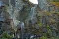
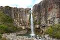
Mangawhero Falls
in Tongariro National Park
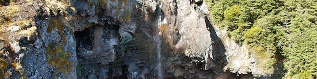
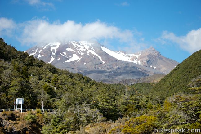
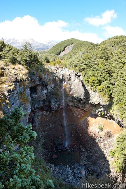
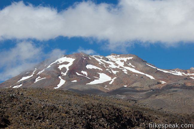
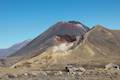
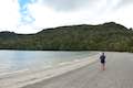
Tongariro National Park has many wonders. Some are impossible to miss, like massive volcanoes, and other, like beautiful waterfalls, are waiting to be discovered. Mangawhero Falls plunges 25 meters (80 feet) in a beautiful setting. The waterfall is below Mount Ruapehu, New Zealand’s largest volcano and the highest peak on the North Island. Reach the waterfall on an easy 300-meter round trip walk that will only take about 10 minutes.
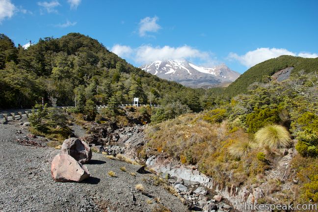
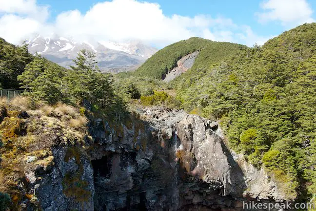
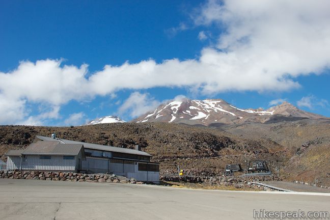
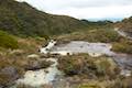
Start from a turnout along Ohakune Mountain Road, about 15 kilometers north of the town of Ohakune on the south side of Tongariro National Park. This very short track heads south down the right side of a tumbling stream, Mangawhero River. The water’s superb source, Mount Ruapehu, can be seen upstream.
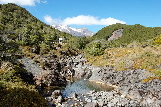
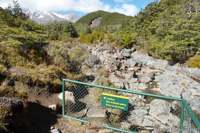
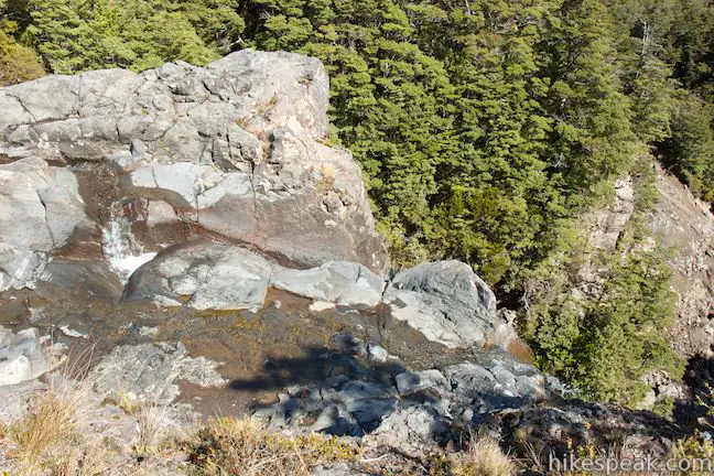
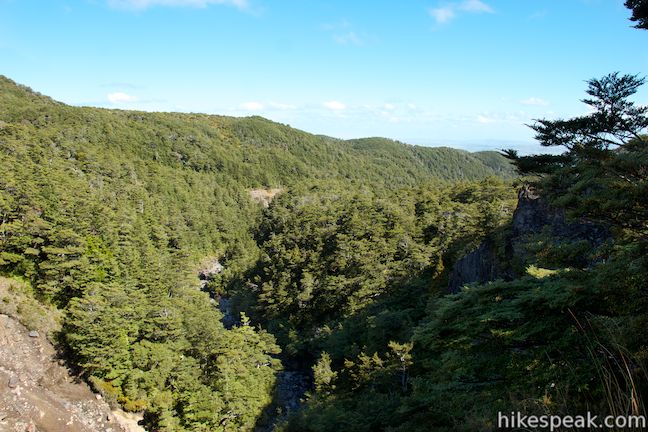
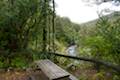
The walking track quickly reaches an overlook at the brink of the falls. The water disappears, dropping off a cliff into the canyon below. To really see the waterfall, continue down the path along the edge of the cliffs above the river. Soon you will arrive at an overlook where the path ends. Stand behind the railing and enjoy a full view of Mangawhero Falls.
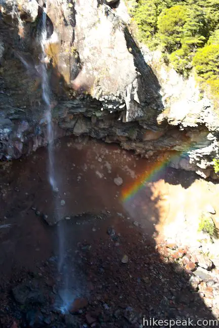
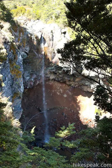
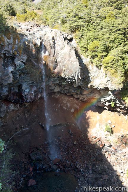
The single-drop waterfall leaps from a cliff of volcanic rock and falls into a pool. When the river isn’t at full strength, wind can catch the sinewy waterfall and blow it out from the rock face. Mount Ruapehu rises up above Mangawhero Falls, allowing you to get an impressive photo of the tall waterfall and the glacier-covered mountain behind. If you’re lucky, a rainbow may even appear along the waterfall to further enhance the scenery.
No route goes down to the pool at the base of the falls (although The Lord of the Rings did use this section of the river as a filming location), so simply return to the car park once you’ve taken in the waterfall from the viewpoint. A visit to Mangawhero Falls delivers lots of natural beauty in a short walk.
Dogs and bikes are not allowed. No fee or permit is required to visit Mangawhero Falls, so get out and enjoy! To see Tongariro National Park‘s biggest waterfall, check out nearby Waitonga Falls.
Directions to the Trailhead
- Take State Highway 49 to the center of Ohakune and turn north up Goldfinch Street, which is directly across from the i-SITE.
- Drive 1.1 kilometers and continue onto Mangawhero Terrace.
- After 1.2 kilometers, cross Old Station Road, pass under railroad tracks, and continue north up Ohakune Mountain Road.
- It is 13 kilometers up this road to the track to Mangawhero Falls, beginning from a large gravel turnout on the right.
- For an even closer look at Mount Ruapehu, drive another 3 kilometers up to the chairlifts at road's end.
Trailhead Location
Trailhead address: Ohakune Mountain Road, Tongariro National Park, Manawatu-Wanganui, 4691, New Zealand
Trailhead coordinates: -39.319218, 175.502732 (39° 19′ 09.18″S 175° 30′ 09.83″E)
You may also view a regional map of surrounding New Zealand tracks, campgrounds, and lodging.


 | Waitonga Falls This 4-kilometer return hike reaches Tongariro National Park's tallest waterfall and passes through an alpine wetland that reflect views of Mount Ruapehu. |
 | Rimu Walk This short, level walk explores a Rimu forest along the Mangawhero River near the town of Ohakune at the south end of Tongariro National Park. |
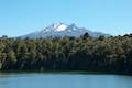 | Lake Rotokura This 2-kilometer return hike reaches a peaceful blue lake that reflects a view of Mount Ruapehu, the tallest mountain in the North Island. |
 | Silica Rapids This 5.15-kilometer point-to-point hike or 7.15 kilometer loop leaves from Whakapapa Village in Tongariro National Park and crosses alpine bogs, forests, streams, and ridges of volcanic rock to reach creamy cascades on silica terraces. |
 | Taranaki Falls This 6.45-kilometer loop crosses a variety of volcano-influenced landscapes to reach a beautiful 20-meter tall waterfall in Tongariro National Park. |
 | Tawhai Falls This 0.8-kilometer return hike visits a short but enticing single-drop waterfall near Whakapapa Village in Tongariro National Park. |
 | Tongariro Alpine Crossing This 19.4-kilometer long through-hike ventures across dynamic volcanic landscapes in Tongariro National Park and ranks among the world's greatest day hikes. |
 | Lake Rotopounamu This 6.4-kilometer loop visits tranquil beaches on a forest-wrapped lake in Tongariro National Park. |
 | More trails in New Zealand Explore other destinations for walking and hiking (as well camping and lodging) in New Zealand. |
 | Mangawhero Campground This campground in Tongariro National Park near Ohakuna, New Zealand has twelves sites on two loops with views of Mount Ruapehu. |
 | Whakapapa Holiday Park This holiday park in Whakapapa Village offers tent sites, campervan sites, cabins, and a backpackers lodge along a stream below Mount Ruapehu in Tongariro National Park. |
- Mangawhero Falls on world-of-waterfalls.com (opens in a new tab)
- Mangawhero Waterfall Walking Hiking on visitruapehu.com (opens in a new tab)
- Mangawhero Falls on jonnymelon.com (opens in a new tab)
- Mangawhero Falls on waterfalls.co.nz (opens in a new tab)
- The Department of Conservation webpage for Ohakune Area Short Walks (including Mangawhero Falls) (opens in a new tab)
Common Questions about Mangawhero Falls in Tongariro National Park
- Is the trail open?
- Yes. You should expect to find that Mangawhero Falls Track is open. There are no recent reports of trail closures. If you discover that the trail is closed, please help your fellow hikers by reporting a closure.
- Is this trail free to access?
- Yes, Mangawhero Falls Track is free to access. No entrance fee, pass, or permit is required. If you discover that access rules have changed, please provide feedback on your experience.
- How long is this hike?
- The hike to Mangawhero Falls Track is a 0.3 km / 0.2 mile out and back return with 10 meters / 30 feet of elevation change.
- Are dogs allowed on this trail?
- No, dogs are likely not allowed on Mangawhero Falls Track. The trail is primarily open to hikers.
- Is Mangawhero Falls Track good for kids?
- Yes, this hike is likely suitable for children. It is relatively short (0.2 miles) with manageable elevation gain.
- Will I see a waterfall on this hike?
- Yes, Mangawhero Falls Track features a waterfall.
- Where is the trailhead located?
- The trailhead for Mangawhero Falls Track is located in Tongariro National Park, Manawatu-Wanganui.
Trailhead Address:
Ohakune Mountain Road
Tongariro National Park, Manawatu-Wanganui 4691
Trailhead Coordinates:
–39.319218, 175.502732 - What are the driving directions to the start of the hike?
To get to the trailhead: Take State Highway 49 to the center of Ohakune and turn north up Goldfinch Street, which is directly across from the i-SITE. Drive 1.1 kilometers and continue onto Mangawhero Terrace. After 1.2 kilometers, cross Old Station Road, pass under railroad tracks, and continue north up Ohakune Mountain Road. It is 13 kilometers up this road to the track to Mangawhero Falls, beginning from a large gravel turnout on the right. For an even closer look at Mount Ruapehu, drive another 3 kilometers up to the chairlifts at road's end.
View custom Google Maps directions from your current location.
- Are there other trails near Mangawhero Falls Track?
- Yes, you can find other nearby hikes using the Hikespeak Hike Finder Map.

Go the extra miles...
Submit a rating of this hike to go with your comment. Contribute to the average trail rating.