The High Peaks of Pinnacles National Park (formerly known as Pinnacles National Monument) are a one-of-a-kind collection of sky-pointed spires that provide fascinating scenery and a robust hiking experience. The adventurous hike across the top of the Pinnacles crosses a steep, narrow, and impressively constructed trail that is a highlight of any visit to the park.
The High Peaks can be reached from the east or west entrance. No roads travel across Pinnacles National Park, so the heart of the rugged park is only accessible on foot via a well-maintained network of trails. An excellent option that begins on the east side of the park and travels up High Peaks Trail, across the Pinnacles, and down Condor Gulch Trail makes a 5.3 or 6-mile hike. The total distance depends on whether or not you include a visit to Bear Gulch Reservoir (and you probably should). Between the top and bottom of the trail are 1,325 feet of elevation change and panoramic views.
A few alternative routes incorporate the High Peaks, including the longer High Peaks – Balconies Cave Loop.
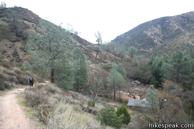
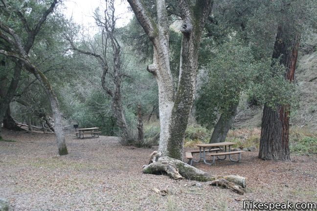
Begin at the Bear Gulch Day Use Area and hike south toward Bear Gulch Reservoir. If you are skipping the reservoir, the directions are simple. Make a right at every junction you come to heading clockwise around the loop.
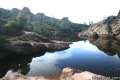
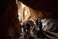
To visit the reservoir, turn left at the junction 0.2 miles from the start and hike just over half a mile to the reservoir. There is an option along the way to hike up Moses Spring Trail or Bear Gulch Cave Trail. Both are worthwhile, but the Cave Trail should not be missed if it is open. From the reservoir, turn north up Rim Trail, which provides nice views as it backtracks above Bear Gulch for 0.4 miles to a junction with High Peaks Trail. Turn left here, joining the single track coming up from the first trail junction, 0.3 miles below.
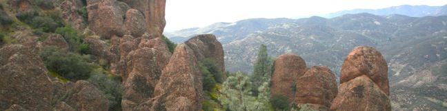
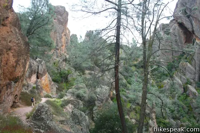
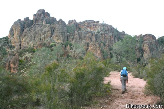
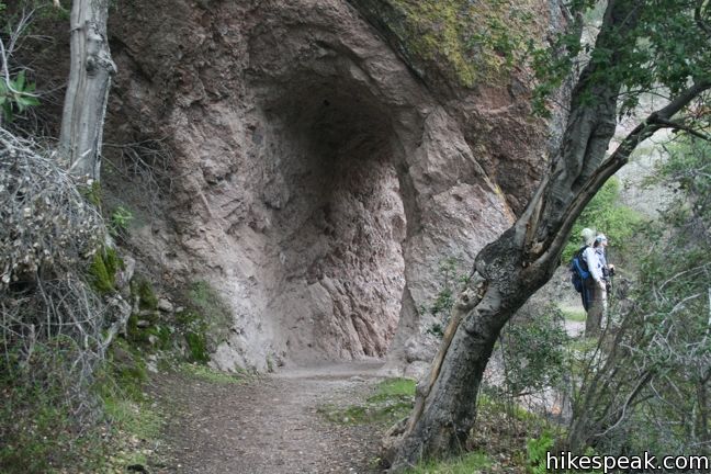
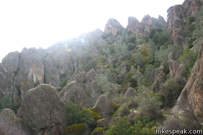
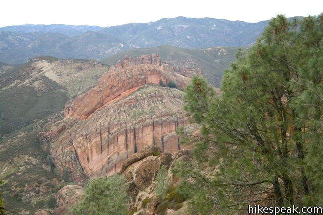
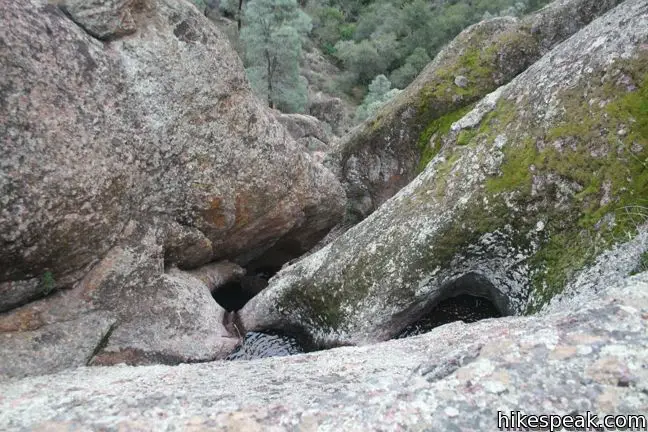
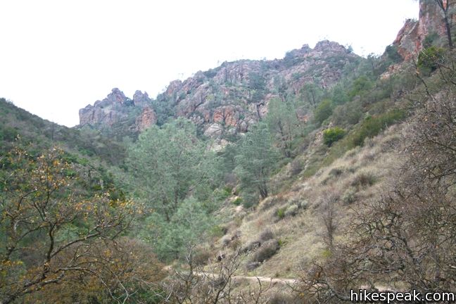
Above the Rim Trail junction, High Peaks Trail offers a more arduous climb, tackling 850 feet over 1.5 miles to a lofty junction near Scout Peak. Take your time tackling the elevation and enjoy the widening views. The trail enters a world of tall strangely shaped monoliths that thrust out of the landscape like nothing else around. Pass through a tunnel carved in the rock and continue another half mile up switchbacks to the junction near Scout Peak. There is a bathroom at the junction, which is located at the south end of the notorious section of High Peaks Trail that crosses the backbone of the Pinnacles.
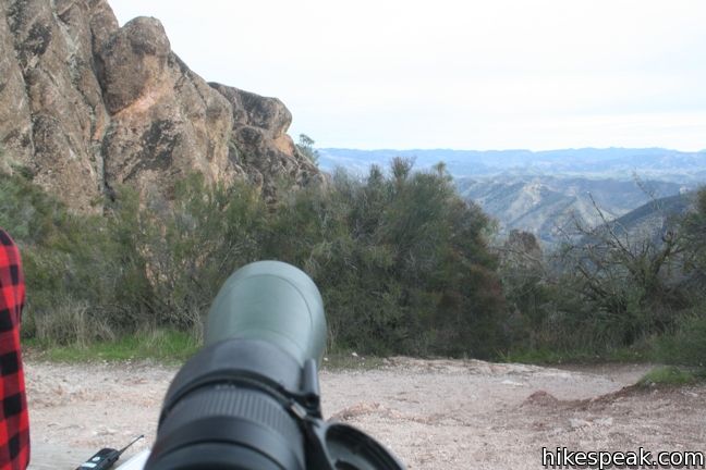
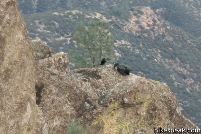
You may have the good fortune to meet a telescope-bearing volunteer stationed here tracking California condors. These massive birds were near extinction before being rescued and reintroduced by a captive breeding program. Pinnacles National Park (then Pinnacles National Monument) was a primary release point for the condor, and the immense birds have reestablished themselves here. California condors weigh about 20 pounds and have a wingspan of 9½ feet. Park staffers and volunteers continue to monitor the progress of these daunting creatures, and it is important to be respectful of the birds if you are lucky enough to see one. The gargantuan birds are not always easy to spot, but High Peaks Trail is a great place to look.
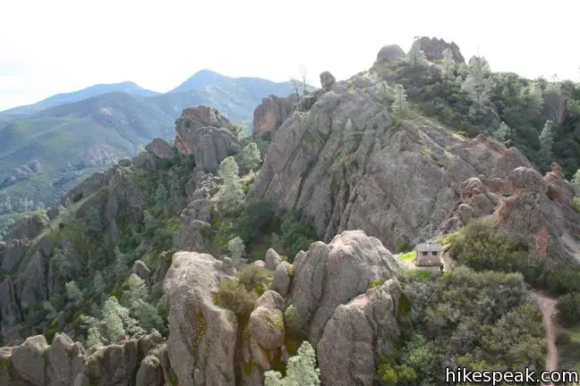
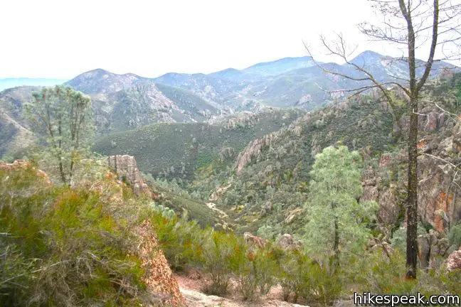
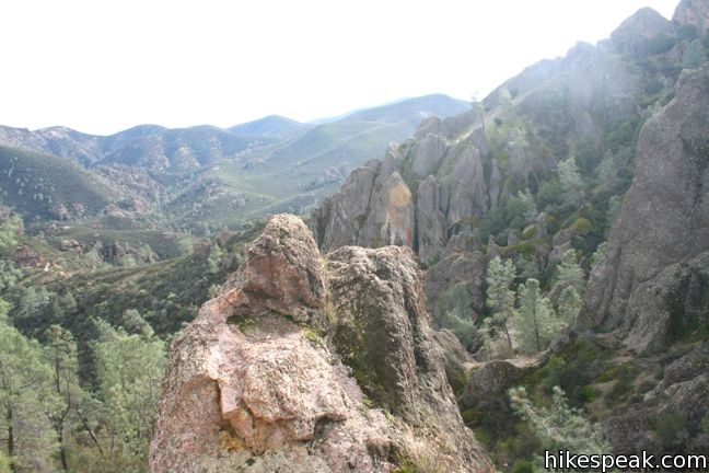
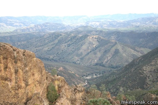
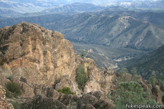
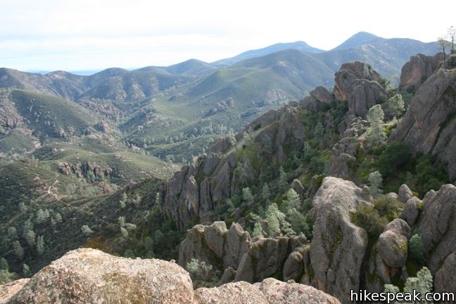
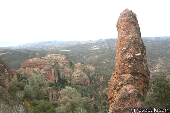
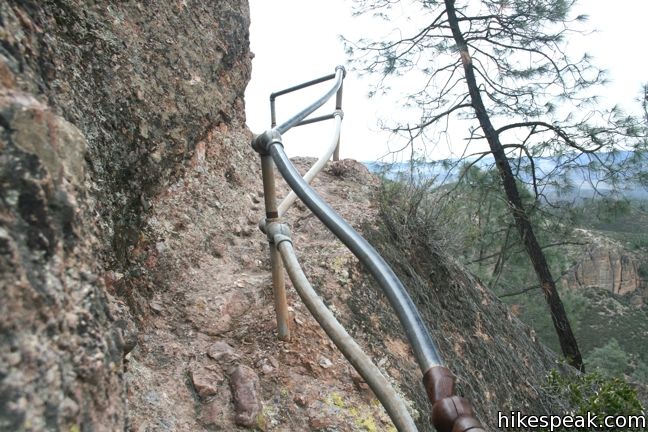
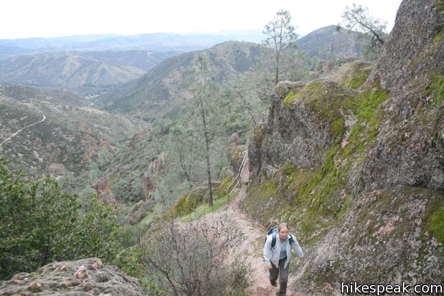
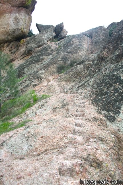
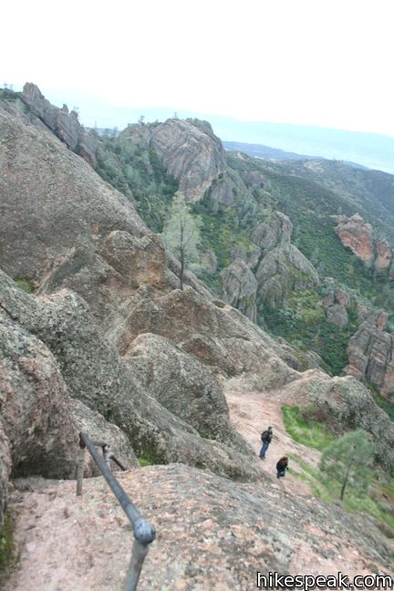
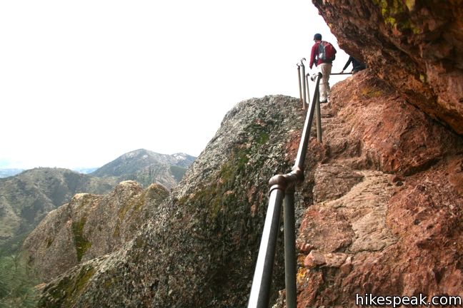
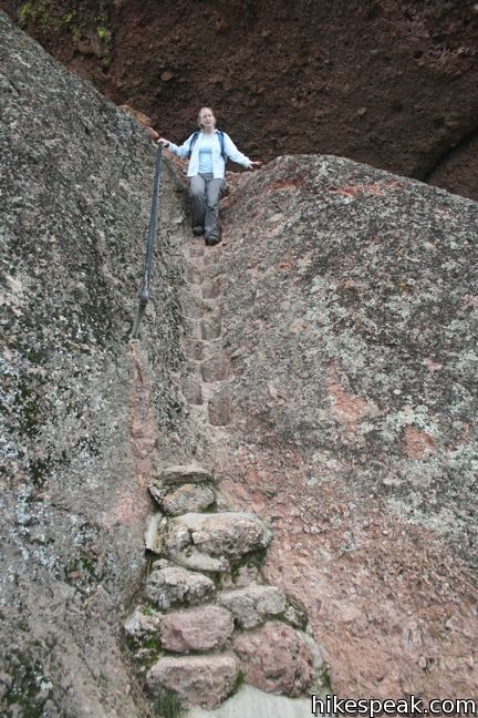
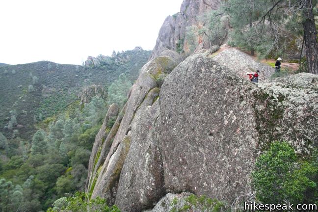
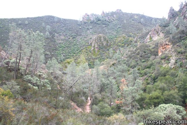
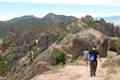
Turn right at the Scout Peak junction and head north across the peaks. The trail is steep and narrow in many areas over the next 1.3 miles, ascending to a height of 2,570 feet. Building this trail must have been quite an endeavor. There are steps carved into the rock and occasional railings to make the crossing possible. The scenery is incredible. This cluster of peaks is the tallest thing around, and the views are vast.

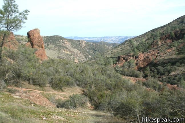
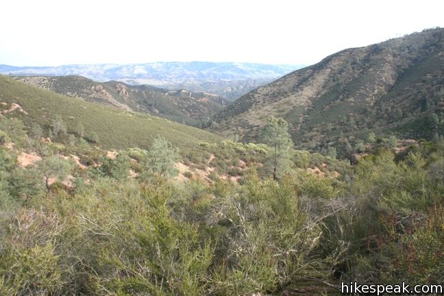
Stay to the right through a junction with Tunnel Trail and continue northeast across the wild peaks to a junction with Condor Gulch Trail. Turn right, leaving the amazing trail to begin the descent to the Bear Gulch Day Use Area. The gradual trail features southeasterly views, exiting the rocky pinnacles for chaparral-covered slopes. Condor Gulch Trail is 1.7 miles long from top to bottom with 1,065 feet of elevation loss.

After dropping into the gulch, there is a short turnoff on the right leading to an overlook. Take a moment to peer off the steep ledge before continuing the last mile down the gulch to the trailhead. There are bathrooms at the end of the trail for those in need of relief, and Bear Gulch Nature Center is just across the road. Turn right and hike the final quarter mile passing through a picnic area up to the parking lot where the hike began.
High Peak – Condor Gulch Loop is an excellent way to experience Pinnacles National Park. The 5.3 to 6-mile hike brings you up and over amazing rock formations with beautiful views. There is a fee to enter the park. Dogs and bicycles are not allowed on trail. Hikes will love it though, so get out and enjoy!
No permit is required to hike High Peak – Condor Gulch Loop. There is an entrance fee for Pinnacles National Park ($20 as of 2017). National Park Service passes may be used in place of the fee to gain entry. Dogs and bikes are prohibited on this loop.
Check the park’s cave status page to confirm that Bear Gulch Cave, is open before you set out. The cave closes at scheduled intervals to protect a colony of Townsend’s big-eared bats that live in the cave. If Bear Gulch Cave is open during your visit, it is definitely worth checking out. If Bear Gulch Cave is closed and Balconies Cave is open, consider hiking High Peaks — Balconies Cave Loop instead.
Directions to the Trailhead
- Take Highway 101 north to King City and exit onto First Street (exit 281).
- Turn right at the end of the ramp, heading north on First Street for 1.3 miles.
- The road makes a sharp right turn and becomes Lyons Street/Country Road G13.
- Take G13 out of the city, northeast for 14.3 to a T-junction with Route 25.
- Turn left and drive 14.2 miles to an intersection with Route 146.
- Turn left onto Route 146, following signs for Pinnacles National Park.
- Drive west into the park, passing the general store and campground on the left to reach the East Entrance Station after 2.5 miles.
- Pay the entry and proceed another 1.3 miles to the only real intersection on the park road.
- Make a left and drive south for another 1.4 miles to the Bear Gulch Day Use Area at road's end.
Trailhead Location
Trailhead address: Pinnacles National Park, Paicines, CA 95043
Trailhead coordinates: 36.4785, -121.1838 (36° 28′ 42.6″N 121° 11′ 02″W)
View Pinnacles National Park in a larger map
Or view a regional map of surrounding Central Coast trails and campgrounds.


 | Bear Gulch Reservoir This 1.5-mile hike passes through a talus cave to reach a reservoir on the east side of Pinnacles National Park. |
 | High Peaks - Balconies Cave Loop This extensive 9-mile loop ventures between the east and west sides of Pinnacles National Park, crossing through the High Peaks and Balconies Cave. |
 | Balconies Cave This 2 to 2.4-mile hike venture down Balconies Trail past impressive rock formations and through a fun talus cave, starting from Chaparral Trailhead on the west side of Pinnacles National Park. |
 | More Central Coast Hikes Explore other destinations along the California coast between Ventura and Monterey, including trails in Los Padres National Forest. |
 | Pinnacles Campground Pinnacles National Park has one campground with tent, RV, and group sites in an oak woodland on the east side of the park. |
Common Questions about High Peaks – Condor Gulch Loop in Pinnacles National Park
- Is the trail open?
- Yes. You should expect to find that High Peaks — Condor Gulch Loop is open. There are no recent reports of trail closures. If you discover that the trail is closed, please help your fellow hikers by reporting a closure.
- Do I need a permit for this hike?
- Yes. National Park Entrance Fee.
- How much time does this hike take?
- It takes approximately 3 hours 15 minutes to hike High Peaks — Condor Gulch Loop. Individual hiking times vary. Add extra time for breaks and taking in the views.
- How long is this hike?
- The hike to High Peaks — Condor Gulch Loop is a 6 mile loop with 1325 feet of elevation change.
- Are dogs allowed on this trail?
- No, dogs are likely not allowed on High Peaks — Condor Gulch Loop. The trail is primarily open to hikers.
- Does this trail go to a summit?
- Yes, High Peaks — Condor Gulch Loop reaches a summit with panoramic views.
- Where is the trailhead located?
- The trailhead for High Peaks — Condor Gulch Loop is located in Pinnacles National Park, CA.
Trailhead Address:
Pinnacles National Park
Pinnacles National Park, CA 95043
Trailhead Coordinates:
36.4785, -121.1838 - What are the driving directions to the start of the hike?
To get to the trailhead: Take Highway 101 north to King City and exit onto First Street (exit 281). Turn right at the end of the ramp, heading north on First Street for 1.3 miles. The road makes a sharp right turn and becomes Lyons Street/Country Road G13. Take G13 out of the city, northeast for 14.3 to a T-junction with Route 25. Turn left and drive 14.2 miles to an intersection with Route 146. Turn left onto Route 146, following signs for Pinnacles National Park. Drive west into the park, passing the general store and campground on the left to reach the East Entrance Station after 2.5 miles. Pay the entry and proceed another 1.3 miles to the only real intersection on the park road. Make a left and drive south for another 1.4 miles to the Bear Gulch Day Use Area at road's end.
View custom Google Maps directions from your current location.
- Are there other trails near High Peaks — Condor Gulch Loop?
- Yes, you can find other nearby hikes using the Hikespeak Hike Finder Map.

8 Comments on High Peaks – Condor Gulch Loop in Pinnacles National Park
What hikers are saying:
✨ Generated summary of user commentsHikers find this trek through Pinnacles exciting and spectacular, especially when the weather clears after a storm. Steve recommends starting before early enjoy the caves and reservoir in solitude before crowds arrive. Ascending via the Condor Gulch trail provides superior views compared to other routes.
“Couldn't have asked for a finer day or hike at Pinnacles.” Jump to comment ↓
“It's been 40 years since I last did High Peaks in my early 20s and it was just as exciting today.” Jump to comment ↓
I’d like to say thanks a million times over for the detailed trail descriptions and PICTURES. I’m pulling together a quick overnighter this weekend and while frantically looking for trails I found this, which is a godsend. All the others I’ve found are totally lacking in photos and make selecting the right trails shots in the dark. But that’s not what impressed me entirely, the description and abundant information is wonderful. I’ll be taking the two that are posted. Thanks again!
I appreciate the kind words. Enjoy your hike!
You’re a badass. On my way to do this hike right now.
Just hiked this yesterday but went up Condor Gulch trail and down High Peaks, had done High Peaks trail up last trip. We felt yesterday’s direction gave us better views as trip up Condor quite a bit more spectacular than trip up High Peaks.
GPS said 5.77 including Rim Trail to Reservior on way back.
Either way fantastic.
My wife and I hiked the reservoir loop / Rim Trail / High Peaks Trail / Condor Gulch Trail today. We went today spur of the moment because yesterday was a great storm and today the skies cleared somewhat. There were huge threatening white cumulus,clouds against a deep blue sky. Couldn’t have asked for a finer day or hike at Pinnacles. We started hiking about 9:20 AM, before the big Sunday crowds arrived, so we had the trail, caves, and reservoir pretty much to ourselves. It’s been 40 years since I last did High Peaks in my early 20s and it was just as exciting today. Thanks for the great write-up and details. They were very helpful.
[…] day (yay free National Park days!). That time, we had entered through the East entrance to hike the High Peaks trail which was absolutely gorgeous, and I highly recommend. Below is a slide show of when we hiked the […]
Thank you for the great write-up! Very useful for planning a hike…
As always, THANK YOU Hikespeak — because without you I wouldn’t have been able to embark on this trail, which I’d love for you to check out my journey on too, here! https://metropolitanmolly.com/2021/02/19/7-under-the-radar-national-parks-to-explore-in-california/