Lizard’s Mouth
in Los Padres National Forest
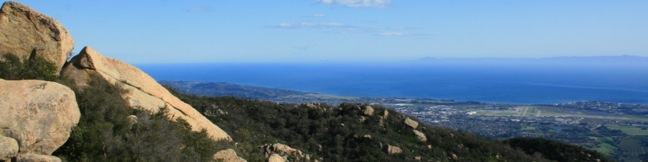
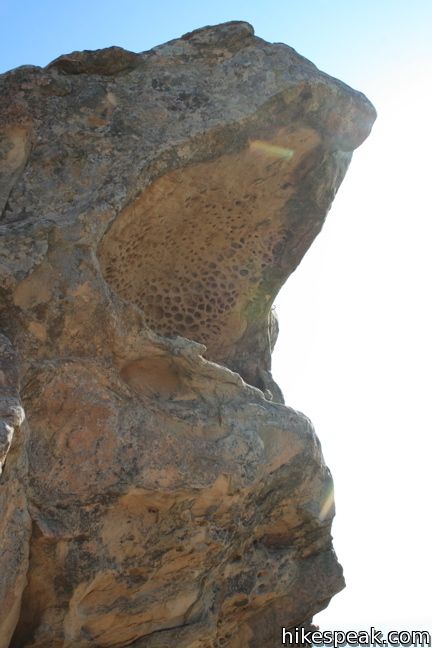
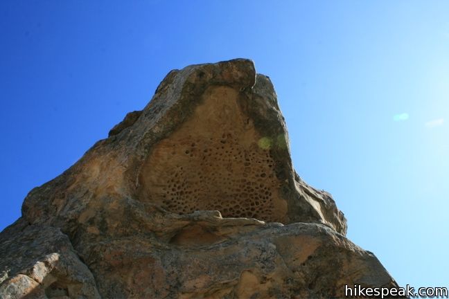
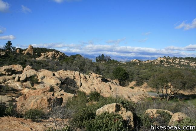
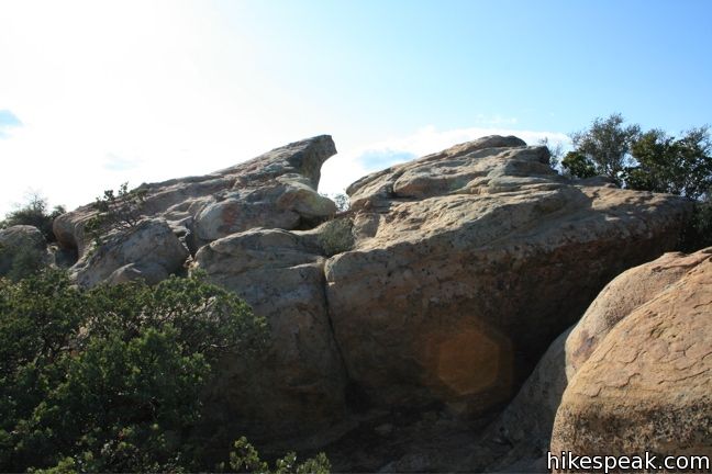
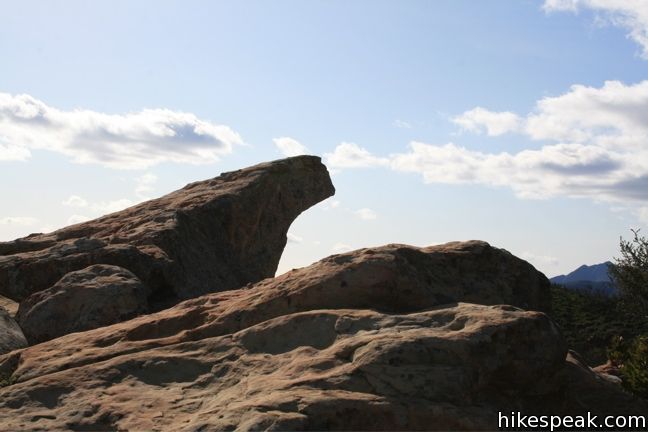
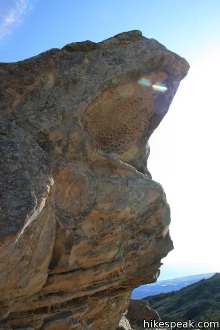
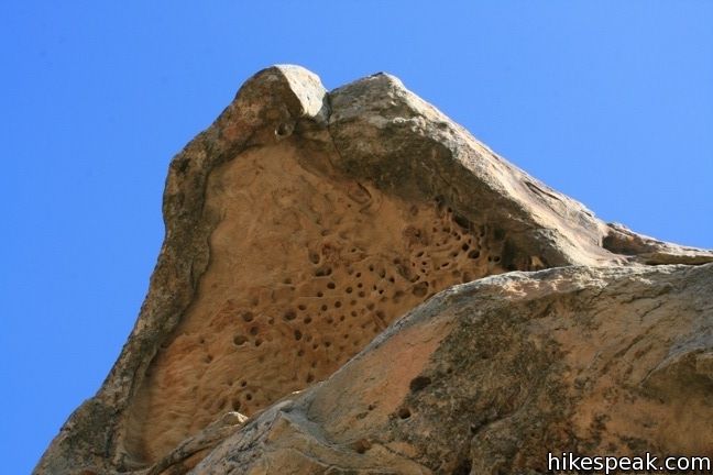
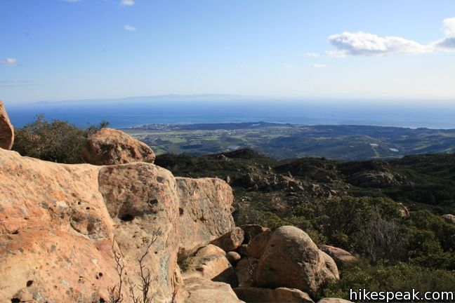
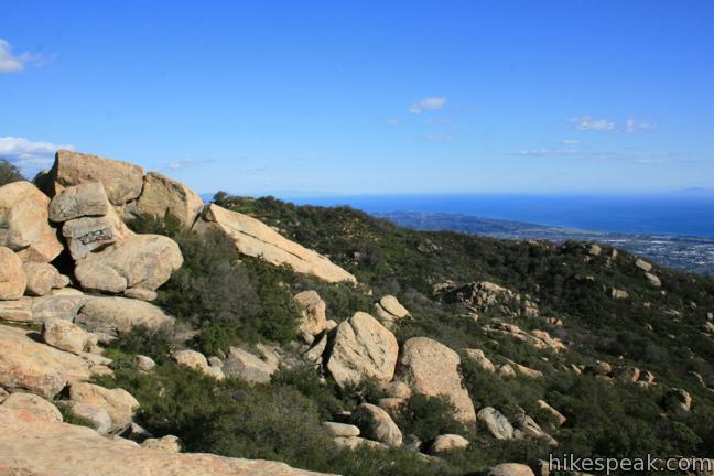
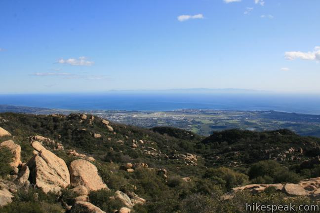
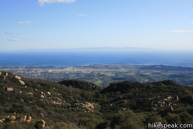
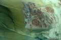
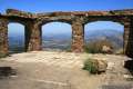
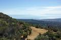
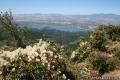
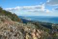
Lizard’s Mouth is a mountain top rock formation overlooking Santa Barbara. Wind-carved pockets on the underside of this sandstone outcropping give the rock a resemblance to a frog or lizard’s mouth. The short hike to Lizard’s Mouth offers sensational views and is a quick excursion for anyone traveling the 154 between Santa Barbara and Lake Cachuma or Los Olivos.
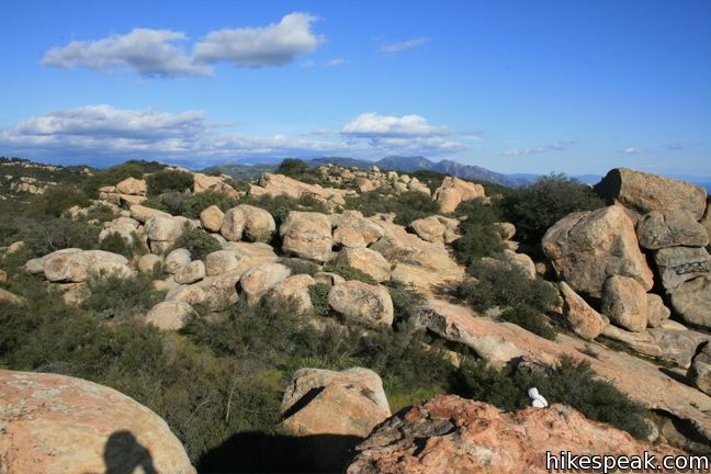
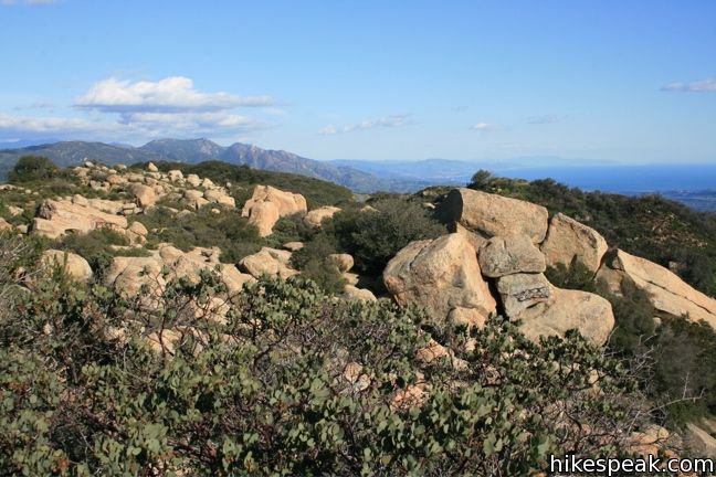
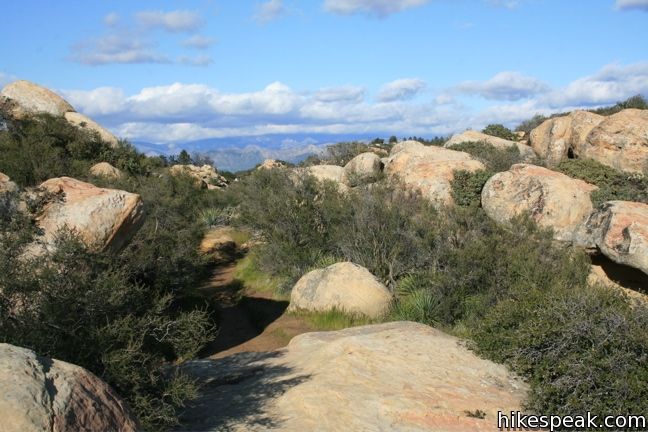
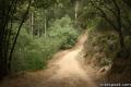
A path from West Camino Cielo meanders through boulders and brush, heading slightly uphill to a clear spot overlooking Santa Barbara. Although there are a few overlapping paths, they all lead to the same place. Turn right and ascend the slope of sandstone that forms the lizard’s back. When the side of Lizard’s Mouth becomes visible, either climb over the rocks to get to it, or continue along the path as it swings around to the destination.
An opening beneath the overhang makes for a good turnaround point. Climb up on the “lizard” and take in the panoramic views. The route back to the trailhead is the same and a bit easier to follow in reverse.
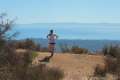
Lizard’s mouth offers a half-mile stroll with optional rock scrambling and obligatory views of Santa Barbara and the Pacific Ocean. The trail runs adjacent to the Winchester Canyon Gun Club so be prepared to hear gunfire as you hike, especially on weekends. No fee or permit is required, so get out and enjoy.
Directions to the Trailhead
- From Highway 101 west of downtown Santa Barbara, exit on Highway 154 and head north into the Santa Ynez Mountains.
- After 7 miles, turn left onto West Camino Cielo (if you reach the East Camino Cielo or the top of the mountain pass, you have gone to far).
- Off Highway 154, West Camino Cielo makes an immediate right before winding up to the top of the ridge.
- Take this road for 3.5 miles and enjoy the views over Santa Barbara.
- The trailhead is on the left side of the road a few hundred feet before the Winchester Canyon Gun Club.
- When you reach the gun club or the point where the road becomes unpaved, turn around and backtrack to the roadside parking near the trailhead.
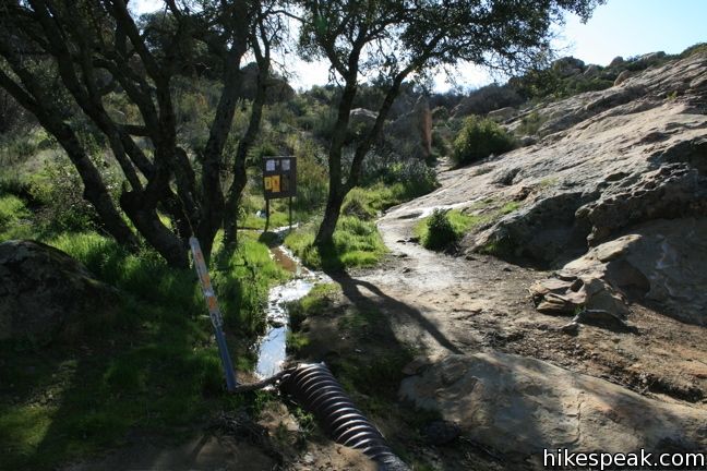
- A wooden board next to a tree (and a brown pipe on the ground) mark the start of the trail to Lizard's Mouth.
Trailhead Location
Trailhead address: West Camino Cielo (Forest Route 5N12), Los Padres National Forest, Santa Barbara, CA 93105
Trailhead coordinates: 34.503055, -119.86569 (34° 30′ 10.99″N 119° 51′ 56.48″W)
View Santa Ynez Mountains in a larger map
Or view a regional map of surrounding Central Coast trails and campgrounds.


 | Chumash Painted Cave This very short trail looks in on Native American rock art in the Santa Ynez Mountains. |
 | Knapp's Castle This easy 0.8-mile hike visits the scenic ruins of an estate home built atop the mountains behind Santa Barbara. |
 | Inspiration Point from San Roque Road This 7.55 to 7.95-mile round trip hike ascends 1,400 feet up the western side of Jesusita Trail to a panoramic perch in the Santa Ynez Mountains with great views over Santa Barbara. |
 | Inspiration Point from Tunnel Road This 3.75-mile round trip combines Tunnel Trail and Jesusita Trail to ascend Mission Canyon to a sweeping viewpoint that looks down over Santa Barbara and up into the Santa Ynez Mountains. |
 | Tequepis Trail This invigorating 8.4-mile round trip hike offers views of Lake Cachuma as it climbs the Santa Ynez mountains to views of Santa Barbara and the Pacific. |
 | Nojoqui Falls This short 0.65-mile hike visits an 80-foot tall fern-lined waterfall. |
 | Gaviota Peak This 6.5-mile loop mounts a 2,458-foot summit two miles from the Pacific and then descends Trespass Trail to explore the wilds of the Santa Ynez Mountains. |
 | Gaviota Wind Caves This 2.5-mile hike just off Highway 101 visits wind-carved caves in Gaviota State Park with great ocean views. |
 | Tangerine Falls This 2.5-mile hike visits a beautiful waterfall on the edge of Los Padres National Forest near Santa Barbara. |
 | Montecito Peak This 7.1-mile partial loop climbs to a panoramic summit in Los Padres National Forest overlooking Montecito and Santa Barbara. |
 | McMenemy Overlook This 3.7-mile hike uses four trails to form a loop through the mountains behind Montecito, California. |
 | More Central Coast Hikes Explore other destinations along the California coast between Ventura and Monterey, including trails in Los Padres National Forest. |
 | Skull Rock in the Santa Monica Mountains This 1.5-mile hike descends Temescal Ridge to a head-shaped formation with great views over Santa Monica Bay. |
Common Questions about Lizard’s Mouth in Los Padres National Forest
- Is the trail open?
- Yes. You should expect to find that Trail to Lizard's Mouth is open. There are no recent reports of trail closures. If you discover that the trail is closed, please help your fellow hikers by reporting a closure.
- Is this trail free to access?
- Yes, Trail to Lizard's Mouth is free to access. No entrance fee, pass, or permit is required. If you discover that access rules have changed, please provide feedback on your experience.
- How much time does this hike take?
- It takes approximately 15 minutes to hike Trail to Lizard's Mouth. Individual hiking times vary. Add extra time for breaks and taking in the views.
- How long is this hike?
- The hike to Trail to Lizard's Mouth is a 0.5 mile out and back with 25 feet of elevation change.
- Are dogs allowed on this trail?
- Yes, dogs are allowed on Trail to Lizard's Mouth. The trail is open to hikers, dogs.
- Is Trail to Lizard's Mouth good for kids?
- Yes, this hike is likely suitable for children. It is relatively short (0.5 miles) with manageable elevation gain.
- Are there ocean views on this hike?
- Yes, Trail to Lizard's Mouth offers views of the ocean.
- What mountain range is this trail in?
- Trail to Lizard's Mouth is located in the Santa Ynez Mountains.
- Where is the trailhead located?
- The trailhead for Trail to Lizard's Mouth is located in Santa Barbara, CA.
Trailhead Address:
West Camino Cielo
Santa Barbara, CA 93105
Trailhead Coordinates:
34.503055, -119.86569 - What are the driving directions to the start of the hike?
To get to the trailhead: From Highway 101 west of downtown Santa Barbara, exit on Highway 154 and head north into the Santa Ynez Mountains. After 7 miles, turn left onto West Camino Cielo (if you reach the East Camino Cielo or the top of the mountain pass, you have gone to far). Off Highway 154, West Camino Cielo makes an immediate right before winding up to the top of the ridge. Take this road for 3.5 miles and enjoy the views over Santa Barbara. The trailhead is on the left side of the road a few hundred feet before the Winchester Canyon Gun Club. When you reach the gun club or the point where the road becomes unpaved, turn around and backtrack to the roadside parking near the trailhead. A wooden board next to a tree (and a brown pipe on the ground) mark the start of the trail to Lizard's Mouth.
View custom Google Maps directions from your current location.
- Are there other trails near Trail to Lizard's Mouth?
- Yes, you can find other nearby hikes using the Hikespeak Hike Finder Map.

11 Comments on Lizard’s Mouth in Los Padres National Forest
What hikers are saying:
✨ Generated summary of user commentsThis is a natural playground where families enjoy exploring small caves and rock tunnels. James advises that while mountain biking is possible, riders must be prepared to carry their equipment over several rocky sections. Visitors appreciate the expansive views of the coast and the short walk from the road to the main outcrops.
“It's not only "KID" friendly, it's a "Kids" Best friend and playground.” Jump to comment ↓
Are dogs allowed on this trail? Thanks!
Dogs are indeed welcome.
Jamie Burns we need to check this out this summer!
I just saw this! I’ve been here before, but it’s been a long time! I don’t think they had trail markers then. We actually spent the night there one time! We should go sometime!
Is this hike kid friendly? would it be safe for a 4 and 6 year old at this elevation? The walk looks like it would work, but I want to make sure there is enough room for kids to explore without….
It’s not only “KID” friendly, it’s a “Kids” Best friend
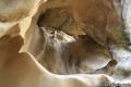
and playground. There is lots of really cool small caves the kids will remember this place Forever. One really cool spot is a small tunnel 10 or 12 foot long. 2 to 2 1/2 ft diameter tunnel. Some spots they can stick their head out of the rock. Wrap a Scarf around Neck bring fake blood and other Halloween make up so it will look like a Deadman’s Head on a Rock. Taller people can put their head out one hole, foot out another and hand out another.
One of my Favorite I call “The Condo”. It is a 5′ x 5′ x 5′ Cave with its face and one side gone, directly above it is another carved out pocket 5′ x 5′ x 5′ facing 90 degree.
There is about 10 or 12 Caves which fit one to 6 people.
Most of these Rocks aka Outcrops range in Height from 2 to 8 feet. about 15% are up to 10 feet and only 2% about 3 to 4 Spots are up to 18 foot.
The walk (not hike) is only 5 minutes or less from the Road to the Rocks.
It has a very nice view of the UCSB Campus and the Houses and small apartments known as Isle Vista. Santa Barbara City is actually not really viewable from Lizards Rock since it faces West but the City of Santa Barbara is South of it.
When you get done at Lizards Mouth take the Kids, small young ones and Old Tall ones to Cold Springs Tavern that is only 15 minutes away from Lizards Mouth. They have Venison, Crocodile, Armadillo, Ostrich, Buffalo, Crown Rack of Lamb and normal beef, chicken or veggie meals at very reasonable prices. The exotic meals vary with availability and season.they also have wine bottles 15 or 20 bucks up to very exotic and expensive.
At about 1 to 2 hours before sunset they have live music outside of the Restaurant and Bar. These old Buildings were once used by the Stage Coach Driver, Scout, Guard, and Passengers. A natural spring brings cold water out 9f the Rocks and becomes a creek then spills to gully then gulch. The stage coach would stop here near top of the trail through the mountains so they could rest and water the horses for the Stage Coach. In Back of the Restaurant is a small shack that 4 passengers would sleep in. It is only 6′ tall, and room was 6′ x 8′. But from outside it looks only just a little bigger than an outhouse. Have fun, I know the Kids young and old will.
I hate the advertising of these local spots. Ruins it. Why advertise for children? Jeez. I won’t ever go there again. Another paradise lost
Grumpy Gus
Can u ride mountain bikes out there??
you could ride nearby. even could get to top of lizards mouth. but you would need to carry the bike over a few spots 10-20 feet that are too rocky.
[…] Head up Highway 154 to explore the ruins of Knapp’s Castle and boulder your way through Lizard’s Mouth. […]