Tequepis Trail
in the Los Padres National Forest
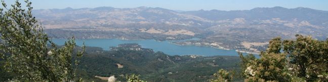
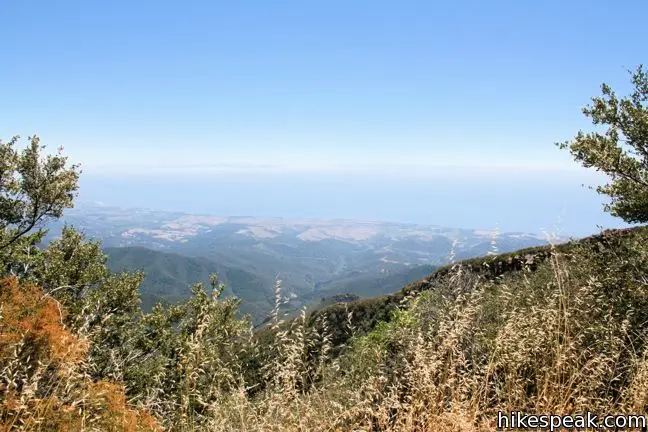
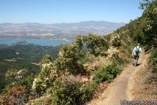
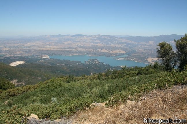
Tequepis Trail begins near the shores of Lake Cachuma and ascends the north side of the Santa Ynez Mountains behind Santa Barbara. The trail up offers views of the lake and valley, and there are broader ocean views from the top. This is an invigorating 8.4-mile round trip hike with 2,300 feet of elevation gain.
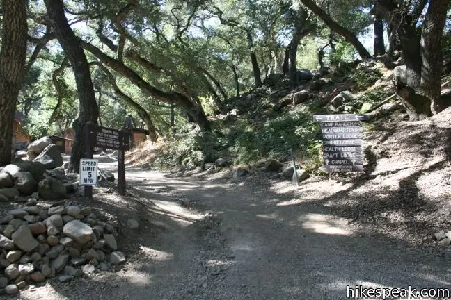
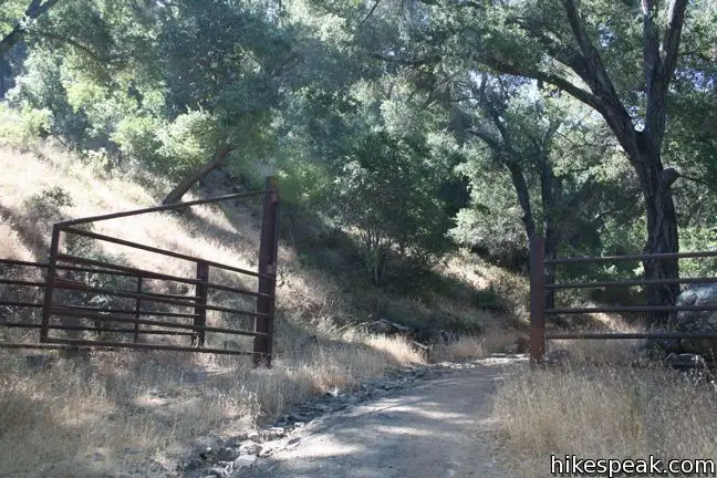
To reach Tequepis Trail, start at the free parking lot at the entrance of Circle V Camp. Follow the dirt road straight through the camp past a swimming pool and bunkhouses. After 0.2 miles, step over Tequepis Creek and pass through a large metal gate. This is the boundary of the Los Padres National Forest and the start of Tequepis Trail.
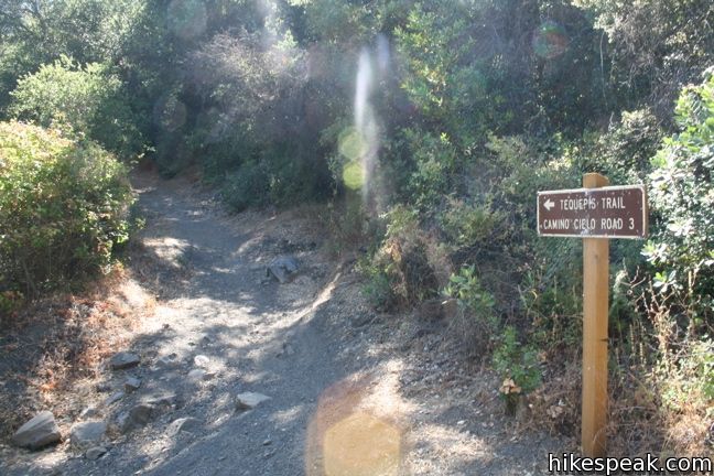
Continue south on the wide gravel road through two early junctions. A tenth of a mile past the gate, go straight, or slightly to the right, past an unmarked road. Then 0.2 miles later, follow the sign to the left at a second intersection. Beyond this point, Tequepis Trail has no more junction to worry about until you reach the top.
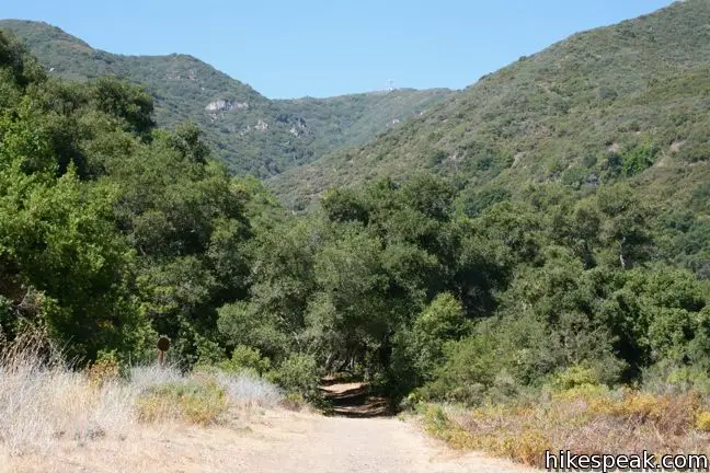
Abundant shade covers the trail as you ascend gradually uphill along the bank of a seasonal toward the back of Tequepis Canyon. The trail dwindles from a service road to a single track. After 1.1 miles, you will reach a sign at a sharp left turn in the trail. This is the start of the switchbacks, three miles and 1,750 vertical feet below the top of the trail.
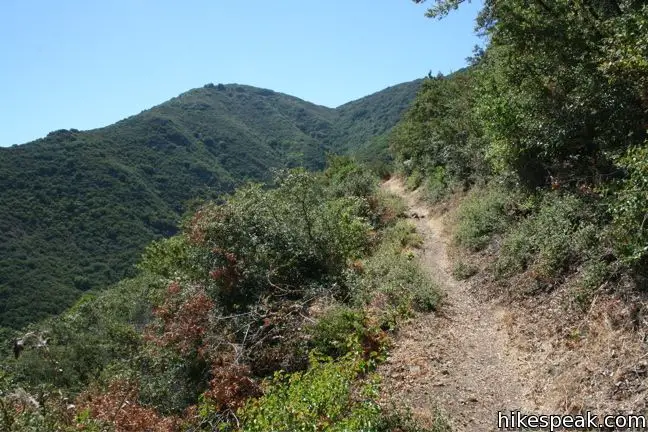
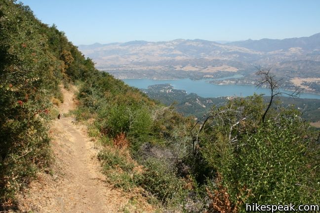
Less than half a mile past the sign, the trail leaves the shade of the forest for sun-exposed chaparral covered slopes. Climb a steep bit of trail (the steepest of the hike) before returning to more gradual terrain. The climb continues in earnest, with a couple more steep sections breaking up the steady grade.
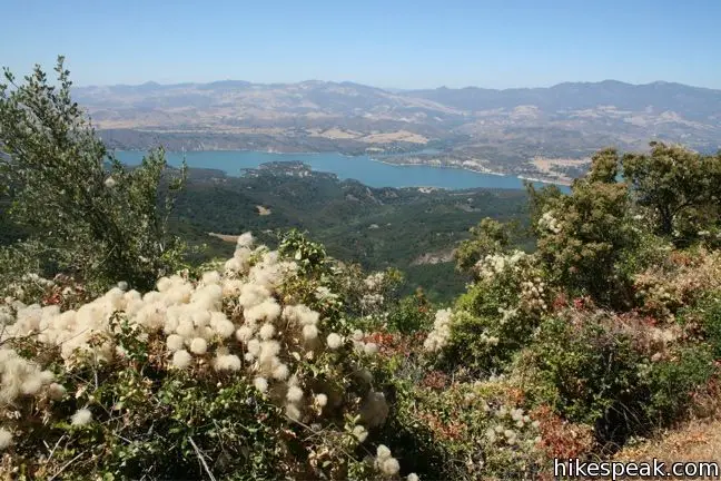
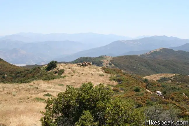
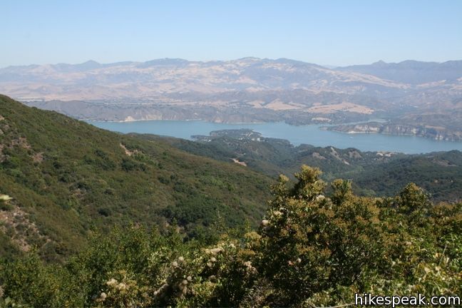
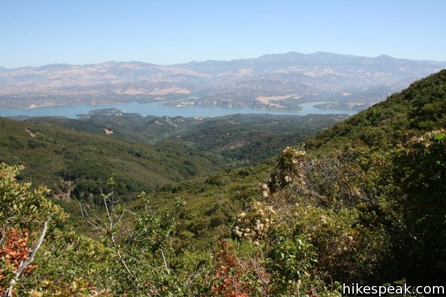
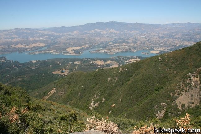
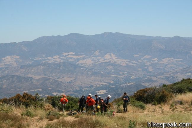
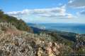
The ascent is relentless, but the views only improve as you climb. The missing shade is replaced by sweeping sights of Lake Cachuma and the surrounding area. The lush slopes make Tequepis Trail a hummingbird haven. Unfortunately, the trail is also home to enormous, almost bird-sized, mosquitoes. Persevere past these pests up the long series of switchbacks. This nonstop climb to the top in a fulfilling exercise of endurance.
Just below the top of the trail, you will pass through a mixed forest of tall trees and ferns. As you crest the ridge of the mountain, the vegetation gives way to a grassy clearing with oceanic views. The moment the trail stops climbing, it shrinks and becomes hard to follow. A faint path to the left crosses through the grasses down to Camino Cielo, a scenic fire road along the top of the range. If you intend to turn around at the top of the trail, you don’t have to worry about this path. Simply walk across the grass to the south and lose yourself in the view of Santa Barbara and the ocean beyond. On a typical day the Channel Islands can be seen on the horizon.
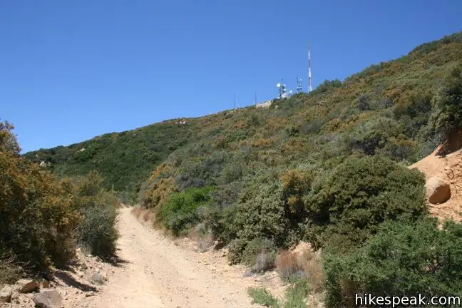
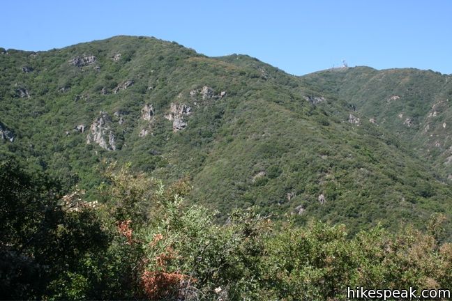
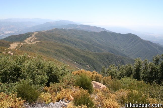
After hiking 4.2 miles with 2,300 feet of elevation gain, you may be wishing you were standing on a summit (getting that satisfaction that only a peak can provide), but Tequepis Trail ends at a saddle east of Broadcast Peak (albeit a scenic one).
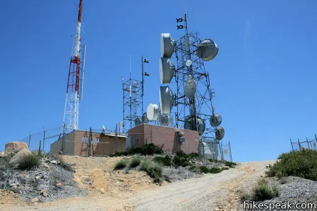
Though the mountaintop looks deceptively near, no direct path leads up to the radio tower-covered top of Broadcast Peak, making it a 1.5-mile add-on, with an additional 475 vertical feet. To summit Broadcast Peak, follow Camino Cielo to the west. On the far side of the summit, make the first right up a service road to the 4,025-foot summit. To the west, Camino Cielo continues to Santa Ynez Peak and farther down the range.
A circle around the installations at the summit offers views in every direction. While this extension provides grander views than the top of Tequepis Trail, it expands the hike to 11.5 miles — quite a lot for a day hike. If you are interested in experiencing westerly views without all the hiking, consider Lizard’s Mouth, a short trail just of Camino Cielo with almost no elevation gain.
Whether you extend the hike or not, once you turn around, it is all downhill! The track that took two hours to climb, will now take just an hour and a half to descend. This still gives you plenty of time to enjoy the fine views of the reservoir below and the San Rafael Mountains to the north. No fee or permit is required to hike Tequepis Trail, so get out and enjoy.
Directions to the Trailhead
- From Santa Barbara, take the 154 north toward Lake Cachuma.
- Continue 7.7 miles past Cold Springs Arch Bridge and turn left at the sign for Circle V Ranch.
- This is the second turnoff with a sign for Camp Allegre.
- If you reach the entrance for Lake Cachuma Recreation Area, you have gone half a mile to far.
- From the turnoff, take the road to the left and drive 1.3 miles to the parking lot at the end of the road outside Circle V Camp - Saint Vincent de Paul Camp.
Trailhead Location
Trailhead address: Forest Route 6N04, Los Padres National Forest, Santa Barbara, CA 93105
Trailhead coordinates: 34.5525, -119.9565 (34° 33′ 09″N 119° 57′ 23.4″W)
View Santa Ynez Mountains in a larger map
Or view a regional map of surrounding Central Coast trails and campgrounds.


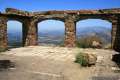
 | Lizard's Mouth This half-mile hike offers amazing views over Santa Barbara and the Pacific while visiting a unique rock formation. |
 | Knapp's Castle This easy 0.8-mile hike visits the scenic ruins of an estate home built atop the mountains behind Santa Barbara. |
 | Nojoqui Falls This short 0.65-mile hike visits an 80-foot tall fern-lined waterfall. |
 | Gaviota Peak This 6.5-mile loop mounts a 2,458-foot summit two miles from the Pacific and then descends Trespass Trail to explore the wilds of the Santa Ynez Mountains. |
 | Gaviota Wind Caves This 2.5-mile hike just off Highway 101 visits wind-carved caves in Gaviota State Park with great ocean views. |
 | Gaviota Hot Springs This short hike visits a warm hot springs along the trail to Gaviota Peak in Gaviota State Park. |
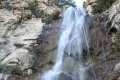 | Tangerine Falls This 2.5-mile hike visits a beautiful waterfall on the edge of Los Padres National Forest near Santa Barbara. |
 | Montecito Peak This 7.1-mile partial loop climbs to a panoramic summit in Los Padres National Forest overlooking Montecito and Santa Barbara. |
 | McMenemy Overlook This 3.7-mile hike uses four trails to form a loop through the mountains behind Montecito, California. |
 | More Central Coast Hikes Explore other destinations along the California coast between Ventura and Monterey, including trails in Los Padres National Forest. |
Common Questions about Tequepis Trail in the Los Padres National Forest
- Is the trail open?
- Yes. You should expect to find that Tequepis Trail is open. There are no recent reports of trail closures. If you discover that the trail is closed, please help your fellow hikers by reporting a closure.
- Is this trail free to access?
- Yes, Tequepis Trail is free to access. No entrance fee, pass, or permit is required. If you discover that access rules have changed, please provide feedback on your experience.
- How much time does this hike take?
- It takes approximately 5 hours to hike Tequepis Trail. Individual hiking times vary. Add extra time for breaks and taking in the views.
- How long is this hike?
- The hike to Tequepis Trail is a 8.4 mile out and back with 2300 feet of elevation change.
- Are dogs allowed on this trail?
- Yes, dogs are allowed on Tequepis Trail. The trail is open to hikers, bikes, dogs.
- Is Tequepis Trail a difficult hike?
- This hike should be considered strenuous. Hikers should be prepared for a workout covering 8.4 miles and 2300 feet of climbing.
- Are there ocean views on this hike?
- Yes, Tequepis Trail offers views of the ocean.
- Where is the trailhead located?
- The trailhead for Tequepis Trail is located in Santa Barbara, CA.
Trailhead Address:
Forest Route 6N04
Santa Barbara, CA 93105
Trailhead Coordinates:
34.5525, -119.9565 - What are the driving directions to the start of the hike?
To get to the trailhead: From Santa Barbara, take the 154 north toward Lake Cachuma. Continue 7.7 miles past Cold Springs Arch Bridge and turn left at the sign for Circle V Ranch. This is the second turnoff with a sign for Camp Allegre. If you reach the entrance for Lake Cachuma Recreation Area, you have gone half a mile to far. From the turnoff, take the road to the left and drive 1.3 miles to the parking lot at the end of the road outside Circle V Camp - Saint Vincent de Paul Camp.
View custom Google Maps directions from your current location.
- Are there other trails near Tequepis Trail?
- Yes, you can find other nearby hikes using the Hikespeak Hike Finder Map.

5 Comments on Tequepis Trail in the Los Padres National Forest
What hikers are saying:
✨ Generated summary of user commentsHikers prepare for this journey by packing plenty of water and snacks to stay fueled. Because the trail lacks backcountry camping spots, visitors should treat this as a day trip rather than an overnight adventure.
Are there any hike-in campgrounds along this trail?
I don’t believe there are any backcountry camping spots along the trail
[…] Umm, plan ahead unlike us and fill up your water bottles and pack snacks before you leave Santa Barbara. Once you’re outside of town, there’s nowhere to stop along the way unless you overshoot the trail. Other great trail information can be found on Hikes Peak. […]
How technical is this climb via mountain bike? 2300 feet is noted. Also..would it be a drive in from Cachuma Lake or close enough to ride from the campground to trail head?
Definitely will pack lots of water & snacks!
[…] We were a little confused and had a little difficulty finding the Tequepis trailhead. We finally just read the signs and followed the markers and found the trail. The trail gave expansive views of the mountains. If we continued on we probably would have reached the Pacific Ocean! We decided to turn around after a nice hike […]