Cerro Cabrillo and Tiki Rock
in Morro Bay State Park
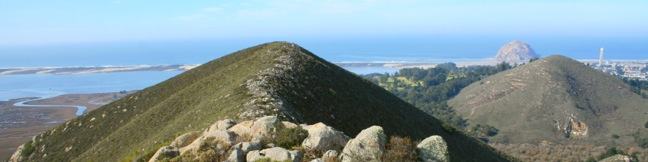
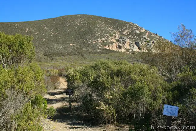
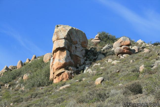
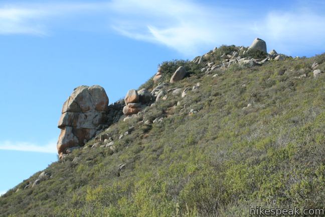
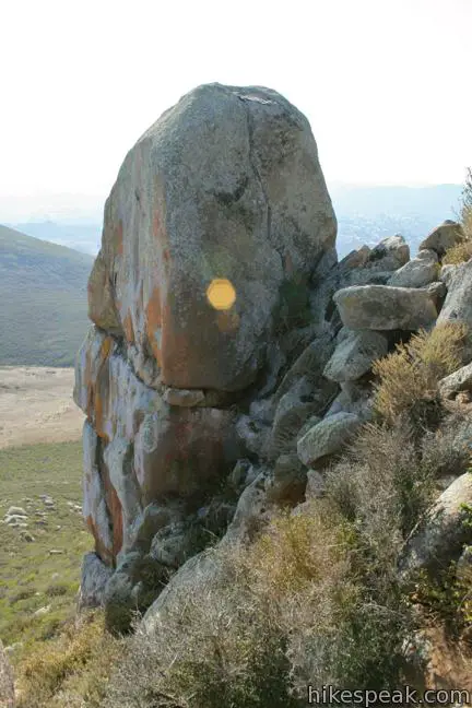
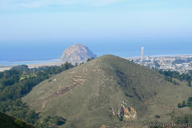
Nine principle volcanic plugs are spread between the central coast cities of Morro Bay and San Luis Obispo. The 911-foot Cerro Cabrillo (or Cabrillo Peak) is the third of the Nine Sisters from the west after Morro Rock and Black Hill. The summit of Cerro Cabrillo is the highest point in Morro Bay State Park, offering panoramic oceanfront views. The unmaintained trail to the summit passes Tiki Rock, an unmistakable boulder near the top of the peak resembling those carved by Polynesians. It is 2.5 miles round trip to the summit with 900 feet of elevation gain. The trail is slippery and rutted in areas, and some light rock climbing is required to top the boulder-covered summit.
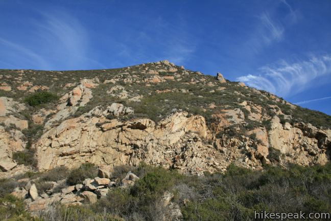
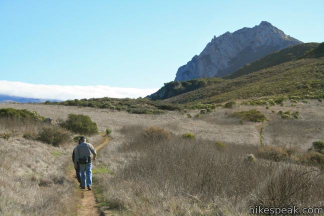
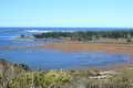
Begin from a trailhead on the east side of South Bay Boulevard across from Morro Estuary between the cities of Los Osos and Morro Bay. Take Quarry Trail, heading northeast toward Cerro Cabrillo. Hike 0.17 miles to a junction with Chorro Trail and angle right to remain on Quarry Trail. Chorro Trail heads north for 0.9 miles to Turtle Rock, a mini-summit between Cerro Cabrillo and Black Hill. You may see mountain climbers tackling bluffs on the rocky southern face of Cerro Cabrillo as you continue another third of a mile east to a junction with Live Oak Trail on the right. This trail can be used to reach Portola Point for an impressive overview of Morro Bay. For Cerro Cabrillo continue hiking east through a meadow of grass and sage in the direction of Hollister Peak. This first half mile of the hike has great over-the-shoulder views of Morro Bay.
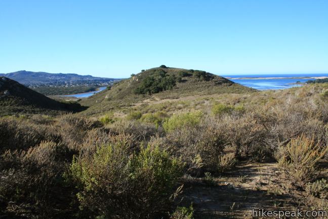
About a quarter mile past the junction with Live Oak Trail, take the first available left, departing up a grassy slope on a dirt single track aimed directly at Tiki Rock, an orange head-shaped boulder jutting out of the mountainside 75 feet below the crown.
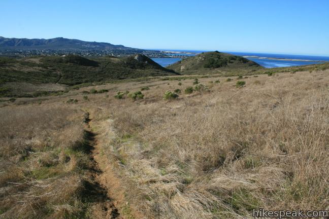
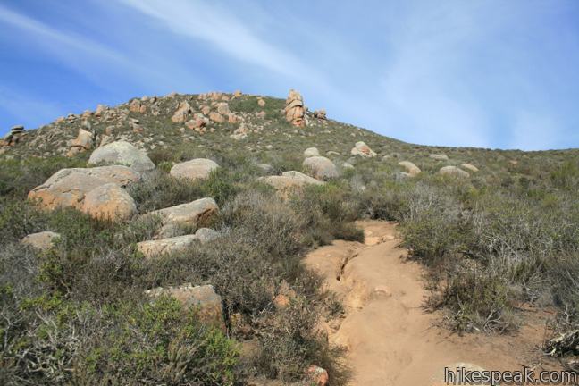
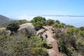
The trail to Tiki Rock and the summit of Cerro Cabrillo is not maintained by the park, which becomes apparent as you hike up a steep track of rutted and loose dirt. Paths diverge to the left and right, but stick to the main trail heading up the mountain toward Tiki Rock. The surrounding slopes of sage provide open views and a pleasant fragrance along the trail.
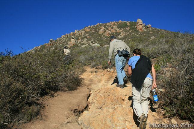
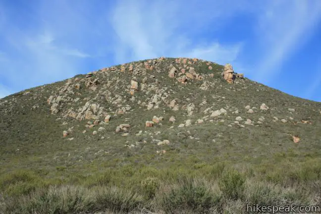
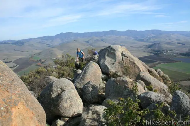
After climbing 525 feet above Quarry Trail in 0.4 miles, you will come even with Tiki Rock. To the left, a spur trail extends a hundred feet to the impressive pillar. To reach the top, angle to the right up a use trail over suddenly rocky terrain. Curl around the right side of a cone-shaped boulder and push for the top, scrambling over and around boulders on a worn, but less-traveled track to the summit. Beware of poison oak striking up around the rocks as you climb 0.05 miles above Tiki Rock to the peak of Cerro Cabrillo.
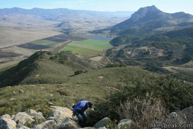
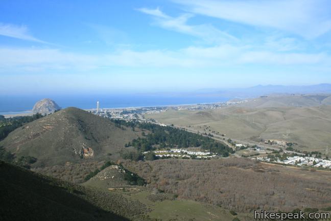
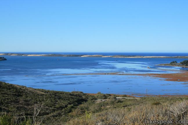
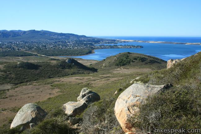
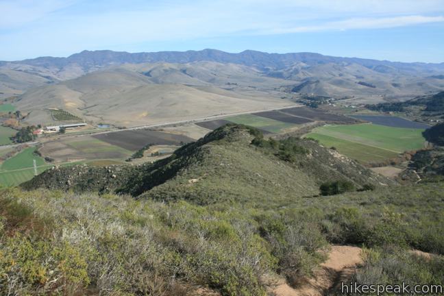
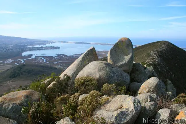
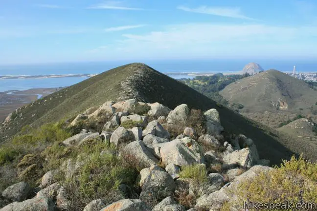
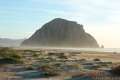
The view from the top is worth the effort. Look west across a rocky saddle toward a second slightly-shorter summit of Cerro Cabrillo. Off the north side of the mountain is Black Hill, Morro Rock, and miles of beach stretching toward San Simeon. To the south is Morro Bay, Los Osos, and the mountains of Montaña de Oro State Park, including Valencia Peak (another summit with excellent ocean views). The 1,404-foot Hollister Peak rises to the southeast and Chorro Valley and the Santa Lucia Mountains can be seen to the east. It is a fantastic coastal panorama.
After enjoying the 360 degree views, return the way you came. Despite only being the 6th tallest of the Nine Sisters, Cerro Cabrillo delivers a strenuous hike. To extend your time in Morro Bay State Park, consider hiking to Turtle Rock (adding 1.8 miles) or Portola Point (adding 1.5). Both of these short overlapping hikes make a great warm-up for Cerro Cabrillo. Dogs are not permitted on trails in Morro Bay State Park. No fee or permit is required to hike Cerro Cabrillo, so get out and enjoy!
Directions to the Trailhead
- From Highway 1 in Morro Bay, take exit 277, following signs for Los Osos and Baywood Park.
- Turn south on South Bay Boulevard.
- Drive 1.4 miles to the trailhead parking area, set a few meters back from the road on the left.
- From Highway 101, south of San Luis Obispo, take exit 200A onto Los Osos Valley Road.
- Drive 9.8 miles west to South Bay Boulevard.
- Turn right on South Bay Boulevard.
- Drive 2.6 miles north to the trailhead , which is on the right, 0.4 miles past Turri Road.
Trailhead Location
Trailhead address: South Bay Boulevard, Morro Bay, CA 93442
Trailhead coordinates: 35.34652, -120.8252 (35° 20′ 47.5″N 120° 49′ 30.7″W)
View Morro Bay State Park in a larger map
Or view a regional map of surrounding Central Coast trails and campgrounds.


 | Turtle Rock This easy 2.1-mile hike reaches a short rise between Black Hill and Cerro Cabrillo in Morro Bay State Park. |
 | Portola Point This 2-mile loop explores a short hill just east of Morro Estuary in Morro Bay State Park. |
 | Chumash & Crespi Trails Loop This 2.9-mile circuit in Morro Bay State Park visits an oak grove and bay views by combining Chumash Trail, Crespi Trail, and Hutash Trail. |
 | Black Hill This short 0.6-mile out and back hike ascends 175 feet to the summit of Black Hill, which presents 360-degree views over Morro Bay. |
 | Morro Rock via Morro Strand Trail This level one to 3.5-mile round trip hike starts from Cloisters Park and crosses Morro Strand State Beach to reach Morro Rock. |
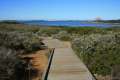 | Elfin Forest Natural Reserve This easy 1-mile loop on a boardwalk explores a pygmy forest on the edge of Morro Bay. |
 | Morro Dunes Ecological Reserve This 2.6-mile loop serves up panoramic views over Morro Bay as it ascends 800 feet from Los Osos to Montaña de Oro State Park. |
 | More hikes in San Luis Obispo Explore other trails around San Luis Obispo including Montaña de Oro State Park and the Morros. |
Common Questions about Cerro Cabrillo and Tiki Rock in Morro Bay State Park
- Is the trail open?
- Yes. You should expect to find that Cerro Cabrillo is open. There are no recent reports of trail closures. If you discover that the trail is closed, please help your fellow hikers by reporting a closure.
- Is this trail free to access?
- Yes, Cerro Cabrillo is free to access. No entrance fee, pass, or permit is required. If you discover that access rules have changed, please provide feedback on your experience.
- How much time does this hike take?
- It takes approximately 1 hour 30 minutes to hike Cerro Cabrillo. Individual hiking times vary. Add extra time for breaks and taking in the views.
- How long is this hike?
- The hike to Cerro Cabrillo is a 2.5 mile out and back with 900 feet of elevation change.
- Are dogs allowed on this trail?
- No, dogs are likely not allowed on Cerro Cabrillo. The trail is primarily open to hikers.
- Are there ocean views on this hike?
- Yes, Cerro Cabrillo offers views of the ocean.
- Does this trail go to a summit?
- Yes, Cerro Cabrillo reaches a summit with panoramic views.
- Where is the trailhead located?
- The trailhead for Cerro Cabrillo is located in Morro Bay, CA.
Trailhead Address:
South Bay Boulevard
Morro Bay, CA 93442
Trailhead Coordinates:
35.346512, -120.8252 - What are the driving directions to the start of the hike?
To get to the trailhead: From Highway 1 in Morro Bay, take exit 277, following signs for Los Osos and Baywood Park. Turn south on South Bay Boulevard. Drive 1.4 miles to the trailhead parking area, set a few meters back from the road on the left.
From Highway 101, south of San Luis Obispo, take exit 200A onto Los Osos Valley Road. Drive 9.8 miles west to South Bay Boulevard. Turn right on South Bay Boulevard. Drive 2.6 miles north to the trailhead , which is on the right, 0.4 miles past Turri Road.
View custom Google Maps directions from your current location.
- Are there other trails near Cerro Cabrillo?
- Yes, you can find other nearby hikes using the Hikespeak Hike Finder Map.

7 Comments on Cerro Cabrillo and Tiki Rock in Morro Bay State Park
What hikers are saying:
✨ Generated summary of user commentsHikers find this trail rewarding for its fun boulder scrambling and amazing ocean views. The descent requires caution due to slippery loose rock, making steady footing essential for a safe return.
“The rock scrambling is fun, too.” Jump to comment ↓
This is the real Tiki Rock… you kinda missed the good stuff, it’s an incredible hike.
https://morro-bay.com/outdoor/cabrillo/tiki-rock-small-at-cerro-cabrillo-in-morro-bay.jpg
No dogs permitted in Morro Bay State park Trails
[…] Cerro Cabrillo and Tiki Rock […]
great hike! fun to tackle boulders to get to the top, super slippery loose rock coming down – slid on my butt most of the way then bit it when I stood up close to the end. Ah well, it’s not a proper hike without a war wound. Not a long hike, but challenging to get to the top.
Amazing ocean view hike. The rock scrambling is fun, too. Check out my blog about this hike at https://adulthoodinslo.wordpress.com/2017/03/13/cerro-cabrillo-hike-in-morro-bay/!
[…] Cerro Cabrillo and Tiki Rock […]
This afternoon, 3-28-2020, was my second trip to Cerro Cabrillo State Park, SLO County. Coming home, I was hoping to see a trail map that displayed milages. Any clues?
Thank you,
Allen Root