Cerro Alto
in San Luis Obispo
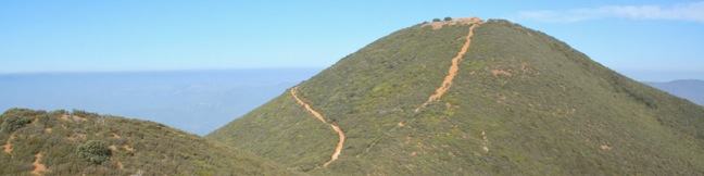
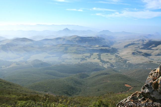
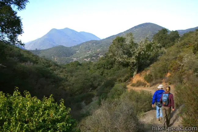
The 2,624-foot summit of Cerro Alto is one of the highest points in San Luis Obispo County and delivers a panoramic view. It seems like you can see the entire county from the top of the commanding peak, including each of the volcanic peaks stretching between Morro Bay and Edna Valley, the Nine Sisters. There are a couple ways to the summit, each tackling 1,600 feet of elevation between the trailhead at Cerro Alto Campground and the cerro’s summit. The shortest route is a steep 1.95-mile ascent. A more gradual trail can be taken to a junction part way up the mountain for a 2.75-mile route that is recommended for the hike up. Additionally, a spur trail out to a ridge south of the summit adds 0.65 scenic miles to the hike. These trails can all be combined for a 5.35-mile trek with high views over Los Padres National Forest, and the route following is not as complicated as it might sound.
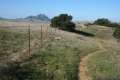
Cerro Alto Campground is tucked away in an oak forest off Route 41 between Morro Bay and Atascadero. Two trails to the summit of Cerro Alto start from a parking area at the end of the mile-long road through the campground. The gradual route begins near campsites 18 and 19 next to a large sign that reads, “Cerro Alto Trail 12E01.” The steeper route can be found a hundred yards back down the road on the left. Simply labeled “trail,” the single track drops across the East Fork of Morro Creek and begins a strenuous climb up the mountain. Unless you want to punish yourself, save this trail for the way down. For the hike up, pick the gradual trail starting next to that big national forest sign.
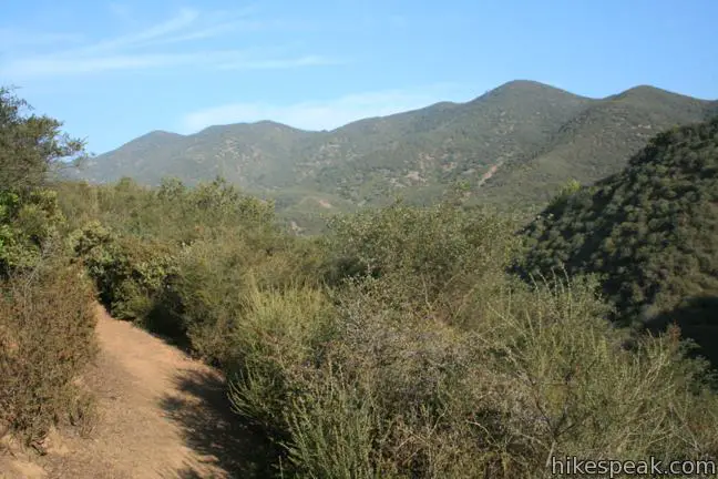
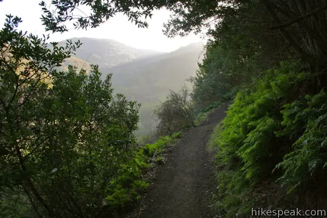
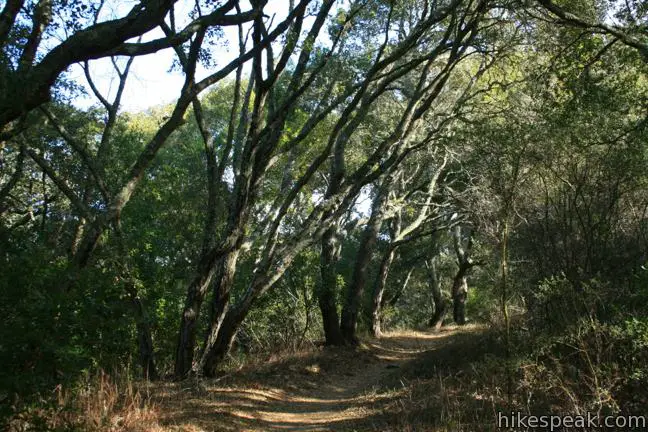
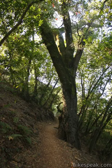
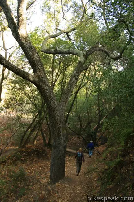
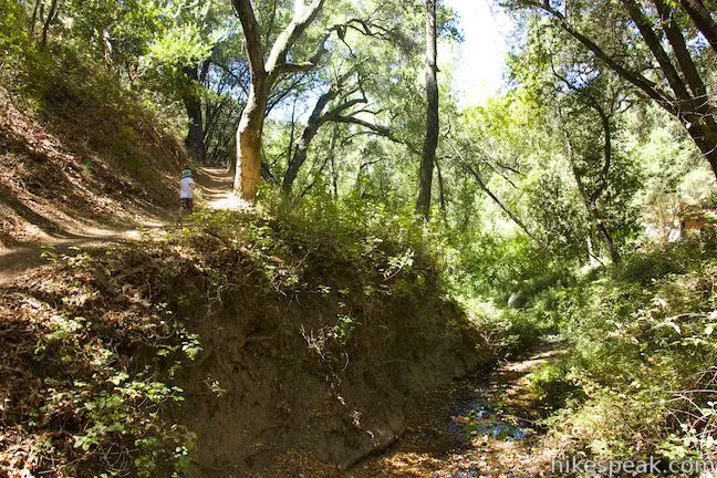
The first half mile is surprisingly level, heading east along the creek. Ferns line the early part of this trail, shaded by a canopy of oaks. Eventually, the trail leaves the canyon and angles south up the mountain.
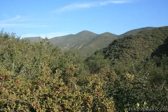
At a junction, 0.95 miles from the start, turn right following a wooden sign for the summit. Above the junction, you will quickly pass two paths breaking off to the left that form a brief detour that avoids a short steep section of the trail. Just over half a mile from the junction, the trail wraps around the north side of the mountain for a fine perspective over the canyon containing Cerro Alto Campground. Frog Pond Peak rises to the northeast, flanked by green ridges and canyon. A bench here makes it easy to admire the view.
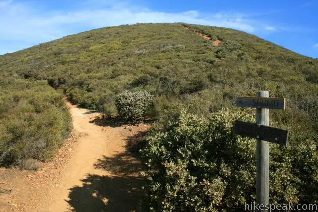
The trail turns west leveling out just long enough for you to catch your breath before the real ascent. At a four-way junction, 1.7 miles and 650 vertical feet from the start, turn left following the wooden sign for the summit. The more direct route up from the campground is to the right, directly across from the summit trail. Straight ahead, an AT&T Cable Road continues over the range toward West Cuesta Ridge Road.
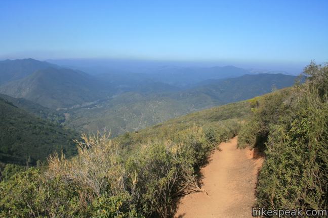
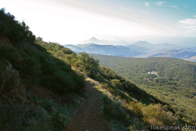
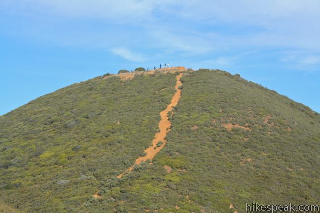
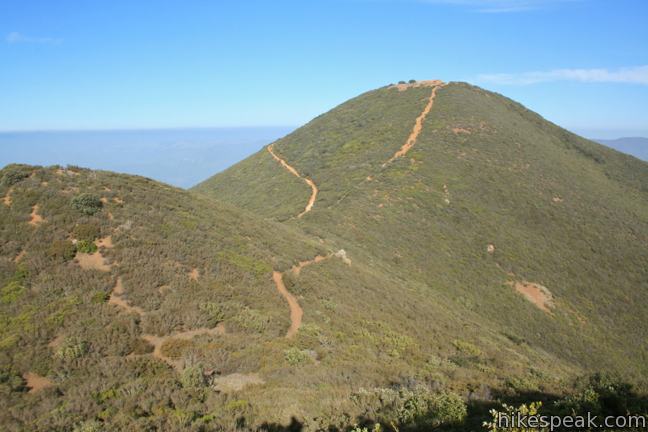
The Summit Trail can no longer afford to be gradual. Climb straight up the chaparral-covered mountainside, picking up 400 feet in the next half mile up to an unmarked junction. The split comes shortly after the trail presents its first western view over Morro Bay. Both trails leaving the junction reunite at a saddle beneath the summit, but it is advisable to take the shorter route to the left. The alternative route, which continues straight ahead is 0.2 miles longer, but no less steep, adding a few extra views over Morro Bay. To hike this way, go straight past a bench and turn left up Lookout Trail, which switchbacks around the southwest side of a rise west the summit to reach the saddle. The trail departing to the left from the junction is the shorter route, heading up a draw between Cerro Alto and the rise to the west. You get a good view of the summit heading this way, as well as a view north over the range toward Rusty Peak. This is the steepest stretch of the hike, gaining about 375 feet in a third of a mile.
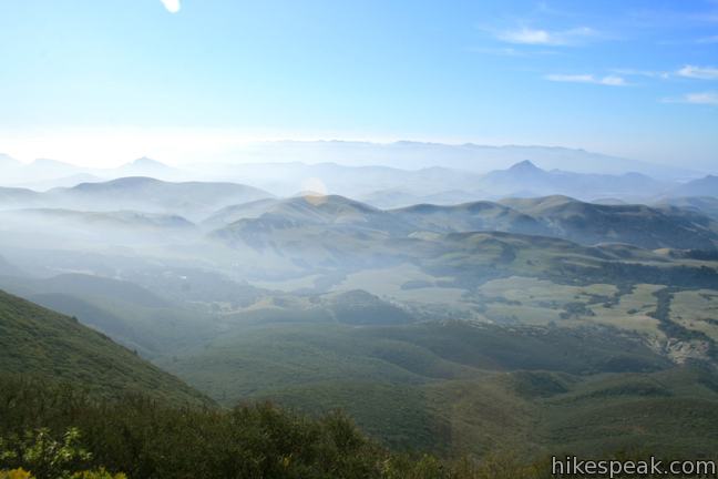
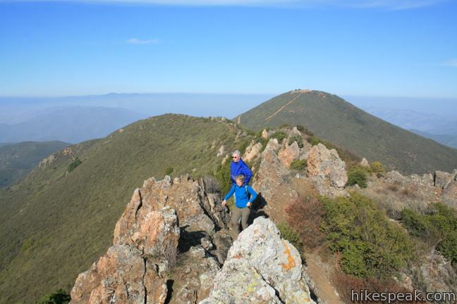
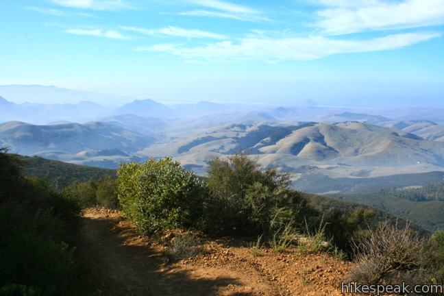
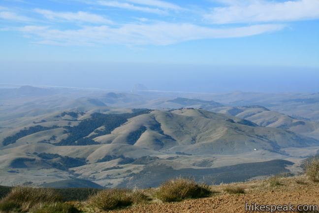
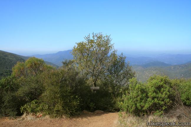
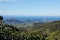
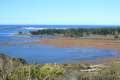
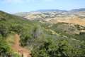
When you reach the saddle, turn left and follow the trail around the north face of Cerro Alto, curling all the way to the east side before reaching the rocky summit. With the exception of the radio-towered summit of Tassajara Peak to the southeast, nothing as tall as Cerro Alto is in sight, making the views immensely panoramic. The entire string of Morros running across San Luis Obispo County is visible to the south, starting with Morro Rock in Morro Bay and ending with Islay Hill in Edna Valley. If you have hiked Cerro Cabrillo, Bishop Peak, or Cerro San Luis, you should have no trouble recognizing these volcanic peaks. From the ocean in the west to the Santa Lucia Mountains in the east, the view is as expansive as you could imagine. Turn around and look in the other direction to see even more – verdant mountains and valley rolling out to the north, bordered by a rugged coastline extending through Cambria and San Simeon. This is a lofty reward earned by a strenuous effort.
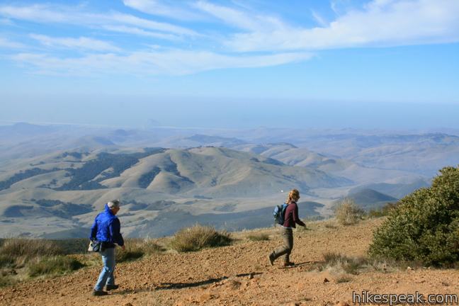
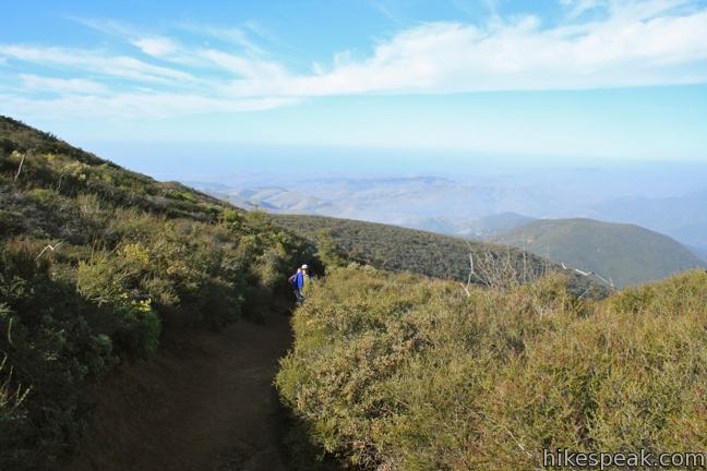
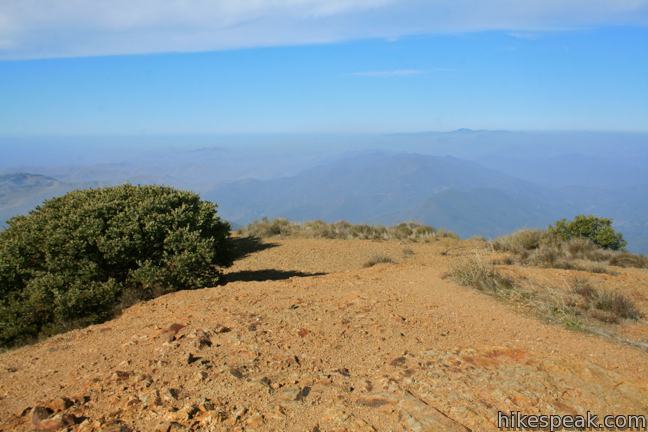
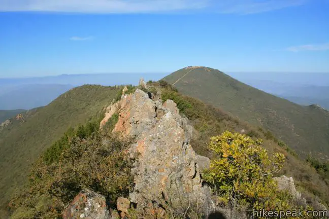
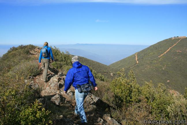
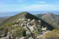
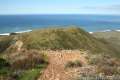
Before you hike all the way back down, there is another view to enjoy. Return to the T-junction at the saddle and walk straight a few steps to a path breaking off to the left (this makes the T-junction more like a t-junction). Follow this rugged Ridge Trail, which quickly mounts the rocky ridge south of Cerro Alto. Why bother hiking out on this ridge, which is less than 100 feet shorter than Cerro Alto? Because the ridge is out of the view. Unlike on the summit, there is no prominent formation to the south to shrink the view. The south face of the ridge drops straight down to Chorro Valley to provide a grander perspective of the Nine Sisters, Irish Hills, Morro Bay, and other icons of San Luis Obispo County.
Follow the path southeast across the spine of the ridge covered in jagged boulders. The terrain is so different from the surrounding tamer mountains that you might think you were transplanted to Pinnacles National Park. After a third of a mile, you will reach the high point of the ridge, which is a great spot to turn around after taking in the unimpeded view. The ridge presents a different experience from the rest of the hike and is a worthwhile addition.
Back at the saddle, return down the mountain to the four-way junction. Cross the AT&T Cable Road and follow the sign for the short trail to the campground. Dropping 650 feet in less than a mile, the trail quickly descends the mountainside of chaparral to enter an oak woodland. Cross a wooden bridge over Morro Creek to reach the paved road a hundred yards from the original trailhead.

A fee of $10 is required to park at the trailhead. Due to an agreement with the concession that manages the campground, a national forest adventure pass or national public lands pass (inter-agency access pass) is no longer accepted in lieu of the day use fee. An annual pass can be could be purchased from Parks Management Company for $50, which would apply to Cerro Alto Campground and other managed sites. These unfortunate concession agreements are far to common at state and national sites on California’s Central Coast.
One of the fine sites at Cerro Alto Campground may be reserved for $25 per night. Dogs are permitted on leash. Mountain bikes are also allowed. No permit is required for the rewarding hike to Cerro Alto, so get out and enjoy!
Directions to the Trailhead
- From Morro Bay, 13 miles northwest of San Luis Obispo on Highway One, take Route 41 northeast for 7.2 miles to the turnoff for Cerro Alto Campground.
- The road into Cerro Alto Campground is on the right.
- Proceed one mile through the elongated campground to the trailhead parking area at the end of the road.
- From Atascadero, 16 miles north of San Luis Obispo on Highway 101, take Route 41 southwest for 9 miles to the turnoff for the campground.
- The campground road is on the left.
- Proceed one mile through the elongated campground to the trailhead parking area at the end of the road.
Trailhead Location
Trailhead address: Cerro Alto Road, Los Padres National Forest, Morro Bay, CA 93442
Trailhead coordinates: 35.424271, -120.738988 (35° 25′ 27.37″N 120° 44′ 20.35″W)
View Cerro Alto in a larger map
Or view a regional map of surrounding Central Coast trails and campgrounds.


 | Cuesta Ridge Botanical Area This 6-mile round trip hike crosses a ridge in the Santa Lucia Mountains with panoramic views over San Luis Obispo, ascending to a grove of Sargent cypress in a botanical area in Los Padres National Forest. |
 | Cerro Cabrillo This 2.5-mile out and back hike summits the highest mountain in Morro Bay State Park, a 911-foot member of the Nine Sisters. |
 | Portola Point This 2-mile loop explores a short hill just east of Morro Estuary in Morro Bay State Park. |
 | Eagle Rock Nature Trail This 2.4-mile hike in El Chorro Regional Park climbs 450 feet to Eagle Rock Viewpoint for an overview of the valley between San Luis Obispo and Morro Bay. |
 | Reservoir Canyon This 5.35-mile hike ascends 1,350 feet past a waterfall and a collection of junk sculptures to a treeless summit overlooking San Luis Obispo. |
 | More hikes in San Luis Obispo Explore other trails around San Luis Obispo including Morro Bay State Park and Montaña de Oro State Park. |
 | Cerro Alto Campground This cozy 22-site campground is the starting point for hikes to Cerro Alto and a perfect place to tent camp in the Los Padres National Forest between Morro Bay and Atascadero. |
Common Questions about Cerro Alto in San Luis Obispo
- Is the trail open?
- Yes. You should expect to find that Cerro Alto Trail is open. There are no recent reports of trail closures. If you discover that the trail is closed, please help your fellow hikers by reporting a closure.
- Do I need a permit for this hike?
- Yes. Day Use Fee.
- How much time does this hike take?
- It takes approximately 3 hours 15 minutes to hike Cerro Alto Trail. Individual hiking times vary. Add extra time for breaks and taking in the views.
- How long is this hike?
- The hike to Cerro Alto Trail is a 5.35 mile out and back / loop with 1600 feet of elevation change.
- Are dogs allowed on this trail?
- Yes, dogs are allowed on Cerro Alto Trail. The trail is open to hikers, dogs, bikes.
- Are there ocean views on this hike?
- Yes, Cerro Alto Trail offers views of the ocean.
- Does this trail go to a summit?
- Yes, Cerro Alto Trail reaches a summit with panoramic views.
- Where is the trailhead located?
- The trailhead for Cerro Alto Trail is located in Morro Bay, CA.
Trailhead Address:
Cerro Alto Road
Morro Bay, CA 93442
Trailhead Coordinates:
35.424271, -120.738988 - What are the driving directions to the start of the hike?
To get to the trailhead: From Morro Bay, 13 miles northwest of San Luis Obispo on Highway One, take Route 41 northeast for 7.2 miles to the turnoff for Cerro Alto Campground. The road into Cerro Alto Campground is on the right. Proceed one mile through the elongated campground to the trailhead parking area at the end of the road.
From Atascadero, 16 miles north of San Luis Obispo on Highway 101, take Route 41 southwest for 9 miles to the turnoff for the campground. The campground road is on the left. Proceed one mile through the elongated campground to the trailhead parking area at the end of the road.
View custom Google Maps directions from your current location.
- Are there other trails near Cerro Alto Trail?
- Yes, you can find other nearby hikes using the Hikespeak Hike Finder Map.

29 Comments on Cerro Alto in San Luis Obispo
What hikers are saying:
✨ Generated summary of user commentsHikers find this trail breathtaking, offering views that can stretch as far as the Sierra Nevada peaks on clear days. The path features diverse native foliage and abundant birdlife, though the steep descent can be taxing on the legs. Pierre advises being careful not to turn toward TV Tower road when heading down.
“Even if you don't make it all the way to the ridge, the views are breathtaking.” Jump to comment ↓
“Beautiful hike all the way especially if appreciate native foliage.” Jump to comment ↓
Are dogs allowed on leash
They sure are. Enjoy the hike!
Hi-
There aren’t any signs about horses posted at the trailhead, just a sign prohibiting motorized vehicles. I don’t recall any signs of horses along the trails. Please share if you are able to ride there.
Hiked this yesterday with a Meetup group. We read your description before our hike and were glad we did because as you had suggested above, we hiked out on the short the ridge trail. “The south face of the ridge drops straight down to Chorro Valley to provide a grander perspective…”
We were indeed treated to even more awesome perspective. There was a greater diversity of plants growing among the rocks on this ridge and the swallows were in abundance flitting around us as we stood (carefully) on the top of the cliffs.
To begin our hike, we chose the steep 1.95-mile ascent and came down the AT&T Cable Road. We found this easier on our knees.
Thank you for the detailed descriptions on your website. We appreciate the maps and photos.
Thanks for the feedback. Glad you enjoyed the hike!
Does the America the Beautiful pass work here (which covers national parks and federal recreational lands), or do you specifically need the national forest adventure pass? Thanks!
Great question. The America the Beautiful pass works as well. Enjoy the hike!
[…] also discovered that Cerro Alto is the best hike on the California Central Coast. For reals. It’s about a three mile hike up one of the tallest mountains in the county, and it […]
Have a 6 month pregnant wife and a 3 1/2 year old daughter. Is there a friendly hiking spot at this site?
Sunday hike?
Are horses allowed in Cerro Alto?
On an exceptionally clear day, the morning of 3/9/2014, we could see the Sierra Nevada peaks around Sequoia National Park (62deg east of true north) from the ridge trail.
is this a mountain bike trail as well? or no bikes allowed? looking for good trails near Paso Robles on vacation. like big hills up and especially down!
Bikes are allowed. Enjoy your ride!
I visited this trail after finding this article. It was absolutely beautiful. Unfortunately, I did not hike the ridge, but I will next time! Thank you very much for the directions to an amazing trail.
Are horses allowed on the Cerro Alto Trail?
One of my favorite hikes on the Central Coast. Even if you don’t make it all the way to the ridge, the views are breathtaking. Lots of little side trails to explore as well – one leads down to a lovely Eucalyptus grove. This trail also meets up with the West Cuesta Ridge trail, which is an incredible 12+ mile hike one way (so you have to park a car at either side) but it takes you through a lovely botanical area. As far as horses, I’ve probably hiked the trails in and around Cerro Alto 20+ times and have never encountered horses. Not sure if they are not allowed or if the trails are simply not horse friendly. Lot’s of mountain bikers and dogs, however. Highly recommend this hike if you are in the area.
This sound great!!! I am staying in Paso w. my boyfriend and we plan to wine taste. But I am more into hiking… eekkkk he wine tasting. Is there anything closer to Paso that can get us rocking in like 2 hours max? Or if we did this hike… can we accomplish plenty in 2 hours… cuz there is 30 minutes each way driving… It looks amazing!!! Thanks!!!!
Great info and beautiful pictures. I am from Utah and new to Morro Bay. You mentioned a Meet Up group. I love to hike but I don’t dare do it alone. If you can tell me how to get in touch with a group that would be great. Thanks again
Took two hours to hike to the ridge. Beautiful hike all the way especially if appreciate native foliage.
Is the Golden Age passport valid here, for Cerro Alto ?
Yes, that should work. Enjoy the hike!
a short update on Cero Alto, parking fee is $ 5 per day, golden age pass 50% off. Coming down be careful not to make a left towards TV Tower road. Many thanks for the website.
Great hike. A day pass is $5.00, not $8.00. I didn’t see any signs prohibiting camping on the summit. I wonder if that’s OK to do?
are dogs allowed on cerro alto trail
yes
Amazing!!! Need more great hikes when up in wine country!!! This was crazy amazing.. almost killed my boyfriend..lol… it got steep…. as a cycler having put in a few miles lately I was good… but way down a bit tired n slower!
So you know…campsites are now $25 a night, day use $10. Federal or national passes are only applicable for camping fees. The only pass that will reduce fees for day use is the Park Management Pass, available from the concessionaire.
Thanks for posting. That’s unfortunate to hear, but I’ve update the information.