South Hills Ridge Trail
in San Luis Obispo
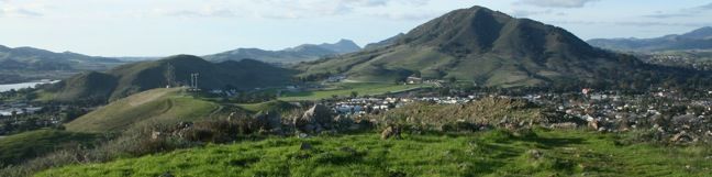
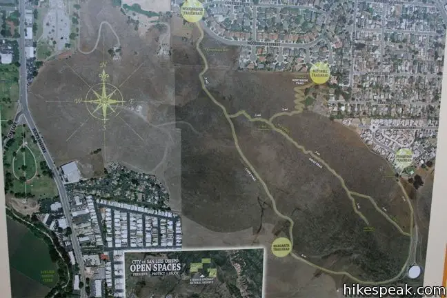
While shorter than the more celebrated peaks around San Luis Obispo (those attention-seeking Morros known as the Nine Sisters), the 580-foot summit of the South Hills provides excellent easy-to-reach views of San Luis Obispo. A perimeter loop trail tours the 133-acre South Hills Open Space, along with a ridge trail that provides a 1.5-mile round trip hike as it ascends 450 feet to the top of the green space just south of downtown San Luis Obispo.
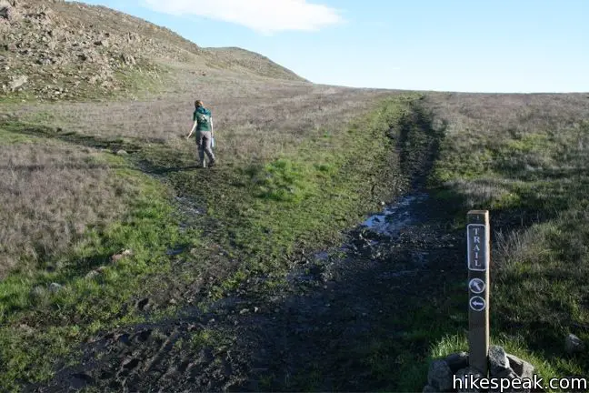
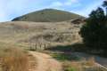
South Hills Open Space has a few access points. The Ridge Trail hike begins from the Woodridge Trailhead, 0.2 miles south of South Street on Exposition Drive. Large signs at the trailhead describe the plants and animals living in South Hills Open Space, along with an aerial map of the trail.
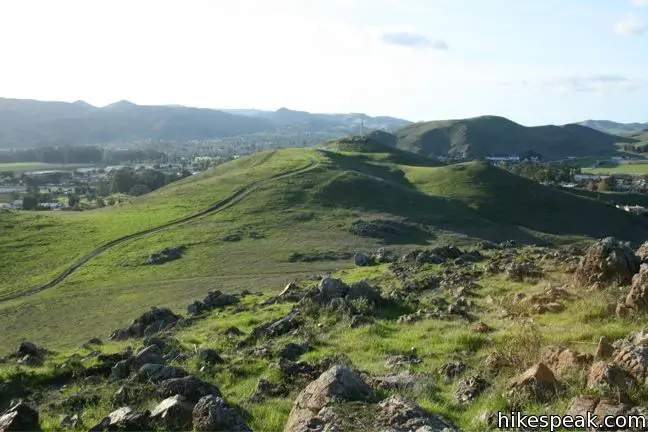
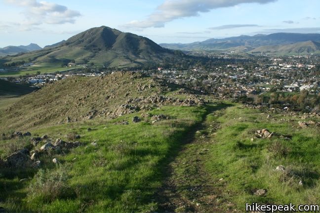
Begin hiking south up the dirt single track along the left side of a draw in the hillside. After 1/8 of a mile, pass through a cattle gate crossing the trail. Just before the gate, a footpath to the left goes to a low overlook. Continue up the grassy slope for another 1/8 of a mile to a marked junction at a saddle in the ridgeline. Turn left toward the rocky slope leading up to the high point of the park. Straight ahead, the Loop Trail continues a short distance to a meeting with a dirt road heading uphill to the right to a collection of transceiver towers. The trail heads in the other direction as well, down around the hill to a few other trailheads.
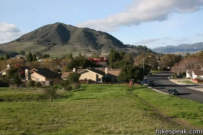
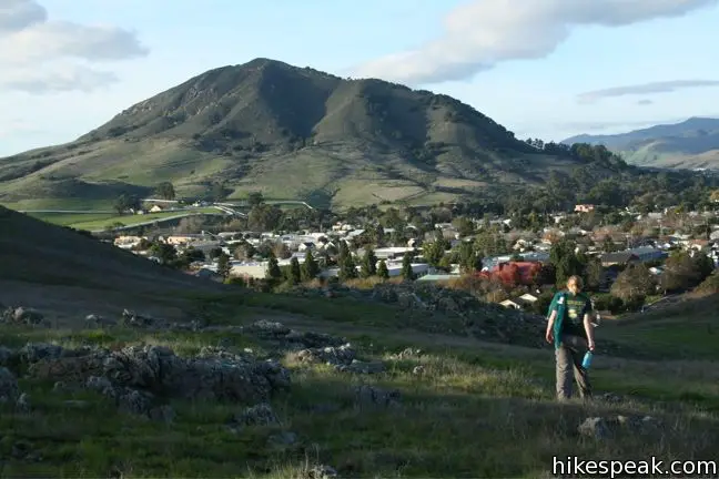
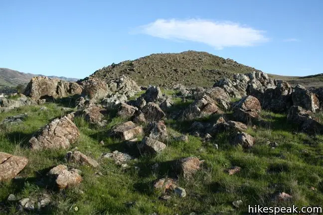
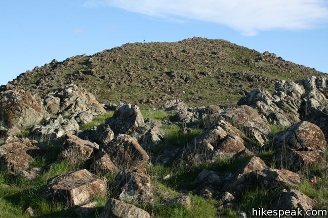
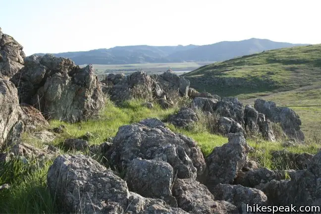
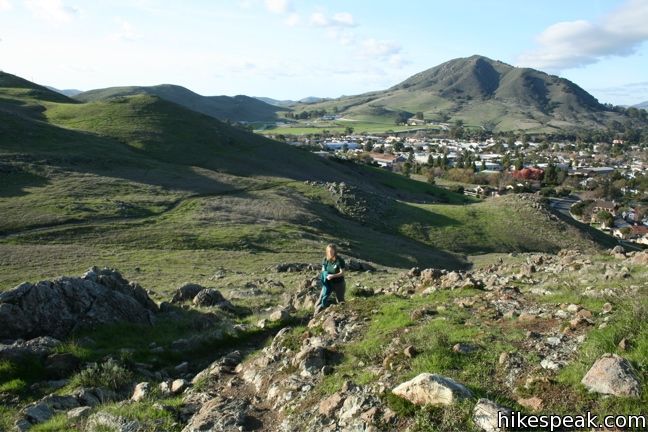
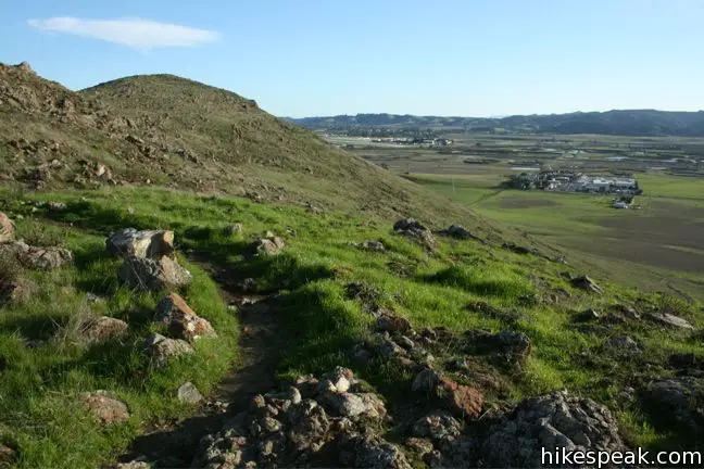
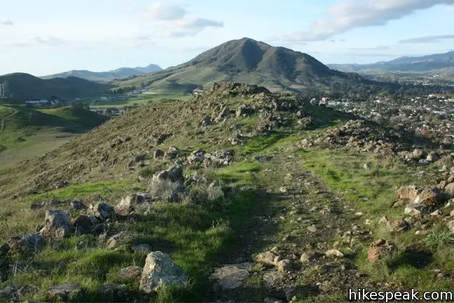
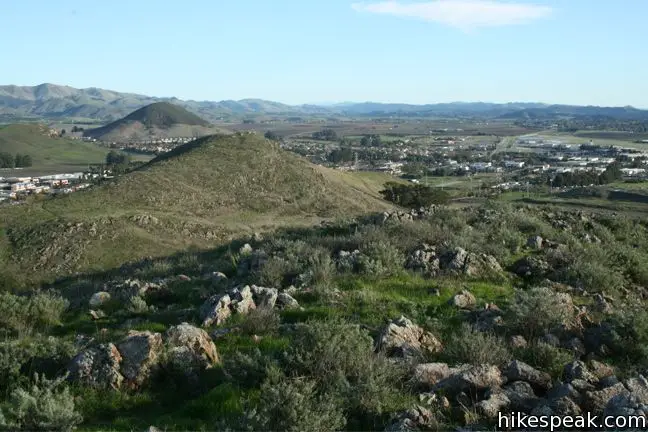
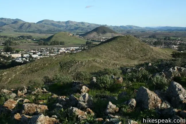
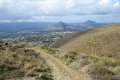
Left of the junction, the single track crosses the saddle and meets the rocky ridge. The trail angles to the right, southeast, up through the rock formations, becoming faint in places as it tackles a slope of blue-gray boulders circled by brushgrass. The views become progressively more panoramic as you climb. North of the city rises Cerro San Luis (or San Luis Mountain) and behind that is Bishop Peak. Laguna Lake and the Irish Hills are in sight to the west, and the Santa Lucia Mountains can be seen to the east and south, framing the Edna Valley. Eventually, the easternmost Morro, Islay Hill, becomes visible as well.

The craggy rocks on the windswept slopes of the South Hills create a picturesque foreground for hikers on this trail. Few plant species can grow in the serpentine soil covering the South Hills. The grasses and wildflowers that are able to grow here are uniquely suited for the tough environment, and thrive absent the competition of gamier species. The grassy tree-less terrain provides open views of the surrounding city and peaks.
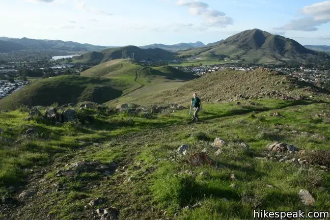
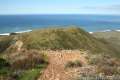
A quarter mile from the junction is a false summit. Fortunately, the trail continues along the ridge for another quarter mile to an even higher point at the top of the South Hills. The grassy summit provides sweeping 360-degree views. Take in the impressive sights before returning the way your came.
This 1.5-mile hike to the 580-foot top of the South Hills is a brief and enjoyable excursion just blocks from downtown San Luis Obispo. Dogs are welcome on the trail, and no fee or permit is required, so get out and enjoy.
Directions to the Trailhead
- From Highway 101, exit on Madonna Road and head northeast for 1/4 of a mile to Higuera Street.
- Turn left and continue north for one black to South Street.
- Turn right on South Street.
- Go 1/3 of a mile and make the second right onto Exposition Drive.
- Continue a quarter mile to the Woodridge Trailhead on the right.
- The trailhead is just after an intersection with Corrida Drive, where Exposition Drive becomes Woodbridge Street.
- Roadside parking is available.
Trailhead Location
Trailhead address: 385 Woodbridge Street, San Luis Obispo, CA 93401
Trailhead coordinates: 35.2666, -120.66434 (35° 15′ 59.75″N 120° 39′ 51.6″W)
View San Luis Obispo in a larger map
Or view a regional map of surrounding Central Coast trails and campgrounds.


 | Islay Hill This 1.8-mile round trip hike climbs 550 feet to the top of San Luis Obispo's easternmost Morro. |
 | Terrace Hill This 0.55-mile hike tours a flattened mountaintop in the city of San Luis Obispo that hosts panoramic views of the surroundings. |
 | Murray Hill via Sydney Street Trail This 2.8-mile round trip hike rapidly ascends 1,275 feet up a rugged trail to a stone seating area at a summit with panoramic views. |
 | Cerro San Luis This 4-mile hike summits one of the Nine Sisters just west of downtown San Luis Obispo, delivering panoramic views. |
 | Cerro San Luis from Laguna Lake Park This 5.7-mile hike reaches the summit from a nearby park, enjoying even more San Luis Obispo views. |
 | "M" Trail This extensions off the trail up Cerro San Luis makes its own 1.9-mile round trip hike to the large white "M" installed halfway up the east side of the mountain. |
 | Lemon Grove Trail This 2.2-mile loop visits a historical lemon grove on the eastern slopes of Cerro San Luis. |
 | Lemon Grove & "M" Trails Loop This 2.4-mile hike uses all of the "M" Trail and part of Lemon Grove Loop Trail for a scenic circuit on the east side of Cerro San Luis. |
| Cerro San Luis from Laguna Lake Park This 5.7-mile hike ascends to the summit from a nearby park. |
 | Bishop Peak This 3.5-mile hike ascends 950 feet to highest summit in the Nine Sisters, offering excellent views of San Luis Obispo and the surrounding Morros. |
 | Felsman Loop Trail This 2.7-mile loop crosses oak, sagebrush, and grass-covered slopes around the base of Bishop Peak, providing excellent views of that notable rocky summit and its San Luis Obispo surroundings. |
 | Morro View This 3.15-mile hike in the Irish Hills Natural Reserve delivers panoramic views over Los Osos Valley and the full chain of Morros. |
 | Froom Creek Trail This 3-mile loop explores a canyon on the east side of the Irish Hills, ascending 500 feet to a nice view over Laguna Lake, Cerro San Luis, and Bishop Peak. |
 | Reservoir Canyon This 5.35-mile hike ascends 1,350 feet past a waterfall and a collection of junk sculptures to a treeless summit overlooking San Luis Obispo. |
 | Poly Canyon Design Village This 2.5-mile hike visits an experimental architectural village designed by Cal Poly students at the base of the Santa Lucia Mountains. |
 | More hikes in San Luis Obispo Explore other trails around San Luis Obispo including Morro Bay State Park and Montaña de Oro State Park. |
Common Questions about South Hills Ridge Trail in San Luis Obispo
- Is the trail open?
- Yes. You should expect to find that South Hills Open Space Ridge Trail is open. There are no recent reports of trail closures. If you discover that the trail is closed, please help your fellow hikers by reporting a closure.
- Is this trail free to access?
- Yes, South Hills Open Space Ridge Trail is free to access. No entrance fee, pass, or permit is required. If you discover that access rules have changed, please provide feedback on your experience.
- How much time does this hike take?
- It takes approximately 45 minutes to hike South Hills Open Space Ridge Trail. Individual hiking times vary. Add extra time for breaks and taking in the views.
- How long is this hike?
- The hike to South Hills Open Space Ridge Trail is a 1.5 mile out and back with 450 feet of elevation change.
- Are dogs allowed on this trail?
- Yes, dogs are allowed on South Hills Open Space Ridge Trail. The trail is open to hikers, dogs.
- Does this trail go to a summit?
- Yes, South Hills Open Space Ridge Trail reaches a summit with panoramic views.
- Where is the trailhead located?
- The trailhead for South Hills Open Space Ridge Trail is located in San Luis Obispo, CA.
Trailhead Address:
385 Woodbridge Street
San Luis Obispo, CA 93401
Trailhead Coordinates:
35.2666, -120.66434 - What are the driving directions to the start of the hike?
To get to the trailhead: From Highway 101, exit on Madonna Road and head northeast for 1/4 of a mile to Higuera Street. Turn left and continue north for one black to South Street. Turn right on South Street. Go 1/3 of a mile and make the second right onto Exposition Drive. Continue a quarter mile to the Woodridge Trailhead on the right. The trailhead is just after an intersection with Corrida Drive, where Exposition Drive becomes Woodbridge Street. Roadside parking is available.
View custom Google Maps directions from your current location.
- Are there other trails near South Hills Open Space Ridge Trail?
- Yes, you can find other nearby hikes using the Hikespeak Hike Finder Map.

There is another trailhead to access this trail at 2695 Meadow St. This is called the Northside Trail access to the South Hills Open Space. It can be reached by walking down the extension of Mitchell Rd that is signed “private drive”. You will see a trail sign as you walk part way down.
Handy to know…thanks!
When will South Hills Trail be useable again now that the fire ? has closed it?