Hikes in San Luis Obispo County
San Luis Obispo, California is becoming known as the happiest place in America. The beautiful beaches, bustling downtown, and bountiful wineries are often credited with inspiring the mirth, but the great hiking trails must have something to do with it too.
Highlights of San Luis Obispo County


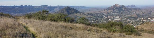
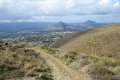
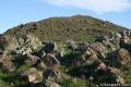
San Luis Obispo is famous for the Nine Sisters, or Morros, a stunning string of volcanic peaks stretching from Morro Bay across San Luis Obispo. Five of the Nine Sisters have hiking trails: Black Hill, Cerro Cabrillo, Bishop Peak, Cerro San Luis, and Islay Hill (and you can take a walk up the beach to Morro Rock). Bishop Peak is the tallest of the Morros at 1,559 feet, and is a must-do hike for anyone in the region.
You will discover several other places to hike around San Luis Obispo, including Montaña de Oro State Park and Morro Bay State Park, two gems on the California coast.
San Luis Obispo County Hiking
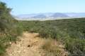
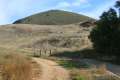
These trails around San Luis Obispo, California are listed roughly from west to east and north to south. The table may also be sorted alphabetically or by distance to help you pick your next hike. Each hike links to its own report complete with photos, GPS maps, elevation profile, driving directions, and any other information needed to locate and enjoy these hikes. You can also view hikes around San Luis Obispo County on the Hike Finder Map.
Trail | Description | Distance | Location |
|---|---|---|---|
 075 075 | Piedras Blancas This out and back hike ventures up the coast from the Piedras Blancas Elephant Seal Rookery to Piedras Blancas Light Station. | 3.2 - 4.2 miles 25 feet | 35.664401, -121.262713 |
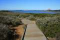
 085 085 | Moonstone Beach Boardwalk This out and back hike crosses a boardwalk along a charming Cambria beach in Hearst San Simeon State Park. | 2.85 miles 40 feet | 35.569, -121.105867 |
 086 086 | Bluff Trail (in Fiscalini Ranch Preserve) This easy stroll crosses beautiful undeveloped coastline at the center of Cambria. | 1.85 - 1.9 miles 50 - 80 feet | 35.55613, -121.1024 |
 088 088 | Headlands Trail This gradual lollipop loop in Harmony Headlands State Park crosses a coastal valley to reach picturesque ocean bluffs on the rugged coast between Cayucos and Cambria. | 4.5 miles 135 feet | 35.477783, -120.992263 |
 090 090 | Cerro Alto This semi-loop bags the 2,624-foot summit of Cerro Alto, plus a scenic ridge south of the peak. | 5.35 miles 1,600 feet | 35.424271, -120.738988 |
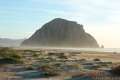 095 095 | Morro Rock via Morro Strand Trail This level stroll starts from Cloisters Park and crosses Morro Strand State Beach to reach Morro Rock. | 1 - 3.5 miles 25 feet | 35.38898, -120.860108 |
 098 098 | Black Hill This out and back hike to the summit of one of the Nine Sisters reaches 360-degree views over Morro Bay. | 0.6 miles 175 feet | 35.358059, -120.833378 |
 100 100 | Turtle Rock This easy out and back hike reaches a short rise between Black Hill and Cerro Cabrillo in Morro Bay State Park. | 2.1 miles 200 feet | 35.34652, -120.8252 |
 115 115 | Cerro Cabrillo This tough out and back hike summits the highest mountain in Morro Bay State Park, a 911-foot member of the Nine Sisters. | 2.5 miles 900 feet | 35.34652, -120.8252 |
 120 120 | Portola Point This loop explores a short hill in Morro Bay State Park just east of Morro Estuary with an easy-to-reach ocean overlook. | 2 miles 315 feet | 35.34652, -120.8252 |
 122 122 | Chumash & Crespi Trails Loop This hike in Morro Bay State Park visits an oak grove and bay views by combining Chumash Trail, Crespi Trail, and Hutash Trail. | 2.9 miles 420 feet | 35.3315, -120.81645 |
 125 125 | Eagle Rock Nature Trail This loop in El Chorro Regional Park climbs to Eagle Rock Viewpoint for an overview of the valley between San Luis Obispo and Morro Bay. | 2.4 miles 450 feet | 35.33567, -120.727234 |
 130 130 | Elfin Forest Natural Reserve This easy boardwalk loop explores a pygmy forest on the edge of Morro Bay. | 1 mile 80 feet | 35.331678, -120.82539 |
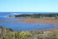
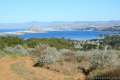 135 135 | Morro Dunes Ecological Reserve This lollipop loop serves up panoramic views over Morro Bay as it climbs from Los Osos to Montaña de Oro State Park. | 2.6 miles 800 feet | 35.308454, -120.843157 |
 140 140 | Los Osos Oaks State Natural Reserve This short hikes explores a pygmy forest of coast live oaks, providing a shady level stroll on overlapping loops. | 0.75 - 1.5 miles 25 feet | 35.306274, -120.813509 |
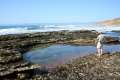 145 145 | Hazard Canyon Reef This short hike in Montaña de Oro State Park descends an oceanfront ravine to a rocky shoreline graced with engaging tide pools. | 1 mile 100 feet | 35.285512, -120.881105 |
 145 145 | Hazard Peak via Bloody Nose Trail, Hiedra Trail, and Hazard Peak Trail This hike rises through a eucalyptus grove and views of Morro Bay to a panoramic summit in Montaña de Oro State Park. | 5.55 miles 950 feet | 35.2854, -120.8801 |
 148 148 | South Dune Trail – Bloody Nose Trail – Hiedra Trail – Hazard Peak Trail Loop This four-trail loop through dunes and eucalyptus trees rises to lovely coastal views. | 2.67 miles 310 feet | 35.277106, -120.884546 |
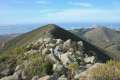
 150 150 | Hazard Peak Trail This out and back hike in Montaña de Oro State Park ascends coastal ridges to a 1,076-foot summit with panoramic views that include a dynamic perspective of Morro Bay. | 6 miles 950 feet | 35.277106, -120.884546 |
 155 155 | Hazard Peak - Islay Creek Loop This loop in Montaña de Oro State Park continues beyond Hazard Peak deeper into the Irish Hills before circling back to the coast on Islay Creek Trail. | 9.2 miles 1,00 feet | 35.277106, -120.884546 |
 160 160 | Islay Creek Trail This easy out and back hike in Montaña de Oro State Park follows a wide trail up a coastal canyon flanked by thousand-foot peaks, passing a small waterfall to reach an abandoned barn. | 6 miles 300 feet | 35.276412, -120.885504 |
 164 164 | Reservoir Flats Trail This loop delivers fine ocean and canyon views as it explores the bottom of Islay Creek Canyon in Montaña de Oro State Park. | 2 miles 200 feet | 35.273872, -120.88553 |
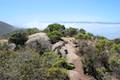
 167 167 | Oats Peak This out and back hike reaches a panoramic summit that looks down over Montaña de Oro State Park. | 10.8 miles 1,325 feet | 35.273872, -120.88553 |
 170 170 | Valencia Peak This out and back hike summits a 1,347-foot peak with panoramic views over Montaña de Oro State Park. | 4.5 miles 1,275 feet | 35.272858, -120.888755 |
 180 180 | Bluff Trail (in Montaña de Oro State Park) This out and back hike of around three miles tours tide pools, beaches, and impressive cliffs along a picturesque coastline. | 1 - 5 miles 90 - 140 feet | 35.2728, -120.8887 |
 182 182 | Rattlesnake Flats Trail – Badger Trail – Bluff Trail Loop This loop offers a twist on the Bluff Trail, going along and just above the coast of Montaña de Oro State Park. | 1.65 miles 150 feet | 35.272858, -120.888755 |
 188 188 | Coon Creek Trail This out and back hike ventures up a coastal canyon at the south end of Montaña de Oro State Park. | 5 miles 250 feet | 35.257927, -120.886988 |
 190 190 | Point Buchon This short scenic loop or longer out-and-back hike explores the beautiful coastline south of Montaña de Oro State Park. | 1.33 - 6.8 miles 75 feet | 35.257964, -120.887483 |
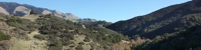
 192 192 | East Cuesta Ridge This wide dirt road offers out and back hikes to the tops of Mount Lowe and Lopez Canyon Trail, offering ocean views over San Luis Obispo and inland views over an evergreen wilderness. | 8.4 - 10.2 miles 1,015 - 1,075 feet | 35.34995, -120.63175 |
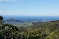 193 193 | Cuesta Ridge Botanical Area This out and back hike crosses a ridge in the Santa Lucia Mountains with panoramic views over San Luis Obispo, ascending to a grove of Sargent cypress in a botanical area in Los Padres National Forest. | 6 miles 950 feet | 35.347125, -120.63045 |
 195 195 | Stenner Creek Trail to the Eucs This out and back hike goes up Stenner Creek Canyon past a small waterfall and views of Bishop Peak to a collection of freeride bike trails called the Eucs. | 3.7 miles 650 feet | 35.33016, -120.6631 |
 196 196 | Stenner Creek Trail – Red Dog Trail – Poly Canyon Road Loop This loop goes beyond the Eucs atop Stenner Creek Trail to explore grass-covered slopes at the base of the Santa Lucia Mountains. | 4.25 miles 550 feet | 35.33016, -120.6631 |
 200 200 | Poly Canyon Design Village This lollipop loop hike visits an architectural village designed by Cal Poly students at the base of the Santa Lucia Mountains. | 2.5 miles 300 feet | 35.30445, -120.65845 |
 208 208 | Felsman Loop Trail This loop crosses oak, sagebrush, and grass-covered slopes around the base of Bishop Peak, providing excellent views of that notable rocky summit and its San Luis Obispo surroundings. | 2.7 miles 525 feet | 35.30433, -120.685438 |
 210 210 | Bishop Peak This out and back hike summits the tallest of the Nine Sisters for excellent views over San Luis Obispo. | 3.5 miles 950 feet | 35.30433, -120.685438 |
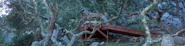
 220 220 | Reservoir Canyon Trail This steep hike passes a waterfall and a collection of junk sculptures en route to a treeless summit overlooking San Luis Obispo. | 5.35 miles 1,350 feet | 35.29097, -120.6280 |
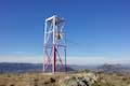 221 221 | Reservoir Canyon Summit Trail This hike ascends to a point on the northwest end of the ridge above Reservoir Canyon, presenting panoramic views over San Luis Obispo from the base of an old tower with a bell that can be rung with a thrown pebble. | 4.1 miles 1,175 feet | 35.29097, -120.6280 |
 222 222 | Reservoir Canyon Trail - Summit Trail Loop This loop ventures up Reservoir Canyon Trail to the summit viewpoint, crosses Ridge Trail to the bell tower, and descends Summit Trail back into Reservoir Canyon. | 5.6 miles 1,350 feet | 35.29097, -120.6280 |
 224 224 | Creek Bypass Trail Loop This short hike connects Summit Trail and Reservoir Canyon Trail with a short trail offering broad canyon views. | 1 mile 150 feet | 35.29097, -120.6280 |
 225 225 | Rinconada Trail & Bell Mountain This hike near Santa Margarita ascends past an old mercury mine and bucolic views to a grassy saddle with a sweeping perspective over the Santa Lucia Mountains. Extend the outing to a nearby summit for even grander vistas. | 3 - 3.25 miles 625 - 865 feet | 35.28995, -120.47485 |
 230 230 | Lemon Grove Loop Trail This easy loop visits a historic lemon grove on the eastern slopes of Cerro San Luis. | 2.2 miles 300 feet | 35.2749, -120.67237 |
 235 235 | Lemon Grove & "M" Trails Loop This outing uses all of the "M" Trail and part of Lemon Grove Loop Trail for a scenic circuit on the east side of Cerro San Luis. | 2.4 miles 560 feet | 35.2749, -120.67237 |
 240 240 | Cerro San Luis This hike summits one of the Nine Sisters just west of downtown San Luis Obispo. | 4 - 5 miles 1,100 feet | 35.2749, -120.67237 |
 250 250 | "M" Trail This spur off the trail up Cerro San Luis leads to a large white "M" installed halfway up the east side of the mountain. | 1.9 miles 560 feet | 35.274897, -120.672369 |
 255 255 | Cerro San Luis from Laguna Lake Park This out and back hike summits one of the Nine Sisters just west of downtown San Luis Obispo. | 5.7 miles 1,150 feet | 35.26521, -120.68274 |
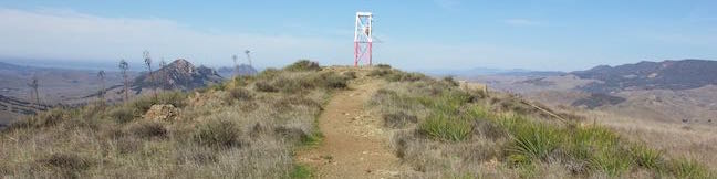
 260 260 | Sydney Street Trail to Murray Hill (Unnamed Hill) This out and back hike climbs a steep rugged trail to a stone seating area at a panoramic summit. | 2.8 miles 1,275 feet | 35.27307, -120.641322 |
 267 267 | Terrace Hill This hike tours a flattened mountaintop in the city of San Luis Obispo that hosts panoramic views of the surroundings. | 0.55 miles 110 feet | 35.2725, -120.64886 |
 270 270 | South Hills Ridge Trail This out and back hike visits the top of a cluster of hills near downtown San Luis Obispo, offering fine views over the city and surroundings. | 1.5 miles 425 feet | 35.2666, -120.66434 |
 280 280 | Morro View in the Irish Hills This out and back hike in Irish Hills Natural Reserve delivers panoramic views over Los Osos Valley and the full chain of Morros. | 3.15 miles 850 feet | 35.262195, -120.71195 |
 290 290 | Froom Creek Trail Loop in the Irish Hills This loop explores a canyon on the east side of the Irish Hills before ascending to a nice view over Laguna Lake, Cerro San Luis, and Bishop Peak. | 3 miles 500 feet | 35.25431, -120.69525 |
 295 295 | Old Prospector Trail Loop in the Irish Hills This lollipop loop hike ventures up a rugged ravine off Froom Canyon to the ruins of an old mine. | 3.4 - 4.4 miles 650 feet | 35.25431, -120.69525 |
 300 300 | Islay Hill This out and back hike summits San Luis Obispo's easternmost Morro. | 1.8 miles 550 feet | 35.243296, -120.62713 |
 308 308 | Johnson Ranch - Irish Hills Connector Trail This scenic point-to-point hike connects Johnson Ranch Open Space with Irish Hills Natural Reserve. | 5 - 10 miles 575 feet | 35.223448, -120.693313 |
 310 310 | Johnson Ranch Loop This loop explores rolling hills in a grassy open space just south of San Luis Obispo. | 2.5 - 3.7 miles 200 feet | 35.223448, -120.693313 |
 315 315 | Hi Mountain Trail This short trail goes through many phases as it explores the Santa Lucia Mountains east of Arroyo Grande and combines with part of Hi Mountain Road to form a loop. | 3.25 miles 575 feet | 35.2075, -120.38237 |
 320 320 | Bob Jones Bike Trail This easy round trip hike or ride follows San Luis Obispo Creek to Avila Beach. | 5 miles 50 feet | 35.185651, -120.703016 |
 330 330 | Sycamore Crest Trail This out and back hike ascends the north slope of Ontario Hill to a scenic ocean view perch. | 1.75 - 3.25 miles 575 feet | 35.186, -120.7146 |
 340 340 | Shell Beach Bluff Trail - Ontario Ridge Trail This loop explores the coast between Shell Beach and Avila Beach, on and below a 700-foot ridge. | 2.8 miles 675 feet | 35.1758, -120.7192 |
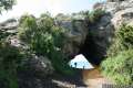 350 350 | Cave Landing This short out and back hike descends to a natural rock bridge at the end of a headland east of Avila Beach. | 0.5 miles 100 feet | 35.1758, -120.7192 |
 355 355 | Point San Luis Lighthouse via Pecho Coast Trail This docent-led hike crosses scenic coastal bluffs to reach the historic lighthouse on Point San Luis. | 3.5 miles 300 feet | 35.174146, -120.756013 |
 380 380 | Oso Flaco Lake Trail This hike takes a boardwalk over a coastal lake and across sand dunes to an out-of-the-way beach. | 2 miles or more 25 feet | 35.0288, -120.6171 |
San Luis Obispo County Camping
San Luis Obispo also has places to cam, including this pair of developed campground.
 | Cerro Alto Campground This cozy 22-site campground is the starting point the hike to Cerro Alto and a perfect place to tent camp in the Los Padres National Forest between Morro Bay and Atascadero. |
 | Islay Creek Campground This 50-site campground is located at the heart of Montaña de Oro State Park in Islay Creek Canyon near the coast and several park trails. |
Or explore hikes around San Luis Obispo County on the Hike Finder Map