Hikes in the San Gabriel Mountains
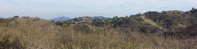
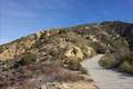
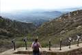
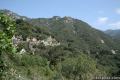
The San Gabriel Mountains are a monumental mountain range running west to east across Los Angeles County through an area north of cities like Glendale, Pasadena, Arcadia, Azusa, and Claremont. Despite the proximity to Los Angeles, these mountains hold many wild and beautiful peaks and canyon. Though it is close to LA, in some ways the San Gabriel Mountains couldn’t be farther away. Escape to great trails in the San Gabriels!
Highlights of the San Gabriel Mountains


The San Gabriel Mountains
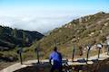
On October 10th, 2014, San Gabriel Mountains National Monument was created to give special designation to this impressive mountain range and protect its sublime waterfalls, soaring summits, and sylvan forests. The new monument covers 342,177 acres of Angeles National Forest as well as 4,002 acres of San Bernardino National Forest on the east end of the range. This 540-square mile park is a playground for the outdoorsy, with great hiking trails and campgrounds.
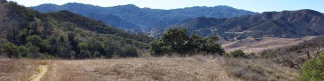
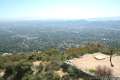
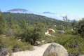
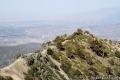
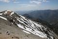
The highest point in the range is Mount Baldy, at 10,064 feet. Other notable summits include Mount Baden-Powell, Mount Waterman, and Strawberry Peak.
If you are interested in camping, you’ll find many options in the San Gabriel Mountains, including Buckhorn Campground, Coldbrook Campground, Horse Flats Campground, and Manker Flats Campground.
A National Forest Adventure Pass has been a required permit to visit many trails beginning in Angeles National Forest. Due to legal challenges, the Adventure Pass is no longer necessary in many areas (and could disappear completely). The pass can still be be purchased for $5 per day or $30 per year. The pass can be used in other national forests in Southern California as well. Passes may be purchased from ranger stations within the park, at various local retailers, and online. Those without a pass may still enjoy several free entry points located inside and outside the national forest boundary. An America the Beautiful National Parks and Federal Recreational Lands Pass can also be used in lieu of an Adventure Pass.
San Gabriel Mountains Hiking
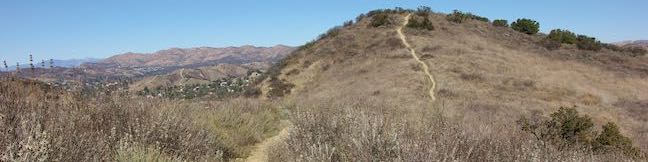
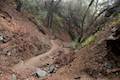
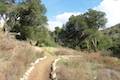
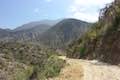
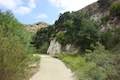
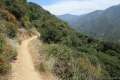
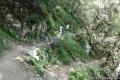
This collection of trails in the San Gabriel Mountains lists the hikes from west to east. The table may also be sorted alphabetically or by distance to help you pick your next hike. A search feature can be used to quickly isolate the hike you are looking for. Each trail links to its own report complete with photos, GPS maps, elevation profile, directions, and all the other information needed to locate and enjoy these hikes. You can also view hikes around the San Gabriel Mountains on the Hike Finder Map.
Trail | Description | Distance | Location |
|---|---|---|---|
 038 038 | Los Pinetos Waterfall This out and back hike in Placerita Canyon Natural Area follows Canyon Trail to the ruins of Walker Ranch and Waterfall Trail to an elusive falls in a sylvan canyon. | 5.33 miles 560 feet | 34.377866, -118.467675 |
 040 040 | Ecology Trail This lollipop loop in Placerita Canyon Natural Area will introduce you to numerous local plants along with views of Placerita Canyon. | 0.65 miles 100 feet | 34.377866, -118.467675 |
 525 525 | Trail Canyon Falls This hike ascends a mountain-framed canyon to a 30-foot beauty on the east side of the range. | 4 miles 700 feet | 34.30533, -118.25536 |
 530 530 | Gould Mesa Trail Camp via Gould Mesa Road This road descends from Angeles Crest Highway to Gabrielino Trail alongside Gould Mesa Trail Camp, a hike-in campground in a canyon in Angeles National Forest. | 2.4 miles 525 feet | 34.22295, -118.1906 |
 531 531 | Gould Mesa Trail Camp via Gabrielino Trail This hike follows the Arroyo Seco, a mountains stream, up to a trail camp just inside Angeles National Forest. | 5.1 miles 300 feet | 34.1943, -118.168 |
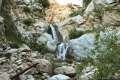
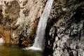 535 535 | Switzer Falls This out and back hike starts out above and finishes below a 50-foot tall waterfall. | 4.5 miles 650 feet | 34.26624, -118.1457 |
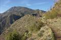
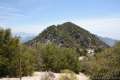
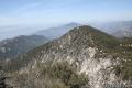
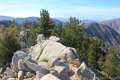
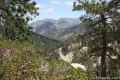
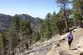
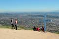
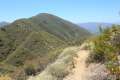
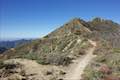 537 537 | Colby Canyon Trail to Josephine Peak This out and back hike ascends an infrequently visited canyon off Angeles Crest Highway up to a saddle below Strawberry Peak and then to a scenic summit in the front range of the San Gabriel Mountains with 360-degree over Big Tujunga Canyon and cities to the south. | 8.7 miles 2,050 feet | 34.2696, -118.1407 |
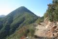
 537 537 | Strawberry Peak This out and hike to the highest summit in the front range of the San Gabriel Mountains starts out gradual and becomes steep, presenting grand views of surrounding mountains and the cities below. | 7.5 miles 1510 feet | 34.2581, -118.1049 |
 538 538 | Strawberry Meadow This though hike or out and back hike goes around Strawberry Peak to a remote and scenic flat below a massive cliff on the north side of the mountain, offering views of Big Tujunga Canyon and surrounding peaks along the way. | 9 - 11 miles 800 - 1,600 feet | 34.2907, -118.10789 |
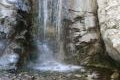 540 540 | Millard Falls This out and back hike visits a 50-foot waterfall up one of the most scenic canyons in the range. | 1 mile 150 feet | 34.2162, -118.1463 |
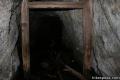 545 545 | Dawn Mine This out and back hike leads past Millard Falls to an old gold mine. | 6 miles 1,300 feet | 34.2162, -118.1463 |
 550 550 | San Gabriel Peak from Mount Disappointment Road This out and back hike reaches a peak with great views of the San Gabriels, and you can summit nearby Mount Disappointment for an extra half mile. | 4 - 4.5 miles 1,400 feet | 34.25455, -118.1021 |
 553 553 | San Gabriel Peak from Mount Lowe Road This out and back hike reaches a peak with great views of the San Gabriels, and you can summit nearby Mount Disappointment for an extra half mile. | 3.2 - 3.7 miles 1,050 feet | 34.2393, -118.0934 |
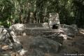
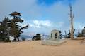
 557 557 | Inspiration Point & Mount Lowe Trail Camp This out and back hike descends Mount Lowe Road into the San Gabriel Mountains to a historic scenic overlook and a trail camp built on interesting ruins. | 7.25 miles 900 feet | 34.2393, -118.0934 |
 565 565 | Cape of Good Hope via Mount Lowe Road & Sunset Ridge Trail This pair of trails combine for a hike to a historic viewpoint called Cape of Good Hope. Follow the old route of Mount Lowe Railway to the ruins on Echo Mountain to extend the hike by two miles round. | 5.2 - 7.5 miles 1,425 feet | 34.2148, -118.1476 |
 570 570 | Echo Mountain via Sam Merrill Trail This out and back hike visits a historic railway and ruins from a century old resort overlooking Pasadena. | 5.8 miles 1,400 feet | 34.20405, -118.1306 |
 573 573 | Inspiration Point via Castle Canyon Trail This trail ascends from the ruins on Echo Mountain to a historic viewpoint that still offers hike-worthy panoramas. See more on a loop back to Echo Mountain that visits Mount Lowe Trail Camp, Cape of Good Hope, and other landmarks on Mount Lowe Railway. | 11.45 - 11.7 miles 2,440 - 2,715 feet | 34.20405, -118.1306 |
 575 575 | Rubio Canyon Trail This out and back hike ventures into a rustic canyon to a double waterfall. | 1.3 miles 350 feet | 34.203038, -118.122354 |
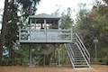 577 577 | Henninger Flats via Mount Wilson Toll Road This out and back hike ascends to a pine-covered landing with a trail camp, tree nursery, lookout tower, and visitor center operated by the Los Angeles County Fire Department. | 6 - 8.7 miles 1,325 - 1,700 feet | 34.191714, -118.105506 |
 580 580 | Eaton Canyon Falls This out and back hike up Eaton Wash reaches a narrow stretch of Eaton Canyon containing a pleasant 40-foot waterfall. | 3.5 miles 375 feet | 34.17832, -118.09663 |
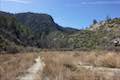
 585 585 | Vetter Mountain This out and back hike ascends from Charlton Flats Picnic Area to Vetter Mountain, where the site of an old fire lookout tower offers exceptional 360-degree views. | 3.8 - 4.4 miles 525 - 650 feet | 34.296502, -118.006956 |
 588 588 | Mount Hillyer This 6,215-foot summit can be reach from two trailheads, including the nearest starting point at Horse Flats Campground. | 3 - 6.25 miles 575 - 1,000 feet | 34.330998, -118.011882 |
 590 590 | Upper Winter Creek Trail This 2.75-mile long trail can be used to extend Santa Anita Canyon Loop or create a loop with Lower Winter Creek Trail. | 4.85 miles 1,000 feet | 34.196194, -118.02265 |
 595 595 | Hoegees Camp This out and back hike follows Lower Winter Creek Trail through a beautiful wooded canyon to a backcountry campground with fourteen first-come first-serve sites. | 4.25 miles 700 feet | 34.1955, -118.0225 |
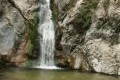
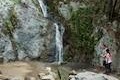
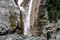
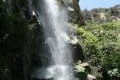 600 600 | Sturtevant Falls This out and back hike visits a 60-foot waterfall in a lush cottage-lined canyon. | 3.3 miles 400 feet | 34.1955, -118.0225 |
 605 605 | Spruce Grove Camp This out and back hike follows the canyon above Sturtevant Falls to a backcountry campground with seven first-come first-serve sites. | 8 miles 1,350 feet | 34.1955, -118.0225 |
 610 610 | Santa Anita Canyon Loop This loop visits two peaceful creeks in sylvan canyons, passing a 60-foot waterfall and plenty of beautiful wilderness. | 9.5 miles 1,800 feet | 34.1955, -118.0225 |
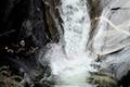 615 615 | Hermit Falls This out and back hike heads down Santa Anita Canyon's babbling creek away from Sturtevant Falls toward a 30-foot waterfall. | 2.6 miles 750 feet | 34.1955, -118.0225 |
 630 630 | Monrovia Falls This out and back hike in Monrovia Canyon Park follows an enchanting canyon up to the base of the 30-foot waterfall. | 1.6 - 3 miles 350 - 600 feet | 34.176584, -117.98952 |
 635 635 | Winston Ridge and Winston Peak This partial loop bags a summit and a scenic ridge in the high San Gabriel Mountains. | 4.85 miles 875 feet | 34.35132, -117.934352 |
 645 645 | Mount Waterman This summit can be reached on an out and back hike or a loop, going up through a pine forest to a round mountaintop. | 5.5 - 6 miles 1,265 feet | 34.350328, -117.925213 |
 646 646 | Twin Peaks & Mount Waterman This hike extends a loop over Mount Waterman by dropping across a saddle and ascending Twin Peaks East, a panoramic summit at the center of the San Gabriel Mountains. | 11.65 miles 3,640 feet | 34.350328, -117.925213 |
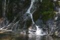 650 650 | Cooper Canyon Falls This out and back hike leaves from Buckhorn Campground and visits a short waterfall in an enchanting glen of tall pines. | 3 miles 745 feet | 34.3475, -117.9110 |
 660 660 | Fish Canyon Falls This out and back hike leaves from an active rock quarry and progresses up a beautiful canyon to a mesmerizing multi-tiered waterfall. | 4.8 miles 650 feet | 34.15676, -117.92368 |
 670 670 | Azusa Peak (and Glendora Peak) via Garcia Trail This 2 2/3-mile or 4 2/3-mile hike ascends Garcia Trail to "the A" and one or two picturesque summits along Glendora Ridge Motorway. | 4.66 1,800 feet | 34.14686, -117.890387 |
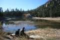 680 680 | Crystal Lake This short paved hike visits the only naturally occurring lake in the San Gabriel Mountains. | 1.33 miles 150 feet | 34.32087, -117.842642 |
 685 685 | Smith Mountain This out and back hike follows a gradual trail to a steep scramble to a 5,111 foot summit with panoramic views over the San Gabriel Mountains. | 7 miles 1,800 feet | 34.28738, -117.84267 |
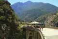 695 695 | Bridge to Nowhere This adventurous out and back hike requires several river crossings to reach an out-of-place bridge with a unique history. | 10 miles 900 feet | 34.23696, -117.765119 |
 700 700 | Heaton Flats Trail This hike starts from the same trailhead as the Bridge to Nowhere and climbs toward Iron Mountain and panoramic views. | 3.6 - 6 miles 1,000 - 2,000 feet | 34.23696, -117.765119 |
 710 710 | Mount Baden-Powell This out and back hike climbs one of the tallest summits in the San Gabriel Mountains and a monument to Lord Baden-Powell, a BSA icon and the founder of the Scout Movement. | 8.25 miles 2,834 feet | 34.372947, -117.752282 |
 725 725 | San Antonio Falls This out and back hike on a paved road visits a multi-tier waterfall below Mount Baldy. | 275 feet | 34.266172, -117.62684 |
 730 730 | Baldy Bowl - Ski Hut This out and back hike offers a steep but scenic ascent up the south side of Mt. Baldy. | 9 miles 3,900 feet | 34.266172, -117.62684 |
 735 735 | Devil’s Backbone This ridge-top trail between Baldy Notch and the summit of Mount Baldy is probably LA's greatest ridge hike, with incredible views over the San Gabriel Mountains and the Mojave Desert. | 6.6 - 13.6 miles 2,350 feet | 34.266172, -117.62684 |
 740 740 | Mount Baldy Loop This loop incorporates Devil’s Backbone and Baldy Bowl - Ski Hut Trail to reach the highest summit in the San Gabriel Mountains. | 11.3 miles 3,900 feet | 34.266172, -117.62684 |
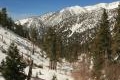 750 750 | Icehouse Canyon to Icehouse Saddle This out and back hike travels through a picturesque canyon to a saddle with panoramic views and extended hiking opportunities. | 7.2 miles 2,600 feet | 34.25018, -117.6360 |
Or explore hikes around the San Gabriel Mountains on the Hike Finder Map