Hermit Falls
in the San Gabriel Mountains

This 2.6-mile round trip hike visits a short waterfall downstream from Sturtevant Falls in the Angeles National Forest. Hermit Falls receives fewer visitors than its neighbor but is a popular swimming hole for cliff jumpers in the spring and summer. The trailhead is at 2,180 feet, while the falls are at 1,430, making this is an upside down hikes where the uphill comes at the end.
- Hermit Falls is one of the Los Angeles waterfall hikes.
Hiking to Hermit Falls
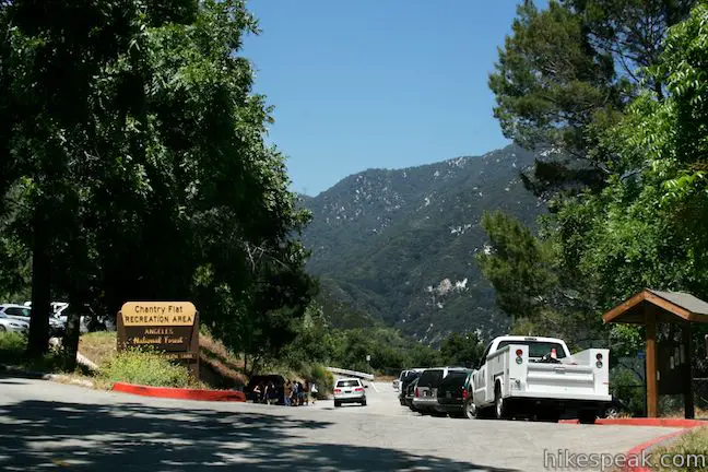
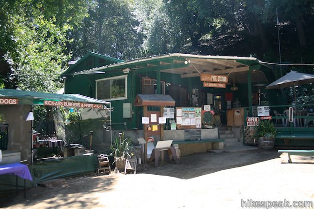
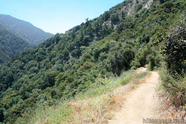
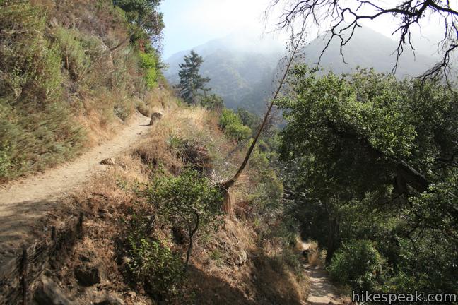
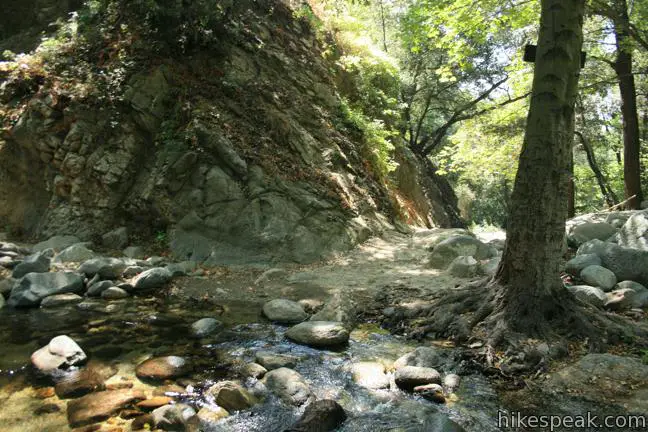
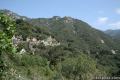
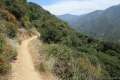
Set out from Chantry Flats in the San Gabriel Mountains and descend the paved road toward Roberts Camp. On the downhill side of a horseshoe bend in the road, 0.18 miles from the start, turn right on the dirt trail labeled First Water Trail. Follow this winding single track down into Santa Anita Canyon.
The top of First Water Trail is exposed to sun and views. The lower switchbacks find shade beneath the trees growing along the creek.
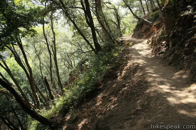
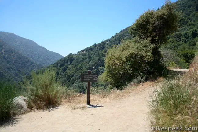
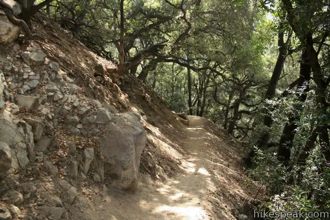
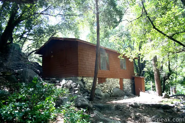
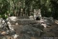
After another 0.55 miles, First Water Trail reaches the bottom of the canyon. Turn right and begin walking south past retreat cabins in the hamlet know as Roberts Camp.
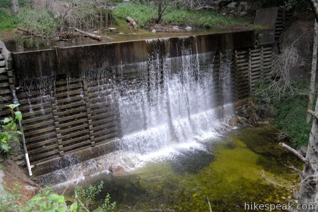
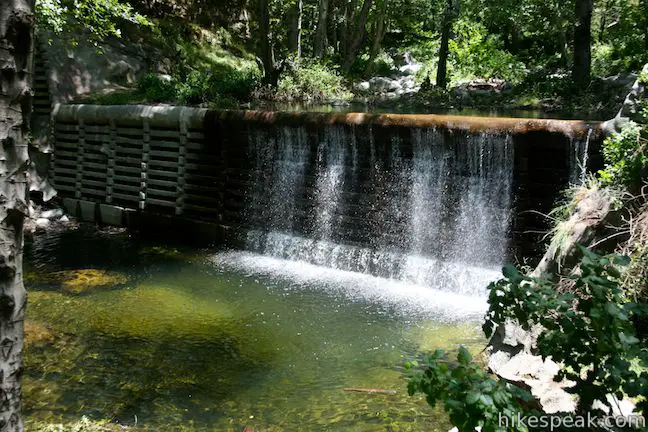
After a short distance, the trail along the bank comes to an end above a man-made dam. Rock hope to the other side of the creek and pick up the trail heading downstream. Hermit Falls is half a mile away.
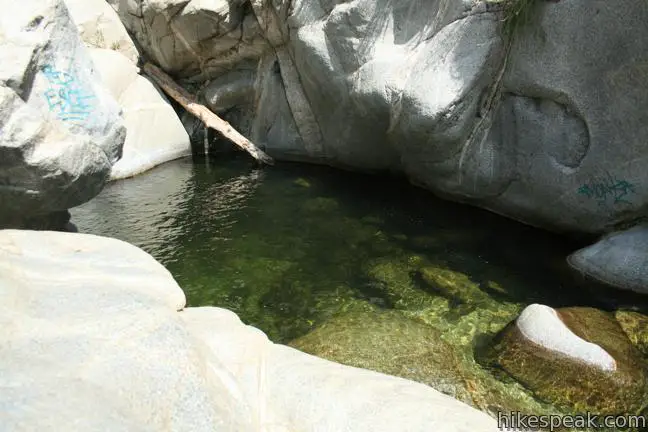
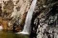
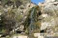
The lush canyon provides a peaceful stroll. The route crosses the babbling creek once more and climbs up the east bank, before dropping down on the pools above Hermit Falls.
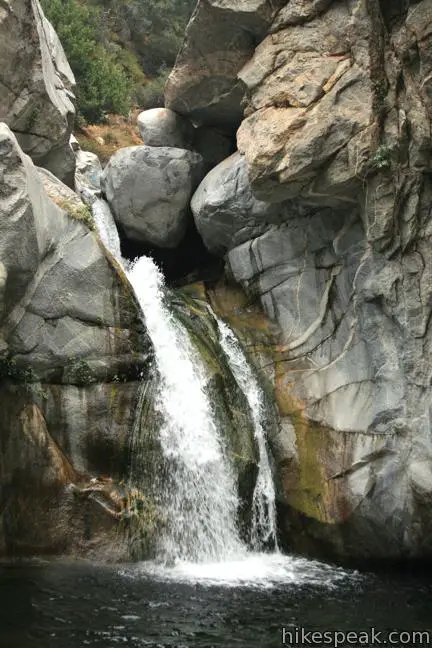
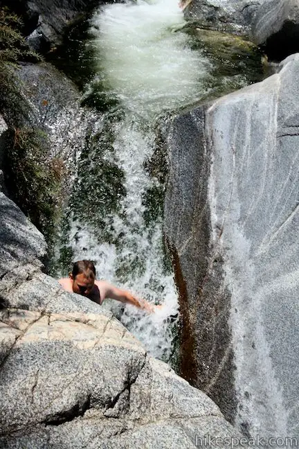
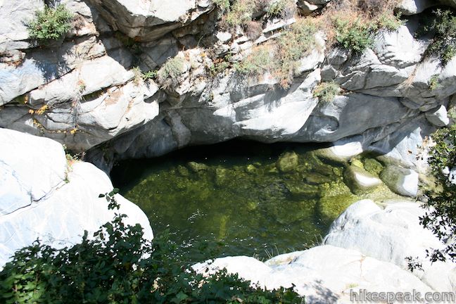
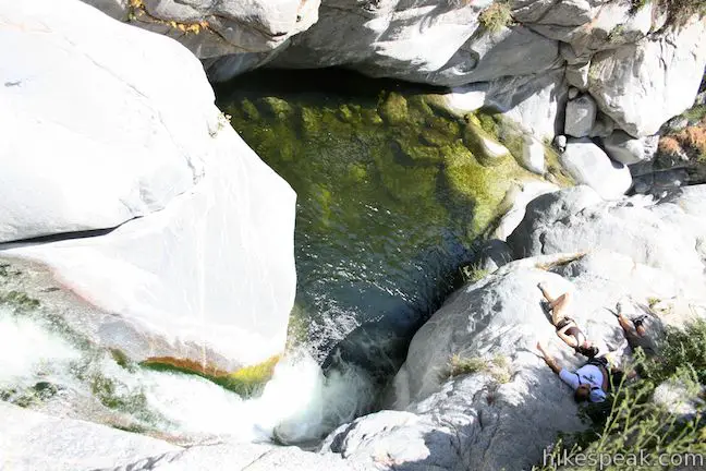
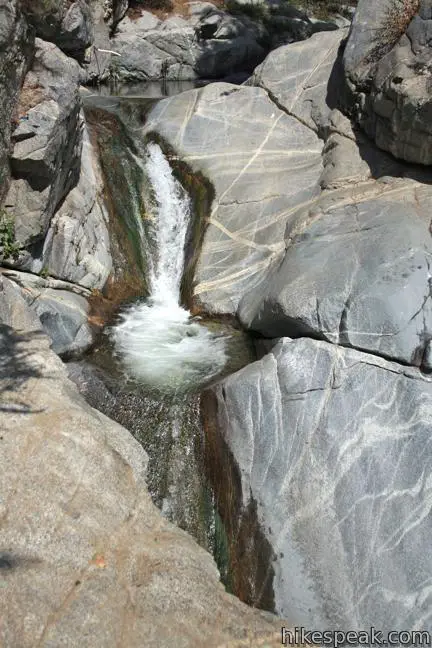
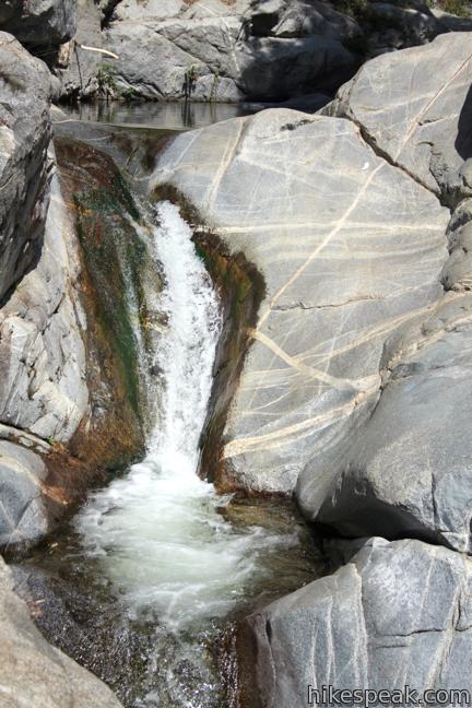
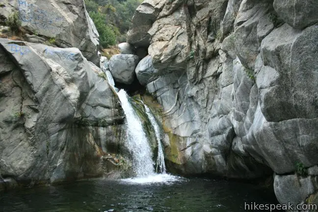
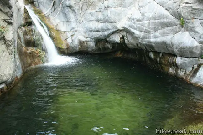
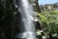
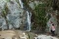
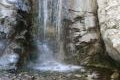
In the summer, the water above Hermit Falls makes a great swimming hole. The waterfall is bordered by ledges to jump from and flat rock perfect for sunning. When the flow is sufficient, a pair cascades above the falls form a natural water slide.
No real trail goes to the base of the falls, but those up for a technical climb can descend a steep rock face alongside the falls. Cliff jumping is another way down. While that can be dangerous, you are bound to see hikers engaging in the activity on weekends when the water is high.
In the spring, crossing the creek along the trail to Hermit Falls may require a bit of wading. The flow typically diminishes in summer months, but the trail remains pleasant in July and August when a nice shady hike and a refreshing swim are desirable.
A visit to Hermit Falls can easily be combined with a hike to Sturtevant Falls or other trails in the area (like Santa Anita Canyon Loop).
The basic directions for this hike to Hermit Falls are:
- Begin down paved Gabrielino Trail from Chantry Flats (0 miles)
- Turn right down First Water Trail (0.18 miles)
- Reach Big Santa Anita Creek, turn right, and cross to the far bank to proceed downstream(0.75 miles)
- Follow Hermit Falls Trail to the top of Hermit Falls(1.3 miles)
The directions for a hike to both Hermit Falls and Sturtevant Falls are:
- Begin down paved Gabrielino Trail from Chantry Flats (0 miles)
- Turn right down First Water Trail (0.18 miles)
- Reach Big Santa Anita Creek, turn right, and cross to the far bank to proceed downstream(0.75 miles)
- Follow Hermit Falls Trail to the top of Hermit Falls(1.3 miles)
- Hike up the canyon past First Creek Trail(1.85 miles)
- Turn right on Gabrielino Trail by a junction with Lower Winter Creek Trail(2.2 miles)
- Stay to the right when Gabrielino Trail splits(2.95 miles)
- Reach Sturtevant Falls(3.2 miles)
- Hike back down to the Lower Winter Creek Trail Junction and continue straight up the paved road(4.2 miles)
- Hike up to Chantry Flats(4.8 miles)
Dogs are welcome on the hike to Hermit Falls. Bikes are permitted to use these trails too (though this outing isn’t particularly appropriate for mountain bikes). A National Forest Adventure Pass should be displayed in vehicles parked at the Chantry Flats Trailhead.
Other waterfalls in the San Gabriel Mountains to visit include Switzer Falls, Millard Falls, Fish Canyon Falls, and Monrovia Falls.
Directions to the Trailhead
- Take the 210 Freeway to Arcadia, east of Pasadena.
- Use exit 32 for Santa Anita Avenue and head north at the end of the offramp.
- Drive 5 miles up Santa Anita Avenue, going into the mountains.
- The road ends at Chantry Flats.
Trailhead Location
Trailhead address: Chantry Flats Road, Angeles National Forest, Arcadia, CA 91006
Trailhead coordinates: 34.1955, -118.0225 (34° 11′ 43.8″N 118° 01′ 21″W)
View Santa Anita Canyon in a larger map
Or view a regional map of surrounding Los Angeles trails and campgrounds.


 | Sturtevant Falls This 3.3-mile hike visits a 60-foot waterfall and a lush cottage-lined canyon. |
 | Hoegees Camp This 4.25-mile hike follows Lower Winter Creek Trail through a beautiful wooded canyon to a backcountry campground with fourteen first-come first-serve sites. |
 | Santa Anita Canyon Loop This 9.5-mile loop visits two peaceful creeks in sylvan canyons, passing a 60-foot waterfall and plenty of beautiful wilderness. |
 | Upper Winter Creek Trail This 2.75-mile long trail can be used to extend Santa Anita Canyon Loop or create a 4.85-mile loop with Lower Winter Creek Trail. |
 | More trails in the San Gabriel Mountains Explore other destinations in the range. |
 | Monrovia Falls This 1.6-mile to 3-mile hike in Monrovia Canyon Park follows an enchanting canyon up to the base of the 30-foot waterfall. |
 | Cooper Canyon Falls This 3-mile hike leaves from Buckhorn Campground and visits a short waterfall in an enchanting glen of tall pines. |
 | Fish Canyon Falls This 4.8-mile round trip hike leaves from an active rock quarry and progresses up a beautiful canyon to a mesmerizing multi-tiered waterfall. |
 | Millard Falls This one mile hike visits a 50-foot waterfall up one of the most scenic canyons in the range. |
 | Switzer Falls This 4.5-mile hike starts out above and finishes below a 50-foot tall waterfall. |
 | Trail Canyon Falls This 4-mile hike ascends a mountain-framed canyon to a 30-foot beauty on the east side of the San Gabriel Mountains. |
 | More waterfalls around Los Angeles Explore other waterfalls in the Santa Monica and San Gabriel Mountains. |
Common Questions about Hermit Falls in the San Gabriel Mountains
- Is the trail open?
- Alert: Hike to Hermit Falls is currently marked as Closed. Please check official websites for current status.
- Do I need a permit for this hike?
- Yes. National Forest Adventure Pass.
- How much time does this hike take?
- It takes approximately 1 hour 30 minutes to hike Hike to Hermit Falls. Individual hiking times vary. Add extra time for breaks and taking in the views.
- How long is this hike?
- The hike to Hike to Hermit Falls is a 2.6 mile out and back with 750 feet of elevation change.
- Are dogs allowed on this trail?
- Yes, dogs are allowed on Hike to Hermit Falls. The trail is open to hikers, dogs, bikes.
- Will I see a waterfall on this hike?
- Yes, Hike to Hermit Falls features a waterfall.
- What mountain range is this trail in?
- Hike to Hermit Falls is located in the San Gabriel Mountains.
- Where is the trailhead located?
- The trailhead for Hike to Hermit Falls is located in Arcadia, CA.
Trailhead Address:
Chantry Flats Road
Arcadia, CA 91006
Trailhead Coordinates:
34.1955, -118.0225 - What are the driving directions to the start of the hike?
To get to the trailhead: Take the 210 Freeway to Arcadia, east of Pasadena. Use exit 32 for Santa Anita Avenue and head north at the end of the offramp. Drive 5 miles up Santa Anita Avenue, going into the mountains. The road ends at Chantry Flats.
View custom Google Maps directions from your current location.
- Are there other trails near Hike to Hermit Falls?
- Yes, you can find other nearby hikes using the Hikespeak Hike Finder Map.

55 Comments on Hermit Falls in the San Gabriel Mountains
What hikers are saying:
✨ Generated summary of user commentsHikers enjoy the lush canopy and deep shade that makes the forest feel secluded, though the experience is frequently marred by heavy graffiti and litter. Melly warns that cliff jumping is dangerous due to shallow pools and frequent emergency airlifts, so visitors should stick to the trails. The area is prone to overcrowding and difficult parking, making an early arrival ideal for those seeking a quieter experience. This trail remains closed indefinitely as of February 2026 following fire damage.
“the trees serve as wonderful shade some parts you can't even see the sky it's so beautiful.” Jump to comment ↓
I’m pretty sure this trail is open. Although the boundary for the closed portion of the Angeles NF uses the Santa Anita Canyon, the canyon itself (both up to Sturtevant Falls and down to Hermit Falls) is open.
it is open but be careful we went in the early eve a few days ago ..Aug 31st..and we had our 3 little dogs and my 6 year old son..i looked down on the narrow path to see that one of my dogs was standing 3 inches away from a young rattlesnake..the path is very narrow so any of us could have stepped on it..luckily i saw it and we just moved on quickly..
i’ve hiked off beaten paths and many hikes all over the place and have never almost stepped on a rattlesnake!
Thanks, Kolby! I’ve updated the report and will try to make it out there this spring. I’ve been wondering how much of Santa Anita Canyon can be accessed since it is right on the edge of the closure area.
Just hiked to lower Hermit Falls this past weekend and it was awesome!! the falls were quite strong due to the storms we had this winter, which made for an amazing view.. the currents were extremely strong, so crossing over was not easy. luckily we were strong enough to lay some logs on the river and used that to cross over. we finally made it to the lower falls and it was well worth it. its an easy hike just a merely 3 miles roundtrip, even my two year old had a blast!!! you can see in the pictures the difference the rains have made on the current..
tomorrow
Sounds great. How far is Hermit Falls from LA?
The trailhead is 20 miles from downtown Los Angeles
Santa Anita North off the 210 east…..great cooling down and the trees serve as wonderful shade some parts you can’t even see the sky it’s so beautiful. Great to be shared
Seth, I am going to jump at hermit falls on Thursday. Any advice before I go?
Nick
Have a fun trip and be safe! Jumping at Hermit Falls is at your own risk. I haven’t made the leap from the top of the waterfall myself. There is a pools above the waterfall that seem safer to jump in to, and plunging down the natural waterslides above the watefall can be a blast. Enjoy the hike!
I live in Redondo Beach and I really want to go here fro my birthday! but no car does anyone know how I can get here though bus/subway.
thanks.
from redondo beach take the green line (norwalk) to the blue line (los angeles) to the red line (union station) to the gold line (sierra madre villa) from bus terminal at end of gold line take the 487 (el monte) get off at santa anita and sierra madre blvd walk north up hill to chantry flats road . caution chantry flats road is not too safe to walk on at the bottom use care , cheers and happy bday
After last transportation you may want to take a bike going of a distance for a walk and I’m sure u can get a ride up to the very top of mountain
Looking to jump here. Is it really scary or dangerous and are there hotels near by that are decent and nearby? What are water levels at this time of year?
No you can’t really jump…cliff dive….mountainious
Just hiked up to Eaton Canyon, it was beautiful and refreshing. How do the hikes compare? I want to take little ones to Hermit Falls.
There is more elevation change and more shade on this hike. Also, it’s much harder to get a head on view of the waterfall than Eaton Canyon Falls, so children won’t be able to see it. The hike along the creek above the waterfall is lovely though.
I am planing on going up here this weekend. Does any one know of a spot to camp. I have a two person tent and plan on bringing a friend.
Thanks
If you don’t mind backpacking in, you can hike up the canyon from Hermit Falls to Hoegees Camp. It is a very nice spot.
I don’t think there’s campsite….except on the other side try change flats eaton canyon
what do i need to take for the hike.?
I’m thinking of surprising my Boyfriend to go Cliff Jumping for his birthday would this be a good spot? How’s the hike up, he doesn’t like hiking too much and i want the Jump to be the surprise. Is the hike long and will I get lost if I take charge to get him up there?
hi, is there any age restrictions for cliff jumping? im 12 and me and a group of friends want to go for my birthday! also do you know how deep the water is? and the heights of the cliffs?
thanks
Cliff jumping is not an activity that the national forest sanctions. Jumping is at your own risk and peril. Water levels fluctuate and can be lower (more dangerous) late in the summer.
Went last month on a weekend and while the hike was nice, I was shocked upon arrival to the waterfall…never seen graffiti and such disrespect out in nature like that. People don’t do that where I come from, but this is LA.
Lots of drinking and smoking going on, beer cans and other trash collecting at the bottom of the pools. Not surprised that right before we arrived two people were air-lifted out.
This is a beautiful spot and it’s too bad how people treat it, but once I made myself get over the judgment, it was fun to hangout and cheer people on. Definitely more of a group adventure than waterfalls typically are.
I will be looking further in the forest next time, hoping less people venture farther in, but I’ll head back here sometime, too.
Hi, my friends and I are interested in going to Hermit falls on November 18, 2012. Can someone please tell me if going at this time of the year will be a good idea and if the falls will be strong? We want to have a fun time considering this is our first time going.
Thank you so much and I hope someone will reply to me soon!
This is a great day out! We were disappointed at first due to not knowing what to expect with parking and population. It should be noted that you should go early in the morning. Parking is extremely limited, and buying a parking pass DOES NOT guarantee you find a place to park. it merely keeps you from getting a parking ticket by rangers. People park in every crevice along the roadway they can find, which can make the drive a little nerve racking. You may have to drive in circles for an hour or so waiting for someone to leave if you don’t get there early. ALSO do not enter the GPS coordinates that are shown here. most popular GPS systems need the actual coordinates to help you find it. in your GPS you can enter these coordinates and it will direct you right to the trailhead: N34* 11.731 X W118* 01.355 for some pics of our trip, go to http://www.facebook.com/BBRStudioServices
is there a possibilty of catching a virus from the water?. I was just there yesterday and my co worker just told me to be careful when entering swamp waters or waters like these.
Absolutely not, I’ve been there for over 20 years and never caught a thing….pack on some big spray….no West Nile or otherwise….
Looking forward to going. I’m so excited to enjoy the whole day : ))
Does anyone know what the water level is like right now? Is it deep enough for the slides and jumping etc.?
Yes, go very early, maybe at 4:00 cooler the better. Last time we took military rations…..hot foods
I was not impressed by this hike. Trails are very narrow and dusty and in some areas dangerous for small kids. It is also really crowded on the weekends, there was tons of trash everywhere (shame on the people who do not respect our planet!) It may have just been the crowd that weekend, but the people who were at the end of the trail by the falls were rude and smoking and my kids who like to hike said it was their “worst hike ever” Parking is also very difficult. I have hiked other trails in this area and I would recommend going to Sturtevant Falls trail where the trail is wider or other trails.
I agree on the disrespecting the planet .maybe Malibu is a better hike…with wide open space
Is this a good place for road cyclists to ride up? I haven’t seen any info/videos of people riding up here on a road bike.
I have seen people biking up the road to Chantry Flats. The road is very windy with a lot of blind turns, so it’s not the best road to be biking on where there are lots of cars.
Anyone know how to get to Sturtevant Falls after hiking Hermit Falls?
Hi, After you hike down to Hermit Falls, you can hike back up the canyon on paths through Roberts Camp to get to Gabrielino Trail to Sturtevant Falls. There are paths on both sides of the creek, so all you have to do is keep hiking up the canyon and you’ll get to signs for Sturtevant Falls.
How serious/widespread is the graffiti nowadays at Hermit Falls and rockslide area, would someone kindly let me know?
I haven’t been to see how much the rocks are marked up? Wanted to take some natural photographs there, thank you!
leslie, the graffiti is pretty bad — huge spray-paint markings everywhere. The pools were also full of orange peels, sadly. The falls are still pretty, but the view is definitely marred. The even more popular Sturtevant Falls is shockingly graffiti-free, though!
Uh…is their still water at Hermit Falls?
Just made the jump earlier this month. You might actually touch bottom (I did) from the highest jump. Safe to do though.
Can you swim there?
What would be the ideal arrival time for the cliff on July?
I went in march 2017 on a rainy day. The hike down to the trail head was .3 miles, plus the 1.2 it is down to the falls. Where we parked was another .25 away, so we ended up logging 3.5 miles to this waterfall roundtrip. We saw a bunch of salamanders, it wasn’t to crowded but it was also raining. we could only see the upper part of the falls, because to get to the lower part you had to climb down some steep rocks, and do to the rain i almost fell a few times and eventually gave up in lieu of not injuring myself. Overall it was a great hike, we had to cross the creek a few times too, and the trail was really small in some portions and needs some upkeep, and the hike back up wasn’t too easy. but other than that it was great. 7/10.
Is this hike good for young kids? My boys are 3 and 5.
WOULD NOT DO AGAIN
This hike was a big disappointment for me. I went midday on a Wednesday in early November. Summary:
– Crowded
– Trash everywhere
– Graffiti on rocks and even a few trees
– Several different groups of teens and 20-somethings from LA and the SGV smoking weed and hanging on the trail being loud and disrespectful
– Multiple people walking with their cellphones on “speaker” playing loud, really bad rap music that you could hear a mile away
– Despite signs, ton of people walking dogs off leash
Just not ideal for a peaceful hike in the woods. Also, falls all dried and gnats out in full-force, at least when we went. First half of hike is pure downhill, so the return is 100% ascent with almost no rest between steep inclines.
stfu
If you don’t have an Adventure pass, what does the parking cost?
[…] and waterfalls. This canyon is the best one to visit during the summer as well because of the waterfall Hermit Falls. It’s a beautiful hike that leads to a waterfall where you can refresh yourself, relax under […]
PEOPLE HAVE DIED JUMPING HERE!!! This is by no means a safe spot to jump as people are routinely air lifted out of Hermit after breaking bones due to slamming into the bottom of this extremely shallow pond. If you want to find a safe jumping spot, that is trash and graffiti free, go out to Arrowhead or Kern river. Also pack in your trash and be respectful of nature y’all—anything less ain’t cool! #leaveitbetterthanyoufoundit
Trail is closed due to construction. 8/21/20
Is this trail open yet?
I’d like to report that this trail has been closed since the 2020 Bobcat Fire. As of February 2, 2026, this trail is still closed indefinitely.