Hikes in Inyo National Forest
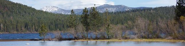
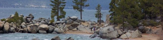
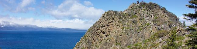
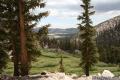
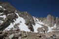
It is difficult to even discuss Inyo National Forest without loading up your backpack for a trek into the high sierra. This incredible region of California features staggering summits, epic glaciers, crystal clear lakes, and pristine pine forests. It is truly a hiker’s delight.
Highlights of Inyo National Forest


Inyo National Forest
Several distinct federally protected wilderness areas, including Golden Trout Wilderness and John Muir Wilderness, make up the nearly 3,000 square miles of Inyo National Forest. Mount Whitney, the highest mountain in the lower 48, is located on the edge of Inyo National Forest, as well as several 13,000-foot and 14,000-foot peaks. Inyo National Forest borders Sequoia National Park and contains several trails that cross the bother into the national park’s breathtaking backcountry.
Many of the trails below begin from Horseshoe Meadow and continue north and west into wilderness areas extending into Sequoia National Park. To the north, trailheads near Mammoth Lakes facilitate the beautiful Ediza Lake – Thousand Island Lake Loop.
Inyo National Forest Hiking
This collection of trails in Inyo National Forest lists the hikes from south to north. The table may also be sorted alphabetically or by distance to help you select your next trek. Each trail links to its own report complete with photos, maps, directions, and all the other information needed to locate and enjoy these trails. Below the table is an interactive map showing the location of each hike.
Trail | Description | Distance | Location |
|---|---|---|---|
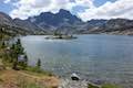
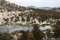
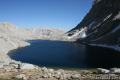
 243 243 | Thousand Island Lake This exceptional lake is a true gem of the Sierra, reached via a section of Pacific Crest Trail through Ansel Adams Wilderness near Mammoth Lakes. | 18 miles 1,515 feet | 37.682865, -119.0847 |
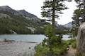 245 245 | Shadow Lake This hike crosses a picturesque canyon and passes a plunging cascade to visit a mountain lake in Ansel Adams Wilderness near Mammoth Lakes. | 8.5 miles 750 feet | 37.682, -119.086 |
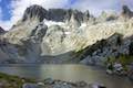
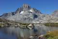
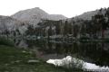
 246 246 | Ediza Lake This hike ventures above Shadow Lake along a creek to a beautiful lake below Mount Ritter and Banner Peak. | 15 miles 1,250 feet | 37.682, -119.086 |
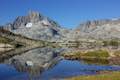
 247 247 | Iceberg Lake This short extension off the trail to Ediza Lake heads to a higher lake in a sublime setting below a ridge of steep spires called the Minarets. | 1 mile (extension) 510 feet | 37.682, -119.086 |
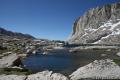
 249 249 | Garnet Lake This beautiful lake along John Muir Trail lies between Shadow Lake and Thousand Island Lake, making it an ideal stop on a backpacking loop. | 17.1 miles 2,070 feet | 37.682, -119.086 |
 251 251 | Ediza Lake - Thousand Island Lake Loop This multi-day trek incorporates sections of John Muir Trail and Pacific Crest Trail to visit a series of stunning Sierra lakes in the Ansel Adams Wilderness of Inyo National Forest. | 25 miles 2,110 feet | 37.682, -119.086 |
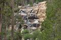 254 254 | Minaret Falls This out and back hike from Devils Postpile National Monument connects with Pacific Crest Trail to reach the base of a waterfall that tumbles and slides down a rocky slope. | 3 miles 125 feet | 37.6299, -119.0847 |
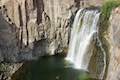 258 258 | Rainbow Falls This hike passes the Devils Postpile Formation to reach an attractive 101-foot waterfall with rainbows in its mist. | 5.1 - 5.25 miles 325 - 435 feet | 37.6299, -119.0847 |
 700 700 | Cottonwood Pass This trail leaves Horseshoe Meadow for an 11,200-foot pass and a junction with the Pacific Crest Trail, with access to Golden Trout Wilderness and Sequoia National Park. | 7 miles 1,200 feet | 36.44834, -118.17065 |
 710 710 | Chicken Spring Lake This hike continues past Cottonwood Pass to an alpine lake that makes a nice day hike destination or a good first camp for backpackers. | 8.2 miles 1,330 feet | 36.44834, -118.17065 |
 720 720 | Old Cottonwood Creek Trail This hike follows a secluded trail through mountain meadows to the South Fork Lakes and Cirque Lake. | 8 - 9 miles 1,150 feet | 36.4532, -118.1699 |
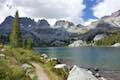
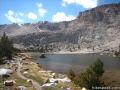 730 730 | Cottonwood Lakes This scenic trail provides a day hike through a lake-filled basin and access to New Army Pass, a 12,300-foot pass on the border of Sequoia National Park. | 10 - 15 miles 1,400 - 2,350 feet | 36.4532, -118.1699 |
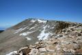 740 740 | Cirque Peak This 12,900-foot summit can be reached via off-trail ascents from New Army Pass, Cirque Lake, and Chicken Spring Lake. | 13 - 19 miles 2,900 feet | 36.476732, -118.237023 |
 750 750 | Lower Soldier Lake in Sequoia National Park This 19.2-mile loop crosses Cottonwood Pass and New Army Pass to visit a beautiful lake that is an ideal camping spot for backpackers heading higher and deeper into the Sierra. | 17.6 -20.8 miles 1,500 - 2,350 feet | 36.503604, -118.269331 |
 760 760 | Mount Langley in Sequoia National Park This trek travels past Cottonwood Lakes Trail over New Army Pass to a 14,042-foot summit with towering views of the Sierra. | 22 miles 4,000 feet | 36.4532, -118.1699 |
 770 770 | Sky Blue Lake in Sequoia National Park This hike extends beyond Lower Soldier Lake up Miter Basin to a deep blue lake surrounded by 14,000-foot peaks. | 26 miles 2,350 feet | 36.532788, -118.273494 |
 780 780 | Primrose Lake in Sequoia National Park This trek visits a lake off the side of Miter Basin near Sky Blue Lake and below Mount Pickering. | 28 miles 2,350 feet | 36.521144, -118.276173 |
 790 790 | Mount Pickering in Sequoia National Park This 13,485-foot summit rises above Sky Blue Lake to offer sweeping views of the Sierra. | 30 miles 3,500 feet | 36.527133, -118.290875 |
Or explore hikes around Inyo National Forest on the Hike Finder Map