Hikes in Anza-Borrego Desert State Park
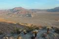
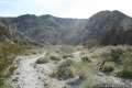
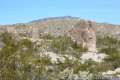
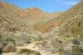
Anza-Borrego Desert State Park is the largest state park in California, covering nearly 1,000 square miles. It is only about twenty percent smaller than Joshua Tree National Park to the north and offers much to experience. Landscapes within the park range from badlands, to narrow canyons, to palm tree oases, and snow-capped peaks. Anza-Borrego Desert State Park has over 500 miles of dirt roads to travel down and plenty of trails to explore. If you are planning a trip to the California desert, Anza-Borrego Desert State Park has what you are looking for.
Highlights of Anza-Borrego Desert State Park


Visit Anza-Borrego Desert State Park
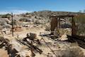
The name Anza-Borrego comes from Borrego, the Spanish word for Bighorn Sheep, and Anza, the last name of Juan Bautista de Anza, the Spanish explorer who led an expedition into this desert in 1774, becoming the first non-native to do so. Since Anza’s time, more settlers have come to this desert. There are numerous private land holdings within the park, including the city of Borrego Springs, home to the park visitor center and other useful amenities like gas stations and restaurants.
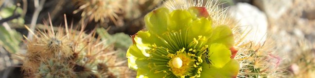
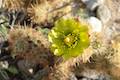
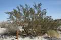
Cholla cacti, creosote bushes, and ocotillo are common throughout the park, which also features more rare vegetation like Elephant Trees. Desert wildflowers are one of the main draws to Anza-Borrego. Spring blooms add dazzling colors to the arid landscape.
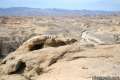
Elevation in the park varies from just 15 feet above sea level in the east near the Salton Sea to 6,193 feet in the northwest at Combs Peak. Daytime temperatures on the desert floor are typically in the seventies in the winter and well over one hundred degrees in the summer (not the best time to visit). Temperatures in higher elevations are milder and can be below freezing at night.
Dogs are welcome on leashes within campgrounds and on paved roadways. Dogs are not allowed on trails or in wilderness areas. Overall, the desert is not a good place for dogs. Burned paw pads, cactus quills, and snakebites pose a danger to dogs. Canines threaten desert wildlofe as well. A dog’s scent can scare animals away from trail areas, shrinking the habitat they rely on to survive.
The Anza-Borrego Desert sits at the south end of the Colorado Desert on the eastern edge of San Diego County. The park is about ninety minutes from downtown San Diego and three hours from Los Angeles. Once you get to the Anza-Borrego Desert, the camping options are plentiful. If you are not interested in sleeping on the ground, check out other lodging options on tripadvisor.com.
Anza-Borrego Desert State Park Hiking
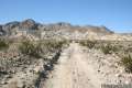
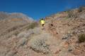
The trails below are listed from north to south and west to east. The hikes may also be sorted alphabetically or by distance to help plan a trip to Anza-Borrego Desert State Park. Each trail links to its own report complete with photos, maps, directions, and everything needed to explore the park. You can also view hikes around Anza-Borrego Desert State Park on the Hike Finder Map.
Trail | Description | Distance | Location |
|---|---|---|---|
 810 810 | Calcite Mine Trail This figure-eight shaped lollipop loop visits enthralling narrows and a mine site important to the history of the Anza-Borrego Desert. | 4 - 4.25 miles 600 feet | 33.2811, -116.0964 |
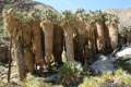 820 820 | Borrego Palm Canyon Trail This loop visits a popular palm tree oasis in a canyon west of Borrego Springs. | 3.25 miles 450 feet | 33.2702, -116.4182 |
 822 822 | Panoramic Overlook Trail The out and back hike ascends a ridge on the south side of Borrego Palm Canyon to sweeping views of the San Ysidro Mountains and Borrego Valley. | 1 mile 275 feet | 33.267663, -116.409476 |
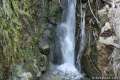 830 830 | Hellhole Canyon Trail to Maidenhair Falls This out and back hike visits a 20-foot waterfall in a canyon near Borrego Springs, making it the perfect place to cool off on a hot day in the California Desert. | 5.5 miles 1,000 feet | 33.248037, -116.40594 |
 833 833 | Culp Valley Loop This loop visits Culp Valley Overlook and Pena Springs, delivering views of the San Ysidro Mountains and Borrego Valley along the way. | 2.2 miles 200 feet | 33.2241, -116.454725 |
 836 836 | Tubb Canyon Trail to Big Spring This out and back hike follows a footpath across Tubb Canyon to Big Spring in a desert canyon below Pinyon Ridge in the San Ysidro Mountains. | 1.5 miles 200 feet | 33.211274, -116.438534 |
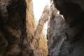 840 840 | The Slot This out and back hike crosses a narrow canyon beneath a natural rock span that is among the most photographed landmarks in the park. | 0.8 miles 100 feet | 33.18213, -116.21417 |
 843 843 | Kenyon Overlook Trail This loop sets out from Yaqui Pass to reach an incredible viewpoint across Mescal Bajada. | 1.15 miles 125 feet | 33.148143, -116.348653 |
 845 845 | Cactus Loop Trail This loop on a self-guided nature trail explores cacti and other plants that have adapted to survive in the Anza-Borrego Desert. | 0.75 miles 225 feet | 33.138755, -116.37494 |
 846 846 | Yaqui Well Trail This out and back hike on a self-guided nature trail explores area botany and history on the way to a rare desert water source. | 1.6 miles 100 feet | 33.138333, -116.37649 |
 850 850 | Village Site No hiking required to visit this Kumeyaay Indian Village Site on Mine Wash Road where you can find morteros in a collection of boulders. | 0.1 miles | 33.113076, -116.34512 |
 855 855 | Narrows Earth Trail This short self-guided loop explores the geology of the park. | 0.5 miles 50 feet | 33.13072, -116.30155 |
 860 860 | Elephant Trees Trail This easy loop offers a lesson in desert botany including the rare elephant tree. | 1 mile 50 feet | 33.068153, -116.1168 |
 870 870 | Pictograph Trail This out and back hike visits rock paintings drawn by Kumeyaay Indians who lived in the Anza-Borrego Desert thousands of years ago. | 1.8 miles 190 feet | 33.01965, -116.3598 |
 880 880 | Morteros Trail This out and back hike visits a village of boulders once occupied by Kumeyaay Indians who left behind Morteros, grinding bowls carved into the rock. | 0.6 miles 40 feet | 33.00895, -116.3784 |
 890 890 | Marshal South Home Trail This out and back hike ascends to the ruins of an adobe cabin on Ghost Mountain (Yaquitepec) with great views above Blair Valley. | 1.3 miles 450 feet | 33.003382, -116.389789 |
 900 900 | Rainbow Canyon Trail This out and back hike follows an undeveloped trail up a colorful canyon full of vibrant rock formations and desert plants. | 2.2 miles 300 feet | 32.99775, -116.44755 |
 930 930 | Wind Caves Trail This short hike climbs to a sandstone formation that begs to be explored. | 1.25 miles 250 feet | 32.9933, -116.1184 |
Or explore hikes around Anza-Borrego Desert State Park on the Hike Finder Map
Are you looking for other places to explore around Death Valley? The California desert has more great parks to visit, like: