William L. Kenyon Overlook Trail (Bill Kenyon Trail)
in Anza-Borrego Desert State Park

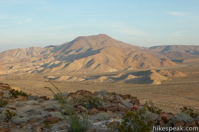
Looks can be deceiving. Kenyon Overlook Trail doesn’t impress at the start – a dirt single track leaving the most primitive campground in Anza-Borrego Desert State Park. The trail crosses pleasant but generic desert landscape at Yaqui Pass. Stick with this hike because the payoff is massive – a huge view across Mescal Bajada toward Sunset Mountain (which puts on a colorful display from the overlook at sunset). With just 125 feet of elevation change on this 1.15-mile loop, this is one of the best rewards-for-the-effort hikes in the California desert.
You can start this loop from two points, Yaqui Pass Primitive Campground and a second roadside trailhead along Yaqui Pass Road. Yaqui Pass is located at the east end of Pinyon Ridge where a roadway crosses the mountains to connect Borrego Springs with the south side of Anza-Borrego Desert State Park. To bridge the two trailhead to form the loop, you will hike 0.2 miles along Yaqui Pass Road.
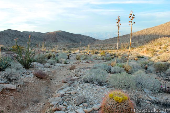
Setting out from Yaqui Pass Primitive Campground, which is nothing more than dirt parking area with no amenities (not even a bathroom), you will find a marked trailhead at the back of the parking area. William L, Kenyon Overlook Trail heads south across gradually undulating terrain, passing over miniature dips and ridges. Looking over your shoulder, you will spot Coyote Mountain popping up to the north over a gap in Pinyon Ridge.

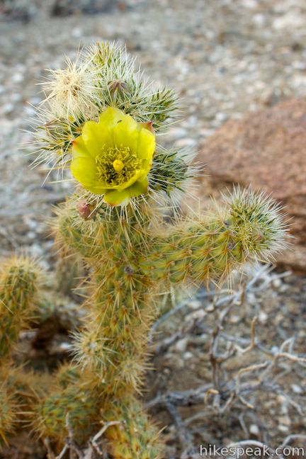
Hike up Kenyon Trail through desert plants like cholla cacti, ocotillo, agave, barrel cactus, and beavertail cactus. In the spring you can spot red flowers budding from the ocotillo, pink flowers on the beavertail cacti, and splashes of yellow on the barrel cacti and silver cholla cacti.

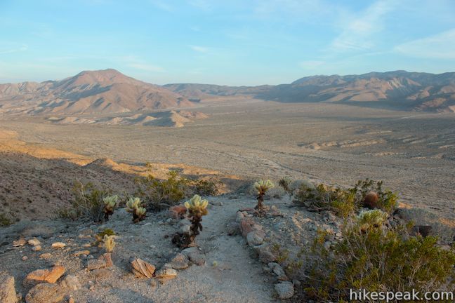
After less than half a mile of easy hiking, you will cross a path breaking off to the left out to a viewpoint above Mescal Bajada. The marked Keyon Overlook is just ahead, but the view from this spur is just as amazing. Take the detour to the vista point before continuing up Kenyon Overlook Trail. It is a short walk out to a round knoll on the mountainside overlooking Mescal Bajada and enjoy a sweeping view. From left to right, the view across Mescal Bajada includes Sunset Mountain, Pinyon Wash, Nolina Wash, Bighorn Canyon, Mine Canyon, San Felipe Wash, and Chuckwalla Wash.

Could the views get any better? Continue another tenth of a mile up the trail to reach the official Kenyon Overlook. Turn left up a second spur where you will pass a plaque on a boulder honoring William L. Kenyon, California’s Superintendent of District 6 of the State Division of Beaches and Parks from 1947 to 1959. Bill Kenyon Trail (William L. Kenyon Overlook Trail) is dedicated in his memory, because as the plaque states:
Mr. Kenyon was an ardent conservationist, tireless in his efforts to acquire and preserve these magnificent desert lands for the people of California and the nation.
Past the plaque, the path continues to a panel labeled Mescal Bajada, describing and depicting the enormous view laid out below. Mescal is the Spanish word for agave, a common plant in this area, recognizable for the tall flower stalk that it produces at the end of its lifecycle. Bajada is the word for a slope at the base of a desert mountain, typically covered in dry washes that come alive in flash floods. As the panel explains:
The stream beds (arroyos) below you may look dry today, but when it rains, look out! Over 35 arroyos feed into the broad Sen Felipe Wash on its journey to the Salton Sea. After a rain it becomes a muddy torrent, carrying sand and rocks in its flow.
The sign also explains that the rocky slopes around Kenyon Overlook are popular with bighorn sheep, so have a close look at the mountains around you. Linger and watch light and shadow change on the slopes of Sunset Mountain, rising above the lower east end of Mescal Bajada. Kenyon Overlook offers a stunning sunset view, when golden hues from the disappearing sun spread out across the desert below.

When the view has been fully absorbed, return to the main trail and continue the loop. You will reach Yaqui Pass Road after another quarter mile. The trailhead is right across a sign that read, Yaqui Pass – Elevation 1,750 feet. Turn right and walk 0.2 miles down the road to Yaqui Pass Primitive Campground. Turn right into the campground and walk back to your vehicle, completing this 1.15-mile loop with 125 feet of elevation change. Dogs and mountain bikes are not allowed on this trail, but no fee or permit is required to hike to Kenyon Overlook, so get out and enjoy!
To get to the trailhead: From Christmas Circle in Borrego Springs, drive 5 miles southwest on Borrego Springs Road. Turn right on Route S3 (Yaqui Pass Road) and drive 4.7 miles south to Yaqui Pass Primitive Campground (on the left). If you pass mile marker two, you went too far (and will soon see the roadside trailhead). Turn left into Yaqui Pass Primitive Campground and park near the trailhead at the back of the dirt parking area. Coming from the south by Tamarisk Grove Campgrounds, drive 2.2 miles up Yaqui Pass Road from the intersection with Route 78 to reach Yaqui Pass Campground on the east side of the road, just over Yaqui Pass.
Trailhead address: Yaqui Pass Road, Anza-Borrego Desert State Park, Borrego Springs, CA 92004
Trailhead coordinates: 33.148143, -116.348653 (33° 08′ 53.31″N 116° 20′ 55.15″W)
You may also view a regional map of surrounding California Desert trails and campgrounds.
 | Cactus Loop Trail This 0.75-mile loop on a self-guided nature trail explores cacti and other plants that have adapted to survive in the Anza-Borrego Desert. |
 | Yaqui Well Trail This 1.6-mile out and back hike on a self-guided nature trail explores area botany and history, crossing a wash to reach a rare desert water source. |
 | Narrows Earth Trail This 0.5-mile self-guided hike explores the geology of the park. |
 | The Slot This short hike descends through a narrow canyon beneath a natural rock span that is among the most photographed landmarks in Anza-Borrego Desert State Park. |
 | Hellhole Canyon Trail to Maidenhair Falls This 5.5-mile hike visits a 20-foot waterfall in a canyon near Borrego Springs, making it the perfect place to cool off on a hot day in the California Desert. |
 | Panoramic Overlook Trail The 1-mile round trip hike ascends a ridge on the south side of Borrego Palm Canyon to sweeping views of the San Ysidro Mountains and Borrego Valley. |
 | Borrego Palm Canyon Trail This 3.25-mile loop visits a popular palm tree oasis in a canyon west of Borrego Springs. |
 | Hikes in the California Desert Explore more trails in Death Valley National Park, Joshua Tree National Park, Anza-Borrego Desert State Park, and Mojave National Preserve. |
 | Tamarisk Grove Campgrounds This shaded 27-site campground is one of four developed campgrounds in Anza-Borrego Desert State Park and the start of two self-guided nature trails. |
 | Anza-Borrego Desert Campgrounds There are four developed campgrounds, eight primitive campgrounds, and extensive roadside camping to accommodate your visit to California's largest state park. |
 | Anza-Borrego Desert State Park Wildflowers The desert bloom brings bursts of color to barrel cactus, beavertail cactus, ocotillo, and more. |


[…] Bill Kenyon Overlook was a great place to be around sunset, so I’d read. Not exactly off the beaten route, I was amazed we had it to ourselves. What a great place to bring this park altogether! With a diversity of scenery spread out below us, it was Anza Borrego Desert in a microcosm. […]