Cape Tourville in Freycinet National Park
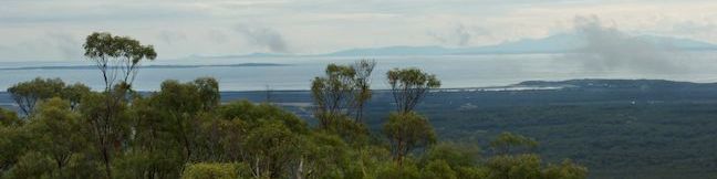
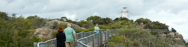
Freycinet National Park preserves a picturesque peninsula on Tasmania's east coast. The park's beaches are the pride of Tasmania, and if you've got slightly loftier ambitions, and you can get a great overview of the peninsula from Cape Tourville. An easy 600-meter long trail loops around this promontory on the peninsula's east coast, crossing 100-meter tall granite bluffs to reach the Cape Tourville Lighthouse, a naval beacon on the point. ...Read more.
Distance: 0.65 kilometers / 0.4 miles · Elevation change: 30 meters / 100 feet
By: Published: September 10, 2014 Last updated: December 5, 2025
Friendly Beaches in Freycinet National Park
Visit long stretches of light sand running along the pristine east coast of Tasmania north of the Freycinet Peninsula. The trail to Friendly Beaches is listed as one of Tasmania's 60 Great Short Walks, and it takes little effort to get from the car park to the beach. A 10-meter long boardwalk leads to an overlook behind the beach and another 10 meters of steps take you down to the sand. ...Read more.
Distance: 0.1 kilometers / 0.05 miles · Elevation change: 10 meters / 30 feet
By: Published: September 9, 2014 Last updated: April 14, 2026
Mount William in Mount William National Park
Rising to just 216 meters (708 feet) above sea level, Mount William is far from the tallest mountain in Tasmania. Despite its modest stature, Mount William is the highest point in Mount William National Park and offers far reaching 360-degree views over the northeast corner of Tasmania. The summit is close to the coast, with an ocean view that includes Flinders Island and the Bass Straight. ...Read more.
Distance: 3.6 kilometers / 2.25 miles · Elevation change: 140 meters / 460 feet
By: Published: August 22, 2014 Last updated: December 5, 2025
Pinnacles Boardwalk and Summit Trig on Mount Wellington in Wellington Park
If you're traveling to Tasmania by plane, you'll probably be flying in an out of Hobart, the capital of Tasmania. Hobart is a great city to explore, and every itinerary should include a visit to Mount Wellington, the 1,271-meter (4,170-foot) tall mountain that rises above the city to the wast. As daunting as this mountain might look, you can actually drive all the way to the top, easily reaching an incredible perspective over Hobart and what feels like a top-down view of Tasmania. ...Read more.
Distance: 0.75 kilometers / 0.45 miles · Elevation change: 20 meters / 65 feet
By: Published: August 19, 2014 Last updated: December 5, 2025
Octopus Tree and Circle Track in Wellington Park
Nature just seems a bit wilder in Tasmania. On the slopes of Mount Wellington in Hobart's Wellington Park, there's an Octopus Tree that takes its name from thick tentacle-like roots that wrap around a boulder below the tree. It's only a 0.3-kilometer walk to the tree from Shoobridge Bend on Pinnacles Road and the tree can be visited on a loop by incorporating Circle Track for an easy and enjoyable 1. ...Read more.
Distance: 1.1 kilometers / 0.7 miles · Elevation change: 50 meters / 165 feet
By: Published: August 17, 2014 Last updated: April 7, 2026
Zig-Zag Track, Cataract Walk, and Bridge Walk Loop in Cataract Gorge Reserve
Tasmania is a wild and rugged island with natural beauty around every turn. In fact, you don't even need to leave the major cities to see natural wonders. Hobart has Mount Wellington and Launceston has Cataract Gorge. Find Cataract Gorge Reserve just outside the city center, where the South Esk River courses down a deep, rugged trench. Trails run along both sides of the river to give hikers a variety of excellent views. ...Read more.
Distance: 3.4 kilometers / 2.1 miles · Elevation change: 80 meters / 260 feet
By: Published: August 10, 2014 Last updated: December 5, 2025
Balconies Cave in Pinnacles National Park
Pinnacles National Park preserves some of California's oddest landscapes with out-of-place rock spires and boulder-filled gorges with talus caves just waiting to be explored. Grab your headlamp and head to the west side of Pinnacles National Park for a trek into Balconies Cave. This fun 2-mile out and back hike or 2.4-mile lollipop loop hike crosses a playground of volcanic rock formations and journeys through the dark, twisting passages of Balconies Cave. ...Read more.
Distance: 2 miles · Elevation change: 200 feet
By: Published: July 31, 2014 Last updated: December 17, 2025
High Peaks – Balconies Cave Loop in Pinnacles National Park
Pinnacles National Park is a spectacular place to hike with a High Peaks area covered in rock spires and equally impressive boulder-filled gorges with talus caves. See both the High Peaks and Balconies Cave on a great 9-mile loop through diverse Pinnacles landscapes. Starting in the east, this clockwise loop ascends 1,575 feet to a thrilling crossing of the High Peaks, then descends Juniper Canyon to the west side of the park, and passes through Balconies Cave to close the hike with an easy walk back on Old Pinnacles Trail. ...Read more.
Distance: 9 miles · Elevation change: 1575 feet
By: Published: July 30, 2014 Last updated: April 9, 2026
Ridge Trail – Panorama Trail – Bluff Trail Loop in Andrew Molera State Park
Andrew Molera State Park's big loop trek centered over Ridge Trail, Panorama Trail, and Bluff Trail has about everything you could want in a Big Sur hike, including a redwood grove, an unspoiled beach, and lots of ocean views over a wild coastline. This is a hike for those who want to lose themselves in the majestic beautify of Big Sur. Ok, don't get lost, bring along these directions and immerse yourself in the area's natural beauty, enjoying spectacular seaside views and solitude in Andrew Molera State Park. ...Read more.
Distance: 8.7 miles · Elevation change: 1100 feet
By: Published: July 25, 2014 Last updated: April 10, 2026
Nature Trail – River Path Loop in Pfeiffer Big Sur State Park
You don't have to travel far beyond the entrance booth at Pfeiffer Big Sur State Park to get an introduction to the area's plants and animals. That's because the easy-walk providing Nature Trail starts from a day use lot just inside the park. Two additional trails along the Big Sur River in this area can be combined with the Nature Trail to form short easy loops. ...Read more.
Distance: 0.55 miles · Elevation change: 15 feet
By: Published: July 21, 2014 Last updated: December 9, 2025