Pfeiffer Falls and Valley View in Pfeiffer Big Sur State Park
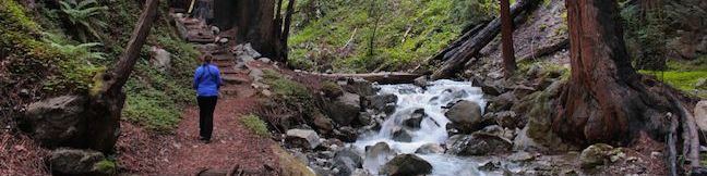
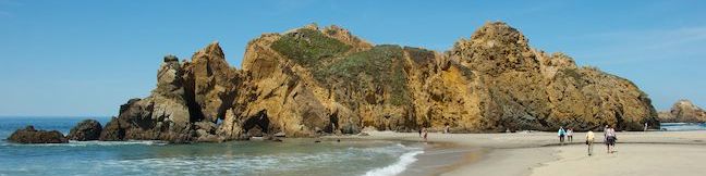
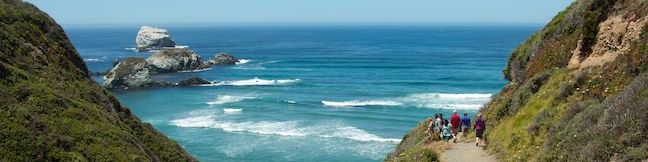
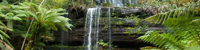
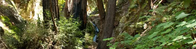
The trails to Pfeiffer Falls and Valley View are a perfect fit for hikers who like to multi-task. The versatile hike in Pfeiffer Big Sur State Park has a bit of everything. See impressive redwood trees in a shaded canyon, examine colorful wildflowers on a sunny ridge, admire a charming waterfall, and gaze out from a vista point that looks all the way down the Big Sur River Valley to the Pacific Ocean. ...Read more.
Distance: 2.4 miles · Elevation change: 550 feet
By: Published: July 20, 2014 Last updated: December 9, 2025
Big Sur River Gorge in Pfeiffer Big Sur State Park
Big Sur River Gorge is one of the big draws at Pfeiffer Big Sur State Park, facilitating a romp to a swimming hole in the wilds of Big Sur. An unmaintained trail connects the park's campground to a inviting pool of clear river water in a granite-walled gorge. Multiple river crossings along the way make for a rock-hopping hike of half a mile round trip. ...Read more.
Distance: 0.5 miles · Elevation change: 75 feet
By: Published: July 19, 2014 Last updated: December 9, 2025
Hare Creek Trail, Limekiln Trail, and Falls Trail in Limekiln State Park
For pleasant hiking along creeks in canyons shaded by coast redwoods, you can't do much better than Limekiln State Park in Big Sur. A trio of short trails in the park provide variety and great scenery on a 2.65-mile round trip hike with 250 feet of elevation gain. Hare Creek Trail is a supremely peaceful creekside stroll, as is Limekiln Trail, which heads to historic lime kilns that the park has preserved, and Falls Trail ascends another fork of Limekiln Creek to a hundred-foot tall waterfall. ...Read more.
Distance: 2.65 miles · Elevation change: 250 feet
By: Published: July 18, 2014 Last updated: December 9, 2025
Pfeiffer Beach in Los Padres National Forest (Big Sur)
Most of Big Sur's beautify is obvious – tall green mountains, a ragged coastline, and lots of ocean blue, but some attractive features are practically hidden, and Pfeiffer Beach is one such gem. Pfeiffer Beach has great sand and iconic rock formations, but you won't see this beach from Highway One (or its begging-to-be-photographed wave-tunneled rocks). ...Read more.
Distance: 0.2 miles · Elevation change: 10 feet
By: Published: July 10, 2014 Last updated: December 7, 2025
Sand Dollar Beach in Los Padres National Forest (Big Sur)
Big Sur has a dramatic rocky coastline that's stunning to look at, but can be challenging to access. Where do you go when you want to take a good walk on the beach? To dip your toes in Big Sur's sand, there may be nowhere better to visit than Sand Dollar Beach. This half-mile long beach (or longer if the tide is out) is a crescent-shaped arc of pale sand between the blue water of the Pacific Ocean and the orange rock of tall sea cliffs. ...Read more.
Distance: 0.5 miles · Elevation change: 125 feet
By: Published: July 8, 2014 Last updated: December 5, 2025
Russell Falls and Horseshoe Falls in Mount Field National Park
Russell Falls is likely the most-visited attraction in Mount Field National Park, and one of Tasmania's best-known waterfalls. There is a viewing area at the base of the approximately 50-meter tall (165-foot tall) waterfall that can be reached on a 1.8-kilometer (1.1-mile) round trip hike with 30 meters of elevation gain. Trails travel through an old and well-established rainforest to deliver an intimate look at the broad and beautiful waterfall. ...Read more.
Distance: 2.65 kilometers / 1.65 miles · Elevation change: 80 meters / 265 feet
By: Published: July 3, 2014 Last updated: April 9, 2026
Moorland Mosaic in Mount Field National Park
If you're someone who pays attention to small details, the short, easy hike to Moorland Mosaic may be for you. This 2/3 of a kilometer round trip hike in Mount Field National Park won't produce the area's grandest vistas, but it will give you a good opportunity to examine an interesting mix of vegetation in an alpine meadow. There is only 20 meters of elevation gain on this boardwalk trail, creating an easy outing that can be stretched by continuing up the trail to Lake Belcher and Lake Benton. ...Read more.
Distance: 0.66 kilometers / 0.4 miles · Elevation change: 20 meters / 65 feet
By: Published: July 3, 2014 Last updated: December 5, 2025
Canyon Falls in Julia Pfeiffer Burns State Park
Julia Pfeiffer Burns State Park in Big Sur has a word famous waterfall named McWay Falls, which tumbles off a coastal bluff straight into the Pacific Ocean in a display of unique natural beauty. The park has a second waterfall too, just inland from McWay Falls, with the more generic name of Canyon Falls. This lovely little waterfall can't rival McWay for postcard beauty, but the 0. ...Read more.
Distance: 0.9 miles · Elevation change: 225 feet
By: Published: June 30, 2014 Last updated: December 7, 2025
Vital Link Trail in the Verdugo Mountains
With an inspired name and inspiring view, Vital Link Trail presents a rewarding hike in the Verdugo Mountains near Burbank. The trail delivers a good workout too, ascending 1,275 feet in a mile and a half, with opportunities to hike even farther. The steep single track looks out over the east end of the San Fernando Valley toward the Santa Monica Mountains and the skyscraper skyline of downtown Los Angeles. ...Read more.
Distance: 3 miles · Elevation change: 1275 feet
By: Published: June 28, 2014 Last updated: April 9, 2026
Apsley Waterhole & Lookout Track in Douglas-Apsley National Park
Whether you're looking for a short walk to a swimming hole or a longer woodland hike to a gorge, Douglas-Apsley National Park has you covered. While it is a 5.6-kilometer round trip hike to Apsley Gorge, you'll discover Apsley Waterhole just 600 meters from the car park. Combine Apsley Waterhole with Lookout Track for a 1.4-kilometer (0.9-mile) loop with 30 meters (100 feet) of elevation gain, adding a forest walk and views over the Apsley River to your outing. ...Read more.
Distance: 1.4 kilometers / 0.9 miles · Elevation change: 30 meters / 100 feet
By: Published: June 24, 2014 Last updated: April 21, 2026