Saint Columba Falls in Saint Columba Falls State Reserve
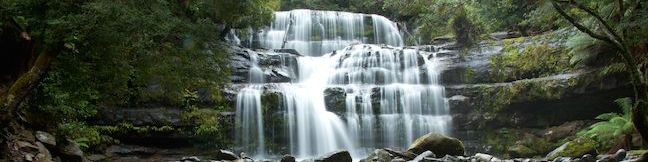
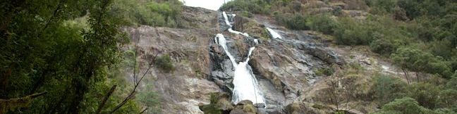
Saint Columba Falls Nature Walk offers an action-packed 1.2-kilometer (0.75-mile) round trip trek. Without the waterfall, this would be a pleasant hike through a charming Tasmanian rainforest. To put things over the top, this hike ends at a waterfall, and an impressive one at that. The walk terminates at a viewing platform below booming Saint Columba Falls, one of Tasmania's tallest falls at 90 meters (295 feet). ...Read more.
Distance: 1.2 kilometers / 0.75 miles · Elevation change: 40 meters / 130 feet
By: Published: June 23, 2014 Last updated: April 21, 2026
Liffey Falls in Liffey Falls State Reserve
Tumbling through an enchanting Tasmania rainforest, Liffey Falls is considered one of the island state's prettiest waterfalls. A 2.2-kilometer (1.4-mile) round trip walking track to the falls descends 70 meters in elevation past three enticing cascades in the Liffey River before reaching the photogenic falls. The trail is located in Liffey Falls State Reserve near the center of Tasmania in the Great Western Tiers, mountains southwest of the city of Launceston. ...Read more.
Distance: 2.2 kilometers / 1.4 miles · Elevation change: 70 meters / 230 feet
By: Published: June 20, 2014 Last updated: April 21, 2026
Cape Woolamai on Phillip Island
Cape Woolamai is a 308-hectar (760-acre) reserve established in 1968. The preserve protects the southeast end of Phillip Island and also the highest point on the island, a 112-meters-above-sea-level crest on the bluffs at the top of Cape Woolamai. The summit isn't much of a climb, so sandy beaches and stunning granite cliffs are the real draw for hikers. ...Read more.
Distance: 8.5 kilometers / 5.3 miles · Elevation change: 112 meters / 365 feet
By: Published: June 5, 2014 Last updated: December 5, 2025
Koala Conservation Reserve on Phillip Island
While it only covers about one hundred square kilometers, Phillip Island in Victoria Australia has numerous opportunities to see wildlife. To see koalas amongst the eucalyptus, the place to go is the Koala Conservation Reserve. Koala Conservation Reserve has an informative visitor center, walking trails, and elevated boardwalks where you see koalas up close. ...Read more.
Distance: 1.2 kilometers / 0.75 miles · Elevation change: 15 meters / 50 feet
By: Published: May 27, 2014 Last updated: April 8, 2026
Penguin Parade to the Nobbies on Phillip Island
The western end of Phillip Island holds two of the island's top attractions, the Nobbies and the Penguin Parade, which can be connected by an oceanfront stroll through a scenic reserve on the southern coast of Phillip Island. This walk is not actually along a trail, but on a gravel road that can be used by hikers, bikers, and drivers. Why go for a hike on a road you could drive on? ...Read more.
Distance: 8 kilometers / 5 miles · Elevation change: 25 meters / 80 feet
By: Published: May 16, 2014 Last updated: April 8, 2026
Summerlands Beach on Phillip Island
In the morning and early afternoon, Summerlands Beach is a low-key place to visit, with a surf break and lots of sand for building castles or having a picnic. In the evening, the beach transforms as visitors gather to watch the Penguin Parade, a nightly return of thousands of little penguins that commute up the beach to burrows in the surrounding bluffs. ...Read more.
Distance: 1 kilometer / 0.6 miles · Elevation change: 10 meters / 30 feet
By: Published: May 6, 2014 Last updated: April 8, 2026
The Nobbies Boardwalk at Point Grant on Phillip Island
Phillip Island in Victoria, Australia has a lot to offer its visitors, like beautiful coastlines and the internationally-heralded Penguin Parade. Point Grant, the western tip of Phillip Island is just a few kilometers past the Penguin Parade facilities at Summerlands Beach and home to a seal colony, dramatic sea bluffs, and panoramic ocean views. Point Grant is better known as the Nobbies, a name that comes either from the domes at the end of the point or from areas of cobblestone rocks that can poke out of the water like knobs when the tide is at the right level. ...Read more.
Distance: 1 kilometer / 0.6 miles · Elevation change: 15 meters / 50 feet
By: Published: May 4, 2014 Last updated: April 9, 2026
Pyramid Rock on Phillip Island
Pyramid Rock is a triangle-shaped rock island just off the southern coast of Phillip Island, a popular destination in Victoria, Australia made famous by the Penguin Parade. A short 800 meter (0.5 miles) round trip return walk travels out onto a grassy point approaching Pyramid Rock. Overlooks at the midway point and the end of this short trail allow hikers to take in coastal views that extend to both ends of the 26-kilometer long island, from Cape Woolamai to the east to Point Grant to the west. ...Read more.
Distance: 0.8 kilometers / 0.5 miles · Elevation change: 10 meters / 30 feet
By: Published: May 1, 2014 Last updated: December 5, 2025
South Norman Beach, Norman Point, and Little Oberon Bay in Wilsons Promontory National Park
Wilsons Promontory is the southernmost point on Mainland Australia and it stands out in other ways too, with coastal beauty that's hard to beat. See what the Prom has to offer on this day hike across a boulder-strewn point between bays of clear turquoise water with pale sand beaches. There are ocean and mountain views to enjoy at every turn of this walk as it takes you from the park's main hub at Tidal River to the south end of Norman Beach and then across Norman Point to Little Oberon Bay. ...Read more.
Distance: 9.5 kilometers / 5.9 miles · Elevation change: 70 meters / 230 feet
By: Published: April 25, 2014 Last updated: April 8, 2026
Monserate Mountain in Fallbrook
Monserate Mountain offers a workout of a hike, beginning just off Interstate 15 in the Northern San Diego County city of Fallbrook, just ten miles south of Temecula in Riverside County. There is 1,200 vertical feet between the trailhead at the base of Monserate Mountain and the panoramic summit at the top, tackled on a 1 2/3-mile ascent. You can turn around at the top for a 3 1/3-mile out-and-back hike or explore more of Monserate Mountain Preserve on a 4. ...Read more.
Distance: 4.4 miles · Elevation change: 1200 feet
By: Published: February 11, 2014 Last updated: December 5, 2025