Coulter Group Campground Chilao Campground Los Angeles San Gabriel Mountains Angeles National Forest California tent camping
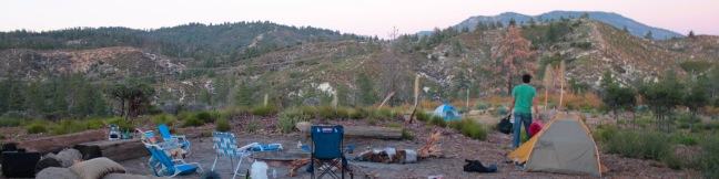
If you are planning an overnight group outing in the San Gabriel Mountains, consider Coulter Group Campground. This one-site campground is operated by the Angeles National Forest in San Gabriel Mountains National Monument and is nestled in a forest of oaks, firs, and Jeffrey pines at an elevation of 5,300 feet. Up to 50 people per night can enjoy fresh mountain air and sweeping views at this accommodating group campsite. ...Read more.
TagsA green icon depicting a tags represents a list of words and phrases that this content is tagged with Tagged with · Angeles National Forest · San Gabriel Mountains National Monument · Silver Moccasin Trail · Tent Camping · San Gabriel Mountains
By: Published: Last updated: October 8, 2024
Vanalden Cave Hike hike Vanalden Trail vista point Santa Monica Mountains Vanalden Vista
Vanalden Cave near Tarzana is one of the most unusual sandstone formations in the Santa Monica Mountains and is quite easy to hike to. Vanalden Cave is a sandstone den about 25 feet tall, 25 feet wide, and 50 feet deep. The roof of the cave is only a few feet thick with a few holes that, like skylights, illuminate cave walls covered with curious carvings and graffiti. ...Read more.
My Hikes: Completed hikeA green icon of shows a picture of a landscape with a check mark in the upper right corner, signifying that this is a hike you would like to put on your completed list.OK! Add to trails I've hiked
My Hikes: Want to hikeA green icon of shows a picture of a landscape with a heart in the upper right corner, signifying that this is a hike you would like to put on your to-do list.OK! Add to trails I want to hike
TagsA green icon depicting a tags represents a list of words and phrases that this content is tagged with Tagged with · Bike Trail · Caves · Free Trails · Tarzana · Dog-Friendly Trails · Santa Monica Mountains
Hike DistanceA green icon of a hiker used to label information about the length of the hike Distance: 0.6 miles · Elevation change: 100 feet
By: Published: Last updated: January 17, 2018
Garcia Trail to Azusa Peak A sign Glendora Ridge Motorway Glendora Peak hike San Gabriel Mountains
In Griffith Park, Mount Lee has the Hollywood Sign. In the San Gabriel Mountains, Azusa Peak has the A. The big white uppercase A just below the summit is hard to miss from the city below. You can hike to the A and up to the top of Azusa Peak on a 2 2/3-mile out and back hike with 1,275 feet of elevation change. After the steep climb, you have the option to hike to a second peak, Glendora Peak, expanding the trek to 4 2/3 miles round trip with 1,800 feet of elevation change. ...Read more.
My Hikes: Completed hikeA green icon of shows a picture of a landscape with a check mark in the upper right corner, signifying that this is a hike you would like to put on your completed list.OK! Add to trails I've hiked
My Hikes: Want to hikeA green icon of shows a picture of a landscape with a heart in the upper right corner, signifying that this is a hike you would like to put on your to-do list.OK! Add to trails I want to hike
TagsA green icon depicting a tags represents a list of words and phrases that this content is tagged with Tagged with · Azusa · Free Trails · Summits · Dog-Friendly Trails · Mountain Biking Trails · San Gabriel Mountains
Hike DistanceA green icon of a hiker used to label information about the length of the hike Distance: 4.66 miles · Elevation change: 1800 feet
By: Published: Last updated: January 9, 2018
Placerita Canyon Nature Center hike Ecology Trail Newhall
Placerita Canyon Natural Area is an interesting park on the west end of the San Gabriel Mountains near Newhall Pass. Gold was discovered in Placerita Canyon in 1842, and a century later the canyon rushed onto the silver screen as a backdrop for westerns. Today, the park is home to the Placerita Canyon Nature Center where you can learn about local plants and animals. ...Read more.
My Hikes: Completed hikeA green icon of shows a picture of a landscape with a check mark in the upper right corner, signifying that this is a hike you would like to put on your completed list.OK! Add to trails I've hiked
My Hikes: Want to hikeA green icon of shows a picture of a landscape with a heart in the upper right corner, signifying that this is a hike you would like to put on your to-do list.OK! Add to trails I want to hike
TagsA green icon depicting a tags represents a list of words and phrases that this content is tagged with Tagged with · California State Parks · Free Trails · Nature Trails · Newhall · Placerita Canyon Natural Area · Placerita Canyon State Park · Dog-Friendly Trails · San Gabriel Mountains
Hike DistanceA green icon of a hiker used to label information about the length of the hike Distance: 0.65 miles · Elevation change: 100 feet
By: Published: Last updated: March 12, 2021
Placerita Canyon hike Waterfall Trail seasonal falls Newhall Los Pinetos Creek Waterfall trek Los Pinetos Canyon Falls
Located on the west end of the San Gabriel Mountains, Placerita Canyon Natural Area (also know as Placerita Canyon State Park) is an interesting park that has something for everyone. There are easy canyon trails and tougher backcountry tracks, along with a nature center and an Ecology Trail that offers an easy loop for those interested in local plants. ...Read more.
My Hikes: Completed hikeA green icon of shows a picture of a landscape with a check mark in the upper right corner, signifying that this is a hike you would like to put on your completed list.OK! Add to trails I've hiked
My Hikes: Want to hikeA green icon of shows a picture of a landscape with a heart in the upper right corner, signifying that this is a hike you would like to put on your to-do list.OK! Add to trails I want to hike
TagsA green icon depicting a tags represents a list of words and phrases that this content is tagged with Tagged with · California State Parks · Creeks · Free Trails · Newhall · Placerita Canyon Natural Area · Placerita Canyon State Park · Ruins · Waterfalls · Dog-Friendly Trails · Los Angeles Waterfalls · San Gabriel Mountains
Hike DistanceA green icon of a hiker used to label information about the length of the hike Distance: 5.33 miles · Elevation change: 560 feet
By: Published: Last updated: December 7, 2018
Caballero Canyon Trail Santa Monica Mountains hike Reseda Los Angeles California Topanga State Park Marvin Braude Mulholland Gateway Park
Located on the north side of the Santa Monica Mountains in Tarzana, Caballero Canyon Trail is a straightforward dirt single track that ascends 625 feet over 1.7 miles to an unpaved section of Mulholland Drive. Caballero Canyon Trail makes a satisfying 3.4-mile round trip hike (or ride if you take your mountain bike), and extensions are available to places like San Vicente Mountain. ...Read more.
My Hikes: Completed hikeA green icon of shows a picture of a landscape with a check mark in the upper right corner, signifying that this is a hike you would like to put on your completed list.OK! Add to trails I've hiked
My Hikes: Want to hikeA green icon of shows a picture of a landscape with a heart in the upper right corner, signifying that this is a hike you would like to put on your to-do list.OK! Add to trails I want to hike
TagsA green icon depicting a tags represents a list of words and phrases that this content is tagged with Tagged with · California State Parks · Free Trails · Marvin Braude Mulholland Gateway Park · Tarzana · Dog-Friendly Trails · Mountain Biking Trails · Santa Monica Mountains · Topanga State Park
Hike DistanceA green icon of a hiker used to label information about the length of the hike Distance: 3.4 miles · Elevation change: 625 feet
By: Published: Last updated: January 17, 2018
Rocky Peak Park summit hike Simi Valley Los Angeles California
Rocky Peak is a panoramic 2,715-foot summit on the border between Los Angeles and Ventura counties in the Santa Susana Mountains. The county line-straddling peak stands at the center of a 4,800-acre park bearing the same name. The shortest hike to Rocky Peak takes Rocky Peak Trail from Rocky Peak Road through Rocky Peak Park. Oh boy, we're off to a rocky start. ...Read more.
My Hikes: Completed hikeA green icon of shows a picture of a landscape with a check mark in the upper right corner, signifying that this is a hike you would like to put on your completed list.OK! Add to trails I've hiked
My Hikes: Want to hikeA green icon of shows a picture of a landscape with a heart in the upper right corner, signifying that this is a hike you would like to put on your to-do list.OK! Add to trails I want to hike
TagsA green icon depicting a tags represents a list of words and phrases that this content is tagged with Tagged with · Free Trails · Mountains Recreation and Conservation Authority · Santa Susana Mountains · Simi Valley · Summits · Wind Caves · Dog-Friendly Trails · Mountain Biking Trails
Hike DistanceA green icon of a hiker used to label information about the length of the hike Distance: 4.75 miles · Elevation change: 900 feet
By: Published: Last updated: December 7, 2018
Amir's Garden trail Griffith Park hike Los Angeles
Amir's Garden is no mere garden; it's one of two unique and awesome picnic areas on the east side of Griffith Park. The most surprising place for a picnic is probably the Old Zoo Picnic Area, where you can dine alongside old animal pens. Amir's Garden is the most pleasant place for a hike-in picnic, with a selection of picnic tables surrounded by a volunteer-supported sanctuary of flowering greenery. ...Read more.
My Hikes: Completed hikeA green icon of shows a picture of a landscape with a check mark in the upper right corner, signifying that this is a hike you would like to put on your completed list.OK! Add to trails I've hiked
My Hikes: Want to hikeA green icon of shows a picture of a landscape with a heart in the upper right corner, signifying that this is a hike you would like to put on your to-do list.OK! Add to trails I want to hike
TagsA green icon depicting a tags represents a list of words and phrases that this content is tagged with Tagged with · Free Trails · Picnic Area · Dog-Friendly Trails · Griffith Park · Santa Monica Mountains
Hike DistanceA green icon of a hiker used to label information about the length of the hike Distance: 1 mile · Elevation change: 275 feet
By: Published: Last updated: December 7, 2018
Mount Hollywood, Mount Bell, and Mount Chapel hike peaks trails Griffith Park summit trek Griffith observatory hike
If you're interested in getting some exercise with panoramic views over Griffith Park, consider hiking a loop to the summit's of three park peaks: Mount Chapel, Mount Bell, and Mount Hollywood. Starting from Hollyridge Trail at the top of Beachwood Drive, this 5.7-mile loop ascends 675 vertical feet, from 950 feet at the trailhead to 1,625 feet at the summit of Mount Hollywood, the tallest of the three peaks. ...Read more.
My Hikes: Completed hikeA green icon of shows a picture of a landscape with a check mark in the upper right corner, signifying that this is a hike you would like to put on your completed list.OK! Add to trails I've hiked
My Hikes: Want to hikeA green icon of shows a picture of a landscape with a heart in the upper right corner, signifying that this is a hike you would like to put on your to-do list.OK! Add to trails I want to hike
TagsA green icon depicting a tags represents a list of words and phrases that this content is tagged with Tagged with · Free Trails · Hollywood · Summits · Dog-Friendly Trails · Griffith Park · Santa Monica Mountains
Hike DistanceA green icon of a hiker used to label information about the length of the hike Distance: 5.7 miles · Elevation change: 675 feet
By: Published: Last updated: May 13, 2025
Hollyridge Trail Beachwood Canyon Hollywood Sign Hike Mount Lee Griffith Park
Hikers have several ways to reach the Hollywood Sign atop Mount Lee in Griffith Park. For a short steep hike, you could cross Cahuenga Peak for a tough 3-miler. For a lengthier 6.4-mile trek, you could hike from Brush Canyon Trail to Mount Lee. Hollyridge offers something in the middle, a 3.5-mile round trip hike that climbs 750 feet to the Hollywood Sign. ...Read more.
My Hikes: Completed hikeA green icon of shows a picture of a landscape with a check mark in the upper right corner, signifying that this is a hike you would like to put on your completed list.OK! Add to trails I've hiked
My Hikes: Want to hikeA green icon of shows a picture of a landscape with a heart in the upper right corner, signifying that this is a hike you would like to put on your to-do list.OK! Add to trails I want to hike
TagsA green icon depicting a tags represents a list of words and phrases that this content is tagged with Tagged with · Free Trails · Hollywood · Summits · Dog-Friendly Trails · Griffith Park · Santa Monica Mountains
Hike DistanceA green icon of a hiker used to label information about the length of the hike Distance: 3.5 miles · Elevation change: 750 feet
By: Published: Last updated: May 13, 2025