Bishop Peak
in San Luis Obispo
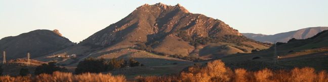
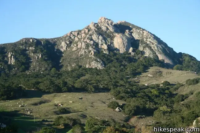
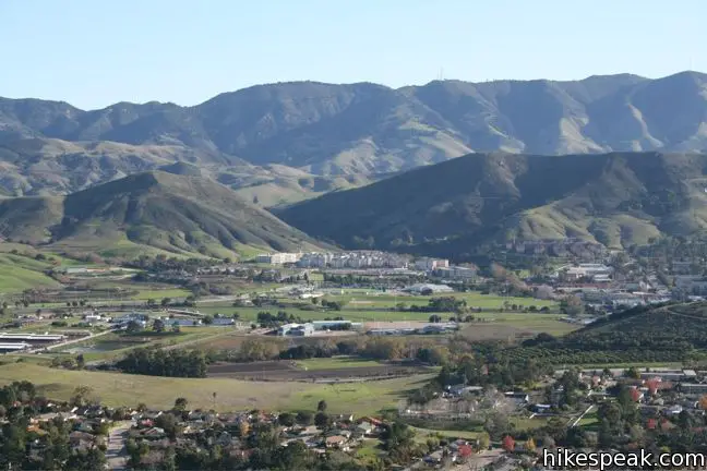
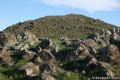
Sometimes called Bishop’s Peak, but more formally known as Bishop Peak, this mountain is the most sought after summit in San Luis Obispo. Bishop Peak is the tallest of the Nine Sisters, the picturesque volcanic Morros stretching across San Luis Obispo. The iconic mountain has a rocky crown shaped like a bishop’s miter, which provides panoramic views over the city and nearby peaks. The single-track trail to the 1,559-foot summit is demanding and rewarding – a truly excellent hike.
From the trailhead at the top of Highland Drive to the summit of Bishop Peak is 3.5 miles round trip with 950 feet of elevation gain. Anothe trailhead on Patricia Drive offers a slightly longer hike up Bishop Peak that is 4.2 miles round trip with 1,175 feet of elevation change.
Highland Drive to Bishop Peak
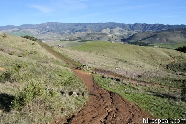
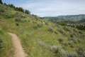
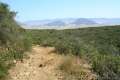
Pick up the trail on the left side of the cul-de-sac at the end of Highland Drive, and begin hiking along the left side of a wooden fence. The wide dirt trail passes through a shaded oak forest. Come to a cattle pond after a quarter mile, along with a junction with a trail to Bishop Peak from another trailhead on Patricia Drive.
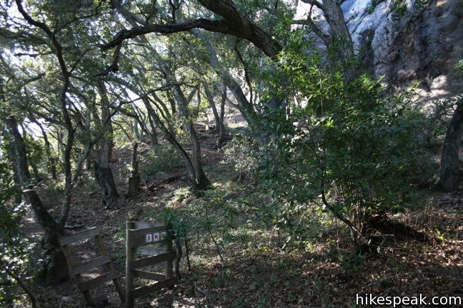
Turn left at the junction, following the wide road up a grassy slope. After another 0.15 miles, pass through a cattle gate to a junction with a connector trail to Felsman Loop Trail. Turn left, heading farther up the grass skirt of Bishop Peak. The trail returns to the trees, passing through a pleasant mixed forest of oaks and bays. Enjoy the temporary shade as you pass through another gate and a plaque commemorating the creation of Bishop Peak Natural Reserve.
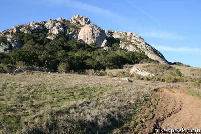
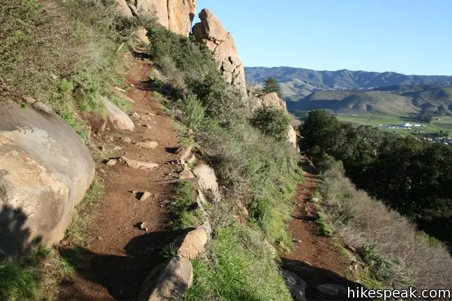
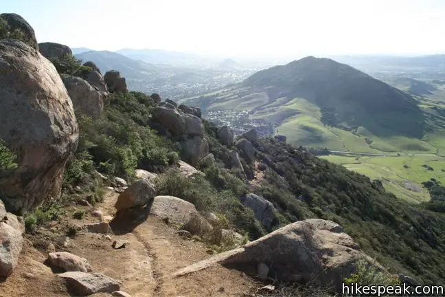
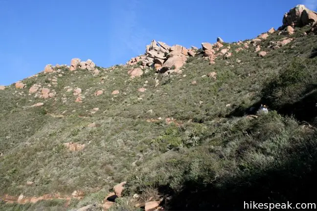
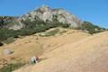
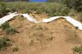
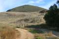
Exit the forest, 0.7 miles from the start, and begin switching up the rocky sun-exposed mountainside. The remainder of the hike is moderately strenuous, tackling 650 feet of elevation over 1.05 miles of switchbacks.
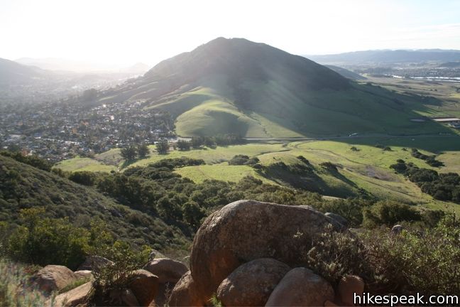
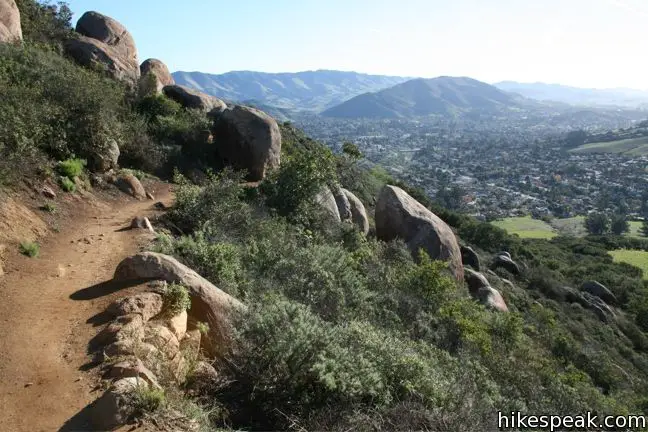
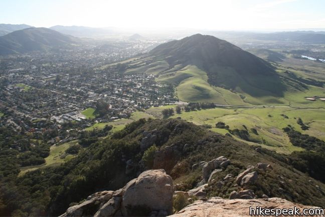
The rocky single track climbs the southern slope of Bishop Peak through orange boulders surrounded by thriving brush. The trail offers an excellent perspective of Cerro San Luis, the adjacent Morro to the east.
One mile from the start and 0.75 miles from the top, continue straight through a junction with an old trail coming up the mountain from Foothills Boulevard. This is a more direct route to the summit, which was used exclusively before the Bishop Peak Open Space and Natural Reserve were established and the current trail was built. Despite quite a few no trespassing signs, this old route across Madonna Ranch is still a much-used trail.
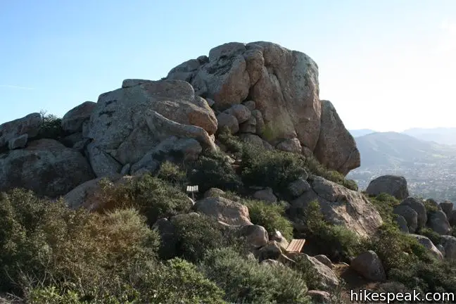
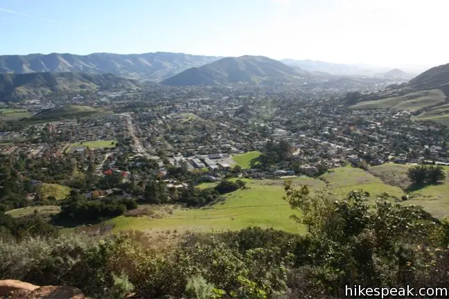
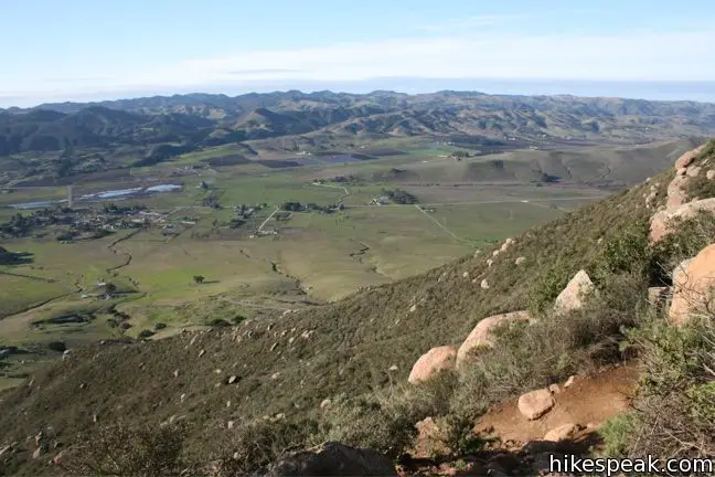
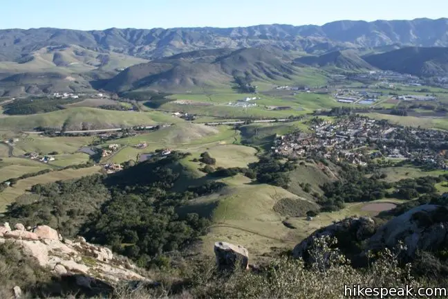
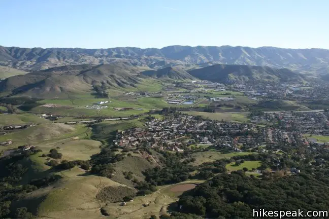
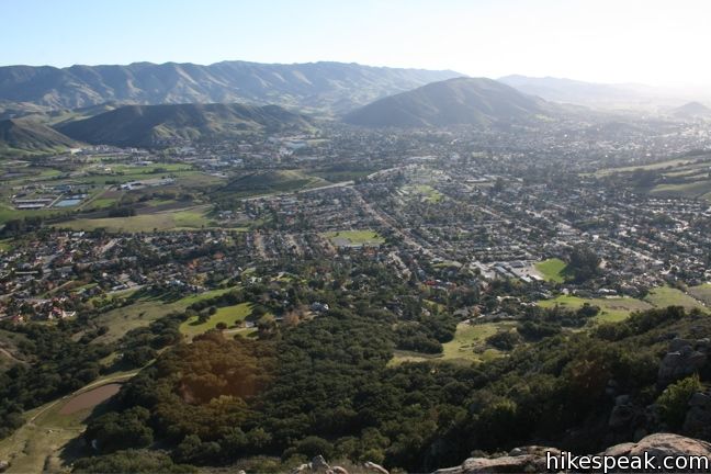
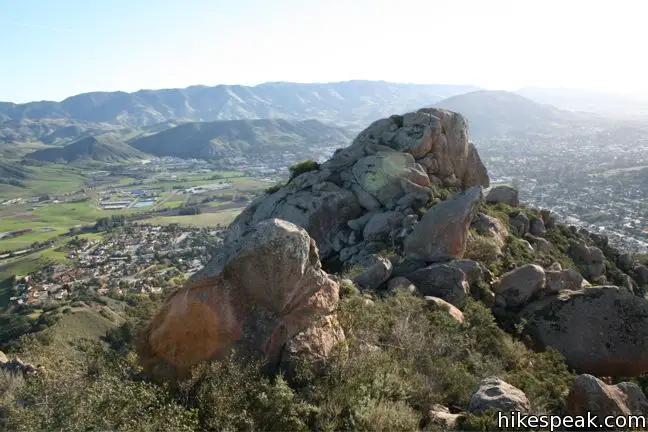
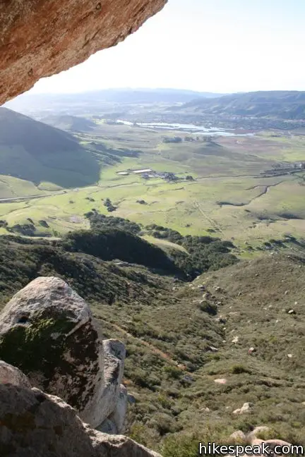
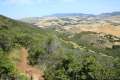
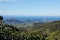
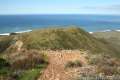
Two benches greet hikers at the top of Bishop Peak Trail. Either rest here or scramble higher up the rocks to the west or east for the most impressive views. The near summit to the right can be easily climbed by agile hikers. The grand rock offers a sweeping vista overlooking Cal Poly, downtown San Luis Obispo, Cerro San Luis, Laguna Lake, the Santa Lucia Mountains, and everything in between.
Exploring the west end of the peak can be trickier, but also quite fun. Massive boulders piled at the summit create windows and grottoes that are interesting to traverse. Getting to the top of these rocks requires technical climbing, but partial views are rewarded to bouldering hikers.
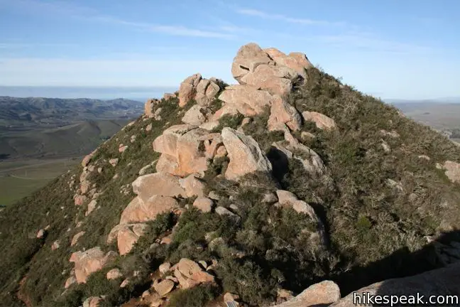
Bishop Peak is the tallest of the nine Morros, and is the third of the Nine Sisters from the east behind Islay Hill and Cerro San Luis. To the west rises Chumash Peak and the other volcanic prominences leading out to Morro Bay. The rocky three-pointed summit, which the padres at the San Luis Obispo Mission imagined resembled a bishop’s miter, makes an excellent hiking destination with beautiful views on a clear day.
Return the way you came for a 3.5-mile hike with 950 feet of elevation between the top and bottom of the trail. Mountain bikes are not allowed on Bishop Peak (instead try Cerro San Luis). Dogs are allowed on leash. No fee or permit is required, so get out and enjoy.
The basic directions up Bishop Peak are:
- Begin up the trail from the cul-de-sac at the top of Highland Drive (0 miles)
- Turn left at the junction after the cattle pond (0.25 miles)
- Pass through a cattle gate to a junction with a connector trail to Felsman Loop Trail and turn left (0.4 miles)
- Enter the forest and pass through the gate (0.5 miles)
- Leave the forest and begin up the switchbacks (0.7 miles)
- Continue straight through a junction with the old trail from Foothills Boulevard (1 mile)
- Arrive at the summit (1.75 miles)
Patricia Drive to Bishop Peak
If starting from Patricia Drive, hike up the trail for a quarter mile to a split on Felsman Loop Trail. Go up switchbacks for another quarter mile. Bear right at a junction and turn left at the next junction to connect to the trail up from Highland Avenue (a quarter mile from that trailhead). Turn right and hike up to another connector trail to Felsman Loop Trail and turn left to proceed up Bishop Peak.
Directions to the Trailhead
Highland Drive Trailhead:
- From Highway 101 in San Luis Obispo, take exit 203 B to Highway 1 North.
- Drive north for one mile toward Morro Bay and turn left onto Highland Drive.
- Continue another mile to the cul-de-sac at road's end.
- Roadside parking is available.
- Alternatively, you can start from the lower trailhead on Patricia Drive, which is also used for Felsman Loop Trail.
Patricia Drive Trailhead:
- From Highway 101 in San Luis Obispo, take exit 203 B to Highway 1 North.
- Drive north for one mile toward Morro Bay and turn left onto Highland Drive.
- Drive half a mile and turn right onto Patricia Drive.
- Go another half mile, where you will spot the trailhead on the left.
- Roadside parking is available.
Trailhead Location
Trailhead address: Highland Drive Trailhead, 1 Highland Drive, San Luis Obispo, CA 93405
Trailhead coordinates: 35.30115, -120.68916 (35° 18′ 04.1″N 120° 41′ 20.97″W)
Trailhead address: Patricia Drive Trailhead, Patricia Drive, San Luis Obispo, CA 93405
Trailhead coordinates: 35.30433, -120.685438 (35° 18′ 15.59″N 120° 41′ 07.57″W)
View San Luis Obispo in a larger map
Or view a regional map of surrounding Central Coast trails and campgrounds.


 | Felsman Loop Trail This 2.7-mile loop crosses oak, sagebrush, and grass-covered slopes around the base of Bishop Peak, providing excellent views of that notable rocky summit and its San Luis Obispo surroundings. |
 | Poly Canyon Design Village This 2.5-mile hike visits an experimental architectural village designed by Cal Poly students at the base of the Santa Lucia Mountains. |
 | Stenner Creek Trail to The Eucs This 3.7-mile hike goes up Stenner Creek Canyon past a small waterfall and views of Bishop Peak to a collection of freeride bike trails called The Eucs. |
 | Cerro San Luis This 4-mile hike summits one of the Nine Sisters just west of downtown San Luis Obispo, delivering panoramic views. |
 | Cerro San Luis from Laguna Lake Park This 5.7-mile hike reaches the summit from a nearby park, enjoying even more San Luis Obispo views. |
 | "M" Trail This extensions off the trail up Cerro San Luis makes its own 1.9-mile round trip hike to the large white "M" installed halfway up the east side of the mountain. |
 | Lemon Grove Trail This 2.2-mile loop visits a historical lemon grove on the eastern slopes of Cerro San Luis. |
 | Lemon Grove & "M" Trails Loop This 2.4-mile hike uses all of the "M" Trail and part of Lemon Grove Loop Trail for a scenic circuit on the east side of Cerro San Luis. |
 | South Hills Ridge Trail This 1.5-mile round trip hike ascends 425 feet to the highest point in a cluster of hills near downtown San Luis Obispo, offering fine views over the city and surroundings. |
 | Morro View This 3.15-mile hike in the Irish Hills Natural Reserve delivers panoramic views over Los Osos Valley and the full chain of Morros. |
 | Froom Creek Trail This 3-mile loop explores a canyon on the east side of the Irish Hills, ascending 500 feet to a nice view over Laguna Lake, Cerro San Luis, and Bishop Peak. |
 | Islay Hill This 1.8-mile round trip hike climbs 550 feet to the top of San Luis Obispo's easternmost Morro. |
 | Reservoir Canyon This 5.35-mile hike ascends 1,350 feet past a waterfall and a collection of junk sculptures to a treeless summit overlooking San Luis Obispo. |
 | Cuesta Ridge Botanical Area This 6-mile round trip hike crosses a ridge in the Santa Lucia Mountains with panoramic views over San Luis Obispo, ascending to a grove of Sargent cypress in a botanical area in Los Padres National Forest. |
 | More hikes in San Luis Obispo Explore other trails around San Luis Obispo including Morro Bay State Park and Montaña de Oro State Park. |
- Bishop Peak Trail (pdf) from sierraclub.org (opens in a new tab)
- Bishop Peak on summitpost.org (opens in a new tab)
- Bishop Peak on alltrails.com (opens in a new tab)
- Bishop Peak on trailtopeak.com (opens in a new tab)
- Bishop Peak on wikipedia.org (opens in a new tab)
- A map of Bishop Peak Trails from slocity.org (opens in a new tab)
- A Bishop Peak Natural Reserve brochure from the City of San Luis Obispo (opens in a new tab)
Common Questions about Bishop Peak in San Luis Obispo
- Is the trail open?
- Yes. You should expect to find that Bishop Peak Trail is open. There are no recent reports of trail closures. If you discover that the trail is closed, please help your fellow hikers by reporting a closure.
- Is this trail free to access?
- Yes, Bishop Peak Trail is free to access. No entrance fee, pass, or permit is required. If you discover that access rules have changed, please provide feedback on your experience.
- How much time does this hike take?
- It takes approximately 2 hours to hike Bishop Peak Trail. Individual hiking times vary. Add extra time for breaks and taking in the views.
- How long is this hike?
- The hike to Bishop Peak Trail is 3.5 to 4.2 miles (out and back) with 950 to 1175 feet of elevation change.
- Are dogs allowed on this trail?
- Yes, dogs are allowed on Bishop Peak Trail. The trail is open to hikers, dogs.
- Does this trail go to a summit?
- Yes, Bishop Peak Trail reaches a summit with panoramic views.
- Where is the trailhead located?
- The trailhead for Bishop Peak Trail is located in San Luis Obispo, CA.
Trailhead Address:
1 Highland Drive
San Luis Obispo, CA 93405
Trailhead Coordinates:
35.301153, -120.68916 - What are the driving directions to the start of the hike?
To get to the trailhead: Highland Drive Trailhead: From Highway 101 in San Luis Obispo, take exit 203 B to Highway 1 North. Drive north for one mile toward Morro Bay and turn left onto Highland Drive. Continue another mile to the cul-de-sac at road's end. Roadside parking is available. Alternatively, you can start from the lower trailhead on Patricia Drive, which is also used for Felsman Loop Trail.
Patricia Drive Trailhead: From Highway 101 in San Luis Obispo, take exit 203 B to Highway 1 North. Drive north for one mile toward Morro Bay and turn left onto Highland Drive. Drive half a mile and turn right onto Patricia Drive. Go another half mile, where you will spot the trailhead on the left. Roadside parking is available.
View custom Google Maps directions from your current location.
- Are there other trails near Bishop Peak Trail?
- Yes, you can find other nearby hikes using the Hikespeak Hike Finder Map.

32 Comments on Bishop Peak in San Luis Obispo
What hikers are saying:
✨ Generated summary of user commentsThis trail provides a rewarding sense of achievement for those who reach the summit to enjoy sweeping views of the surrounding area. Visitors often suggest starting from the Patricia Drive trailhead to find easier parking and enjoy a more shaded, forested path. Some note that the final stretch is quite rocky and warn that poison oak is extremely prevalent along the edges of the trail. Many hikers find the peak particularly stunning during sunrise or sunset.
“You can't beat that feeling of accomplishment that comes from reaching the top.” Jump to comment ↓
[…] and skin knees shimmying up the knobby heights of Bishop’s Peak, hearts kathumping with the drop off on either side, California and her rolling hills laid out all […]
Hi,
The “official” trailhead for Bishop Peak is on Patricia Drive near the corner of Anacapa Circle.
B. K. Richard
Log books that were in secured metal boxes on the top of Bishops Peak in January were not there when I hiked in July? Any idea where I might view them?
Thank you in advance, Bruce 805-310-2883
I repeat B.K. Richard, the trailhead is on Patricia Drive. Great hike!
Actually, the trail head at Highland Drive is very restrictive parking and too impacted. The Patricia Street trail head is encouraged and there are signs posted–much easier to park and less impact on residents. Try it!
Are the log books from January 2013 available to view. I have an entry in the book that I would like to view? Any help would be appreciated.
This remains probably my favorite SLO hike. Start from the Patricia trailhead, for sure! The meandering trails and fun bouldering opportunities easily make this a 2-3 hour+ excursion. You can’t beat that feeling of accomplishment that comes from reaching the top, now matter how many mountains you may have finished in your hiking career. A gorgeous view of San Luis, and a must-do for any visitor in the area.
Love, love, love this hike!! I also always start from Patricia. The forested area makes this hike a bit cooler and more shaded than many other hikes in SLO County. Dogs are allowed on the trail and I’ve never been when there haven’t been dogs, but I personally leave mine at home as I feel like the last 1/4 of the hike is a bit too rocky for them.
Great hike, love to do it at sunset!
Great to catch a sunrise!
[…] For more information about Bishops Peak click here. […]
[…] Bishop’s Peak- hikespeak.com […]
Anyone hike it with an iphone6? please let me know how many flights of stairs it says on the pedometer reading after the hike.
It says 95 floors and roughly 13,000 steps. (I walked around town briefly before hand and I’m now at 14,856)
As a courtesy, could you change the trailhead location to only call out Patricia Drive Trailhead. And park on the West, Bishop Peak, Side of the road. The peak is getting so popular that the neighborhood on Highland Drive has limited parking and is heavily impacted by the many visitors to the area. Parking is very limited on Highland Drive. The hike will be a bit longer but it is well worth it.
Great hike. What is the distance roundtrip from Patricia Dr.?
From Patricia Drive, the round trip distance is around 4.2 miles (with an additional 225 feet of elevation change).
[…] Bishop’s Peak is an iconic San Luis Obispo hike. The mountain is one of the nine sisters in San Luis Obispo County, Cerro San Luis (Mount Madonna) being another hike I previously wrote about doing sunrise yoga on with Poly Escapes last year. […]
Here’s my account of regularly hiking Bishop’s Peak as a San Luis Obispo resident, and advice for the trek!
https://adventuresfastandslo.wordpress.com/2016/01/22/bishops-peak/
[…] time to soak in the beauty of the outdoors. I have so many favorite trails and beaches, but hiking Bishop’s Peak is high on the list. Make it to the top and you’ll get the best view of this charming […]
[…] Useful Links: Hikespeak write-up […]
[…] Bishop’s Peak is an iconic San Luis Obispo hike. The mountain is one of the nine sisters in San Luis Obispo County, Cerro San Luis (Mount Madonna) being another hike I previously wrote about doing sunrise yoga on with Poly Escapes last year. […]
Awesome hike with best views from Top!!
Have a look at my video.
https://www.youtube.com/watch?v=JzWY77w7RMo
[…] Bishops Peak– Last but not least we have what I think might be my personal favorite hike in San Luis Obispo. Bishops Peak is the most sought after dark in all of SLO, getting its name for its peak that resembles a bishops miter. This is a must hike for students while at Cal Poly as well as for members of the community. First year student Rachel Bidinost says, “I hiked Bishops for the first time during WOW week at the beginning of this year and now I love doing it with my friends! Its a super fun but challenging hike that I love to do whenever I have free time”. […]
Grew up in SLO, hiked BP many times, nice hike. It probably goes without saying to those who hike the Central Coast often. However, please note: Don’t underestimate the amount of Poison Oak that lines the trail. I’ve never seen so much in any one place, it’s everywhere. I renamed the peak to Poison Oak Mtn! Enjoy the hike, but please be careful.
I hiked up in college days-1992. We somehow lost the trail coming back down & since it was getting dark, (not being prepared with flashlights, water, no cell phones back then), we decided to slide down the side of the mountain. We all got poison oak from head to toe!! I got it so bad I had to be hospitalized because of being severely allergic. Great way to find out! Absolutely beautiful at sunset through!
[…] Bishop Peak would be the first of the Sisters we’d take on. At 1,559’ high, it’s the tallest of the nine peaks, providing the most rigorous hiking experience […]
How much time does this hike generally take? For anyone who has done it at sunset, are you coming down in the dark? I’m gonna be in SLO next month and have always wanted to hike Bishop Peak. Thanks in advance for any advice.
Are dogs allowed under voice control (off leash)?
[…] outdoor activities. One of the top things to do in San Luis Obispo for outdoor enthusiasts is to hike Bishop Peak. This summit is the tallest of the Nine Sisters, a chain of ancient volcanic peaks. While there are […]
[…] Termed as one of the top vacation spots, Bishop Peak is a part of the Morros mountain range, also referred to as the Nine Sisters […]
[…] the most famous summit in San Luis Obispo, Bishop Peak is the tallest of the Nine Sisters, the incredible volcanic Morros that stretch across this area. […]