Horn Canyon Trail in Ojai & Los Padres National Forest
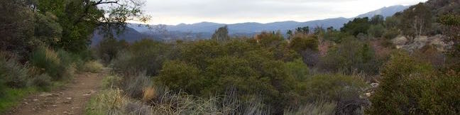
Horn Canyon Trail rises into the frontcountry of the Topatopa Mountains from Ojai, California. While you can spend a full day (and a full workout) hiking up Horn Canyon Trail, you can also opt for the shorter option described here, trekking up the trail's moderate opening mile, past multiple creek crossings and views down Ojai Valley, before venturing off trail up the canyon bottom past pools and a small cascade on Thacher Creek. ...Read more.
Distance: 2.9 miles · Elevation change: 750 feet
By: Published: March 31, 2017 Last updated: December 8, 2025
Oak Creek Canyon Loop Trail in Los Robles Open Space
Oak Creek Canyon Trail is a rather special trail in Los Robles Open Space that is designed for the blind as well as the sighted. The all-access nature trail has a dozen and a half signs in English and Braille. While blind hikers will probably want to turn around at the end of the guide fence, for a 0.55 mile hike with 50 feet of elevation change, others may continue on to a loop trail for a 0. ...Read more.
Distance: 0.8 miles · Elevation change: 100 feet
By: Published: March 10, 2017 Last updated: December 5, 2025
Vine Maple Trail – Old Wagon Trail – Oak Trail Loop in Tualatin Hills Nature Park
Surrounded by neighborhoods and business on the west side of Beaverton, Tualatin Hills Nature Park's 222 acres are a highly accessibly oasis of forests and wetlands. The relatively flat park has about twenty different trails covering 5 miles. You only need to utilize the park's main three trails, Vine Maple Trail, Old Wagon Trail, and Oak Trail to form an easy 2. ...Read more.
Distance: 2.1 miles · Elevation change: 30 feet
By: Published: March 7, 2017 Last updated: April 18, 2026
Two-Mile Loop in Tryon Creek State Natural Area
Located just five miles from downtown Portland, Tryon Creek State Natural Area preserves 658-acres of lush second-growth forest made up of mossy red cedars and Douglas firs. Many miles of trail and 8 bridges allow visitors to explore the Tryon Creek Watershed. At first glance, the web of trails on the park map is overwhelming, but it actually allows for numerous easy to moderate outings. ...Read more.
Distance: 2 miles · Elevation change: 150 feet
By: Published: March 3, 2017 Last updated: April 25, 2026
Trillium Trail in Tryon Creek State Natural Area
Want to learn about the native plants growing in Tryon Creek State Natural Area and elsewhere in the forests around Portland? Take an easy stroll (or roll a wheelchair) around Trillium Trail. This pair of paved loops is located next to Tryon Creek Nature Center and totals just 0.37 miles in length. Markers identify the green things growing along the trail and viewing decks peer into different layers of the forest to add insights to Trillium Trail. ...Read more.
Distance: 0.37 miles · Elevation change: 15 feet
By: Published: March 3, 2017 Last updated: December 5, 2025
Holman Lane – Wildwood Trail – Birch Trail Loop in Forest Park, Portland
Forest Park offers nearly instant access to the outdoors for people in Portland, Oregon. Pittock Mansions and the Stone House are popular destinations that can attract weekend crowds in Forest Park. For a quieter hike, combine Holman Lane, a section of Wildwood Trail, and Birch Trail for a 2.7-mile loop with 425 feet of elevation change. Holman Lane and Birch Trail leave NW 53rd Drive next to each other and connect to the major hiking trail through Forest Park to explore charming woodlands in the Tualatin Mountains (better known as the West Hills) Set out from the Birch Trailhead along NW 53rd Drive, which is half a mile from NW Cornell Road and offers ample parking. ...Read more.
Distance: 2.7 miles · Elevation change: 425 feet
By: Published: February 22, 2017 Last updated: April 18, 2026
Cedar Grove and Vista View Point in Griffith Park
Away from many of the tourists drawn to Griffith Park's great landmarks (like Griffith Observatory and the Hollywood Sign), you'll find locals enjoying views of their city from Vista View Point, also know as the helipad site. This overlook along Vista Del Valle Drive presents a broad perspective over downtown Los Angeles, Hollywood, and Griffith Park sites like the Greek Theater and the observatory. ...Read more.
Distance: 2.3 miles · Elevation change: 400 feet
By: Published: February 17, 2017 Last updated: April 9, 2026
Yurok Loop Trail & Hidden Beach in Redwood National Park
Up near the Oregon border, the north coast of California has beautiful unrefined features like driftwood-covered coves and mossy forests. Explore this inviting area on Yurok Loop Trail, a short hike through scenic surroundings. This 1.15-mile circuit passes an ocean vista along a dramatic coastline that faces a cluster of rock islands. The loop crosses a small wooded ridge, overlooking a lagoon. ...Read more.
Distance: 2.25 miles · Elevation change: 120 feet
By: Published: February 13, 2017 Last updated: December 5, 2025
Drury-Chaney Loop Trail in Humboldt Redwoods State Park
Drury-Chaney Loop Trail (also known simply as Drury-Chaney Trail) presents a easy and well graded hike through redwoods in Humboldt Redwoods State Park. The trail is a lollipop loop suitable for wheelchairs and strollers, crossing a surface of compact gravel with 100 feet of elevation change. The 2.4-mile length of this hike splits neatly into three sections: a 0. ...Read more.
Distance: 2.25 miles · Elevation change: 120 feet
By: Published: February 1, 2017 Last updated: April 8, 2026
Grieg-French-Bell Trail in Humboldt Redwoods State Park
Grieg-French-Bell Trail provides access to lovely grove of coast redwoods in Humboldt Redwoods State Park. The ground in this area is covered by a carpet of redwood sorrel that is incredibly beautiful to walk through. Within French Grove, you'll find the Girdled Tree, which had its bark removed to 1901 so that it could be displayed in San Francisco. ...Read more.
Distance: 0.5 miles · Elevation change: 25 feet
By: Published: January 18, 2017 Last updated: April 8, 2026