Terrace Hill Open Space hike San Luis Obispo California Terrace Hill Loop
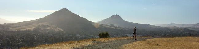
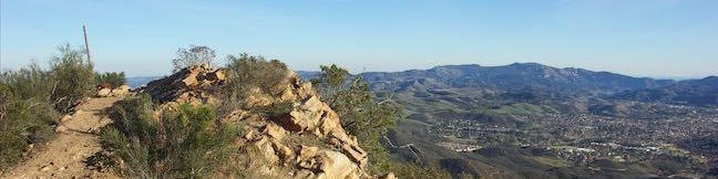
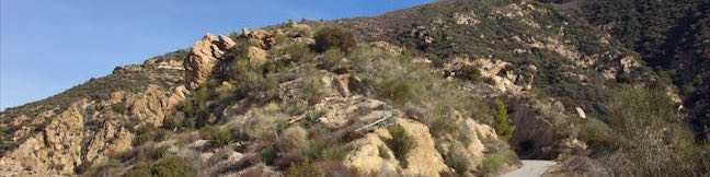
An interesting chain of conical volcanoes, or volcanic plugs called the Morros, graces San Luis Obispo County. Terrace Hill is one of the smaller and harder to identify Morros within the city of San Luis Obispo County. Unlike the other Morros, Terrace Hill has a broad flat summit. The top of the hill was removed for use as construction material in the 1920s, leaving behind a flat mesa-like... Read more.
OK! Add to trails I’ve hiked
OK! Add to trails I want to hike
Tagged with · Free Trails · Morros
Distance: 0.55 miles · Elevation change: 110 feet
By: Published: Last updated: April 2, 2019
Dixie Canyon Park Hike Sherman Oaks Santa Monica Mountains
Dixie Canyon Park preserves twenty tucked-away acres in the Santa Monica Mountains on the north side of the range west of Coldwater Canyon. The park can be accessed from Sherman Oaks for a micro hike that is 0.55 miles round trip with 175 feet of elevation change. This partial loop follows a dirt single track that is narrow and sometime overgrown, finding shade from walnut trees and coast... Read more.
By: Published: Last updated: January 14, 2019
Glendale Peak Hike Griffith Park Riverside Trail East Ridge Trail Henry's Trail to Glendale Peak Trail Los Angeles California
Mount Hollywood and Mount Lee might get the bulk of the summit-bagging hikers in Griffith Park, but Glendale Peak is a fine target of its own, hosting grand views of downtown Los Angeles, the San Gabriel Valley, and the San Gabriel Mountains. The 1,190-foot peak pokes out above the southeast side of Griffith Park at the end of a ridge that runs down from Mount Hollywood. Set out for Glendale... Read more.
OK! Add to trails I’ve hiked
OK! Add to trails I want to hike
Tagged with · Free Trails · Hollywood · Summits · Dog-Friendly Trails · Griffith Park · Santa Monica Mountains
Distance: 3.3 miles · Elevation change: 405 feet
By: Published: Last updated: December 7, 2018
Griffith Park Glendale Peak Mount Hollywood Loop Hike Griffith Park Los Angeles California
It is often said that two is better than one. Take a hike on Glendale Peak – Mount Hollywood Loop and you'll agree – two summits are better than one! Think of this Griffith Park hike like a meal with an appetizer and a main course. Glendale Peak is the appetizer, rising to 1,190 feet with tastier-than-expected views over southeast end of the park toward downtown Los Angeles and the San... Read more.
OK! Add to trails I’ve hiked
OK! Add to trails I want to hike
Tagged with · Free Trails · Hollywood · Summits · Dog-Friendly Trails · Griffith Park · Santa Monica Mountains
Distance: 4.15 miles · Elevation change: 765 feet
By: Published: Last updated: September 9, 2019
Strawberry Peak Trail San Gabriel Mountains Angeles National Forest Strawberry Peak Hike
Strawberry Peak holds the distinction of being the highest summit in the front range of the San Gabriel Mountains, besting nearby San Gabriel Peak by a just a yard. Measuring 6,164 feet tall, Strawberry Peak is taller than other surrounding mountains like Josephine Peak, Mount Lawlor, and Mount Wilson. A hike to the summit from Red Box Picnic Area on Angeles Crest Highway is 7.5 miles round... Read more.
By: Published: Last updated: September 9, 2019
Strawberry Peak Trail to Strawberry Meadow Hike San Gabriel Mountains National Monument Strawberry Potrero Angeles National Forest
Strawberry Meadow is an enticing area tucked away on the north side of Strawberry Peak below a massive granite cliff face. Walk into Strawberry Meadow and you might easily feel like you are somewhere in the Sierra Nevada Mountains, instead of hiking in the San Gabriel Mountains near Los Angeles. Find Strawberry Meadow next to a junction between Strawberry Peak Trail and Colby Canyon... Read more.
By: Published: Last updated: August 27, 2019
Josephine Peak Hike Colby Canyon Trail San Gabriel Mountains National Monument Angeles National Forest Josephine Saddle Josephine Peak Road
Want to hike to a mile-high summit in the San Gabriel Mountains with grand views over Los Angeles? Set your aim for Josephine Peak in the front range of the San Gabriel Mountains next to Strawberry Peak. Colby Canyon Trail offers a scenic route to the summit, traveling from Angeles Crest Highway up a withdrawn canyon to Josephine Saddle, a dip in the ridgeline west of Strawberry Peak. ... Read more.
By: Published: Last updated: August 29, 2019
Rattlesnake Flats Trail - Badger Trail - Bluff Trail Loop Montaña de Oro State Park Hike
Completely resurfaced to be wheelchair-friendly, the Bluff Trail in Montaña de Oro State Park is one of the most pleasant coastal trails in California. Once you have hiked the Bluff Trail, you will probably want to see it again (and again and again). Revisit the Bluff Trail and get just a bit more elevation by creating a loop with Bluff Trail, Badger Trail, and Rattlesnake Flats Trail. ... Read more.
OK! Add to trails I’ve hiked
OK! Add to trails I want to hike
Tagged with · California State Parks · Free Trails · Los Osos · Ocean Views · Tide Pools · Montaña de Oro State Park
Distance: 1.65 miles · Elevation change: 150 feet
By: Published: Last updated: May 11, 2017
China Flat Trail Simi Peak Trail Simi Hills hike Oak Park California China Flat Dead Cow Trail Suicide Trail Loop Oak Savanna
Looking up at the orange sandstone outcroppings on the rugged slopes of the Simi Hills, you would hardly expect the terrain above to host a peaceful oak savanna. Walk through this grassy area shade by tall oaks to ascend to Simi Peak, the highest point in a mountain range that spans the boundary between Ventura County and Los Angeles County just north of the 101 Freeway. Simi Peak is 2,403... Read more.
OK! Add to trails I’ve hiked
OK! Add to trails I want to hike
Tagged with · Conejo Valley · Free Trails · Oak Park · Simi Hills · Summits · Dog-Friendly Trails · Mountain Biking Trails
Distance: 6.2 miles · Elevation change: 1090 feet
By: Published: Last updated: August 29, 2019
Mount Lowe Road Sunset Ridge Trail to Cape of Good Hope Mount Lowe Railway Echo Mountain Ruins San Gabriel Mountains Hike Los Angeles National Forest California
Starting near the base of the San Gabriel Mountains in Altadena, Mount Lowe Road is an 8.9-mile long partially paved trail rising up the range to an intersection with Mount Wilson Red Box Road near the summit of Mount Wilson. Of course, you don't have to go that full distance on a hike up Mount Lowe Road. Sunset Ridge Trail intersects and parallels the bottom of Mount Lowe Road and is even... Read more.
By: Published: Last updated: August 27, 2019