Castle Lake Campground Shasta-Trinity National Forest Mount Shasta Camping
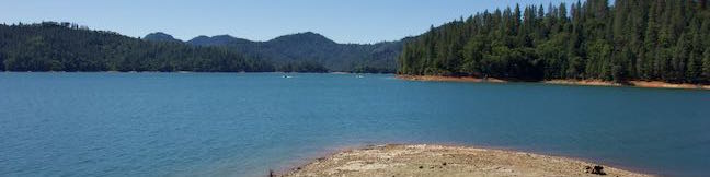
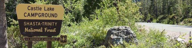
Find this cozy six-site campground set within a forest of pines and other conifers near Castle Lake, a beautiful glacial cirque lake in Shasta-Trinity National Forest. Castle Lake Campground makes a convenient base camp for hikes leaving from Castle Lake and the campground is a 20-minute drive from the city of Mount Shasta along Interstate 5. Castle Lake Campground The six sites at... Read more.
By: Published: Last updated: February 4, 2019
Castle Peak Hike Castle Peak Route Castle Peak Trail Heart Lake Hike Shasta-Trinity National Forest California
The short hike from Castle Lake to Heart Lake explores a scenic part of Shasta-Trinity National Forest near Mount Shasta. The fun doesn't need to stop once you reach that endearing lake. Hike off trail up a ridge from Heart Lake to a summit with extraordinary views that has been given the unofficial name of Castle Peak. You will feel like royalty when you stand on this mountaintop, taking... Read more.
OK! Add to trails I’ve hiked
OK! Add to trails I want to hike
Tagged with · Klamath Mountains · Lakes · Shasta-Trinity National Forest
Distance: 3.2 miles · Elevation change: 1180 feet
By: Published: Last updated: September 10, 2019
Heart Lake Trail Little Castle Lake Trail Heart Lake Hike Shasta-Trinity National Forest California
You are bound to fall in love with the hike to Heart Lake. This pint-sized heart-shaped attraction in the Castle Crags Wilderness of Shasta-Trinity National Forest boasts views of Mount Shasta, Black Butte, and surrounding Klamath Mountains. The hike to Heart Lake begins from a trailhead at Castle Lake, a larger mountain lake wrapped by pines and granite cliffs. For a two-lake trek, you can... Read more.
OK! Add to trails I’ve hiked
OK! Add to trails I want to hike
Tagged with · Klamath Mountains · Lakes · Shasta-Trinity National Forest
Distance: 2.9 miles · Elevation change: 645 feet
By: Published: Last updated: September 9, 2019
Oso Flaco Lake Trail Oceano Dunes SCRA Nipomo Dunes Hike San Luis Obispo California
Oso Flaco Lake Trail in Oceano Dunes SVRA offers a hike with easy-going appeal. The nearly level trail takes a boardwalk over a 75-acre birdlife-boasting lake and across sand dunes to a tucked-away beach and a viewpoint overlooking the Guadalupe-Nipomo Dunes. These are the largest dunes on the coast of Southern California, but Oso Flaco Lake Trail is a short hike at just 2-miles round trip.... Read more.
By: Published: Last updated: January 24, 2018
Arroyo Sequit Park Santa Monica Mountains National Recreation Area Arroyo Sequit Nature Trail
Take a trip to Arroyo Sequit Park to hike a short loop through a tucked-away pocket of the Santa Monica Mountains, The park is situated along Mulholland Highway inland of Leo Carrillo State Park and below the range's most rugged peaks. The surroundings for this 2.05 miles hike are beautiful. Arroyo Sequit Nature Trail has 285 feet of elevation change, winding over and around the upper... Read more.
By: Published: Last updated: December 7, 2018
Nicholas Flat Trail Willow Creek Trail Ocean Vista Hike Malibu Leo Carrillo State Park Scenic Loop hike Santa Monica Mountains
At the west end of Malibu where Mulholland Highway meets PCH, you'll find Leo Carrillo State Park. Well known for its beaches and surfing, this park has offerings for hikers too, like the trek up Nicholas Flat Trail to an oak-wrapped grassland with a small pond, which is 7 miles round trip or more. For a shorter hike, combine the bottom of Nicholas Flat Trail with Willow Creek Trail, for a... Read more.
OK! Add to trails I’ve hiked
OK! Add to trails I want to hike
Tagged with · California State Parks · Closed · Leo Carrillo State Park · Malibu · Ocean Views · Santa Monica Mountains
Distance: 2.05 miles · Elevation change: 620 feet
By: Published: Last updated: December 7, 2018
Nicholas Flat Trail Hike Malibu Leo Carrillo State Park Nicholas Flat Natural Preserve Santa Monica Mountains California
Nicholas Flat Trail is a three-mile long 'ocean to mountains' trail beginning within Leo Carrillo State Park, just across PCH from a famous beach at the west end of Malibu. The single-track trail travels up a coastal ridge past two vista points (and lots of other ocean views) to reach Nicholas Flat, where grassy meadows are rimmed by oak trees. A small network of trails offer different... Read more.
By: Published: Last updated: August 29, 2019
Antlers Campground Shasta-Trinity National Forest Shasta Lake Camping
Below pines and oaks beside Shasta Lake, you'll find Antlers Campground. The campground is conveniently located just off Interstate 5 between Redding and Mount Shasta, but you won't hear much freeway noise (actually you'll hear more noise from jet skies and boaters enjoying the Sacramento Arm of Shasta Lake). The shaded campground is spread out on a series of loops over level terrain that... Read more.
By: Published: Last updated: January 2, 2018
Bailey Cove Trail Shasta Lake Hike Shasta-Trinity National Forest California
Bailey Cove Trail follows an easy path that weaves along the edges of a roughly triangle-shaped peninsula extends into Shasta Lake. A hill rises over the center of the peninsula, which is framed by finger-like coves on two sides. Lake views are present throughout this 3.1-mile hike and are grandest during the second mile. Bailey Cove Trail is fairly level, with just 50 feet of elevation... Read more.
OK! Add to trails I’ve hiked
OK! Add to trails I want to hike
Tagged with · Lakes · Shasta-Trinity National Forest
Distance: 3.1 miles · Elevation change: 50 feet
By: Published: Last updated: April 23, 2017
Chumash Trail Crespi Trail Hutash Trail Loop Morro Bay State Park San Luis Obispo hike California Turri Road
While it is one of the more inland hikes in Morro Bay State Park, the loop formed by connecting Chumash Trail, Crespi Trail, and Hutash Trail delivers ample coastal views as it leads to a lovely grove of coast live oaks. This lollipop loop covers 2.9 miles with 420 feet of elevation change. Hutash Trail can be trimmed from the circuit to lower the round trip distance to 2.55 miles and... Read more.
OK! Add to trails I’ve hiked
OK! Add to trails I want to hike
Tagged with · California State Parks · Free Trails · Morro Bay · Morro Bay State Park · Ocean Views
Distance: 2.9 miles · Elevation change: 420 feet
By: Published: Last updated: January 11, 2018