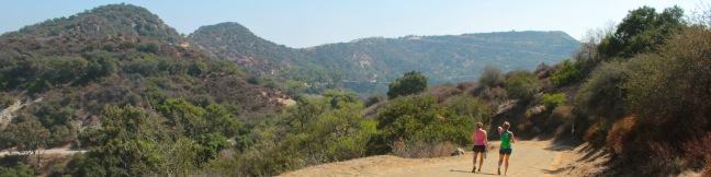
Gaviota Pass Overlook hike Gaviota State Park Trails Lompoc California
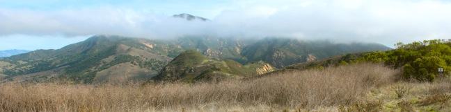
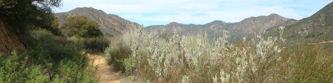
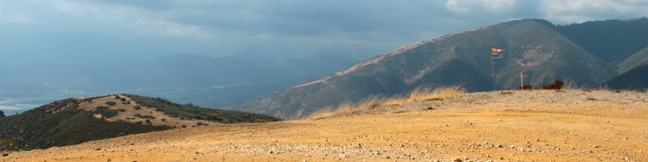
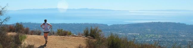
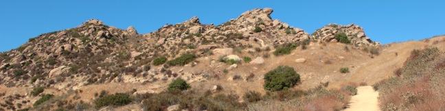
Gaviota State Park preserves 2,787 oceanfront acres in the rugged and beautiful Santa Ynez Mountains west of Santa Barbara. If the park was not sliced down the middle by Highway 101, it would surely be one of the most popular state parks on the Central Coast. The presence of the freeway certainly cuts down on crowds, enabling hikers to enjoy the largely untainted scenery in relative... Read more.
My Hikes IconAn green hiker icon marks the links to add this hike to your my hikes lists OK! Add to trails I’ve hiked
OK! Add to trails I want to hike
TagsA green icon depicting a tags represents a list of words and phrases that this content is tagged with Tagged with · California State Parks · Free Trails · Gaviota State Park · Goleta · Las Cruces · Ocean Views · Santa Ynez Mountains
Hike DistanceA green icon of a hiker used to label information about the length of the hike Distance: 6.5 miles · Elevation change: 650 feet
By: Published: Last updated: April 24, 2017
Fisherman's Camp Trail San Mateo Canyon Wilderness Santa Ana Mountains trail campground hike Tenaja Canyon
Once you break out of the trees at the trailhead, broad canyon views stay with you the way to Fisherman's Camp in the San Mateo Canyon Wilderness. Fisherman's Camp Trail descends 1.66 miles down what was once a road to what was once a campground nestled at the mouth of Tenaja Canyon. Grassy plots remain where backpackers can put up a tent in the shady creek-side retreat. Campfires are... Read more.
My Hikes IconAn green hiker icon marks the links to add this hike to your my hikes lists OK! Add to trails I’ve hiked
OK! Add to trails I want to hike
TagsA green icon depicting a tags represents a list of words and phrases that this content is tagged with Tagged with · Cleveland National Forest · Free Trails · Murrieta · San Mateo Canyon Wilderness · Santa Ana Mountains · Trabuco Ranger District
Hike DistanceA green icon of a hiker used to label information about the length of the hike Distance: 3.33 miles · Elevation change: 400 feet
By: Published: Last updated: September 10, 2018
Carbon Canyon Regional Park Redwood Grove Nature Trail to the Redwoods
Everyone knows that Northern California is the place to go to see groves of giant redwoods, but few people know that you can get a taste of the redwoods in Southern California. Carbon Canyon Regional Park in Brea has a 10-acre grove of coastal redwoods, the largest grove of these trees in Southern California. Even through the could-be giants are relatively young and not really suited for the... Read more.
My Hikes IconAn green hiker icon marks the links to add this hike to your my hikes lists OK! Add to trails I’ve hiked
OK! Add to trails I want to hike
TagsA green icon depicting a tags represents a list of words and phrases that this content is tagged with Tagged with · Brea · Carbon Canyon Regional Park · Nature Trails · Orange County Parks · Redwood Groves
Hike DistanceA green icon of a hiker used to label information about the length of the hike Distance: 2.5 miles · Elevation change: 75 feet
By: Published: Last updated: April 19, 2017
Ortega Falls Santa Ana Mountains Ortega Highway waterfall hike trail
How far would you be willing to hike to reach an idyllic swimming hole beneath a 35-foot waterfall - 5 miles, 10 miles? In fact, you will only have to hike a third of a mile round trip to reach Ortega Falls, a refreshing seasonal waterfall just off Ortega Highway in the Santa Ana Mountains. The hike begins from an unmarked turnout on Ortega Highway in a beautiful part of the Santa Ana... Read more.
My Hikes IconAn green hiker icon marks the links to add this hike to your my hikes lists OK! Add to trails I’ve hiked
OK! Add to trails I want to hike
TagsA green icon depicting a tags represents a list of words and phrases that this content is tagged with Tagged with · Cleveland National Forest · Free Trails · Lake Elsinore · Santa Ana Mountains · Trabuco Ranger District · Waterfalls
Hike DistanceA green icon of a hiker used to label information about the length of the hike Distance: 0.33 miles · Elevation change: 50 feet
By: Published: Last updated: January 15, 2018
Heart Rock Trail San Bernardino Mountains hike Crestline California Seeley Creek Falls heart shaped rock trail
How is it possible? How is it possible that a perfectly heart-shaped hole could form in the rock wall flanking Seeley Creek Falls? This amazing formation does exist and can be reached via a short, relatively easy one-mile round trip hike in the San Bernardino Mountains near the town of Crestline. The dirt trail to Heart Rock descends 200 feet, following Seeley Creek on a gradual... Read more.
My Hikes IconAn green hiker icon marks the links to add this hike to your my hikes lists OK! Add to trails I’ve hiked
OK! Add to trails I want to hike
TagsA green icon depicting a tags represents a list of words and phrases that this content is tagged with Tagged with · Crestline · Free Trails · San Bernardino Mountains · San Bernardino National Forest · Water Slides · Waterfalls
Hike DistanceA green icon of a hiker used to label information about the length of the hike Distance: 1.4 miles · Elevation change: 200 feet
By: Published: Last updated: January 9, 2018
Marshall Peak Trail San Bernardino Mountains summit California
The San Bernardino Mountains are a rugged east-west running mountain range in San Bernardino County east of the San Gabriel Mountains. While the range tops out at the 11,500-foot summit of San Gorgonio Mountain, you can find great panoramic view from a 4,000-foot peak that is much easier to reach. Marshall Peak rises above the foothills of the mighty San Bernardino Mountains and is just a... Read more.
My Hikes IconAn green hiker icon marks the links to add this hike to your my hikes lists OK! Add to trails I’ve hiked
OK! Add to trails I want to hike
TagsA green icon depicting a tags represents a list of words and phrases that this content is tagged with Tagged with · Adventure Pass · Crestline · San Bernardino · San Bernardino Mountains · San Bernardino National Forest · Summits
Hike DistanceA green icon of a hiker used to label information about the length of the hike Distance: 3.25 miles · Elevation change: 375 feet
By: Published: Last updated: May 19, 2024
Jesusita Trail to Inspiration Point hike Santa Barbara California
Located in the Santa Ynez Mountains, 1,800-feet above Santa Barbara, Inspiration Point provides panoramic views over The American Riviera. It is a moderate 7.55 to 7.95-mile round trip trek from San Roque Road up Jesusita Trail to Inspiration Point, gradually checking off 1,400 feet of elevation gain. Those who prefer a shorter alternative, can hike from Tunnel Road and take a 3.75-mile... Read more.
My Hikes IconAn green hiker icon marks the links to add this hike to your my hikes lists OK! Add to trails I’ve hiked
OK! Add to trails I want to hike
TagsA green icon depicting a tags represents a list of words and phrases that this content is tagged with Tagged with · Creeks · Free Trails · Ocean Views · Santa Ynez Mountains
Hike DistanceA green icon of a hiker used to label information about the length of the hike Distance: 7.55 miles · Elevation change: 1800 feet
By: Published: Last updated: January 9, 2018
Rocky Peak Park summit hike Simi Valley Los Angeles California
Rocky Peak is a panoramic 2,715-foot summit on the border between Los Angeles and Ventura counties in the Santa Susana Mountains. The county line-straddling peak stands at the center of a 4,800-acre park bearing the same name. The shortest hike to Rocky Peak takes Rocky Peak Trail from Rocky Peak Road through Rocky Peak Park. Oh boy, we're off to a rocky start... The first two miles of... Read more.
My Hikes IconAn green hiker icon marks the links to add this hike to your my hikes lists OK! Add to trails I’ve hiked
OK! Add to trails I want to hike
TagsA green icon depicting a tags represents a list of words and phrases that this content is tagged with Tagged with · Free Trails · Mountains Recreation and Conservation Authority · Santa Susana Mountains · Simi Valley · Summits · Wind Caves · Dog-Friendly Trails · Mountain Biking Trails
Hike DistanceA green icon of a hiker used to label information about the length of the hike Distance: 4.75 miles · Elevation change: 900 feet
By: Published: Last updated: December 7, 2018
Amir's Garden trail Griffith Park hike Los Angeles
Amir's Garden is no mere garden; it's one of two unique and awesome picnic areas on the east side of Griffith Park. The most surprising place for a picnic is probably the Old Zoo Picnic Area, where you can dine alongside old animal pens. Amir's Garden is the most pleasant place for a hike-in picnic, with a selection of picnic tables surrounded by a volunteer-supported sanctuary of flowering... Read more.
My Hikes IconAn green hiker icon marks the links to add this hike to your my hikes lists OK! Add to trails I’ve hiked
OK! Add to trails I want to hike
TagsA green icon depicting a tags represents a list of words and phrases that this content is tagged with Tagged with · Free Trails · Picnic Area · Dog-Friendly Trails · Griffith Park · Santa Monica Mountains
Hike DistanceA green icon of a hiker used to label information about the length of the hike Distance: 1 mile · Elevation change: 275 feet
By: Published: Last updated: December 7, 2018
Mount Hollywood, Mount Bell, and Mount Chapel hike peaks trails Griffith Park summit trek Griffith observatory hike
If you're interested in getting some exercise with panoramic views over Griffith Park, consider hiking a loop to the summit's of three park peaks: Mount Chapel, Mount Bell, and Mount Hollywood. Starting from Hollyridge Trail at the top of Beachwood Drive, this 5.7-mile loop ascends 675 vertical feet, from 950 feet at the trailhead to 1,625 feet at the summit of Mount Hollywood, the... Read more.
My Hikes IconAn green hiker icon marks the links to add this hike to your my hikes lists OK! Add to trails I’ve hiked
OK! Add to trails I want to hike
TagsA green icon depicting a tags represents a list of words and phrases that this content is tagged with Tagged with · Free Trails · Hollywood · Summits · Dog-Friendly Trails · Griffith Park · Santa Monica Mountains
Hike DistanceA green icon of a hiker used to label information about the length of the hike Distance: 5.7 miles · Elevation change: 675 feet
By: Published: Last updated: May 13, 2025