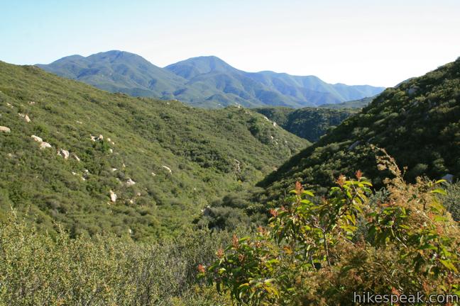
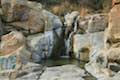
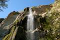
How far would you be willing to hike to reach an idyllic swimming hole beneath a 35-foot waterfall – 5 miles, 10 miles? In fact, you will only have to hike a third of a mile round trip to reach Ortega Falls, a refreshing seasonal waterfall just off Ortega Highway in the Santa Ana Mountains.
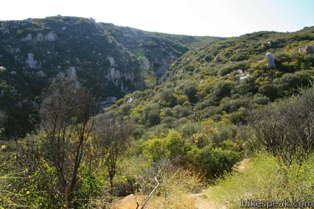
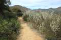
The hike begins from an unmarked turnout on Ortega Highway in a beautiful part of the Santa Ana Mountains that is protected by the Cleveland National Forest. Ortega Falls is on the west side of Riverside County close to the Orange County border. Take the path down into the ravine below Ortega Falls. The top of the waterfall should be visible from the start.
When a path to the right presents itself, seize the opportunity to avoid dropping all the way down to the creek, which would lead to a more arduous approach to Ortega Falls. Instead, go uphill along the lip of the canyon on a dirt and rock trail headed straight to the base of the falls.
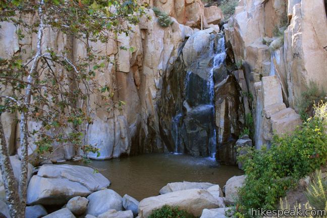
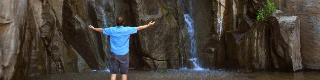
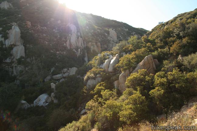
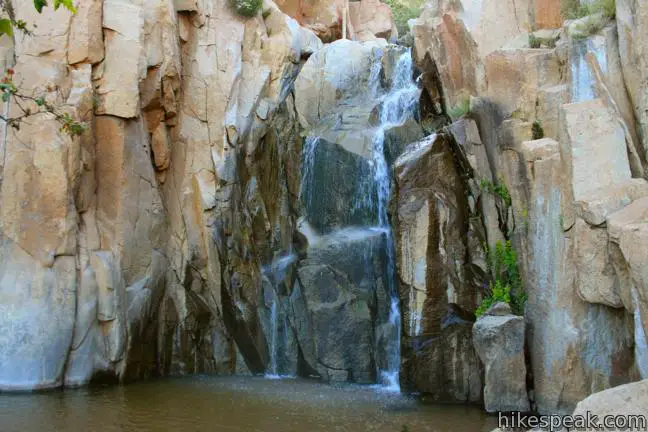
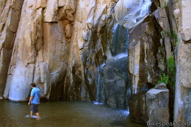
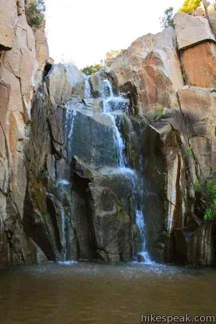
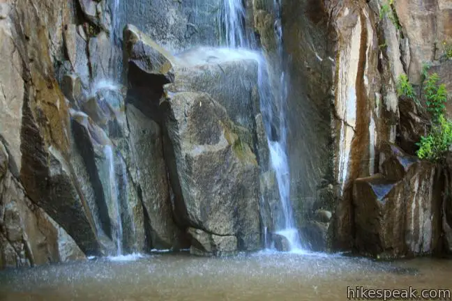
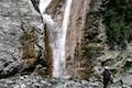
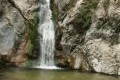
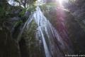
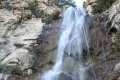
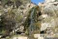
Less than quarter mile from the start, you will arrive at a rock amphitheater enclosing the 35-foot Ortega Falls. Unlace your hiking shoes and slip into the shallow sandy pool beneath the falls. On a hot day, there is nothing as refreshing as a shower beneath the waterfall.
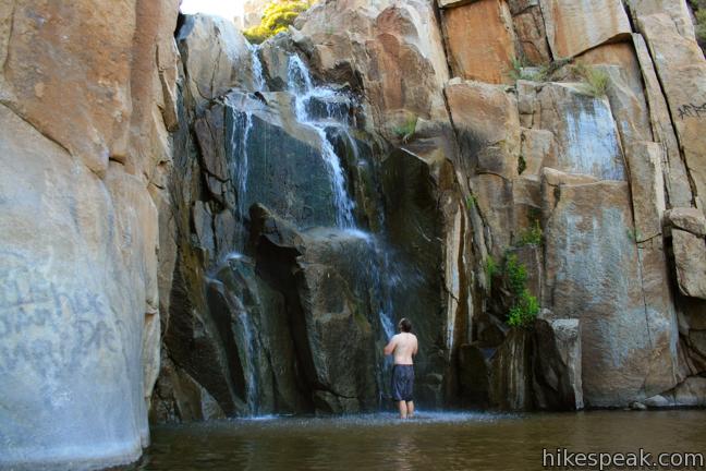
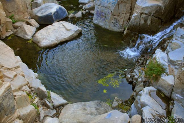
Below the Ortega Falls there is a cascade of about the same height as the waterfall. At its base you will find a deep pool that is inviting for swimmers. Ortega Falls is a refreshing swimming hole in the spring but typically runs dry in summer and fall. When the seasonal waterfall disappears, the remaining dry falls is enjoyed by rock climbers.
It is about a third of a mile round trip to Ortega Falls with 50 feet of elevation change. No permit is required to hike to Ortega Falls, and it is free to park at the trailhead (a National Forest Adventure Pass is no longer required). Dogs are welcome, so get out and enjoy!
Directions to the Trailhead
- Take Route 74 (Ortega Highway) to an unmarked turnout on north side of the road, 1.5 miles north of Ortega Oaks Candy Store and two miles south of El Cariso Visitor Center, where El Cariso Nature Trail begins.
- It is 12 miles to the trailhead from the 15 Freeway in Lake Elsinore to the east and 21 miles from the 405 Freeway in San Juan Capistrano to the west.
Trailhead Location
Trailhead address: Ortega Highway, Cleveland National Forest, Lake Elsinore, CA 92530
Trailhead coordinates: 33.625765, -117.426339 (33° 37′ 32.75″N 117° 25′ 34.82″W)
You may also view a regional map of surrounding Southern California trails and campgrounds.


 | El Cariso Nature Trail This 1.35 to 1.55-mile loop examines common plants in the Santa Ana Mountains, along with uncommon views views across the mountain range, passing an old mine for more fun. |
 | Tenaja Falls This 1.5-mile round trip hike ventures up a wilderness canyon to a tall, five-tier waterfall along San Mateo Creek in the Santa Ana Mountains. |
 | Fisherman's Camp This 3 1/3-mile round trip hike follows an old road to an old campground with views over San Mateo Canyon in the Santa Ana Mountains. |
 | More hikes in Southern California Explore more trails in Orange, Riverside, San Bernardino, and San Diego counties. |
 | San Antonio Falls This 1.4-mile hike visits a multi-tier waterfall along the trail to Mount Baldy. |
 | Eaton Canyon Falls This 3.5-mile hike goes up Eaton Wash to a narrow stretch of Eaton Canyon containing a pleasant 40-foot waterfall. |
 | Trail Canyon Falls This 4-mile hike ascends a mountain-framed canyon to a 30-foot beauty on the east side of the San Gabriel Mountains. |
 | Escondido Falls This 3.8-mile out and back hike visits a 200-foot waterfall that is split into two tiers. The upper tier is 150 feet tall and stunning after a rainstorm. |
 | Rose Valley Falls in the Los Padres National Forest This 1-mile round trip trail leads to the lower tier of a lovely two-tier 300-foot waterfall. |
 | Tangerine Falls in Los Padres National Forest This 2.5-mile hike visits a beautiful waterfall on the edge of Santa Barbara. |
 | More waterfalls around Los Angeles Explore other waterfalls in the Santa Monica and San Gabriel Mountains. |
 | El Cariso Campground This 24-site campground in Cleveland National Forest offers convenience camping in the Santa Ana Mountains for $15 per night, with access to nearby trails like El Cariso Nature Trail. |
- Ortega Falls on greeneadventures.com (opens in a new tab)
- Ortega Falls on world-of-waterfalls.com (opens in a new tab)
- Ortega Falls on Brian and Ashley's hiking blog (opens in a new tab)
- Ortega Oaks Candy Store on Ortega Highway (opens in a new tab)
- The official website for Cleveland National Forest (opens in a new tab)
Common Questions about Ortega Falls in the Santa Ana Mountains
- Is the trail open?
- Yes. You should expect to find that Ortega Falls Trail is open. There are no recent reports of trail closures. If you discover that the trail is closed, please help your fellow hikers by reporting a closure.
- Is this trail free to access?
- Yes, Ortega Falls Trail is free to access. No entrance fee, pass, or permit is required. If you discover that access rules have changed, please provide feedback on your experience.
- How much time does this hike take?
- It takes approximately 15 minutes to hike Ortega Falls Trail. Individual hiking times vary. Add extra time for breaks and taking in the views.
- How long is this hike?
- The hike to Ortega Falls Trail is a 0.33 mile out and back with 50 feet of elevation change.
- Are dogs allowed on this trail?
- Yes, dogs are allowed on Ortega Falls Trail. The trail is open to hikers, dogs.
- Is Ortega Falls Trail good for kids?
- Yes, this hike is likely suitable for children. It is relatively short (0.33 miles) with manageable elevation gain.
- Will I see a waterfall on this hike?
- Yes, Ortega Falls Trail features a waterfall.
- What mountain range is this trail in?
- Ortega Falls Trail is located in the Santa Ana Mountains.
- Where is the trailhead located?
- The trailhead for Ortega Falls Trail is located in Lake Elsinore, CA.
Trailhead Address:
Ortega Highway
Lake Elsinore, CA 92530
Trailhead Coordinates:
33.625765, -117.426339 - What are the driving directions to the start of the hike?
To get to the trailhead: Take Route 74 (Ortega Highway) to an unmarked turnout on north side of the road, 1.5 miles north of Ortega Oaks Candy Store and two miles south of El Cariso Visitor Center, where El Cariso Nature Trail begins. It is 12 miles to the trailhead from the 15 Freeway in Lake Elsinore to the east and 21 miles from the 405 Freeway in San Juan Capistrano to the west.
View custom Google Maps directions from your current location.
- Are there other trails near Ortega Falls Trail?
- Yes, you can find other nearby hikes using the Hikespeak Hike Finder Map.

26 Comments on Ortega Falls in the Santa Ana Mountains
What hikers are saying:
✨ Generated summary of user commentsHikers find this trail to be a refreshing escape when the water is flowing, particularly enjoying the multiple falls and pool areas. Shane recommends staying to the right to reach the largest waterfall and continuing upward for expansive views. Visitors must be prepared for significant litter and vandalism, as spray paint and trash frequently mar the natural beauty of the rocks.
Is the water swimable 6/8/2013?
When it’s there, it is cold and refreshingly fine. We just need a good storm to get it rolling. There are also 2-3 falls both above and below the main one. It’s fun place to hike even in the dry season. Nice to know you no longer need a pass. This is my favorite highway break spot.
Does anyone know if the falls have dried up for the year?
Yes, but still a great place to visit. I stopped for a quick hike to the top and on the way out met a lady who looked like she was heading for some sun.
Wait for the next major rain storm and then check out the waterfall. Meanwhile, I hear that Eaton Canyon Falls runs year round.
Ortega Falls looks fun!
I went today for the first time and it was dry. Had the place to myself aside from two rock climbers. It is a peaceful, beautiful place. There is some trash people have left behind, unfortunately.
when is the waterfall dried up, or how can we know if it is dried up or not?
They are there still went on sunday
Do u need an adventurous pass? As of march 29,2017
Nope
Is there still water?
Yes! Went today. 5/1/17
Is it toddler or stroller friendly?
Nope. This trail is too rugged for a stroller.
Awesome hike…. Waters very refreshing. My wife hates hiking and loved it!! There are 3 main falls and 2 pool areas. Stay to the right to get to the largest fall. Trail continues up above for great views.
What would the weather be like to hike this in the first week of December?
Does anyone know if there is water running or at the base right now?
You should certainly find water at the waterfall this time of year.
Has anyone been there in the last few days? Is there water?
Waterfall is dried up as of 7/18/2018
Is there water to swim now
Does any one know if there is any water ?
Planning to hike on 4th of July?
Did anyone visit this trail recently ..
Is there water here?
Is it deep enough to actually go swimming or is it more for kids to walk in?
So beautiful except what people have done. A lot of the rocks are tagged with spray paint. Used condoms everywhere on the trail. Yuck. Beer bottles and cans abound. If you’re a litterbug stay away, please. Too bad it is so messed up.
where does the water come from to make the Ortega water falls