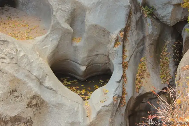
How is it possible? How is it possible that a perfectly heart-shaped hole could form in the rock wall flanking Seeley Creek Falls? This amazing formation does exist and can be reached via a short, relatively easy one-mile round trip hike in the San Bernardino Mountains near the town of Crestline.
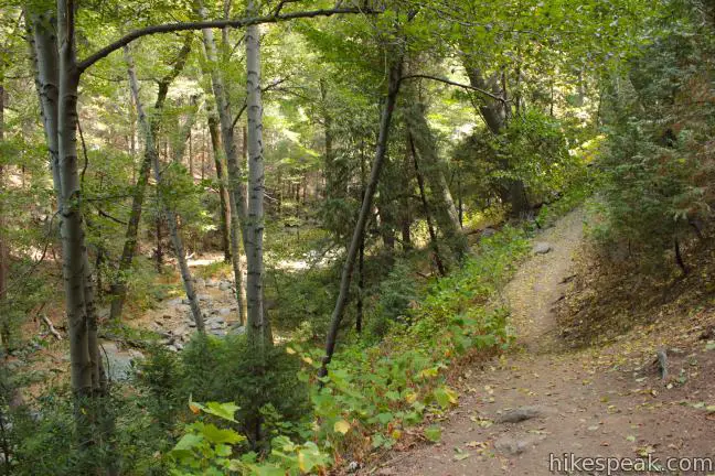
The dirt trail to Heart Rock descends 200 feet, following Seeley Creek on a gradual northward descent through a mountain forest of black oaks and Jeffrey pines. At 0.3 miles from the trailhead, the trail drops close to the creek at a junction with a path breaking off to the right down to babbling water shaded by tall alders. Stay to the left to continue toward Heart Rock. There are blue hearts and arrows painted onto rocks along the trail to keep you on course.


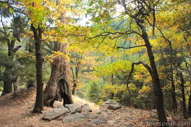
After half a mile of hiking along the sylvan stream, the trail climbs to a landing where a large dead pine will attract your attention. Heart Rock Overlook is near! If you find yourself going down a steep narrow path, you missed the trail to the overlook. Beyond the landing, the steep path drops to the creek where you can find a natural water slide (when the water is flowing) just below Seeley Creek Falls. Venture upstream to the base of the 20-foot waterfall for a non-optimal perspective of Heart Rock.

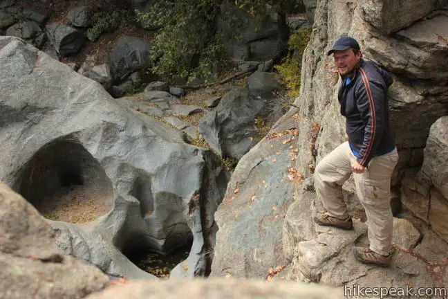
The best view of Heart Rock comes from the overlook. When you reach the landing by the big hallow tree trunk, stay to the right, following the painted signs down to an outcropping above the waterfall. Be cautious as you peer over the ledge’s edge at the perfectly carved and completely natural heart-shaped hole in the granite wall alongside the waterfall. The heart is a few feet wide, a couple feet deep, and surprisingly symmetrical.

Spring and summer are a popular time to visit Heart Rock when Seeley Creek flows and the waterfall gushes. The trail remains enjoyable even when the creek dries out in late fall as autumn colors appear, brightening the black oaks along the trail. This short trail is good for children who can spend hours playing in the creek (but watch them closely on the overlook above Seeley Creek Falls). No permit is required to hike to Heart Rock, and it is free to park at the trailhead (a National Forest Adventure Pass is no longer required). Dogs are welcome, so get out and enjoy!
To get to the trailhead: From the 210 Freeway in San Bernardino, take exit 76 for Waterman Avenue (Highway 18). Drive north on Waterman Avenue, which leaves the city after 2 miles and becomes Rim of the World Highway. At 11.3 miles from the 210 Freeway, take the exit ramp onto Route 138 West. Drive 2.6 miles through Crestline and the Valley of Enchantment to the entrance of Camp Seeley. Turn left on Forest Service Road 2N03, pass the camp and follow the dirt road across Seeley Creek and over a rise to the trailhead, 0.4 miles from Route 138 where the dirt road becomes gated. The trail to Heart Rock begins next to a marker labeled 4W07.
Trailhead address: Route 138, San Bernardino National Forest, Crestline, CA 92325
Trailhead coordinates: 34.257, -117.305862 (34° 15′ 25.2″N 117° 18′ 21.1″W)
You may also view a regional map of surrounding Southern California trails and campgrounds.
 | Marshall Peak This 3.25-mile round trip hike reaches a panoramic summit above the foothills of the San Bernardino Mountains. |
 | Heaps Peak Arboretum Take a short hike on Sequoia Trail and Footprint Trail to learn about the plants, animals, and natural history of the San Bernardino Mountains. |
 | Towne Trail This 2 2/3-mile round trip hike takes a gradual course across the mountains on the south side of Big Bear Lake. |
 | More hikes in Southern California Explore more trails in Orange, Riverside, San Bernardino, and San Diego counties. |


Does anyone know if a pass is required for this area?
According to this San Bernardino National Forest webpage, an adventure pass is no longer needed to park at this trailhead.
Thanks!
I was wondering if the trail is walkable now..is there snow?
Hey me and my fiancé went there today nov 4 2018 it is an awesome trip I am an experienced hiker once you find the heart rock be really careful going down the rocks it is about 70 feet down but easily accessible on foot make the trip take some friend you’ll be glad you did and yes the trail in is in great shap I give this location 9 out of 10 ???Enjoy your trip
Approximately how long is the hike?
This hike is half a mile each way, so it will only take about half an hour to complete.
Our family is thinking about taking a fall outing to this area & just confirming – at this time, was wondering if you still don’t need an Adventure Pass for this location? I see you mentioned there is free parking at the trail head. I would imagine there aren’t spots, just parking on the side near the trail head? Thanks so much for your time.
Just wanted to say ‘thank you’ for the awesome post about the hike. I found it online yesterday morning and we went hiking to the heart yesterday afternoon. It was spectacular
The hike was exactly what I read. Of course, I did not tell my husband at first, so he thought it was a lucky find. I came clean when we reached the waterfall and saw the heart. We took lots of photos and had a fabulous day.
p.s. to Julie, we found parking at the trail head for several cars. There was only one other car when we parked and we saw three parties of hikers along the way,
Just confirming now that its 2015, is a pass needed for the parking? Want to take my family there for a Valentine Day picnic <3
You should not need one. Have a good hike.
You see a heart, but when I look at the entire rock formation surrounding the “heart” (image 21) – all I can see is a skull.
I see it now too. Great observation!
Do not park in camp seely you will be towed
they didnt tow us but we were only there for an hour
I’m nervous about visiting waterfalls in Southern California during such a drought as we’re having – is this water fall currently running or is it mostly dried up? I can’t seem to find any current photos of it since 2010.
Yes, all the streams and waterfalls are running really dry.
Can I take a stroller on the trail?
No, unless it has some serious off-road wheels on it?
Can you park an RV near heart rock if wanting to attempt this hike on our road trip through California?
been there just last week and it looked liked a Tsunami rushed in there. Went hiking there in Feburary and it looked fairly nice. The second time wasn’t too bad still looked the same, the water levels weren’t too bad. The third time we went to hike it looked like a Tsunami washed Big boulders, Rocks, and even ripped trees off its roots laying just about everywhere throughout the whole trail. The water levels the third time around were lowered big time compared to the first two times i hiked there this year. Its a good hike for the family and friends as you don’t have to climb anything drastic.
[…] sister-in-law asked us if we wanted to go for a hike to a place called “Heart Rock.” Just the name itself got me very interested and when I saw photos on the internet of this […]
did the fires affect this area, my lady and i want to hike here tomorrow
some of the trees looked burned but its a great hike still alot of trees and pretty rocks.
Can you tent camp there?
I don’t think so. There really isn’t a place for that there
probabbly not. the camp is closed down.pull to the side of the road and hike it in the daytime.
Just went here today it was so beautiful & peaceful. Waterfalls everywhere it was nice and cool fresh air, but I do recommend wearing a bug repellent lots of mosquitoes, flies etc.
do you need a photography permit here?
My name is Michael asper I grew up going to heart rock in voe I miss the mountains
Are dogs allowed on the trail?
Yes.
Curious about the drive up there. I know the roads can be icy sometimes. How can i be aware if i need chains on my wheels or when to avoid the icy roads ?
Chain control is set up on the main highway. You can also look up “current road conditions for..” any specific highway on the internet.
Is there a time curfew? what days are open and close?
best to do this in the daytime as there is alot of rocks slide areas and the trails are narrow.
Its a nice place to hike and get some exercise some of the trees were burned looked like lightening maybe i dont know. Didn’t see any wildlife accept for birds.
[…] followed the directions from hikespeak.com, but of course, once we arrived at the destination we saw that the gate was closed and kept […]
[…] The overlook to see Heart Rock can be a bit tricky to find – I found this guide to give the most in-depth instructions on how to get to it. It will be on the right hand side of the trail, and you need to go slightly off the main path and then walk in the opposite direction to see it. That said, I’ve been able to find it without instructions, and if other groups are around, they’ll be able to point you in the right direction […]