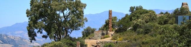
In the mountains above Santa Barbara, a plot of privately owned land surrounded by the Los Padres National Forest. On that land stand the remains of a palatial estate that burned down seventy years ago, the so-called Knapp’s Castle. To the ruins and back is a 0.8-mile round trip hike with 50 feet of elevation change. The majestic views from this unique spot far exceed the effort.
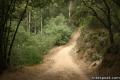
From East Camino Cielo at an elevation of 2,900 feet, take an unmarked dirt road down the north side of the mountain. After a quarter mile, as Knapp’s Castle comes into view, turn right, passing through a gate to reach the ruins.
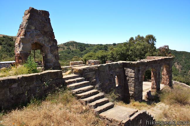
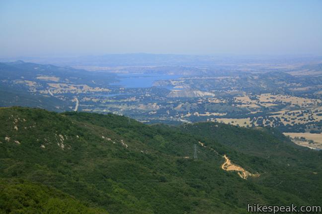
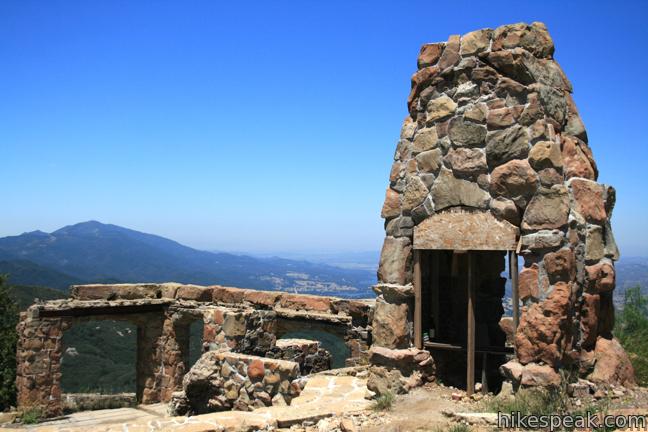
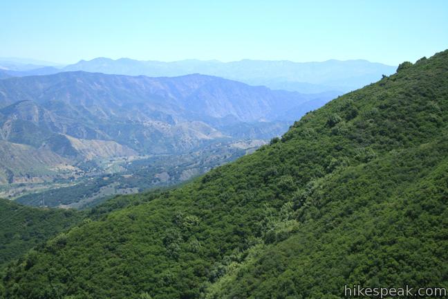
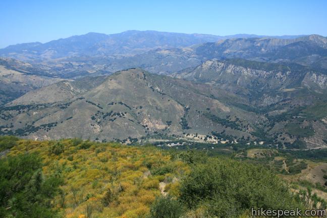
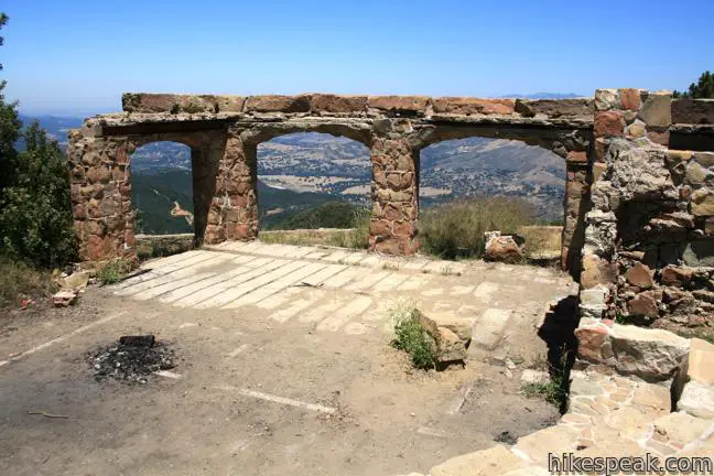
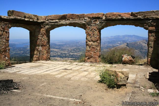
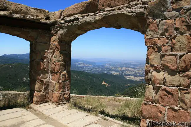
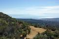
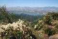
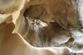
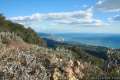
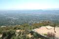
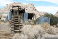
Stride down the imperial landing overlooking the Santa Ynez River Canyon, Lake Cachuma, and the opposing peaks of the San Rafael Mountains. Explore the enduring remains of Knapp’s Castle, which include stone steps, archways, and fireplaces. Several pieces still stand from the impressive home built in 1916 for George Knapp, a former chairman for Union Carbide.
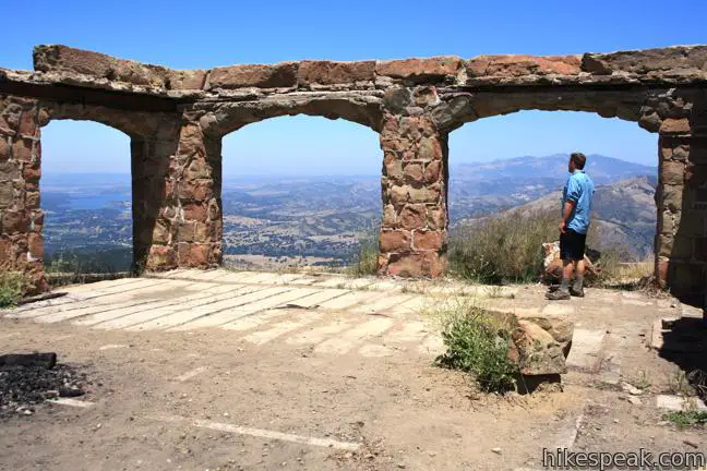
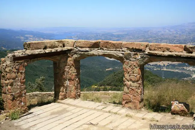
Look northwest through a trio of stone arches toward Lake Cachuma, a reservoir that did not exist when Knapp’s Castle was built or burned. While the view has certainly changed, this is still a breathtaking place to build a home or take a hike. When you have finished checking out the ruins, return the way you came.
In 2011, a construction notice was posted at the trailhead. This alarmed the local hiking community, which has enjoyed longstanding access to the privately owned ruins. According to the Santa Barbara Independent, the Santa Barbara County Planning Department issued a “stop work” order on any construction at Knapp’s Castle at the beginning of 2011. Based on the posted notice, it is possible that changes to the ruins could come in the future.
Hike to Knapp’s Castle while you can. No permit is required to visit the ruins. You may need to display a National Forest Adventure Pass to park a vehicle to park at the trailhead.
To get to the trailhead: From Highway 101 in Santa Barbara, take Route 154 north for ten miles. At the top of the mountain, turn right on East Camino Cielo and drive three miles east to a small turnout on the right opposite the gated dirt road on the left (the start of the trail). The trailhead is located on a C-shaped bend in East Camino Cielo, one mile past Painted Cave Road, the turn off for Chumash Painted Cave State Historic Park.
Trailhead address: East Camino Cielo (Forest Route 5N12), Los Padres National Forest, Santa Barbara, CA 93105
Trailhead coordinates: 34.518155, -119.793234 (34° 31′ 05.35″N 119° 47′ 35.64″W)
You may also view a regional map of surrounding Central Coast trails and campgrounds.


 | Chumash Painted Cave This very short trail looks in on Native American rock art in the Santa Ynez Mountains. |
 | Lizard's Mouth This half-mile hike visits a unique rock formation with amazing views over Santa Barbara and the Pacific. |
 | Inspiration Point from San Roque Road This 7.55 to 7.95-mile round trip hike ascends 1,400 feet up the western side of Jesusita Trail to a panoramic perch in the Santa Ynez Mountains with great views over Santa Barbara. |
 | Inspiration Point from Tunnel Road This 3.75-mile round trip combines Tunnel Trail and Jesusita Trail to ascend Mission Canyon to a sweeping viewpoint that looks down over Santa Barbara and up into the Santa Ynez Mountains. |
 | Tequepis Trail This invigorating 8.4-mile round trip hike offers views of Lake Cachuma as it climbs the Santa Ynez mountains to views of Santa Barbara and the Pacific. |
 | Nojoqui Falls This short 0.65-mile hike visits an 80-foot tall fern-lined waterfall. |
 | Gaviota Peak This 6.5-mile loop mounts a 2,458-foot summit two miles from the Pacific and then descends Trespass Trail to explore the wilds of the Santa Ynez Mountains. |
 | Gaviota Wind Caves This 2.5-mile hike just off Highway 101 visits wind-carved caves in Gaviota State Park with great ocean views. |
 | Tangerine Falls This 2.5-mile hike visits a beautiful waterfall on the edge of Los Padres National Forest near Santa Barbara. |
 | Montecito Peak This 7.1-mile partial loop climbs to a panoramic summit in Los Padres National Forest overlooking Montecito and Santa Barbara. |
 | McMenemy Overlook This 3.7-mile hike uses four trails to form a loop through the mountains behind Montecito, California. |
 | More Central Coast Hikes Explore other destinations along the California coast between Ventura and Monterey, including trails in Los Padres National Forest. |
 | Solstice Canyon This easy and level 2.6-mile out and back hike visits the ruins of a burned down ranch and a small waterfall. |
 | Murphy Ranch in the Santa Monica Mountains This 3.85-mile loop descending from Sullivan Ridge Fire Road into Rustic Canyon by abandoned buildings that had unusual occupants. |
 | Echo Mountain in the San Gabriel Mountains This 5.8-mile hike visits a historic railway and ruins from a century old resort overlooking Pasadena. |
 | Wall Street Mill in Joshua Tree National Park This level 1.55 to 2.15-mile hike visits a well-reserved gold mill, exploring the mining history of Joshua Tree National Park. |
This hike to Knapp castle is still valid. Construction has stopped
House is in process and big. Uses the old arches for the patio. You still can access the arches.
Is there any way of contacting the owner of the property to make sure it is okay with him/her if we hike all the way up to the castle? I don’t want to get arrested for trespassing.
Does anyone know is Knapp’s Castle is open as of July 2013?! My finace and I are headed to the area and would love to make the hike! Any information would be so very appreciated! I keep seeing mixed signals about wether it’s open or closed…
are we allowed to hike all the way up to the ruins? how do we get a national forest adventure pass? are we allowed to take pictures at the ruins? because i want to get a few photos for my senior portraits done here! please let me know!!!! any info is greatly appreciated!!!
Due to some new regulations, you probably do not need an adventure pass to park at the trailhead. I believe the trail is still open to the public.
Is there any information on access to this as of now?
Hiked it yesterday. Still open to public!
Do you still need an adventure pass?
Good question. Probably not, unless they’ve added a toilet at the trailhead or developed it in another way.
I just got back from the mountain and it is AMAZING!! From the bottom to the top was about 3.7 miles of steep incline…so exausting but well worth it. It is open to the public and there is contact information at the top about camping on the property…..bring lots of water and good luck if you are starting from the bottom………
[…] information: Trip descriptions here […]
[…] Knapp’s Castle East Camino Cielo (Forest Route 5N12) Los Padres National Forest Santa Barbara, CA 93105 […]
I loved it here! It was really peaceful. I made a little video with the video shots I got!
https://www.youtube.com/watch?v=_AdNX_NVlvo
[…] views of the mountains or a spectacular sunset. If you want a bit of a challenge, try to find the Knapps Castle trail in the Los Padres national forest. Panoramic views and an adorable photo-op among the […]
What is the current phone number to get a hiking pass to visit Knapps Castle? I am aware that people also need to book photoshoots before assuming it is free! This is a private property afterall. Thank you
I too am looking for any contact info for Knapp’s Castle. I was told it’s the number for a groundskeeper who overlooks the trail but have yet to be able to find any way to contact him…
Trail still open, no pay or pass required. Beware, our car was broken in to while there.
Construction has resumed on the property. It seems while the work is in progress, the property will still be accessible to the public. Once it is completed however, it will be gated off. A new black iron gate has been erected on both sides of the dirt road leading up to it. There is a lot of broken glass on and near the construction sight so dog walkers please beware. I highly recommend visiting the castle while you can!
[…] Knapp’s Castle Thousands of people drive by this place and don’t even know it’s here, but less than half a mile off of East Camino Cielo, you’ll find the ruins of an estate owned by the Knapp family. The trail to the “castle” is relatively flat and easy to access, and if you have kids along, they’ll have a blast climbing over the walls and foundations to explore this site. Be sure to bring your camera because the views of the lake and river canyon are pretty awesome. Free. […]
Knapp’s Castle is no longer an attraction for the area. The hike is now basically just the driveway to a private house, where you encounter a fence if you walk down it..
Went yesterday. It is CLOSED. We spoke with the construction workers who wee leaving for the day and they told us it was no longer accesible. If course we ha to see for ourselves. We walked down the trail and ran into a huge iron gate enteance to what will be the owners front entrance into their property. You can see where the ruins were but you really have no way of getting close enough to make this worth it. We came here from the painted cave which is just about 1-5 miles prior to this trailhead. The drive up is a paved very narrow riad. Please use caution and dont speed on the drive up. Lots of bikers are also known to use the road as it is steep. Still a nice view from here but not sure its worth it, in my opinion.
We attempted to visit the Castle today, 7/22/2020, and construction is almost complete on the new house on this property. We were not able to go to the sight, construction crews were working and the road access was blocked.
It’s definitely CLOSE !!!! The view still amazing from the parking lot