
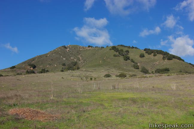
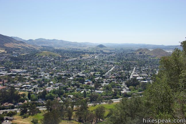
From downtown San Luis Obispo, it’s easy to spot the large white “M” on the side of nearest mountain, Cerro San Luis. If you’ve looked up at the “M,” you may have wondered what it’s like to look down from that big white letter, find out! The “M” is interesting to see up close and its perch provides a panoramic view over San Luis Obispo.
Hikers have a few ways to visit the the “M” representing Mission Prep High School:
- Make it a 0.6-mile extension off the longer hike to the summit of Cerro San Luis
- Hike to the “M” and back as a 1.9-mile outing
- Hike more of the “M” Trail and a portion of Lemon Grove Loop Trail on a 2.4-mile loop
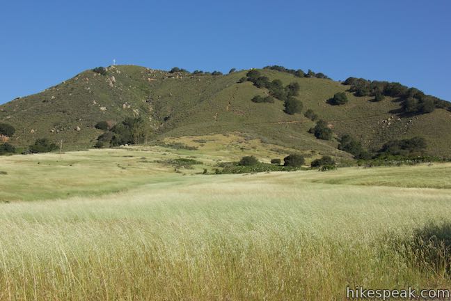
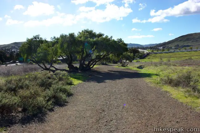
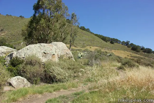
The “M” is about halfway up the east side of Cerro San Luis. The easiest way to get there is to start from the trailhead at the end of Marsh Street on the west side of Highway 101 (that is actually on a short lane called Fernandez Road). This is the main trailhead for Cerro San Luis. Most of the hike to the “M” is in an open space owned by the City of San Luis Obispo, but the mountaintop is privately owned.
Leave the trailhead and hike a tenth of a mile to the first junction. Lemon Grove Loop Trail breaks off to the right and could be used as a hike extension. For the direct route to the “M,” bear left and continue up the main trail. If you’re interested in the Lemon Grove and “M” Trails Loop that covers all 0.95 miles of the “M” Trail, bear right and follow the directions for Lemon Grove and “M” Trails Loop.
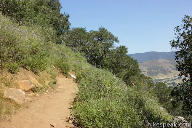
After staying to the left at the first junction, go up the grassy slope another 0.4 miles to a junction with the top end of Lemon Grove Loop Trail. Switchbacks and other improvements have been added to the trail to make the ascent less steep. Stay left past the top of Lemon Grove Loop Trail onto Cerro San Luis Trail. Bear left at the next junction to stay on the main trail.
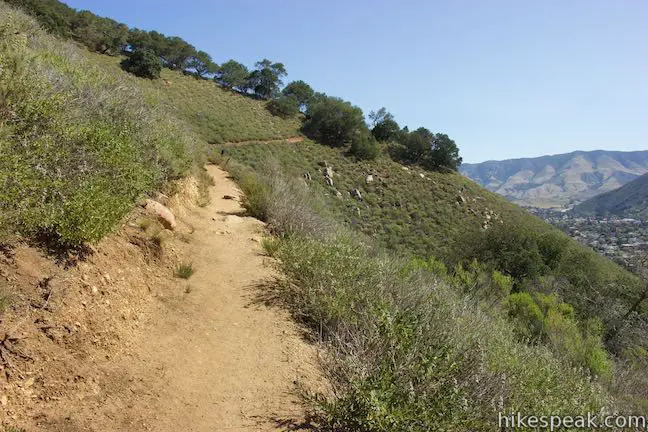
After 0.65 miles of hiking, enter an oak grove come to a junction with the “M” Trail, which ascends to the right and reaches the “M” in just 0.3 miles. Leave the trail to the summit of Cerro San Luis and get on the single-track trail to the “M.”
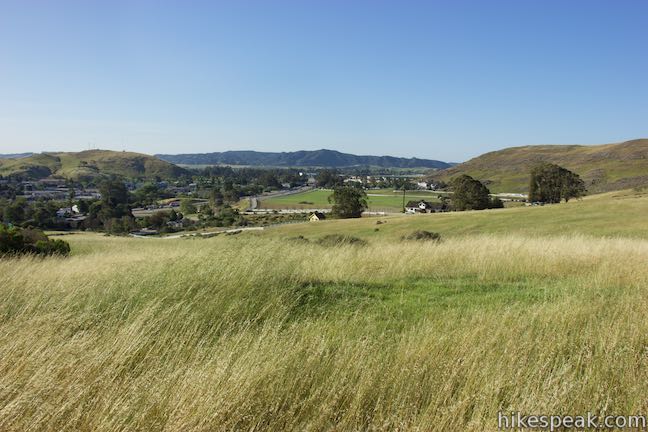
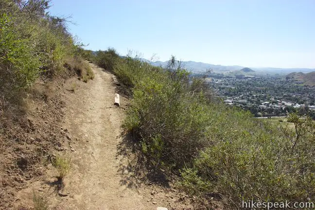
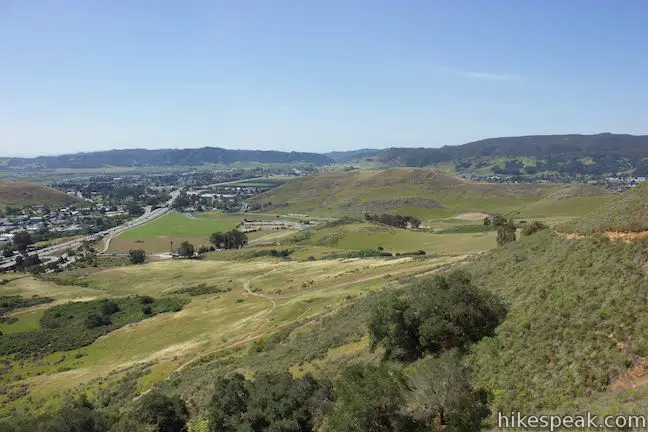
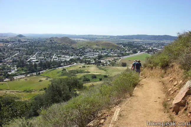
“M” Trail climbs out of the oaks and across a sage-covered slope with nice views to the south and southeast over Edna Valley. Slip through a couple lines of oaks and more chaparral as the trail levels out and comes to the big white “M.”
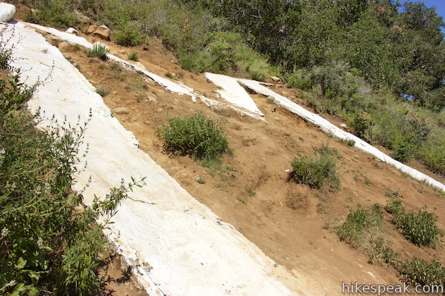
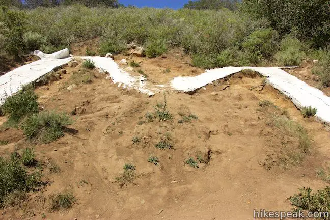
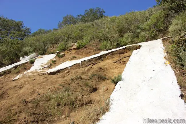
The Cerro San Luis “M”
At the top of the trail, come face to face with the “M,” which is a concrete-formed letter embedded in the steep mountainside and painted white.
The “M” does not represent the Madonna Family, owners of property on Cerro San Luis (sometimes called Madonna Mountain). Instead, the “M” represents Mission College Preparatory High School, located in Downtown San Luis Obispo beneath the mountain.
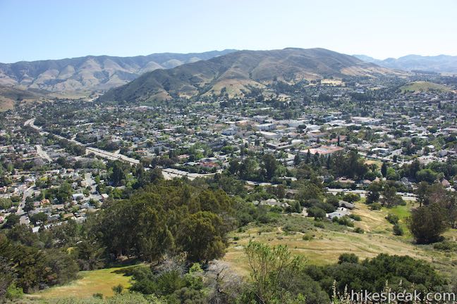
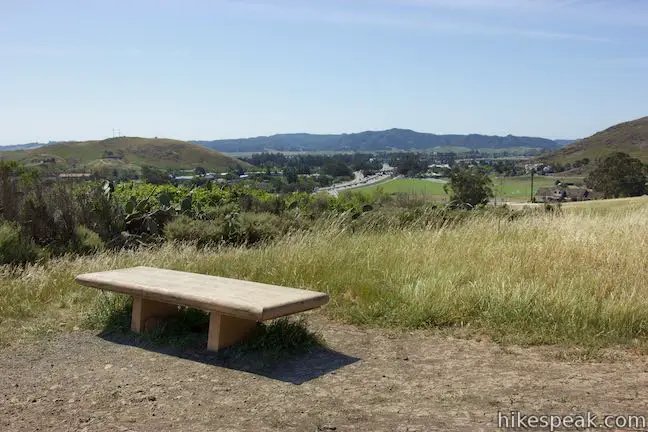
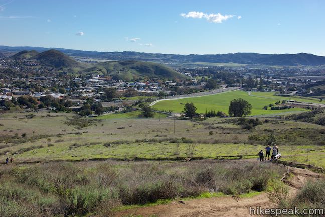
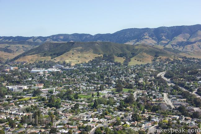
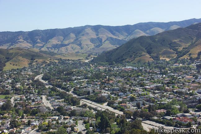
Other schools have put up letters too, showing their school pride, which you can witness from this vantage. All the way to the north, above the university campus, you’ll see the Cal Poly “P” on Yucca Ridge. To the east, on the other side of downtown above San Luis High School on what is called High School Hill or Murray Hill, you’ll see an “SP” representing that institution. School pride aside, the views from the “M” are broad, covering downtown San Luis Obispo and its surroundings.
Hiking on from the “M”
Leave the “M” when you are ready and hike back. North of the “M,” the “M” Trail comes to an unmarked junction with a path that ascends Cerro San Luis. To the right, the “M” Trail descends for 0.65 toward Lemon Grove Loop Trail. The trail ahead takes a weaving cource down a rocky, oak-covered slope. Proceed with the “M” Trail if you’re hiking the Lemon Grove and “M” Trails Loop. To return to Cerro San Luis Trail, either to continue toward the summit or to return to the trailhead for the out-and-back hike to the “M,” simply turn around once you’ve seen the letter.
At the bottom of the “M” Trail, either turn right to hike another 1.35 miles up to the summit of Cerro San Luis or turn left to descend 0.65 miles back to the trailhead to complete the 1.9-mile out-and-back hike to the “M” with 560 feet of elevation change. No fee or permit is required to hike to the “M” on Cerro San Luis. Dogs and bikes are allowed, so get out and enjoy!
To get to the trailhead: From downtown San Luis Obispo, take Higuera Street southeast to Marsh Street and turn right. Pass beneath Highway 101, and turn right on Fernandez Lane (the only road on the right before Marsh Street turns on to the 101 South). Turn right into the dirt parking area. The trail begins at the end of the lot.
Trailhead address: 1183 Fernandez Road, San Luis Obispo, CA 93405
Trailhead coordinates: 35.274897, -120.672369 (35° 16′ 29.62″N 120° 40′ 20.52″W)
You may also view a regional map of surrounding Central Coast trails and campgrounds.


 | Cerro San Luis This 4-mile hike summits one of the Nine Sisters just west of downtown San Luis Obispo. |
 | Lemon Grove Trail This 2.2-mile loop visits a historic lemon grove on the eastern slopes of Cerro San Luis. |
 | Cerro San Luis from Laguna Lake Park This 5.7-mile hike summits one of the Nine Sisters just west of downtown San Luis Obispo. |
 | Bishop Peak This 3.5-mile hike ascends 950 feet to highest summit in the Nine Sisters, offering excellent views of San Luis Obispo and the surrounding Morros. |
 | Felsman Loop Trail This 2.7-mile loop crosses oak, sagebrush, and grass-covered slopes around the base of Bishop Peak, providing excellent views of that notable rocky summit and its San Luis Obispo surroundings. |
 | South Hills Ridge Trail This 1.5-mile round trip hike ascends 425 feet to the highest point in a cluster of hills near downtown San Luis Obispo, offering fine views over the city and surroundings. |
 | Terrace Hill This 0.55-mile hike tours a flattened mountaintop in the city of San Luis Obispo that hosts panoramic views of the surroundings. |
 | Poly Canyon Design Village This 2.5-mile hike visits an experimental architectural village designed by Cal Poly students at the base of the Santa Lucia Mountains. |
 | More hikes in San Luis Obispo Explore other trails around San Luis Obispo including Morro Bay State Park and Montaña de Oro State Park. |
Common Questions about “M” Trail on Cerro San Luis in San Luis Obispo
- Is the trail open?
- Yes. You should expect to find that Hike to the M is open. There are no recent reports of trail closures. If you discover that the trail is closed, please help your fellow hikers by reporting a closure.
- Is this trail free to access?
- Yes, Hike to the M is free to access. No entrance fee, pass, or permit is required. If you discover that access rules have changed, please provide feedback on your experience.
- How much time does this hike take?
- It takes approximately 1 hour 15 minutes to hike Hike to the M. Individual hiking times vary. Add extra time for breaks and taking in the views.
- How long is this hike?
- The hike to Hike to the M is a 1.9 mile out and back with 560 feet of elevation change.
- Are dogs allowed on this trail?
- Yes, dogs are allowed on Hike to the M. The trail is open to hikers, dogs, bikes.
- Where is the trailhead located?
- The trailhead for Hike to the M is located in San Luis Obispo, CA.
Trailhead Address:
1183 Fernandez Road
San Luis Obispo, CA 93405
Trailhead Coordinates:
35.274897, -120.672369 - Are there other trails near Hike to the M?
- Yes, you can find other nearby hikes using the Hikespeak Hike Finder Map.

I’m just curious to ask if this place is okey for a family hiking? Like with kids?
If children can climb trees, sure, why not?